|
Silwan
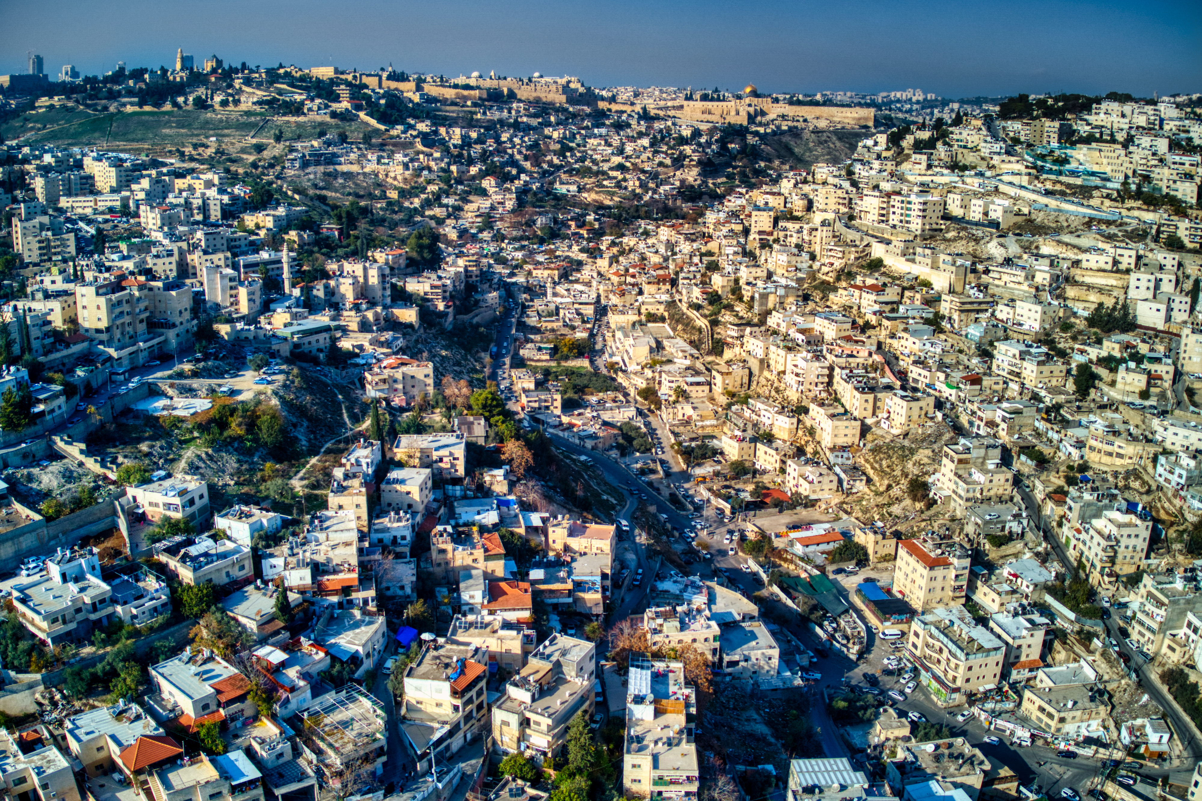
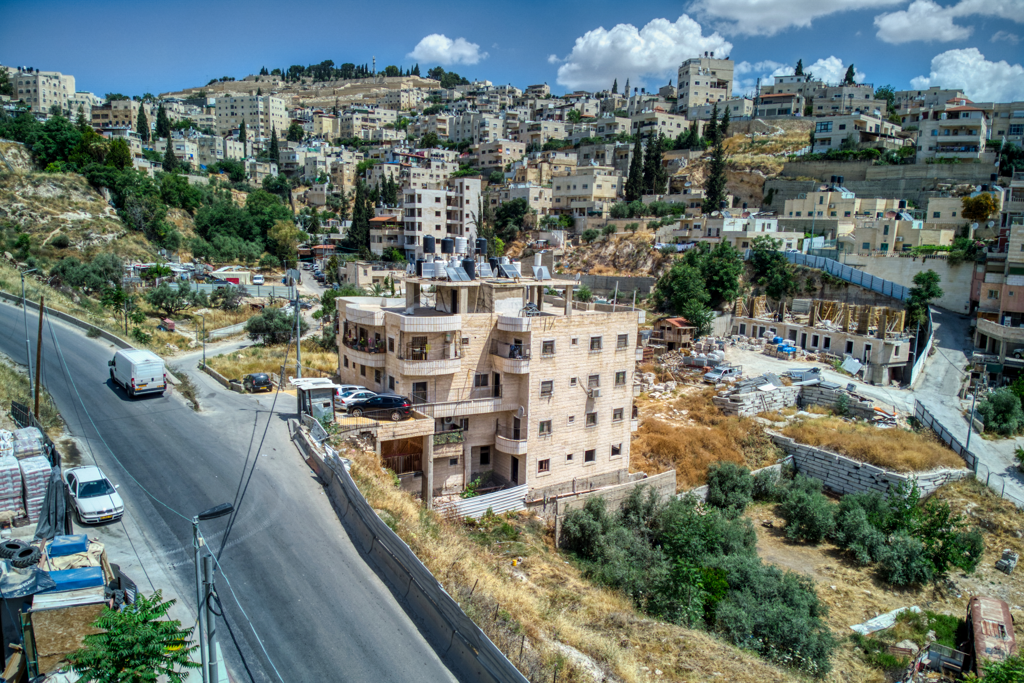
Silwan or Siloam (; ; ) is a predominantly Palestinian district in East Jerusalem, on the southeastern outskirts of the current Old City of Jerusalem.Archaeology and the struggle for Jerusalem ''''. February 5, 2010 It is mentioned in the and the ; in the latter it is the location of Jesus' healing ... [...More Info...] [...Related Items...] OR: [Wikipedia] [Google] [Baidu] |
City Of David (Silwan)
Wadi Hilweh is a neighborhood in the Palestinians, Palestinian Arab village of Silwan, intertwined with an Israeli settlement called the ''City of David''. The neighborhood is called after a section of the Tyropoeon Valley, central valley of ancient Jerusalem, which it straddles. The Silwan area of East Jerusalem was annexed by Israel following the 1967 Six-Day War and 1980 Jerusalem Law, an action not recognized internationally. The international community regards Israeli settlements as illegal under International law and Israeli settlements, international law, although Israel disputes this. The Wadi Hilweh neighborhood stretches over historical Jerusalem's so-called Southeast Hill, extending down from the southern city walls of Old City of Jerusalem, the Old City. According to tradition, Silwan originated at the time of Saladin in the twelfth century on Ras al-Amud, on the southwest slope of the Mount of Olives, then in the early twentieth century it expanded across the Ki ... [...More Info...] [...Related Items...] OR: [Wikipedia] [Google] [Baidu] |
Batn Al-Hawa
Batn al-Hawa is a residential neighborhood inside the village of Silwan, which is located south of the al-Aqsa Mosque, outside the walls of the Old City of Jerusalem. The neighborhood is located on Mount Batn al-Hawa, which is an extension of the Mount of Olives in the eastern corner of Jerusalem; it is separated from it by the Silwan Valley, which connects to the Kidron Valley at the same point, and is known by the Jews as "Har Hashishit" or "The Flood Mountain. History In 1881–82, a group of Jews arrived in Jerusalem coming from Yemen as a result of messianic fervor. The year had special meaning to them, for which some thirty Yemenite Jewish families set out from Sana'a for the Holy Land. It was an arduous journey that took them over half a year to reach Jerusalem, where they arrived destitute of all things. Upon reaching Jerusalem, they sought shelter in the caves and grottoes in the hills facing Jerusalem's walls and Wadi Hilweh, while others moved to Jaffa. Initially ... [...More Info...] [...Related Items...] OR: [Wikipedia] [Google] [Baidu] |
Ateret Cohanim
Ateret Cohanim (), also Ateret Yerushalayim, is an Israeli Jewish organization with a yeshiva located in the Muslim Quarter of the Old City of Jerusalem. It supports the creation of a Jewish majority in the Old City and in Arab neighborhoods in East Jerusalem. Notable alumni of the yeshiva include Rabbi Nissan Ben-Avraham and Rabbi Eyal Karim. History Founded in 1978, it was originally known under the name Atara Leyoshna (lit. “ eturning theformer glory"). After many disagreements about the nature of its activities, the organization closed and re-opened as a new association called Ateret Cohanim with a yeshiva. While the activities of Atara Leyoshna focused mainly on locating Jewish assets in the Muslim Quarter and transferring them into Jewish hands through legal means, the activities of Ateret Cohanim involves acquiring houses in the Muslim quarter or renting them from government companies and populating them with Jews. The association owns many buildings in the Old City, ... [...More Info...] [...Related Items...] OR: [Wikipedia] [Google] [Baidu] |
Mount Of Olives
The Mount of Olives or Mount Olivet (; ; both lit. 'Mount of Olives'; in Arabic also , , 'the Mountain') is a mountain ridge in East Jerusalem, east of and adjacent to Old City of Jerusalem, Jerusalem's Old City. It is named for the olive, olive groves that once covered its slopes. The southern part of the mount was the Silwan necropolis, attributed to the elite of the ancient Kingdom of Judah. The western slopes of the mount, those facing Jerusalem, have been used as a Mount of Olives Jewish Cemetery, Jewish cemetery for over 3,000 years and holds approximately 150,000 graves, making it central in the tradition of Jewish cemetery, Jewish cemeteries. Atop the hill lies the State of Palestine, Palestinian neighbourhood of At-Tur (Mount of Olives), At-Tur, a former village that is now part of East Jerusalem. Several key events in the life of Jesus, as related in the Gospels, took place on the Mount of Olives, and in the Acts of the Apostles it is described as the place from which J ... [...More Info...] [...Related Items...] OR: [Wikipedia] [Google] [Baidu] |
Ras Al-Amud
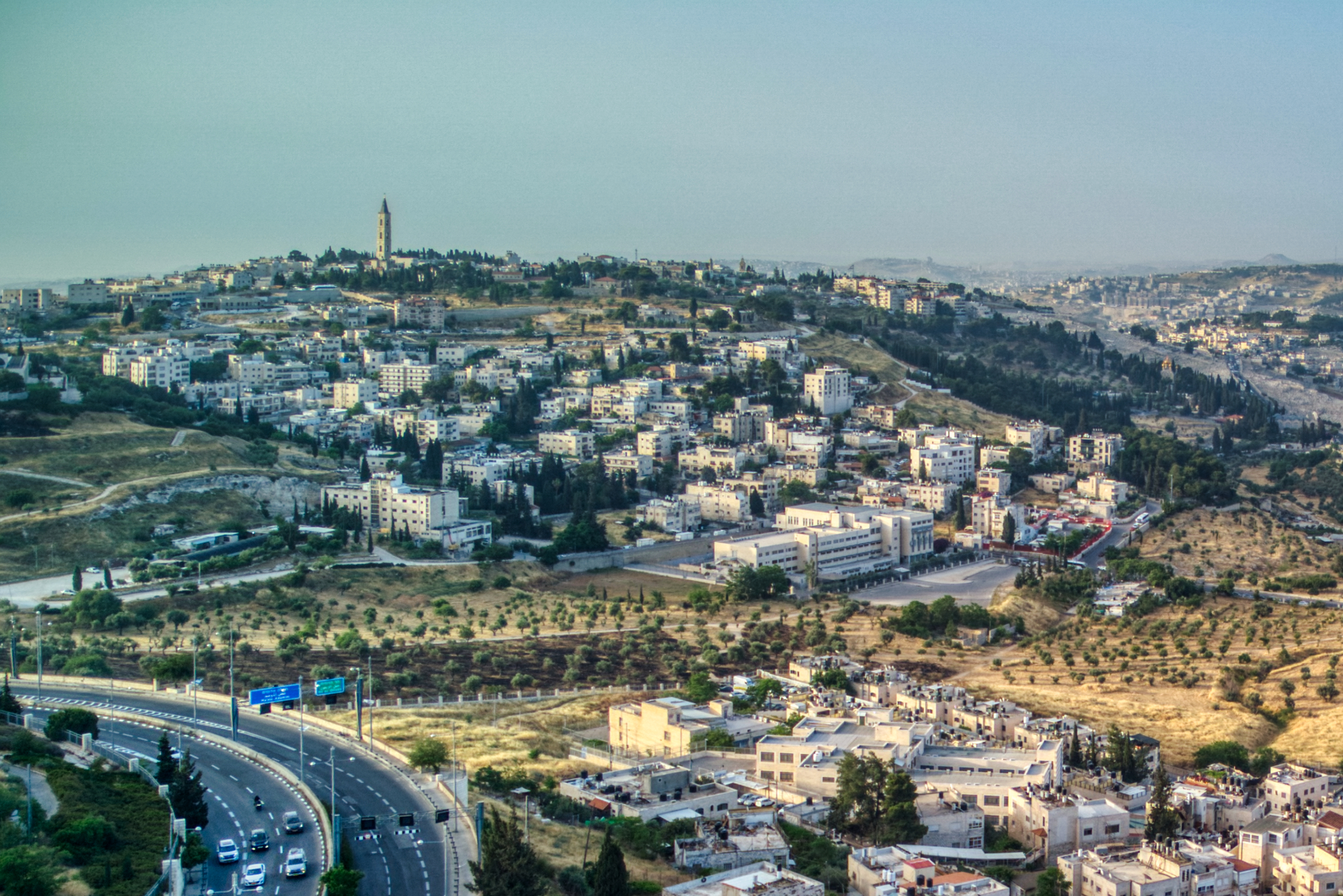
Ras al-Amud (, ; ) is a Palestinian neighborhood in East Jerusalem (which is under Israeli occupation), located southeast of the Old City of Jerusalem, overlooking the Palestinian neighborhoods of Silwan to the south and Abu Dis and al-Eizariya to the east, and bordering the Jewish neighborhood of Ma'ale HaZeitim to the north, which overlooks the Temple Mount. There were about 11,922 Arabs living in the neighborhood in 2003. Israeli settlements Within Ras al-Amud are two Israeli settlements, Ma'ale HaZeitim and Ma'ale David. Ma'ale David is built on the former site of the headquarters of the police headquarters for the Judea and Samaria District, a reference to the West Bank. In September 1997, plans for the construction of a Jewish neighbourhood on the land provoked an international outcry and large Palestinian protests, including in Beit Sahour. Despite American pressure to halt construction, the plan was backed by Jerusalem mayor Ehud Olmert. Under a compromise reached b ... [...More Info...] [...Related Items...] OR: [Wikipedia] [Google] [Baidu] |
East Jerusalem
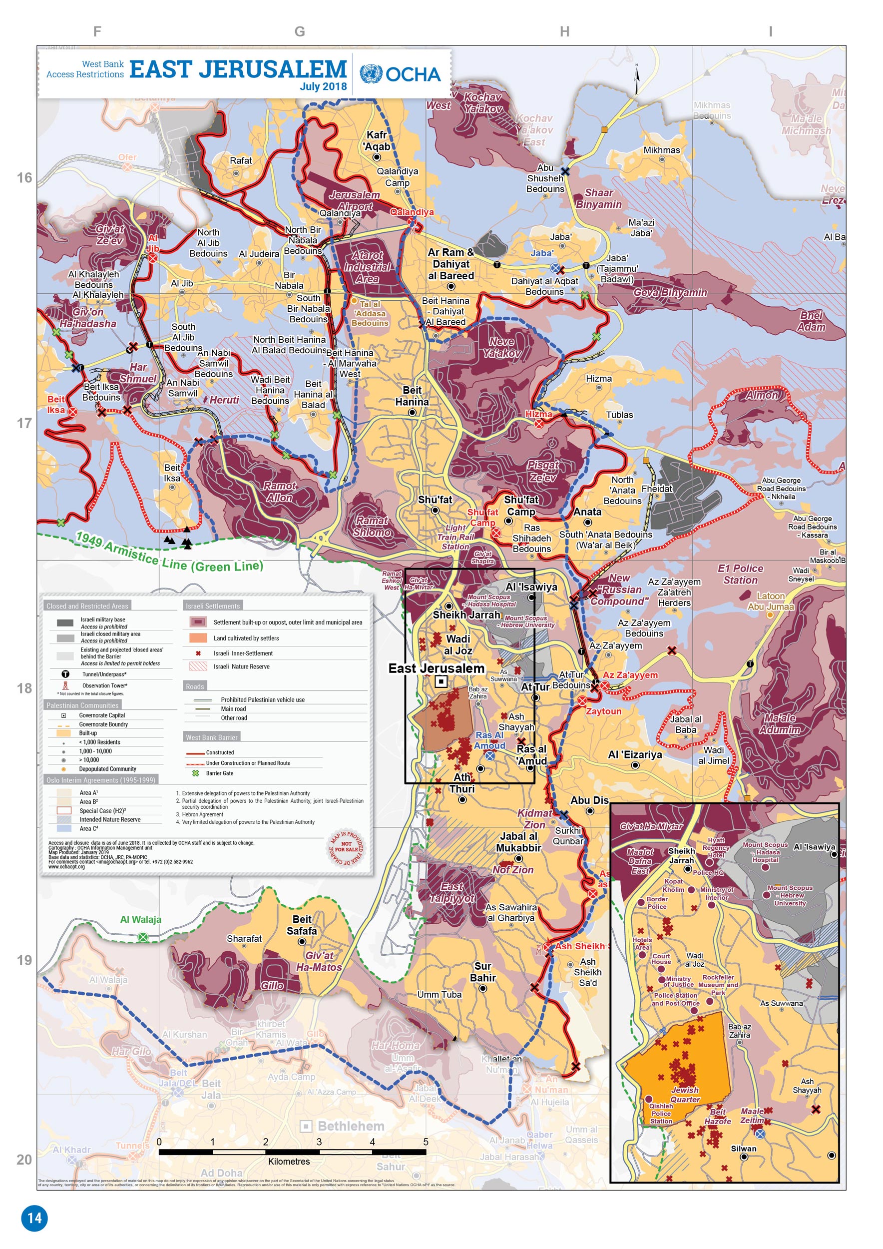
East Jerusalem (, ; , ) is the portion of Jerusalem that was Jordanian annexation of the West Bank, held by Jordan after the 1948 Arab–Israeli War, as opposed to West Jerusalem, which was held by Israel. Captured and occupied in 1967, this area was unilaterally annexed by Israel in 1980. Under international law, East Jerusalem is considered part of the Palestinian territories, and under illegal occupation by Israel. Many states recognize East Jerusalem as the capital of the State of Palestine (such as Brazil, China,China supports Palestinian UN bid (Xinhua, 8 September 2011) "China recognizes Palestine as a country with east Jerusalem as its capital and possessing full sovereignty and independence, in accordance with borders agreed upon in 1967, according to Jiang" Russia ... [...More Info...] [...Related Items...] OR: [Wikipedia] [Google] [Baidu] |
Abu Tor
Abu Tor, also Abu Thor or ath-Thori, (; , lit. Arabic meaning "Father of the Bull"; In Hebrew also called גבעת חנניה (Giv'at Hanania), lit. " Hananiah's hill") is a mixed Jewish and Arab neighborhood in East Jerusalem, built on a prominence south of the Old City. Geography Abu Tor is bounded by the Valley of Hinnom on the north, by the Valley of Azal (Wadi Yasul/Nahal Azal) on the south, Hebron Road and the old Jerusalem Railway Station to the west, and the Sherover Promenade, Armon HaNetziv and Peace Forest to the south. About Abu Tor - Har Refaim Synagogue, Abu Tor, Jerusalem The "official" Hebrew name of the neighborhood is ''Givat Hananya'' ("Hananya's Hill"). His name was Sheikh Shehab ed Din, but he was called "Sheikh Ahmed et Toreh" (Sheikh Ahmed of the bull) or "Abu Tor" (the man with the bull, or the father of the bull) as he was said to have accompanied Saladin riding on a bull.Palmer, 1881, p318/ref>Warren and Conder, 1884, p397/ref> Location The hil ... [...More Info...] [...Related Items...] OR: [Wikipedia] [Google] [Baidu] |
Mount Of Olives Jewish Cemetery
The Jewish Cemetery on the Mount of Olives () is the oldest and most important Jewish cemetery in Jerusalem. The Mount of Olives had been a traditional Hebrew/Jewish burial location in antiquity. The present-day main cemetery is approximately five centuries old, having been first leased from the Jerusalem Islamic Waqf in the sixteenth century.har hazetim – The Jewish Cemetery "from the 16th century the cemetery began to take its present shape" The cemetery contains anywhere between 70,000 and 150,000 tombs, including the tombs of famous figures in |
Old City (Jerusalem)
The Old City of Jerusalem (; ) is a Walls of Jerusalem, walled area in Jerusalem. In a tradition that may have begun with an 1840–41 Royal Engineers maps of Palestine, Lebanon and Syria, 1840s British map of the city, the Old City is divided into four uneven quarters: the Muslim Quarter (Jerusalem), Muslim Quarter, the Christian Quarter, the Armenian Quarter, and the Jewish Quarter (Jerusalem), Jewish Quarter. A fifth area, the Temple Mount, known to Muslims as Al-Aqsa or ''Haram al-Sharif'', is home to the Dome of the Rock, the Al-Aqsa Mosque, and was once the site of Temple in Jerusalem, the Jewish Temple. The Old City's Walls of Jerusalem, current walls and city gates were built by the Ottoman Empire from 1535 to 1542 under Suleiman the Magnificent. The Old City is home to several sites of key importance and holiness to the three major Abrahamic religions: the Temple Mount and the Western Wall for Judaism, the Church of the Holy Sepulchre for Christianity, and the Dome o ... [...More Info...] [...Related Items...] OR: [Wikipedia] [Google] [Baidu] |
Jabel Mukaber
Jabel Mukaber (, ) is a predominantly Palestinian neighborhood in southern East Jerusalem. It is bordered by East Talpiot to the west, Abu Tor and Silwan to the north and Sur Baher to the south. Jabel Mukaber has a population of approximately 30,000 (2017). History According to local legend, Jabel Mukaber is named after Umar ibn al-Khattab, a disciple of Muhammad and the second caliph of the Islamic Caliphate, who cried ''Allahu Akbar'' at this site. It was substantially settled by members of the Bedouin Sawarha tribe at the turn of the 20th century. During the Mandatory Palestine, the offices of the British High Commissioner, the representative of British imperial rule in Mandatory Palestine were located on the ridge of Jabel Mukaber (known as the ''Hill of Evil Counsel'' in medieval Christian tradition, which identified it as the residence of Caiaphas where Judas plotted to kill Jesus). During the 1948 Arab–Israeli War, the Egyptian Muslim Brotherhood battled Jewis ... [...More Info...] [...Related Items...] OR: [Wikipedia] [Google] [Baidu] |
Holy Basin
Holy Basin (, ''HaAgan HaKadosh''), or Historic Basin (, ''HaAgan HaHistori'') is a modern Israeli term for a geographical area in Jerusalem that includes the Old City (Jerusalem), Old City and its adjacent territories. The term was coined by the contemporary Israeli generation as part of a political-academic discourse on how one refers to the area in Jerusalem where the historical and holy sites are concentrated. The term is being used in the field of Geography, geographical research and in contemporary Geopolitics, geo-political studies specializing in urban planning, such as local master plans for Jerusalem and studies concerning the political future of the city. Background The Holy Basin, in effect – Jerusalem, a concentrated geographical area of thousands of years of history and hundreds of holy places – some common to Judaism, Christianity and Islam, and some are unique to one of the three religions. Isaac Tischler maintains that David Ben-Gurion argued that "Jerusalem ... [...More Info...] [...Related Items...] OR: [Wikipedia] [Google] [Baidu] |


