|
Serbia Proper
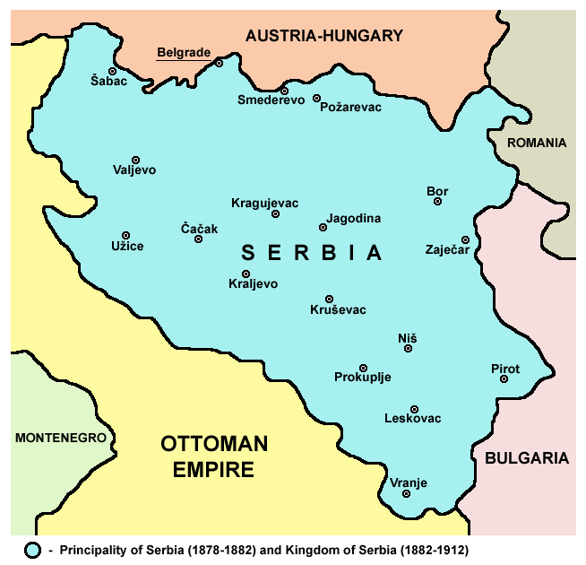
Central Serbia (), also referred to as Serbia proper (), is the region of Serbia lying outside the autonomous province of Vojvodina to the north and the disputed Kosovo region to the south. Central Serbia is a term of convenience, not an administrative division of Serbia as such, and does not have any form of separate administration. Broadly speaking, Central Serbia is the historical core of modern Serbia, which emerged from the Serbian Revolution (1804–17) and subsequent wars against the Ottoman Empire. In the following century, Serbia gradually expanded south, acquiring South Serbia, Kosovo, Sandžak and Vardar Macedonia, and in 1918 – following the unification and annexation of Montenegro and unification of Austro-Hungarian areas left of the Danube and Sava (Vojvodina) – it merged with other South Slavic territories into the Kingdom of Yugoslavia. The current borders of Central Serbia were defined after World War II, when Serbia became a republic within the Socialist F ... [...More Info...] [...Related Items...] OR: [Wikipedia] [Google] [Baidu] |
List Of Sovereign States
The following is a list providing an overview of sovereign states around the world with information on their status and recognition of their sovereignty. The 205 listed states can be divided into three categories based on membership within the United Nations System: 193 member states of the United Nations, UN member states, two United Nations General Assembly observers#Current non-member observers, UN General Assembly non-member observer states, and ten other states. The ''sovereignty dispute'' column indicates states having undisputed sovereignty (188 states, of which there are 187 UN member states and one UN General Assembly non-member observer state), states having disputed sovereignty (15 states, of which there are six UN member states, one UN General Assembly non-member observer state, and eight de facto states), and states having a political status of the Cook Islands and Niue, special political status (two states, both in associated state, free association with New ... [...More Info...] [...Related Items...] OR: [Wikipedia] [Google] [Baidu] |
Kingdom Of Yugoslavia
The Kingdom of Yugoslavia was a country in Southeast Europe, Southeast and Central Europe that existed from 1918 until 1941. From 1918 to 1929, it was officially called the Kingdom of Serbs, Croats, and Slovenes, but the term "Yugoslavia" () has been its colloquial name as early as 1922 due to its origins. "Kraljevina Jugoslavija! Novi naziv naše države. No, mi smo itak med seboj vedno dejali Jugoslavija, četudi je bilo na vseh uradnih listih Kraljevina Srbov, Hrvatov in Slovencev. In tudi drugi narodi, kakor Nemci in Francozi, so pisali že prej v svojih listih mnogo o Jugoslaviji. 3. oktobra, ko je kralj Aleksander podpisal "Zakon o nazivu in razdelitvi kraljevine na upravna območja", pa je bil naslov kraljevine Srbov, Hrvatov in Slovencev za vedno izbrisan." (Naš rod ("Our Generation", a monthly Slovene language periodical), Ljubljana 1929/30, št. 1, str. 22, letnik I.) The official name of the state was changed to "Kingdom of Yugoslavia" by King Alexander I of Yugosla ... [...More Info...] [...Related Items...] OR: [Wikipedia] [Google] [Baidu] |
Mačva
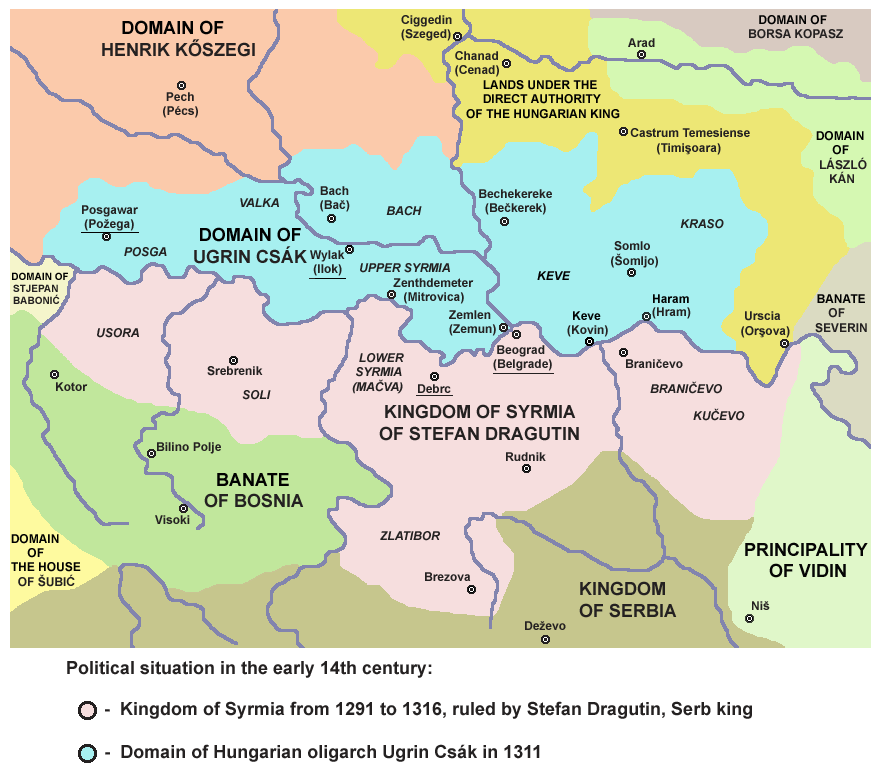
Mačva ( sr-Cyrl, Мачва, ; ) is a geographical and historical region in the northwest of Central Serbia, on a fertile plain between the Sava (river), Sava and Drina rivers. The chief town is Šabac. The modern Mačva District of Serbia is named after the region, although the region of Mačva includes only the northern part of this district. A small northern part of Mačva region is in the Autonomous Province of Vojvodina, in the Syrmia District. Name The region is named after a town of Mačva, which existed in the Medieval Ages near the river Sava. In the past, the region was also known as ''Lower Srem'', while the neighbouring region on the northern bank of the river Sava (present-day Syrmia, Srem) was known as ''Upper Srem''. In Serbian Cyrillic alphabet, Serbian Cyrillic, the region is known as Мачва, in Gaj's Latin alphabet, Serbian Latin, Bosnian language, Bosnian and Croatian language, Croatian as ''Mačva'', in Hungarian language, Hungarian as ''Macsó'' or ''Mac ... [...More Info...] [...Related Items...] OR: [Wikipedia] [Google] [Baidu] |
Šumadija
Šumadija ( sr-Cyrl, Шумадија, ) is a geographical region in the central part of Serbia. The area used to be heavily covered with forests, hence the name (from ''šuma'' 'forest'). The city of Kragujevac is the administrative center of the Šumadija District in the Šumadija and Western Serbia statistical region. This very fertile region is known for its extensive fruit production (apples, grapes, plums, etc.). Name ''Šumadija'' was named for the dense, impassable forests that covered the region. These forests were preserved until the early 19th century; they are mentioned in literature and tradition. Bertrandon de la Broquière (1400–1459) passed through Serbia; on the road from Palanka to Belgrade he "passed through very large forests." During the reign of Prince Miloš (1817–1839), it was said of the dense forests that covered Serbia, "no one could walk through (them), let alone with horse." When Alphonse de Lamartine visited Serbia in 1833, he wrote that h ... [...More Info...] [...Related Items...] OR: [Wikipedia] [Google] [Baidu] |
Balkan Mountains
The Balkan mountain range is located in the eastern part of the Balkan peninsula in Southeast Europe, Southeastern Europe. It is conventionally taken to begin at the peak of Vrashka Chuka on the border between Bulgaria and Serbia. It then runs for about , first in a south-easterly direction along the border, then eastward across Bulgaria, forming a natural barrier between the northern and southern halves of the country, before finally reaching the Black Sea at Cape Emine. The mountains reach their highest point with Botev Peak at . In much of the central and eastern sections, the summit forms the watershed between the drainage basins of the Black Sea and the Aegean Sea, Aegean. A prominent gap in the mountains is formed by the predominantly narrow Iskar Gorge, a few miles north of the Bulgarian capital, Sofia. The karst relief determines the large number of caves, including Magura Cave, Magura, featuring the most important and extended European post-Palaeolithic cave painting, Le ... [...More Info...] [...Related Items...] OR: [Wikipedia] [Google] [Baidu] |
Serbian Carpathians
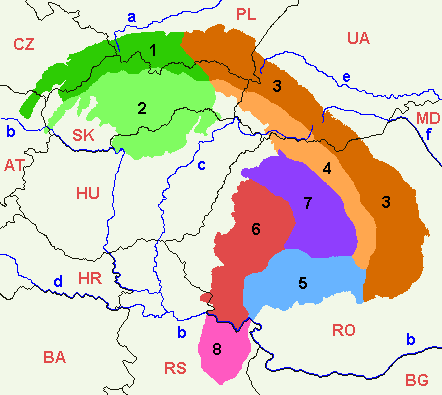
Serbian Carpathians () is a mountain range in eastern Central Serbia, located in Central Europe. It presents an extension of proper Carpathian Mountains across the Danube, connecting them with the Balkan Mountains in the southeast. They stretch in north–south direction in eastern Serbia, east of the Great Morava valley and west of the White Timok Valley and north of the Nišava Valley. The mountains are 800–1500 m high, and dominated by karst limestone geologic features, the highest one being Rtanj Mountain (1,565 m). Definitions Under the strict definition (as defined by the Serbian Academy of Sciences and Arts and adopted by the Carpathian Convention), Serbian part of the Carpathian Mountains covers only 732 km2, or less than 1% of the total Carpathian area. That part encompasses the southern bank of the Iron Gate and the area of Đerdap National Park. The extreme points of so defined Carpathian area in Serbia are Tekija in the north, in the south, Golubac ... [...More Info...] [...Related Items...] OR: [Wikipedia] [Google] [Baidu] |
Dinaric Alps
The Dinaric Alps (), also Dinarides, are a mountain range in Southern Europe, Southern and Southcentral Europe, separating the continental Balkan Peninsula from the Adriatic Sea. They stretch from Italy in the northwest through Slovenia, Croatia, Bosnia and Herzegovina, Serbia, Montenegro, and Kosovo to Albania in the southeast. The Dinaric Alps extend for approximately along the western Balkan Peninsula from the Julian Alps of the northeast Italy, downwards to the Šar Mountains, Šar and Korab (mountain), Korab massif, where their direction changes. The Accursed Mountains are the highest section of the entire Dinaric Alps; this section stretches from Albania to Kosovo and eastern Montenegro. Maja Jezercë, standing at Metres above the Adriatic, above the Adriatic, is the highest peak and is located in Albania. The Dinaric Alps are one of the most rugged and extensive mountainous areas of Europe, alongside the Caucasus Mountains, Alps, Pyrenees, Carpathian Mountains and Scand ... [...More Info...] [...Related Items...] OR: [Wikipedia] [Google] [Baidu] |
Great Morava
The Great Morava (, ) is the final section of the Morava ( sr-Cyrl, Морава), a major river system in Serbia. Etymology According to Predrag Komatina from the Institute for Byzantine Studies in Belgrade, the Great Morava is named after the Merehani, an early Slavic tribe who were still unconquered by the Bulgars during the time of the Bavarian Geographer. However, after 845, the Bulgars added these Slavs to their ''societas'' (they are last mentioned in 853). Length The Great Morava begins at the confluence of the South Morava and the West Morava, located near the village of Stalać, a major railway junction in Central Serbia. From there to its confluence with the Danube northeast of the city of Smederevo, the Velika Morava is 185 km long. With its longer branch, the West Morava, it is 493 km long. The South Morava, which represents the natural headwaters of the Morava, used to be longer than the West Morava, but due to the regulations of river bed and ... [...More Info...] [...Related Items...] OR: [Wikipedia] [Google] [Baidu] |
Bulgaria
Bulgaria, officially the Republic of Bulgaria, is a country in Southeast Europe. It is situated on the eastern portion of the Balkans directly south of the Danube river and west of the Black Sea. Bulgaria is bordered by Greece and Turkey to the south, Serbia and North Macedonia to the west, and Romania to the north. It covers a territory of and is the tenth largest within the European Union and the List of European countries by area, sixteenth-largest country in Europe by area. Sofia is the nation's capital and List of cities and towns in Bulgaria, largest city; other major cities include Burgas, Plovdiv, and Varna, Bulgaria, Varna. One of the earliest societies in the lands of modern-day Bulgaria was the Karanovo culture (6,500 BC). In the 6th to 3rd century BC, the region was a battleground for ancient Thracians, Persians, Celts and Ancient Macedonians, Macedonians; stability came when the Roman Empire conquered the region in AD 45. After the Roman state splintered, trib ... [...More Info...] [...Related Items...] OR: [Wikipedia] [Google] [Baidu] |
North Macedonia
North Macedonia, officially the Republic of North Macedonia, is a landlocked country in Southeast Europe. It shares land borders with Greece to the south, Albania to the west, Bulgaria to the east, Kosovo to the northwest and Serbia to the north. It constitutes approximately the northern third of the larger geographical Macedonia (region), region of Macedonia. Skopje, the capital and largest city, is home to a quarter of the country's population of over 1.83 million. The majority of the residents are ethnic Macedonians (ethnic group), Macedonians, a South Slavs, South Slavic people. Albanians in North Macedonia, Albanians form a significant minority at around 25%, followed by Turks in North Macedonia, Turks, Romani people in North Macedonia, Roma, Serbs in North Macedonia, Serbs, Bosniaks in North Macedonia, Bosniaks, Aromanians in North Macedonia, Aromanians and a few other minorities. The region's history begins with the Paeonia (kingdom), kingdom of Paeonia. In the la ... [...More Info...] [...Related Items...] OR: [Wikipedia] [Google] [Baidu] |
Kosovo
Kosovo, officially the Republic of Kosovo, is a landlocked country in Southeast Europe with International recognition of Kosovo, partial diplomatic recognition. It is bordered by Albania to the southwest, Montenegro to the west, Serbia to the north and east, and North Macedonia to the southeast. It covers an area of and has a population of approximately 1.6 million. Kosovo has a varied terrain, with high plains along with rolling hills and List of mountains in Kosovo, mountains, some of which have an altitude over . Its climate is mainly Continental climate, continental with some Mediterranean climate, Mediterranean and Alpine climate, alpine influences. Kosovo's capital and List of cities and towns in Kosovo#List, most populous city is Pristina; other major cities and urban areas include Prizren, Ferizaj, Gjilan and Peja. Kosovo formed the core territory of the Dardani, an ancient Paleo-Balkanic languages, Paleo-Balkanic people attested in classical sources from the 4th cent ... [...More Info...] [...Related Items...] OR: [Wikipedia] [Google] [Baidu] |
Montenegro
, image_flag = Flag of Montenegro.svg , image_coat = Coat of arms of Montenegro.svg , coa_size = 80 , national_motto = , national_anthem = () , image_map = Europe-Montenegro.svg , map_caption = , image_map2 = , capital = Podgorica , coordinates = , largest_city = capital , official_languages = Montenegrin language, Montenegrin , languages2_type = Languages in official use , languages2 = , ethnic_groups = , ethnic_groups_ref = , ethnic_groups_year = 2023 census , religion = , religion_ref = , religion_year = 2023 census , demonym = Montenegrins, Montenegrin , government_type = Unitary parliamentary republic , leader_title1 = President of Montenegro, President , leader_name1 = Jakov Milatović , leader_title2 ... [...More Info...] [...Related Items...] OR: [Wikipedia] [Google] [Baidu] |


