|
Seatoun
Seatoun is an eastern suburb of Wellington, the capital city of New Zealand and lies on the east coast of the Miramar Peninsula, close to the entrance to Wellington Harbour (Port Nicholson). Geography The suburb sits on an exposed promontory close to Barrett Reef, a dangerous area of rocky shallows upon which many ships have foundered. Seatoun as a suburb looks out on to Steeple Rock/Te Aroaro-o-Kupe, a large rock at the west of the Wellington Harbour entrance, rising above sea level. History The traditional Māori name for the Seatoun area is ''.'' It is where the mythical Polynesian navigator, Kupe, is said to have first set ashore on his voyage to New Zealand, around 1000–1300 BC. Kupe is also said to have named the foreshore '','' after the rattling and rumbling caused by the waves disturbing gravel on the beach. The first settlement of the surrounding area was by Māori, led by the semi-mythical explorer Tara, or more fully Tara-Ika i Nohu, who also gave his n ... [...More Info...] [...Related Items...] OR: [Wikipedia] [Google] [Baidu] |
Seatoun AFC
Seatoun AFC is a football club in New Zealand, based in the Wellington suburb of Seatoun. The club was founded in 1909 by Charlie Webb. History One of the strongest clubs in the country during the 1950s, it won the national knockout Chatham Cup in 1957 and 1958. Their 1958 win, a 7–1 win over Christchurch City, remains the highest score by any team in a Chatham Cup final (equalled in 1989 by Christchurch United Christchurch United Football Club is a Professionalism in association football, professional football club in Christchurch, New Zealand. They compete in various Mainland Football competitions at Junior and Senior level. The club has won six N ...). 11 players (senior men) have represented NZ whilst playing for Seatoun - Grahame Bilby, Rex Boyes, Keith Gibson, Bert Hiddlestone, Mike Jones, Ron Kearns, Rodney Reid, Duncan Ritchie, Dave Strom, Phil Traynor, Ian Upchurch. Also a number of international players have played for Seatoun at some stage including Paul ... [...More Info...] [...Related Items...] OR: [Wikipedia] [Google] [Baidu] |
Miramar Peninsula
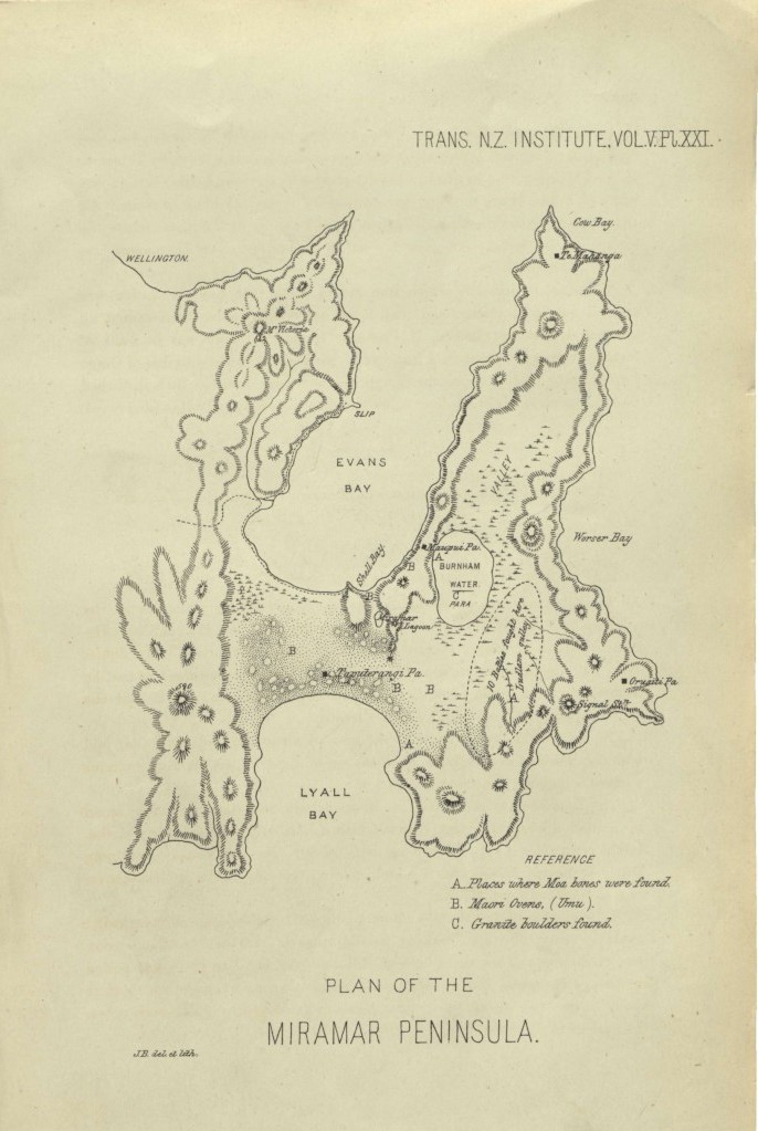
Te Motu Kairangi / Miramar Peninsula is a large peninsula on the southeastern side of the city of Wellington, New Zealand. It is located at the entrance to Wellington Harbour, in Wellington's eastern suburbs. According to Māori legend, it was formed at the same time that the taniwha Whaitaitai beached at nearby Hataitai as he tried to escape the confines of the harbour. It contains the large suburbs of Miramar, Maupuia, Seatoun and Strathmore Park and several smaller suburbs. Geography The peninsula was originally an island, separated from the main island ( Te Ika a Māui) by a sea channel called Te Awa-a-Taia (the channel of Taia). The peninsula area later became known as Hataitai or Whataitai. Around 1460 AD an earthquake named " Haowhenua" (earth swallower) raised the land, eliminating the shallow channel and joining the island to the mainland by an isthmus where Rongotai and Lyall Bay are now. There was a flat plain and freshwater lake in the centre of the peninsul ... [...More Info...] [...Related Items...] OR: [Wikipedia] [Google] [Baidu] |
Coutts Crawford
James Coutts Crawford (19 January 1817 – 8 April 1889), known as Coutts Crawford, was a naval officer, farmer, scientist, explorer and public servant in New Zealand. He was born in Strathaven, South Lanarkshire, Scotland in 1817 and came to New Zealand in 1839. He settled in Wellington, owning the Miramar Peninsula and parts of Rongotai and Kilbirnie, New Zealand, Kilbirnie, which he named after the Kilbirnie, town in Scotland. Crawford was active in local affairs. He served on the New Zealand Legislative Council from 1859 to 1867. He died in London in 1889. Mount Crawford (South Australia) and several locations in Wellington are named after him. Early life and family Crawford was born in Strathaven, South Lanarkshire, Scotland, the son of naval officer James Coutts Crawford, and his second wife, Jane Inglis. His maternal grandfather was Admiral John Inglis (Royal Navy officer), John Inglis. Crawford was educated at the Royal Naval College in Portsmouth, then went to sea w ... [...More Info...] [...Related Items...] OR: [Wikipedia] [Google] [Baidu] |
Worser Bay
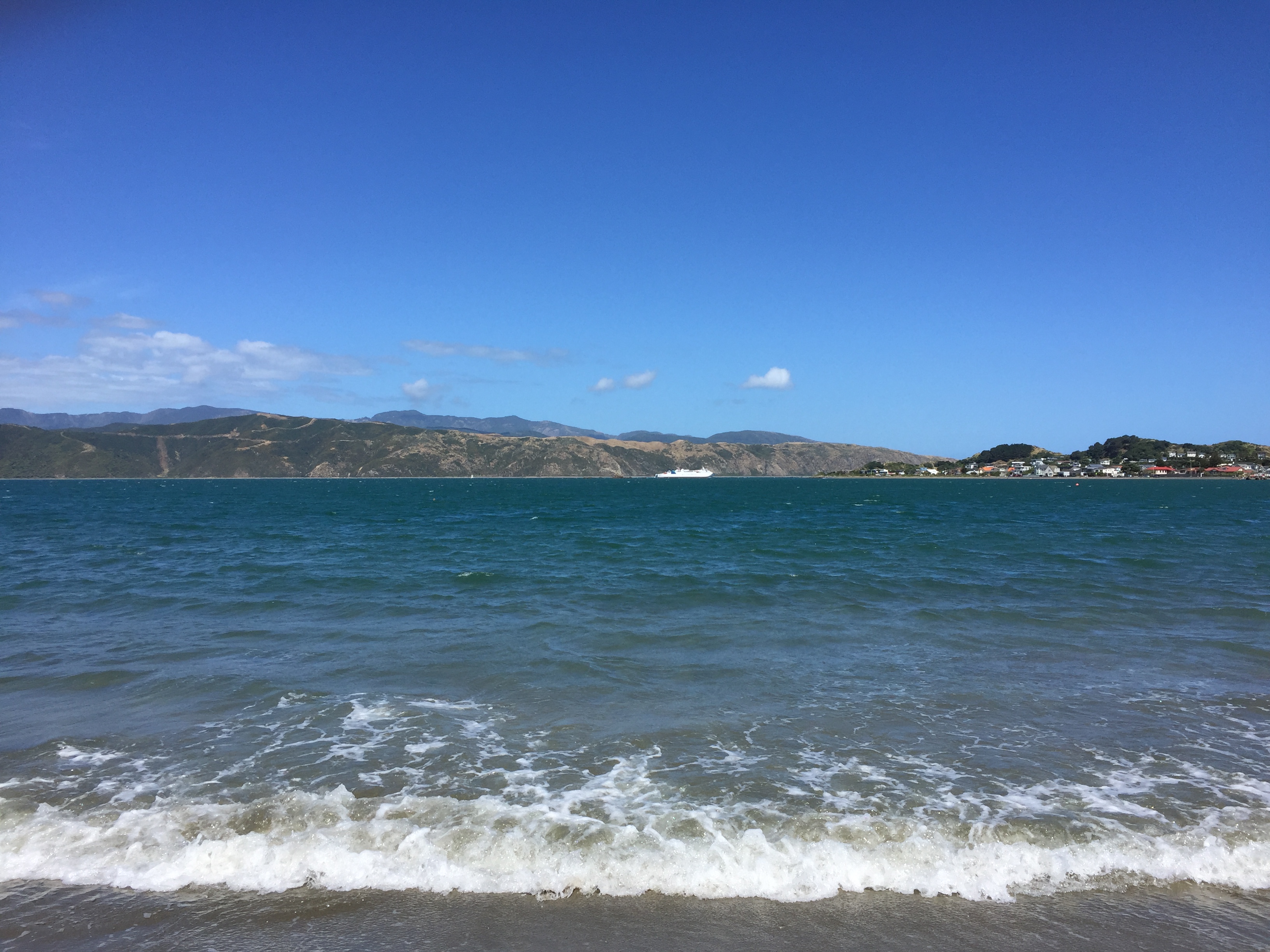
Worser Bay in Wellington, New Zealand is along the beach from Seatoun and over the hill from Miramar on the Miramar Peninsula. It has a calm sandy beach with a road running along the base of the Seatoun Heights hill. Houses run all along the hill side of the road, with only carparks and beach facilities opposite. The beach is subject to the windy conditions of Wellington with gusty northerlies often changing to cold, consistent southerlies. The waters are calm as the beach is within the natural harbour and in summer it is a popular destination for families, much like the nearby Scorching Bay. Named after James Heberley's frequent predictions of "worser" weather, the beach still has the original pilot's cottage that housed James and other pilots from 1866. Features The Worser Bay yacht club, scout hall and surf club buildings are located at the northern end of the beach. The Worser Bay Boating Club was founded in 1926 and has become a leader in the New Zealand-specific S ... [...More Info...] [...Related Items...] OR: [Wikipedia] [Google] [Baidu] |
Breaker Bay
Breaker Bay is a suburb on the south east coast of Wellington City in New Zealand, on the Miramar Peninsula. The suburb contains a 600 m wide bay with the same name. Geography Breaker Bay is a thin strip of land along the southeast coast of Miramar Peninsula. The suburb includes five bays; the largest, Breaker Bay, is at its north, with the other bays going south being Eve Bay, Flax Bay, Reef Bay, and Palmer Bay. It is part of the western shore of the Wellington Harbour entrance. The suburb of Breaker Bay is named after its largest bay. F. L. Irvine-Smith wrote in 1948, "South from Seatoun is Breaker Bay (by no means a misnomer) reached by the Pass of Branda, named from the well-known pass at the head of Loch Awa ic. The Pass of Branda forms the northern entrance to the suburb. The area is known for southerly gales as it is exposed to Cook Strait. Waves would often crash over the road in winter, and intense storms put pressure on the coastline which is facing eros ... [...More Info...] [...Related Items...] OR: [Wikipedia] [Google] [Baidu] |
Steeple Rock
Steeple Rock/Te Aroaro-o-Kupe is a large rock off Seatoun at the west of the entrance to Wellington Harbour, rising above sea level. The rock plays a role in warning ships off the coast. It is the location of a marine light and an unbeaconed trig station (‘Steeple Rock Light’, Survey marker, geodetic code B0XX). Its Māori language, Māori name is Te Aroaro-o-Kupe (The front of Kupe or The presence of Kupe). The name was officially changed in 2009 from the English "Steeple Rock" to the current dual name of Steeple Rock/Te Aroaro-o-Kupe as part of the 2009 Treaty of Waitangi claims and settlements, Treaty of Waitangi settlement between Taranaki Whānui ki te Upoko o te Ika and the New Zealand government. The previous Māori name of the rock was Te Ure o Kupe (The penis of Kupe). Kupe, the legendary discoverer of Aotearoa, is said to have injured himself on the rock while swimming. In earlier times Steeple Rock was also known as Pinnacle Rock. This should not be confused with ... [...More Info...] [...Related Items...] OR: [Wikipedia] [Google] [Baidu] |
Wellington City Council
Wellington City Council is a Territorial authorities of New Zealand, territorial authority in New Zealand, governing the city of Wellington, the country's capital city and List of cities in New Zealand#City councils, third-largest city by population, behind Auckland and Christchurch. It consists of the central historic town and certain additional areas within the Wellington#Wellington metropolitan area, Wellington metropolitan area, extending as far north as Linden, New Zealand, Linden and covering rural areas such as Mākara and Ohariu, New Zealand, Ohariu. The city adjoins Porirua in the north and Lower Hutt, Hutt City in the north-east. It is one of nine territorial authorities in the Wellington Region. The council represents a population of as of and consists of a mayor and fifteen councillors elected from six wards (Northern, Onslow-Western, Lambton, Eastern, Southern general wards and Te Whanganui-a-Tara Māori wards and constituencies, Māori ward). It administers publi ... [...More Info...] [...Related Items...] OR: [Wikipedia] [Google] [Baidu] |
Miramar, New Zealand
Miramar is a suburb of Wellington, New Zealand, south-east of the city centre. It is on the Miramar Peninsula, directly east of the isthmus of Rongotai, the site of Wellington International Airport. History Miramar Peninsula was originally an island, separated from Kilbirnie by a sea channel called Te Awa-a-Taia (the channel of Taia); this was where the Rongotai isthmus is now. The original Māori name for the whole area when it was still an island was Te Motu Kairangi (meaning "esteemed" or "precious" island). 'Miramar' means 'sea view' in Spanish. The name was chosen by the first European to settle in the area, Scotsman Coutts Crawford (1817–1889). Crawford was a former Royal Navy officer turned businessman and colonist, who arrived in Wellington in 1840. Crawford established a farm on Miramar Peninsula, which at the time was known as Watt's Peninsula, and drained a large lagoon known as Para Lake or Burnham Water. The lagoon covered much of the low-lying land in the c ... [...More Info...] [...Related Items...] OR: [Wikipedia] [Google] [Baidu] |
Wellington
Wellington is the capital city of New Zealand. It is located at the south-western tip of the North Island, between Cook Strait and the Remutaka Range. Wellington is the third-largest city in New Zealand (second largest in the North Island), and is the administrative centre of the Wellington Region. It is the world's southernmost capital of a sovereign state. Wellington features a temperate maritime climate, and is the world's windiest city by average wind speed. Māori oral tradition tells that Kupe discovered and explored the region in about the 10th century. The area was initially settled by Māori iwi such as Rangitāne and Muaūpoko. The disruptions of the Musket Wars led to them being overwhelmed by northern iwi such as Te Āti Awa by the early 19th century. Wellington's current form was originally designed by Captain William Mein Smith, the first Surveyor General for Edward Wakefield's New Zealand Company, in 1840. Smith's plan included a series of inter ... [...More Info...] [...Related Items...] OR: [Wikipedia] [Google] [Baidu] |
Strathmore Park
Strathmore Park is a suburb of Wellington City, New Zealand. It is located at the southern end of the Miramar Peninsula to the south of the suburb of Miramar, and due east of the airport. A hill suburb, it overlooks Lyall Bay (which lies to the west), Evans Bay (to the North) and several bays along the Seatoun coast close to the mouth of Wellington Harbour, which lies to the east. Strathmore Park is noted for several areas of open land, including the Beacon Hill Reserve and Miramar Golf Course. The southern end of the suburb is dominated by Atatürk Park, which is located high above Tarakena Bay. The site was chosen for its similarity to the landscape of Gallipoli, and was erected as part of a joint agreement with the Turkish and Australian governments in mutual respect of the men of both sides who lost their lives in the Gallipoli Campaign of World War I. The Memorial was designed by Ian Bowman and unveiled in 1990. History Strathmore Park grew after the private secon ... [...More Info...] [...Related Items...] OR: [Wikipedia] [Google] [Baidu] |
Wellington Harbour
Wellington Harbour ( ), officially called Wellington Harbour / Port Nicholson, is a large natural harbour on the southern tip of New Zealand's North Island. The harbour entrance is from Cook Strait. Central Wellington is located on parts of the western and southern sides of the harbour, and the suburban area of Lower Hutt is to the north and east. The harbour area bounded by a line between Pencarrow Head to Petone foreshore, was officially named Port Nicholson until it assumed its current dual name in 1984. Toponymy The earliest known Māori name for the area, ''Te Upoko-o-te-Ika-a-Māui'', is derived from Māori legend and translates literally as "the head of Māui's fish". ''Te Whanganui-a-Tara'', another Māori name for the area, translates literally as "the great harbour of Tara". It is believed to refer to Tara, a son of the Polynesian explorer Whātonga, who was sent down from the Māhia Peninsula by his father to explore southern lands for their people to se ... [...More Info...] [...Related Items...] OR: [Wikipedia] [Google] [Baidu] |
Matiu / Somes Island
Matiu / Somes Island is the largest of three islands in the northern half of Wellington Harbour, New Zealand. The island is 24.9 hectares (62 acres) in area, and lies 3 kilometres (1.9 mi) south of the suburb of Petone and the mouth of the Hutt River. Matiu / Somes Island was used as a place of refuge by pre-colonial Māori. Middens and other remnants of habitation have been found on the island. There is also a long and varied European history. The island was used for human quarantine from 1840 until the 1920s. Ships arriving in Wellington Harbour with infectious passengers or crew would disembark them at Matiu / Somes Island for care and treatment before berthing in the city. During both World War I and World War II, "enemy aliens", including long-term residents of New Zealand who originated from enemy countries, were interned on the island. Anti-aircraft gun emplacements were also built on the island during World War II and their remains can be seen today. The island was u ... [...More Info...] [...Related Items...] OR: [Wikipedia] [Google] [Baidu] |


