|
Saloum River
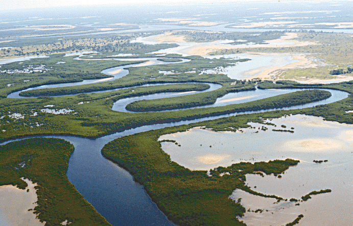
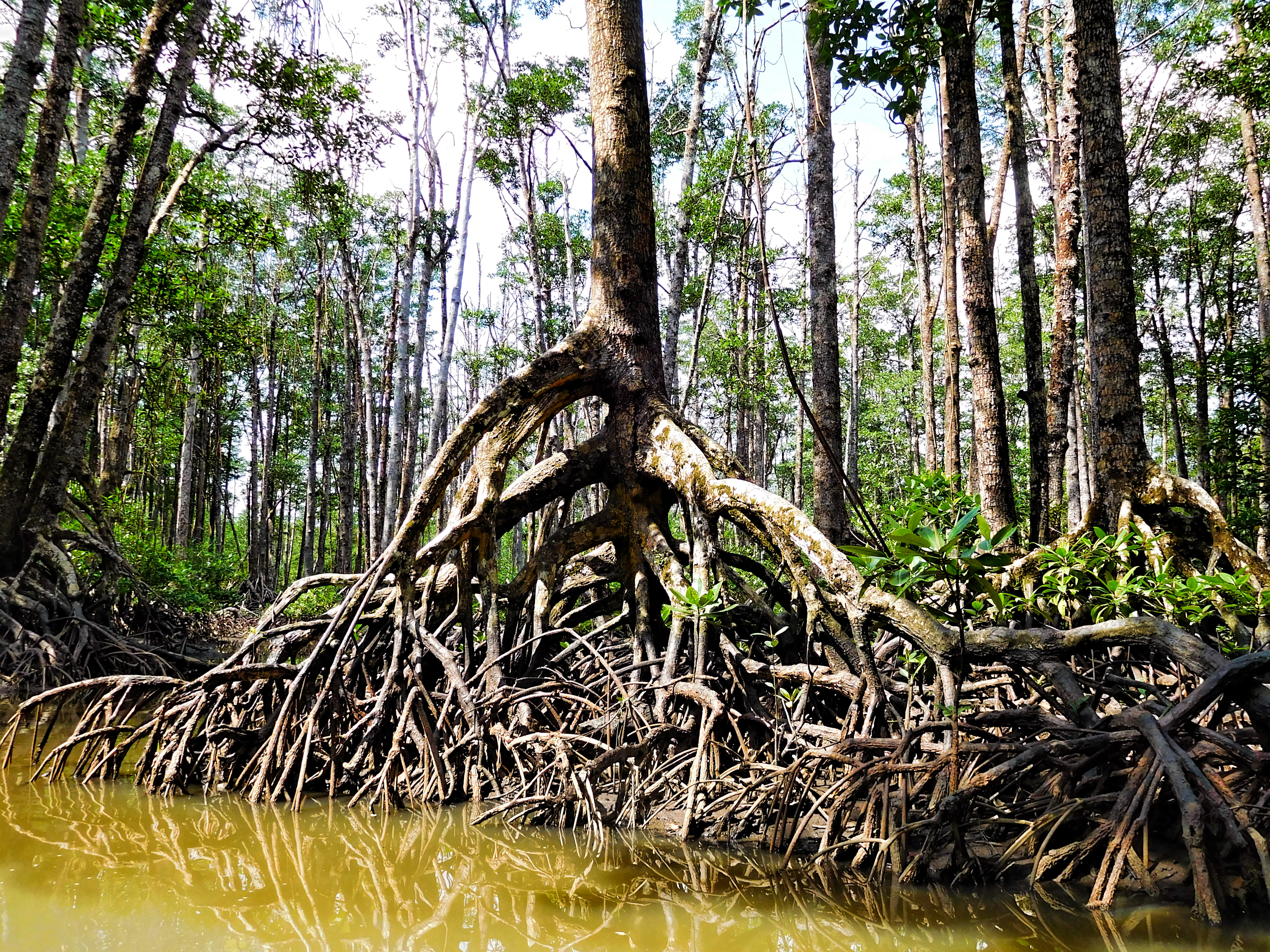
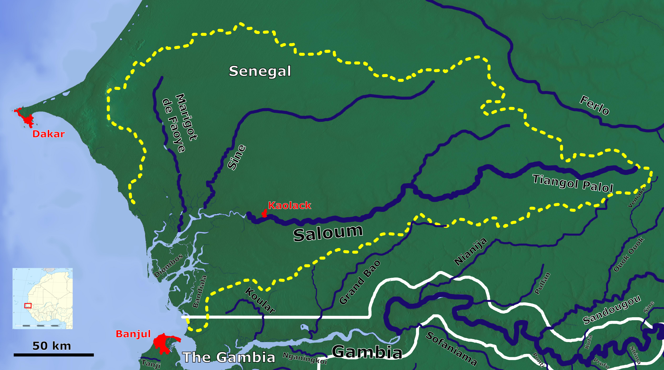
The Saloum River (French: ''Fleuve Saloum'') rises about 105 kilometers east of Kaolack, Senegal, and flows into the Atlantic Ocean. The Saloum Delta is located at its mouth, in the protected Saloum Delta National Park. The river basin lies within what was the pre-colonial Serer kingdom, Saloum. Mangrove forests occupy a five-kilometer belt on both banks over sixty kilometers upstream. See also *Sine River *Sine-Saloum Sine-Saloum is a region in Senegal located north of the Gambia and south of the Petite Côte. It encompasses an area of 24,000 square kilometers, about 12% of Senegal, with a population in the 1990s of 1,060,000. The western portion contains the ... References A Directory of African Wetlands Robert Mepham, R. H. Hughes, G. M. Bernacsek, International Union for Conservation of Nature and Natural Resources, United Nations Environment Programme, World Conservation Monitoring Centre, 1992. Rivers of Senegal Serer country {{Senegal-river-stub ... [...More Info...] [...Related Items...] OR: [Wikipedia] [Google] [Baidu] |
Saloum
The Kingdom of Saloum ( Serer: ''Saluum'' or ''Saalum'') was a Serer kingdom in present-day Senegal and parts of Gambia. The precolonial capital was the city of Kahone. Re-established in 2017, Saloum is now a non-sovereign traditional monarchy within Senegal. Its history, geography and culture is intricately linked with the sister state, the Kingdom of Sine, and it is common to refer to them as the Sine-Saloum or the Serer Kingdoms. Typonymy Serer oral traditions recount that the area was named Saluum/Saloum by the Maad Saloum Mbegane Ndour in the later part of the 15th century (c. 1494),Ba, Abdou Bouri, « Essai sur l’histoire du Saloum et du Rip », Bulletin de l'IFAN, tome 38, série B, numéro 4, octobre 1976 named after Saalum Suwareh, the marabout of Mbegan Ndour. Alternatively, the name 'Saluum' could mean 'land of the Luum', an important family in the region. Portuguese explorers in the 15th century referred to Saloum as the kingdom of ''Borçalo'', a corruptio ... [...More Info...] [...Related Items...] OR: [Wikipedia] [Google] [Baidu] |
Kaolack
Kaolack (; ) is a town with a population of 298,904 (2023 census) on the north bank of the Saloum River about from its mouth and the N1 road in Senegal. It is the capital of the Kaolack Region, which borders The Gambia to the south. Kaolack is an important regional market town and is Senegal's main peanut trading and processing center. As the center of the Ibrahimiyya branch of the Tijaniyyah Sufi order founded by Ibrayima Ñas, it is also a major center of Islamic education. The Leona Niassene mosque (right) in Kaolack is one of the largest and best known in Senegal. History Kaolack is the successor city to Kahone, historic capital of the kingdom of Saloum. Originally marked by a sacred tree on the right bank of the Saloum River facing the island of Kouyong, Kahone consisted of a number of distinct neighborhoods separated by open fields, each under the jurisdiction of a different dignitary or official. Kaolack, downriver, was one of these. One legend holds that it was f ... [...More Info...] [...Related Items...] OR: [Wikipedia] [Google] [Baidu] |
Senegal
Senegal, officially the Republic of Senegal, is the westernmost country in West Africa, situated on the Atlantic Ocean coastline. It borders Mauritania to Mauritania–Senegal border, the north, Mali to Mali–Senegal border, the east, Guinea to Guinea–Senegal border, the southeast and Guinea-Bissau to Guinea-Bissau–Senegal border, the southwest. Senegal nearly surrounds The Gambia, a country occupying a narrow sliver of land along the banks of the Gambia River, which separates Senegal's southern region of Casamance from the rest of the country. It also shares a maritime border with Cape Verde. Senegal's capital is Dakar. Senegal is the westernmost country in the mainland of the Old World, or Afro-Eurasia. It owes its name to the Senegal River, which borders it to the east and north. The climate is typically Sahelian, though there is a wet season, rainy season. Senegal covers a land area of almost and has a population of around 18 million. The state is a Presidential system ... [...More Info...] [...Related Items...] OR: [Wikipedia] [Google] [Baidu] |
Atlantic Ocean
The Atlantic Ocean is the second largest of the world's five borders of the oceans, oceanic divisions, with an area of about . It covers approximately 17% of Earth#Surface, Earth's surface and about 24% of its water surface area. During the Age of Discovery, it was known for separating the New World of the Americas (North America and South America) from the Old World of Afro-Eurasia (Africa, Asia, and Europe). Through its separation of Afro-Eurasia from the Americas, the Atlantic Ocean has played a central role in the development of human society, globalization, and the histories of many nations. While the Norse colonization of North America, Norse were the first known humans to cross the Atlantic, it was the expedition of Christopher Columbus in 1492 that proved to be the most consequential. Columbus's expedition ushered in an Age of Discovery, age of exploration and colonization of the Americas by European powers, most notably Portuguese Empire, Portugal, Spanish Empire, Sp ... [...More Info...] [...Related Items...] OR: [Wikipedia] [Google] [Baidu] |
Saloum Delta
Saloum Delta or Sine-Saloum Delta is a river delta in Senegal at the mouth of the Saloum River where it flows into the North Atlantic Ocean. The delta covers 180,000 hectares. It extends 72.5 kilometers along the coastline and 35 kilometers inland. In 2011, a 145,811-hectare portion of the delta was designated a UNESCO World Heritage Site. The site contains "brackish channels encompassing over 200 islands and islets, mangrove forest, an Atlantic marine environment, and dry forest." Saloum Delta National Park covers 76,000 hectares of the delta. The bird species that breed or winter in the area include royal tern, greater flamingo, Eurasian spoonbill, curlew sandpiper, ruddy turnstone, and little stint. Aside from being a valued breeding ground for birds Birds are a group of warm-blooded vertebrates constituting the class (biology), class Aves (), characterised by feathers, toothless beaked jaws, the Oviparity, laying of Eggshell, hard-shelled eggs, a high Metabolism, m ... [...More Info...] [...Related Items...] OR: [Wikipedia] [Google] [Baidu] |
Saloum Delta National Park
Saloum Delta National Park or Parc National du Delta du Saloum in Senegal, is a national park. Established in 1976, it is situated within the Saloum Delta at the juncture of the Saloum River and the North Atlantic. The park, which forms part of a UNESCO World Heritage Site and a Ramsar Convention site, lies within a biosphere reserve. Water comprises of the park, intertidal mangroves and saltwater vegetation cover , and savannah and forest cover . It lies on the East Atlantic Flyway. The bird species that breed or winter in the area include royal tern, greater flamingo, Eurasian spoonbill, curlew sandpiper, ruddy turnstone, and little stint. This region represents an important synergy between nature with extensive biodiversity and the way of human development, which is still present, albeit fragile. Sustainable shellfish farming is highly developed here and is a very important source of food and export revenue for the local community and Senegal in general. The Saloum ... [...More Info...] [...Related Items...] OR: [Wikipedia] [Google] [Baidu] |
Serer People
The Serer people (''Serer language, Serer proper'': Seereer or Sereer) are a West African ethnoreligious groupGastellu, Jean-Marc, ''Petit traité de matrilinarité. L'accumulation dans deux sociétés rurales d'Afrique de l'Ouest'', Cahiers ORSTOM, série Sciences Humaines 4 (1985) [in] Gastellu, Jean-Marc, ''Matrilineages, Economic Groups and Differentiation in West Africa: A Note'', O.R.S.T.O.M. Fonds Documentaire (1988), pp 1, 2–4 (pp 272–4), 7 (p 277/ref>Marguerite Dupire, Dupire, Marguerite, ''Sagesse sereer: Essais sur la pensée Ndut people, sereer ndut'', KARTHALA Editions (1994). For ''tim'' and ''den yaay'' (see p. 116). The book also deals in depth about the Serer matriclans and means of succession through the matrilineal line. See pp. 38, 95–99, 104, 119–20, 123, 160, 172–74,/ref> They fought against jihads in the 19th century, and subsequently opposed French colonial rule - resulting in Serer victory at the famous Battle of Djilass (13 May 1859), and the Fre ... [...More Info...] [...Related Items...] OR: [Wikipedia] [Google] [Baidu] |
Mangrove
A mangrove is a shrub or tree that grows mainly in coastal saline water, saline or brackish water. Mangroves grow in an equatorial climate, typically along coastlines and tidal rivers. They have particular adaptations to take in extra oxygen and remove salt, allowing them to tolerate conditions that kill most plants. The term is also used for tropical coastal vegetation consisting of such species. Mangroves are taxonomically diverse due to convergent evolution in several plant families. They occur worldwide in the tropics and subtropics and even some temperate coastal areas, mainly between latitudes 30° N and 30° S, with the greatest mangrove area within 5° of the equator. Mangrove plant families first appeared during the Late Cretaceous to Paleocene epochs and became widely distributed in part due to the plate tectonics, movement of tectonic plates. The oldest known fossils of Nypa fruticans, mangrove palm date to 75 million years ago. Mangroves are salt-tolerant ... [...More Info...] [...Related Items...] OR: [Wikipedia] [Google] [Baidu] |
Sine River
The River Sine or Sine River (Siin in Serer language; ''La Rivière Sine'' in French language) is a river in Senegal. It flows into the Atlantic Ocean with the River Saloum in the delta of Sine-Saloum. See also *Saloum Delta National Park, a UNESCO World Heritage site. * Saloum River *Sine-Saloum Sine-Saloum is a region in Senegal located north of the Gambia and south of the Petite Côte. It encompasses an area of 24,000 square kilometers, about 12% of Senegal, with a population in the 1990s of 1,060,000. The western portion contains the ... External links « Le pacte primordial dans la vallée du Sine »(articles n''Éthiopiques'' n° 31) Rivers of Senegal Serer holy places Serer country {{Senegal-river-stub ... [...More Info...] [...Related Items...] OR: [Wikipedia] [Google] [Baidu] |
Sine-Saloum
Sine-Saloum is a region in Senegal located north of the Gambia and south of the Petite Côte. It encompasses an area of 24,000 square kilometers, about 12% of Senegal, with a population in the 1990s of 1,060,000. The western portion contains the Saloum Delta, a river delta at the junction of the Saloum River, Saloum and the North Atlantic. It is in this region that the Saloum Delta National Park is located. 145,811 hectares of the Delta were designated a UNESCO Heritage Site in 2011. Because it flows so slowly, this delta allows saltwater to travel deep inland. Long ago, the Serer people, Serer kingdoms of Kingdom of Sine, Sine and Saloum were rivals. In 1984, the area was divided into two administrative regions: Kaolack Region, Kaolack and Fatick Region, Fatick. Economy Primary economic activities in the 2000s consisted of fishing, salt production, peanut farming, and millet farming. A secondary economy is the construction of fishing boats. Transportation is difficult because ... [...More Info...] [...Related Items...] OR: [Wikipedia] [Google] [Baidu] |
Rivers Of Senegal
A river is a natural stream of fresh water that flows on land or inside caves towards another body of water at a lower elevation, such as an ocean, lake, or another river. A river may run dry before reaching the end of its course if it runs out of water, or only flow during certain seasons. Rivers are regulated by the water cycle, the processes by which water moves around the Earth. Water first enters rivers through precipitation, whether from rainfall, the runoff of water down a slope, the melting of glaciers or snow, or seepage from aquifers beneath the surface of the Earth. Rivers flow in channeled watercourses and merge in confluences to form drainage basins, or catchments, areas where surface water eventually flows to a common outlet. Rivers have a great effect on the landscape around them. They may regularly overflow their banks and flood the surrounding area, spreading nutrients to the surrounding area. Sediment or alluvium carried by rivers shapes the landscape ar ... [...More Info...] [...Related Items...] OR: [Wikipedia] [Google] [Baidu] |


