|
STENAPA
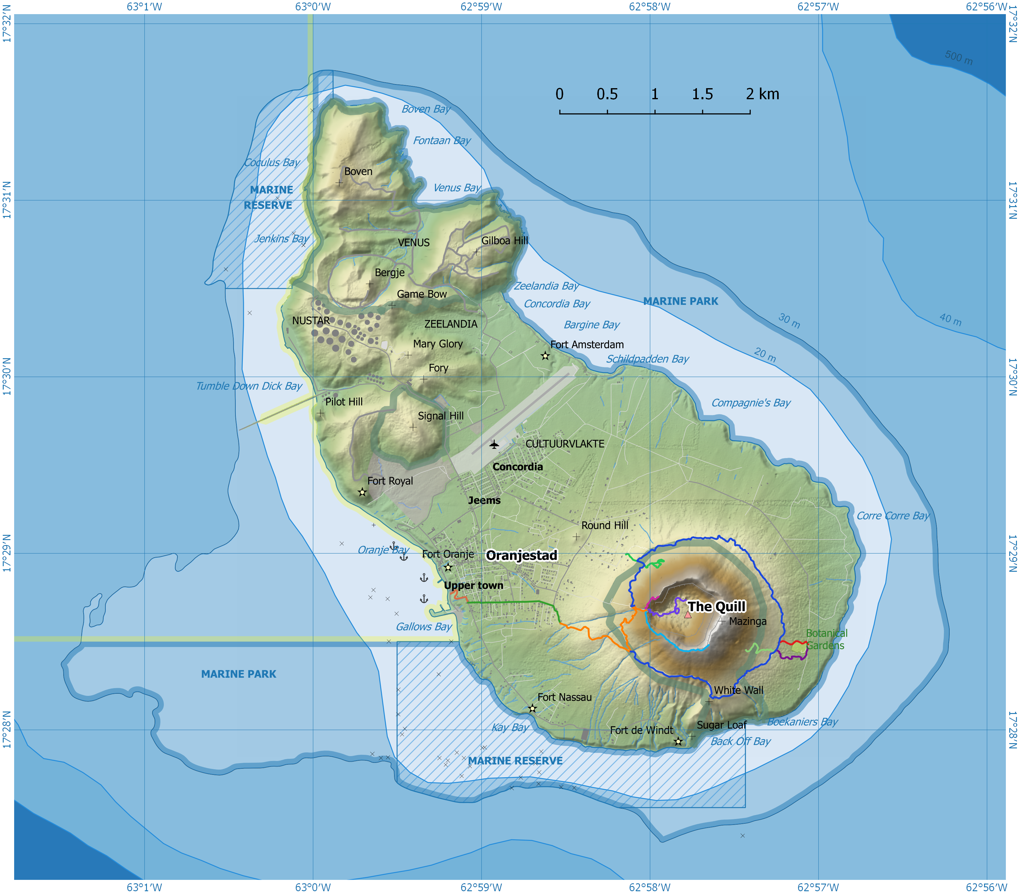
STENAPA (an acronym for St. Eustatius National Parks) is the national parks organisation of Sint Eustatius, a small Dutch island in the Caribbean. The island is situated within the inner arc of the Leeward Island chain of the Lesser Antilles, West Indies. Sint Eustatius is south of the island of Saba and north of the island of Saint Kitts. The island of St. Eustatius is now part of the country of the Netherlands, as a '' bijzondere gemeente'' or "special municipality". STENAPA is a non-profit, non-governmental foundation (in Dutch a ''stichting'') which was founded in 1988, and registered in 1995. The function of this foundation is environmental protection. STENAPA currently manages the National Marine Park, the Quill / Boven National Park, and the Botanical Garden. STENAPA is one of the members of the Dutch Caribbean Nature Alliance. The headquarters, the National Parks Office and Visitor Centre, is situated next to the harbour in Lower Town, which is the waterfront pa ... [...More Info...] [...Related Items...] OR: [Wikipedia] [Google] [Baidu] |
Sint Eustatius
Sint Eustatius, known locally as Statia, is an island in the Caribbean. It is a Caribbean Netherlands, special municipality (officially "Public body (Netherlands), public body") of the Netherlands. The island is in the northern Leeward Islands, southeast of the Virgin Islands. Sint Eustatius is immediately to the northwest of Saint Kitts and southeast of Saba (island), Saba. The regional capital is Oranjestad, Sint Eustatius, Oranjestad. The island has an area of . Travelers to the island by air arrive through F. D. Roosevelt Airport. Formerly part of the Netherlands Antilles, Sint Eustatius Dissolution of the Netherlands Antilles, became a public body of the Netherlands in 2010. It is part of the Dutch Caribbean, which consists of Aruba, Bonaire, Curaçao, Saba (island), Saba, Sint Eustatius, and Sint Maarten. Together with Bonaire and Saba, it forms the BES Islands, also referred to as the Caribbean Netherlands. Etymology The island's name, Sint Eustatius, is Dutch for Sa ... [...More Info...] [...Related Items...] OR: [Wikipedia] [Google] [Baidu] |
The Quill (volcano)
The Quill ( ), also known as Mount Mazinga, is a stratovolcano located on the island of Sint Eustatius in the Caribbean Netherlands. The summit elevation of above sea level makes it the second highest mountain in the Netherlands. The name ''Quill'' originates from the Dutch term ''kuil'' (), meaning 'pit' or 'hole', which was used originally with reference to the volcanic crater. The Quill was designated as a national park by the government of the Netherlands Antilles in 1998. Quill/Boven National Park is administered by the Sint Eustatius National Parks Foundation, STENAPA, which maintains a number of trails for hikers. The Quill formed between 22,000 and 32,000 years ago to the southeast of Sint Eustatius (Statia) in the West Indies. Pyroclastic flows during the initial eruption joined The Quill with what is now the rest of Sint Eustatius. The last known eruption, as determined by radiocarbon dating, occurred about 1,600 years ago. The volcano had a VEI of 4 in the eru ... [...More Info...] [...Related Items...] OR: [Wikipedia] [Google] [Baidu] |
Quill/Boven National Park
The Quill/Boven National Park comprises two separated sections of protected land at opposite ends of the island of Sint Eustatius in the Dutch Caribbean, maintained by the St. Eustatius National Parks Foundation (STENAPA). Both parts of the park have been identified by BirdLife International as Important Bird Areas (IBAs) because they support populations of several threatened or restricted-range bird species. The Boven IBA is a 1,016 ha peninsula of dry, rocky hills lying at the north-western end of the island. Its birds include a nesting colony of 100–200 red-billed tropicbirds, as well as resident green-throated caribs, Caribbean elaenias, pearly-eyed thrashers and lesser Antillean bullfinches. The Quill (volcano), The Quill IBA is a 470 ha site at the south-eastern end of Sint Eustatius; it is dominated by a 600 m high stratovolcano vegetated with shrubland and, within the caldera, tropical semi-evergreen forest. Additional resident birds include bridled ... [...More Info...] [...Related Items...] OR: [Wikipedia] [Google] [Baidu] |
Dutch Caribbean Nature Alliance
The Dutch Caribbean Nature Alliance (DCNA) is a regional partnership of conservation organisations, including the national parks on the six islands of the Dutch Caribbean (Aruba, Bonaire, Curaçao, Saba, St. Eustatius and St. Maarten) and is intended to support and strengthen the nature on the islands. The purpose of DCNA is to protect the extensive biological resources and promote sustainable development of the natural resources of these islands, both on land and at sea. To do so, DCNA is developing sustainable funding sources such as a trust fund, building capacity through training workshops and promoting the overwhelmingly beautiful and unique nature, ranging from exuberant rainforest to coral reefs and pearl white sand dunes. The extensive biological resources are the basis of one of the main sources of income on the islands: nature tourism. DCNA not only focuses on the sustainable management of existing protected areas, but also to increase awareness and knowledge of the ... [...More Info...] [...Related Items...] OR: [Wikipedia] [Google] [Baidu] |
1988 Establishments In The Netherlands Antilles
1988 was a crucial year in the early history of the Internet—it was the year of the first well-known computer virus, the Morris worm, 1988 Internet worm. The first permanent intercontinental Internet link was made between the United States (National Science Foundation Network) and Europe (Nordunet) as well as the first Internet-based chat protocol, Internet Relay Chat. The concept of the World Wide Web was first discussed at CERN in 1988. The Soviet Union began its major deconstructing towards a mixed economy at the beginning of 1988 and began its Dissolution of the Soviet Union, gradual dissolution. The Iron Curtain began to disintegrate in 1988 as People's Republic of Hungary, Hungary began allowing freer travel to the Western world. The first extrasolar planet, Gamma Cephei Ab (confirmed in 2003), was detected this year and the World Health Organization began its mission to Eradication of polio, eradicate polio. Global warming also began to emerge as a more significant ... [...More Info...] [...Related Items...] OR: [Wikipedia] [Google] [Baidu] |
Nature Conservation Organizations Based In North America
Nature is an inherent character or constitution, particularly of the ecosphere or the universe as a whole. In this general sense nature refers to the laws, elements and phenomena of the physical world, including life. Although humans are part of nature, human activity or humans as a whole are often described as at times at odds, or outright separate and even superior to nature. During the advent of modern scientific method in the last several centuries, nature became the passive reality, organized and moved by divine laws. With the Industrial Revolution, nature increasingly became seen as the part of reality deprived from intentional intervention: it was hence considered as sacred by some traditions (Rousseau, American transcendentalism) or a mere decorum for divine providence or human history (Hegel, Marx). However, a vitalist vision of nature, closer to the pre-Socratic one, got reborn at the same time, especially after Charles Darwin. Within the various uses of the word t ... [...More Info...] [...Related Items...] OR: [Wikipedia] [Google] [Baidu] |
National Park Administrators
National may refer to: Common uses * Nation or country ** Nationality – a ''national'' is a person who is subject to a nation, regardless of whether the person has full rights as a citizen Places in the United States * National, Maryland, census-designated place * National, Nevada, ghost town * National, Utah, ghost town * National, West Virginia, unincorporated community Commerce * National (brand), a brand name of electronic goods from Panasonic * National Benzole (or simply known as National), former petrol station chain in the UK, merged with BP * National Book Store, a bookstore and office supplies chain in the Philippines * National Car Rental, an American rental car company * National Energy Systems, a former name of Eco Marine Power * National Entertainment Commission, a former name of the Media Rating Council * National Motor Vehicle Company, Indianapolis, Indiana, USA 1900–1924 * National Radio Company, Malden, Massachusetts, USA 1914–1991 * National Supermarket ... [...More Info...] [...Related Items...] OR: [Wikipedia] [Google] [Baidu] |
Antigonon Leptopus
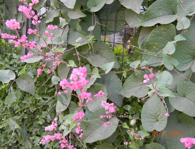
''Antigonon leptopus'' is a species of perennial vine in the buckwheat family commonly known as coral vine or queen's wreath. This clambering vine is characterized by showy, usually pink flowers that can bloom throughout the year and large, heart-shaped leaves. ''A. leptopus'' is native to the Pacific and Atlantic coastal plains of Mexico, but also occurs as a roadside weed from Mexico south to Central America. It is widely introduced and invasive throughout tropical regions of the world, including in the south and eastern United States, the West Indies, South America, and the Old World tropics of Asia and Africa. This species is utilized for its edible tubers and seeds, but also for its horticultural properties as an ornamental vine in warmer parts of the world. Description ''Antigonon leptopus'' is a fast-growing climbing vine that holds on via tendrils, and is able to reach over 7 metres in length. It has cordate (heart-shaped), sometimes triangular leaves 25 to 75 m ... [...More Info...] [...Related Items...] OR: [Wikipedia] [Google] [Baidu] |
Botanical Garden
A botanical garden or botanic gardenThe terms ''botanic'' and ''botanical'' and ''garden'' or ''gardens'' are used more-or-less interchangeably, although the word ''botanic'' is generally reserved for the earlier, more traditional gardens. is a garden with a documented collection of living plants for the purpose of scientific research, conservation, display, and education. It is their mandate as a botanical garden that plants are labelled with their botanical names. It may contain specialist plant collections such as cactus, cacti and other succulent plants, herb gardens, plants from particular parts of the world, and so on; there may be greenhouse, glasshouses or shadehouses, again with special collections such as tropical plants, alpine plants, or other exotic plants that are not native to that region. Most are at least partly open to the public, and may offer guided tours, public programming such as workshops, courses, educational displays, art exhibitions, book rooms, op ... [...More Info...] [...Related Items...] OR: [Wikipedia] [Google] [Baidu] |


