|
River Doon
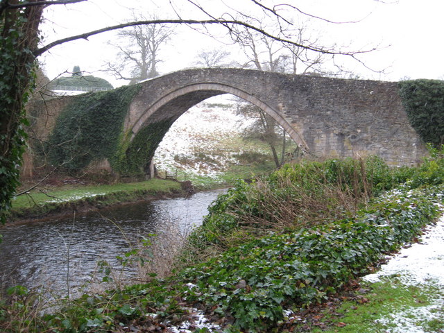
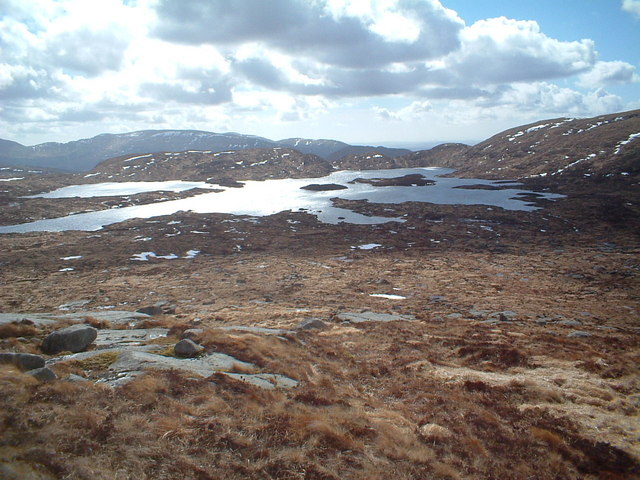
The River Doon ( gd, Abhainn Dhùin, ) is a river in Ayrshire, Scotland. Its course is generally north-westerly, passing near to the town of Dalmellington, and through the villages of Patna, Dalrymple, and Alloway, birthplace of Robert Burns. The source of the Doon is Loch Enoch, high in the Galloway Hills. In the 1930s the Loch Doon was dammed to provide water to the Galloway Hydro Electric Scheme, today operated by Scottish Power Scottish Power is a vertically integrated energy company based in Glasgow, Scotland. It is a subsidiary of Spanish utility firm Iberdrola. ScottishPower is the distribution network operator for Central and Southern Scotland, Merseyside, North .... The Doon is mentioned in Burns' classic narrative poem " Tam o' Shanter", along with the Brig o' Doon, which spans across the river, just outside Alloway. The river is also the major setting for his lesser-known poem "The Banks O' Doon". External linksRiver Doon at the Ayrshire Rivers Trust ... [...More Info...] [...Related Items...] OR: [Wikipedia] [Google] [Baidu] |
Ayrshire
Ayrshire ( gd, Siorrachd Inbhir Àir, ) is a historic county and registration county in south-west Scotland, located on the shores of the Firth of Clyde. Its principal towns include Ayr, Kilmarnock and Irvine and it borders the counties of Renfrewshire and Lanarkshire to the north-east, Dumfriesshire to the south-east, and Kirkcudbrightshire and Wigtownshire to the south. Like many other counties of Scotland it currently has no administrative function, instead being sub-divided into the council areas of North Ayrshire, South Ayrshire and East Ayrshire. It has a population of approximately 366,800. The electoral and valuation area named Ayrshire covers the three council areas of South Ayrshire, East Ayrshire and North Ayrshire, therefore including the Isle of Arran, Great Cumbrae and Little Cumbrae. These three islands are part of the historic County of Bute and are sometimes included when the term ''Ayrshire'' is applied to the region. The same area is known as ''Ayrshire a ... [...More Info...] [...Related Items...] OR: [Wikipedia] [Google] [Baidu] |
Scotland
Scotland (, ) is a country that is part of the United Kingdom. Covering the northern third of the island of Great Britain, mainland Scotland has a border with England to the southeast and is otherwise surrounded by the Atlantic Ocean to the north and west, the North Sea to the northeast and east, and the Irish Sea to the south. It also contains more than 790 islands, principally in the archipelagos of the Hebrides and the Northern Isles. Most of the population, including the capital Edinburgh, is concentrated in the Central Belt—the plain between the Scottish Highlands and the Southern Uplands—in the Scottish Lowlands. Scotland is divided into 32 administrative subdivisions or local authorities, known as council areas. Glasgow City is the largest council area in terms of population, with Highland being the largest in terms of area. Limited self-governing power, covering matters such as education, social services and roads and transportation, is devolved from the Scott ... [...More Info...] [...Related Items...] OR: [Wikipedia] [Google] [Baidu] |
Dalmellington
Dalmellington ( sco, Dawmellinton, gd, Dail M'Fhaolain) is a market town and civil parish in East Ayrshire, Scotland. In 2001 the village had a population of 1,407. The town owes its origins to the fault line separating the Southern Uplands of Scotland from the Central Lowlands. Dalmellington sits at the issue of a river from the uplands into Dalmellington Moss plain. The town has a history as a rest area, market town, weaving centre and mining village. The Chalmerston open cast coal mine to the north of the village covered some 742 hectares, but the operations have now ceased and the first phase of the site restoration has been completed. The town used to have a working museum to record the history of the area, but it was closed in January 2017. There are many Sites of Special Scientific Interest around Dalmellington, the most notable being the nearby Loch Doon. Selection of local views The Scottish Dark Sky Observatory was located near Dalmellington and is within the north ... [...More Info...] [...Related Items...] OR: [Wikipedia] [Google] [Baidu] |
Patna, Scotland
Patna is a village in East Ayrshire, Scotland, straddling the traditional districts of Carrick and Kyle. It was established in 1802 by William Fullarton to provide housing for workers on the coalfields of his estate. Fullarton's father had worked as an employee of the British East India Company, and the town is named after the city of Patna in the Bihar province of India. Patna lies southeast of Ayr on the A713 to Castle Douglas at its junction with the road to Kirkmichael just north of Dalmellington. Patna lies between the villages of Polnessan and Waterside, and the River Doon flows through it. The Patna Campus was completed in 2012 and hosts Patna Primary School (a non-denominational school. Head Teacher - C. McPhail), St Xavier's Primary School (a Catholic primary school which was formerly located in Waterside but has been moved into Patna, and is also attended by pupils from Dalmellington, Bellsbank, Maybole and surrounding areas. Head Teacher - A. Rooney) A secondary ... [...More Info...] [...Related Items...] OR: [Wikipedia] [Google] [Baidu] |
Dalrymple, East Ayrshire
Dalrymple ( sco, Drumple) is a village and parish in East Ayrshire, Scotland, lying in the Doon Valley on the north bank of the River Doon. The population is around 1,347. The name Dalrymple comes from Gaelic meaning "flat field of the crooked pool or river". The village is relatively modern, although the parish and church of Dalrymple are older. When the community was first established around 1800, there were two streets, Main Street and Garden Street. The village grew slowly until the late 20th century, when council housing was built to house families from coal-mining villages in the area that were suffering an economic decline. It has about 1,000 houses. There are two pubs, The Kirkton Inn; a hotel with self-catering studios, restaurant, a hairdresser, shops, a chemist and post office, as well as a primary school. The village is in the catchment area for high schools in Ayr, Maybole and Dalmellington. Ayr is north of Dalrymple by road. The River Doon remains the boundary o ... [...More Info...] [...Related Items...] OR: [Wikipedia] [Google] [Baidu] |
Alloway
Alloway ( gd, Allmhaigh, ) is a village in South Ayrshire, Scotland, located on the River Doon. It is best known as the birthplace of Robert Burns and the setting for his poem "Tam o' Shanter". Tobias Bachope, the mason responsible for the construction of Hopetoun House, Craigiehall, and Kinross House, also hailed from Alloway. Some historic parts of the village make up a conservation area. The village and surrounding areas were incorporated into the Royal Burgh of Ayr in 1935, and the extended village is now a suburb of Ayr. Robert Burns The birthplace of Robert Burns, known as "Burns Cottage", is located in Alloway, now adjacent to a museum containing original manuscripts of his poetry. A nineteenth century memorial to Burns, designed by Thomas Hamilton, is located at the foot of the village next to the present church. The nearby, ruined Alloway Auld Kirk and the Brig o' Doon are featured in the poem '' Tam o' Shanter'', and are presently tourist attractions. Burns's fat ... [...More Info...] [...Related Items...] OR: [Wikipedia] [Google] [Baidu] |
Robert Burns
Robert Burns (25 January 175921 July 1796), also known familiarly as Rabbie Burns, was a Scottish poet and lyricist. He is widely regarded as the national poet of Scotland and is celebrated worldwide. He is the best known of the poets who have written in the Scots language, although much of his writing is in a "light Scots dialect" of English, accessible to an audience beyond Scotland. He also wrote in standard English, and in these writings his political or civil commentary is often at its bluntest. He is regarded as a pioneer of the Romantic movement, and after his death he became a great source of inspiration to the founders of both liberalism and socialism, and a cultural icon in Scotland and among the Scottish diaspora around the world. Celebration of his life and work became almost a national charismatic cult during the 19th and 20th centuries, and his influence has long been strong on Scottish literature. In 2009 he was chosen as the greatest Scot by the Scottish pub ... [...More Info...] [...Related Items...] OR: [Wikipedia] [Google] [Baidu] |
Loch Enoch
Loch Enoch is a multi-basin freshwater loch in Galloway, to the east of Merrick and south of Mullwharchar. The loch is situated in a granite basin and has several small islands and some beaches on its shore. The sharp granite sand of these beaches was collected and sold for sharpening knives and scythes. The catchment area's vegetation is mainly Purple Moor Grass and Heather. The loch's outflow supplies Loch Doon and the River Doon, both in Ayrshire. Acidification By 1800 the water of Loch Enoch had already become acidic. J. McBain in his 1929 book ''The Merrick and the Neighbouring Hills. Tramps by Hill, Stream and Loch'' describes a trout that 'bore the unmistakable marks of a Loch Enoch trout, i.e. it was minus the lower half of its tail and part of its ventral fins'. McBain writes that the last recorded trout caught was in 1899. Since 1940 the loch became more acidic due to industrial emissions and in the 1950s it completely lost its fish population. In 1994 it was rest ... [...More Info...] [...Related Items...] OR: [Wikipedia] [Google] [Baidu] |
Galloway Hills
The Galloway Hills are part of the Southern Uplands of Scotland, and form the northern boundary of western Galloway. They lie within the bounds of the Galloway Forest Park, an area of some of largely uninhabited wild land, managed by Forestry and Land Scotland. The unusual place names reflect a mixture of the Old Norse and Scottish Gaelic languages and hint at the range of influences which have acted on society within the area over the centuries. Location The location of Galloway has been described as follows, "Galloway is contained by sea to the west ( North Channel) and south (Solway Firth), the "Galloway Hills" to the north, and the River Nith to the east". So if we were to say "The hills of Galloway" we would be including all the hills within this area; but as the first sentence implies, the "Galloway Hills" is usually taken to mean a collection of ranges which lie mainly south of Loch Doon and which are not constrained by political boundaries. The boundary between Dumfri ... [...More Info...] [...Related Items...] OR: [Wikipedia] [Google] [Baidu] |
Galloway Hydro Electric Scheme
The Galloway hydro-electric power scheme is a network of dams and hydro-electric power stations in Galloway, south west Scotland. It was built between 1930 and 1936. The generating stations draw water from the River Ken, River Dee and River Doon through reservoirs at Loch Doon, Kendoon, Carsfad, Clatteringshaws, and Tongland. The unusual modernist stations were designed by Scottish civil engineer, Sir Alexander Gibb. The scheme, which is today operated by Drax, can produce a total peak power of around 106 megawatts. History The scheme was authorized by the Galloway Water Power Act on 10 May 1929, by which the Galloway Water Power Company was incorporated. Chairman of the board was former colonial administrator Lord Meston. Also on the board was Robert Brand, managing director of the project's underwriter, Lazard Brothers and Company. Design was carried out by civil engineers Sir Alexander Gibb and Partners along with electrical engineer, William McLellan of Merz & Mc ... [...More Info...] [...Related Items...] OR: [Wikipedia] [Google] [Baidu] |
Scottish Power
Scottish Power is a vertically integrated energy company based in Glasgow, Scotland. It is a subsidiary of Spanish utility firm Iberdrola. ScottishPower is the distribution network operator for Central and Southern Scotland, Merseyside, North Wales and parts of Cheshire and Shropshire. It is also the transmission owner for the south of Scotland. The company also supplies electricity and gas to homes and businesses around the United Kingdom and generates power for supply to the grid. It owned PPM Energy in the United States which has now been folded into Avangrid. Not to be confused with Scottish Power Company Limited (1909–48). History Foundation ScottishPower was formed in 1990, in preparation for the privatisation of the previously state-owned Scottish electricity industry the following year. Previously the UK government had privatised the English and Welsh electricity industry by splitting the market into 12 regional electricity companies (RECs) and two power gene ... [...More Info...] [...Related Items...] OR: [Wikipedia] [Google] [Baidu] |


.jpg)