|
Rheiderland
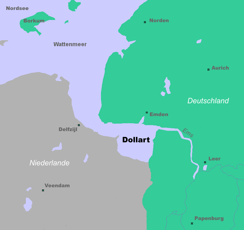
The Rheiderland (; ) is a region of Germany and the Netherlands between the River Ems and the Bay of Dollart. The German part of the Rheiderland lies in East Frisia, west of the Ems. The Dutch part (written: ''Reiderland'') lies in the Dutch province of Groningen and is mostly part of Oldambt. The Rheiderland is one of the four historic regions on the mainland in the district of Leer; the others being the Overledingerland, the Moormerland and the Lengenerland. Nature The Rheiderland consists largely of marshland (polder) and is as flat as the rest of East Frisia, but there are fewer trees. As a result the view is generally clear as far as the horizon. Along the River Ems are the historic river marshes, down to 1.50 metres below sea level. Numerous birds breed on the damp and wet meadows including the peewit, black-tailed godwit and redshank. In winter up to 120,000 wild geese forage here (especially the greater white-fronted goose, barnacle goose and greylag goose). The g ... [...More Info...] [...Related Items...] OR: [Wikipedia] [Google] [Baidu] |
Jemgum
Jemgum is a municipality in the Leer district, in the northwest of Lower Saxony, Germany. The area is known as ''Rheiderland'' (German) or ''Reiderland'' (Dutch). Rheiderland is located in East Friesland. History Jemgum was the site of the Battle of Jemmingen on 21 July 1568, an early event of the Eighty Years' War, in which a Spanish army defeated a Dutch Rebel army under Louis of Nassau Louis of Nassau (Dutch: Lodewijk van Nassau, 10 January 1538 – 14 April 1574) was a Dutch nobleman, the third son of William I, Count of Nassau-Siegen and Juliana of Stolberg, and the younger brother of Prince William the Silent, William .... References Populated places established in the 8th century Towns and villages in East Frisia Leer (district) Rheiderland {{Leer-geo-stub ... [...More Info...] [...Related Items...] OR: [Wikipedia] [Google] [Baidu] |
East Frisia
East Frisia () or East Friesland (; ; ; ) is a historic region in the northwest of Lower Saxony, Germany. It is primarily located on the western half of the East Frisia (peninsula), East Frisian peninsula, to the east of West Frisia and to the west of Friesland (district), Landkreis Friesland. Administratively, East Frisia consists of the districts Aurich (district), Aurich, Leer (district), Leer and Wittmund (district), Wittmund and the city of Emden. It has a population of approximately 469,000 people and an area of . There is a chain of islands off the coast, called the East Frisian Islands (). From west to east, these islands are Borkum, Juist, Norderney, Baltrum, Langeoog and Spiekeroog. History The geographical region of East Frisia was inhabited in Paleolithic times by reindeer hunters of the Hamburg culture. Later there were Mesolithic and Neolithic settlements of various cultures. The period after prehistory can only be reconstructed from archaeological evidence. A ... [...More Info...] [...Related Items...] OR: [Wikipedia] [Google] [Baidu] |
Bunde, Germany
Bunde () is a municipal district in East Frisia, in Lower Saxony, Germany, about south of Emden, Germany, and east of Groningen, Netherlands. It lies on the southern tip of the Dollart, a bay of the North Sea between Germany and the Netherlands, and has a land border with the Netherlands. Bunde is among the smaller districts of East Frisia, with a population of 7,607 (as of 2015). About half live in the town of Bunde itself. The district's population density is comparatively low at , compared with for Germany as a whole. In the 17th and 18th centuries, sizeable areas of the district were wrested from the sea by the creation of polders. Bunde's economy centers on agriculture and tourism. The community has been officially recognized as a resort town since 1998. Many of the town's residents commute to jobs elsewhere, notably in Leer, about to the east. Residents include a number of Dutch nationals, most of whom commute to jobs in the Netherlands. The town's cultural artifacts ... [...More Info...] [...Related Items...] OR: [Wikipedia] [Google] [Baidu] |
Reiderland Kaart
Reiderland () is a former Municipalities of the Netherlands, municipality in the province Groningen (province), Groningen in the northeastern Netherlands, which was founded in 1990 during a large municipal reorganisation. The former municipalities Finsterwolde and Bad Nieuweschans were abolished and added to Beerta. In 1992, the new municipality was given its current name. In 2010 it joined in the municipality Oldambt (municipality), Oldambt. Politics Reiderland was one of the few municipalities in the Netherlands that still had Communism, communist councillors after the dissolution of the Communist Party of the Netherlands in 1989. (As of 2006, it was one of only four Dutch municipalities to have any, the other three being Heiloo, Scheemda and Lemsterland.) The New Communist Party of the Netherlands was in fact the largest party in Reiderland from 1990 to 1998 and again from 2002 to 2006. Finsterwolde and Beerta, which was the only town in the Netherlands that ever had a communis ... [...More Info...] [...Related Items...] OR: [Wikipedia] [Google] [Baidu] |
Dollart
The Dollart (German name, ) or Dollard (Dutch name, ) is a bay in the Wadden Sea between the northern Netherlands and Germany, on the west side of the estuary of the Ems river. Most of it dries at low tide. Many water birds feed there. Gaining from and losing to the sea According to legend, the Dollart Bay was created by a catastrophic storm surge in 1277, covering the district of Rheiderland and large parts of the Oldambt district. The flood was rumoured to have caused 80,000 deaths. The story, however, is not true and based on legend instead of facts. The Dollart was created as a slow inundation over many centuries which accumulated in a storm surge in 1509. The 1509 surge extended the Dollart, and flooded 30 more villages, and by 1520 the Dollart had its largest extension. Between the 16th and the 20th centuries, two thirds of the drowned area was reclaimed. Nowadays the unembanked forelands have been declared world natural heritage, as they are a paradise for all k ... [...More Info...] [...Related Items...] OR: [Wikipedia] [Google] [Baidu] |
Barnacle Goose
The barnacle goose (''Branta leucopsis'') is a species of goose that belongs to the genus ''Branta'' of black geese, which contains species with extensive black in the plumage, distinguishing them from the grey ''Anser (genus), Anser'' species. Despite its superficial similarity to the brant goose, genetic analysis has shown its closest relative is the cackling goose. Taxonomy and naming The barnacle goose was first Biological classification, classified taxonomically by Johann Matthäus Bechstein in 1803. ''Branta'' is a Latinised form of Old Norse ''Brandgás'', "burnt [black] goose" and the specific epithet is from the Ancient Greek ''leukos'' "white", and ''opsis'' "faced". In the mediaeval period, the barnacle goose and the similar brant goose were not distinguished, and Barnacle goose myth, were formerly believed to spawn from the goose barnacle. This gave rise to the English name of the barnacle goose and the scientific name of the brant goose. The barnacle myth can be date ... [...More Info...] [...Related Items...] OR: [Wikipedia] [Google] [Baidu] |
Netherlands
, Terminology of the Low Countries, informally Holland, is a country in Northwestern Europe, with Caribbean Netherlands, overseas territories in the Caribbean. It is the largest of the four constituent countries of the Kingdom of the Netherlands. The Netherlands consists of Provinces of the Netherlands, twelve provinces; it borders Germany to the east and Belgium to the south, with a North Sea coastline to the north and west. It shares Maritime boundary, maritime borders with the United Kingdom, Germany, and Belgium. The official language is Dutch language, Dutch, with West Frisian language, West Frisian as a secondary official language in the province of Friesland. Dutch, English_language, English, and Papiamento are official in the Caribbean Netherlands, Caribbean territories. The people who are from the Netherlands is often referred to as Dutch people, Dutch Ethnicity, Ethnicity group, not to be confused by the language. ''Netherlands'' literally means "lower countries" i ... [...More Info...] [...Related Items...] OR: [Wikipedia] [Google] [Baidu] |
Wymeer
Wymeer is a village in the municipality of Bunde in the district of Leer in Lower Saxony, Germany Germany, officially the Federal Republic of Germany, is a country in Central Europe. It lies between the Baltic Sea and the North Sea to the north and the Alps to the south. Its sixteen States of Germany, constituent states have a total popu .... Municipality of Bunde. Retrieved 25 May 2016. References Villages in Lower Saxony {{LowerSaxony-geo-stub ...[...More Info...] [...Related Items...] OR: [Wikipedia] [Google] [Baidu] |
Bourtanger Moor
The Bourtanger Moor (Dutch: ''Bourtangerveen/Bourtangermoeras'', German: ''Bourtanger Moor'', Low Saxon: ''Boertanger Moor'') was a bog in eastern parts in the Dutch provinces of Drenthe and Groningen and the bordering German districts of Bentheim and Emsland. A remaining stretch on the border between Drenthe and the districts Emsland and Betheim is now a nature reserve, the Internationaler Naturpark Bourtanger Moor-Bargerveen. Shape and size The Bourtange Swamp had the shape of a V. The western leg covered the valley of the Hunze and ranged towards the city of Groningen. The western part was bordered by the Hondsrug. The eastern leg was located in the valley of the Ems. Between these two legs lies Westerwolde. At its greatest extent the swamp was about 3000 km2. History The swamp arose around 5000 BC. The area was already inhabited before this happened, as shown by archeological finds such as the one at Hoetsmansmeer in Groningen. These finds are attributed to nomads f ... [...More Info...] [...Related Items...] OR: [Wikipedia] [Google] [Baidu] |
Moorland
Moorland or moor is a type of Habitat (ecology), habitat found in upland (geology), upland areas in temperate grasslands, savannas, and shrublands and the biomes of montane grasslands and shrublands, characterised by low-growing vegetation on Soil pH, acidic soils. Moorland today generally means uncultivated hill land (such as Dartmoor in South West England), but also includes low-lying wetlands (such as Sedgemoor, also South West England). It is closely related to heath, although experts disagree on the exact distinction between these types of vegetation. Generally, moor refers to Highland (geography), highland and high rainfall areas, while heath refers to lowland zones which are more likely to be the result of human activity. Moorland habitats are found mainly in Tropics, tropical Africa, Northern Europe, northern and western Europe, and South America. Most of the world's moorlands are diverse ecosystems. In the extensive moorlands of the tropics, biodiversity can be extremely ... [...More Info...] [...Related Items...] OR: [Wikipedia] [Google] [Baidu] |


