|
Reull Vallis
Reull Vallis is a valley on Mars that appears to have been carved by water. It runs westward into Hellas Planitia. It is named after the Gaelic word for planet. It is found in the Hellas quadrangle. Lineated Floor Deposits On the floors of some channels are features called lineated floor deposits. They are ridged and grooved materials that seem to deflect around obstacles. They are believed to be ice-rich. Some glaciers on the Earth show such features. Lineated floor deposits may be related to lobate debris aprons, which have been proven to contain large amounts of ice. Reull Vallis, as pictured below, displays these deposits.http://themis.asu.edu.zoom-20070716a Gallery Image:Reull Vallis.JPG, Drainage features in Reull Vallis, as seen by THEMIS. Click on image to see relationship of Reull Vallis to other features. File:Reull Vallis lineated deposits.jpg, Reull Vallis with lineated floor deposits, as seen by THEMIS. Click on image to see relationship to other feature ... [...More Info...] [...Related Items...] OR: [Wikipedia] [Google] [Baidu] |
Mars
Mars is the fourth planet from the Sun and the second-smallest planet in the Solar System, only being larger than Mercury. In the English language, Mars is named for the Roman god of war. Mars is a terrestrial planet with a thin atmosphere (less than 1% that of Earth's), and has a crust primarily composed of elements similar to Earth's crust, as well as a core made of iron and nickel. Mars has surface features such as impact craters, valleys, dunes and polar ice caps. It has two small and irregularly shaped moons, Phobos and Deimos. Some of the most notable surface features on Mars include Olympus Mons, the largest volcano and highest known mountain in the Solar System and Valles Marineris, one of the largest canyons in the Solar System. The Borealis basin in the Northern Hemisphere covers approximately 40% of the planet and may be a large impact feature. Days and seasons on Mars are comparable to those of Earth, as the planets have a similar rotation period a ... [...More Info...] [...Related Items...] OR: [Wikipedia] [Google] [Baidu] |
Hellas Planitia
Hellas Planitia is a plain located within the huge, roughly circular impact basin Hellas located in the southern hemisphere of the planet Mars. Hellas is the third- or fourth-largest known impact crater in the Solar System. The basin floor is about deep, deeper than the Moon's South Pole-Aitken basin, and extends about east to west.The part below zero datum, see Geography of Mars#Zero elevation It is centered at Hellas Planitia spans the boundary between the Hellas quadrangle and the Noachis quadrangle. Description With a diameter of about , it is the largest unambiguous impact structure on the planet; the obscured Utopia Planitia is slightly larger (the Borealis Basin, if it proves to be an impact crater, is considerably larger). Hellas Planitia is thought to have been formed during the Late Heavy Bombardment period of the Solar System, approximately 4.1 to 3.8 billion years ago, when a protoplanet or large asteroid hit the surface. The altitude difference betwe ... [...More Info...] [...Related Items...] OR: [Wikipedia] [Google] [Baidu] |
Goidelic Languages
The Goidelic or Gaelic languages ( ga, teangacha Gaelacha; gd, cànanan Goidhealach; gv, çhengaghyn Gaelgagh) form one of the two groups of Insular Celtic languages, the other being the Brittonic languages. Goidelic languages historically formed a dialect continuum stretching from Ireland through the Isle of Man to Scotland. There are three modern Goidelic languages: Irish ('), Scottish Gaelic ('), and Manx ('). Manx died out as a first language in the 20th century but has since been revived to some degree. Nomenclature ''Gaelic'', by itself, is sometimes used to refer to Scottish Gaelic, especially in Scotland, and so it is ambiguous. Irish and Manx are sometimes referred to as Irish Gaelic and Manx Gaelic (as they are Goidelic or Gaelic languages), but the use of the word "Gaelic" is unnecessary because the terms Irish and Manx, when used to denote languages, always refer to those languages. This is in contrast to Scottish Gaelic, for which "Gaelic" distinguis ... [...More Info...] [...Related Items...] OR: [Wikipedia] [Google] [Baidu] |
Planet
A planet is a large, rounded astronomical body that is neither a star nor its remnant. The best available theory of planet formation is the nebular hypothesis, which posits that an interstellar cloud collapses out of a nebula to create a young protostar orbited by a protoplanetary disk. Planets grow in this disk by the gradual accumulation of material driven by gravity, a process called accretion. The Solar System has at least eight planets: the terrestrial planets Mercury, Venus, Earth and Mars, and the giant planets Jupiter, Saturn, Uranus and Neptune. These planets each rotate around an axis tilted with respect to its orbital pole. All of them possess an atmosphere, although that of Mercury is tenuous, and some share such features as ice caps, seasons, volcanism, hurricanes, tectonics, and even hydrology. Apart from Venus and Mars, the Solar System planets generate magnetic fields, and all except Venus and Mercury have natural satellites. The giant pla ... [...More Info...] [...Related Items...] OR: [Wikipedia] [Google] [Baidu] |
Hellas Quadrangle
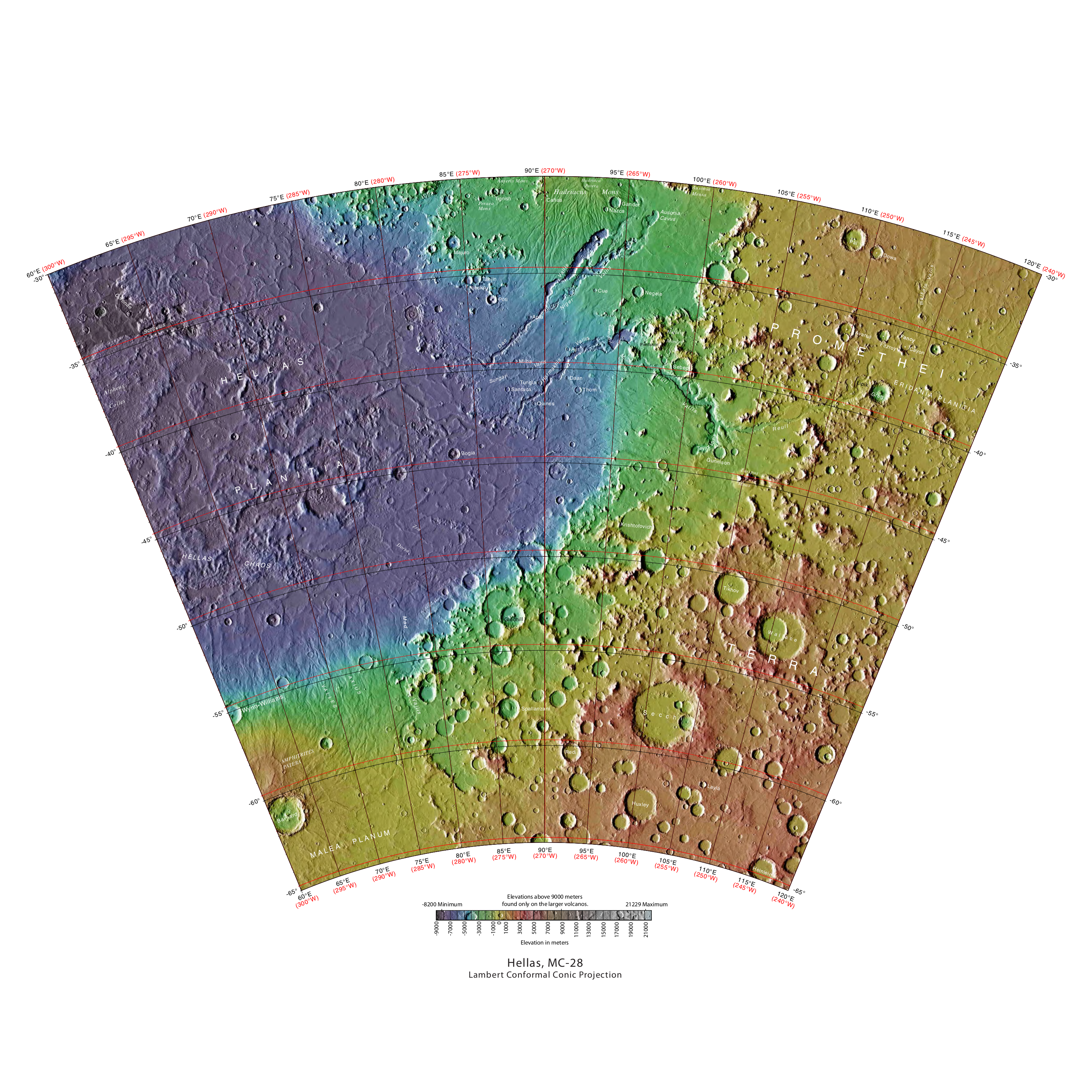
The Hellas quadrangle (geography), quadrangle is one of a series of list of quadrangles on Mars, 30 quadrangle maps of Mars used by the United States Geological Survey (USGS) Astrogeology Research Program. The Hellas quadrangle is also referred to as MC-28 (Mars Chart-28). The Hellas quadrangle covers the area from 240° to 300° west longitude and 30° to 65° south latitude on the planet Mars. Within the Hellas quadrangle lies the classic features Hellas Planitia and Promethei Terra. Many interesting and mysterious features have been discovered in the Hellas quadrangle, including the giant river valleys Dao Vallis, Niger Vallis, Harmakhis, and Reull Vallis—all of which may have contributed water to a lake in the Hellas basin in the distant past. Many places in the Hellas quadrangle show signs of ice in the ground, especially places with glacier-like flow features. Hellas Basin The Hellas quadrangle contains part of the Hellas Basin, the largest known impact crater on the surfa ... [...More Info...] [...Related Items...] OR: [Wikipedia] [Google] [Baidu] |
Lobate Debris Apron
Lobate debris aprons (LDAs) are geological features on Mars, first seen by the Viking Orbiters, consisting of piles of rock debris below cliffs. These features have a convex topography and a gentle slope from cliffs or escarpments, which suggest flow away from the steep source cliff. In addition, lobate debris aprons can show surface lineations as do rock glaciers on the Earth. File:Wikictxp13clifflda.jpg, alt=Wide view of mesa with CTX showing Cliff face and location of lobate debris apron (LDA) Location is Ismenius Lacus quadrangle., Wide view of mesa with CTX showing cliff face and location of lobate debris apron (LDA) Location is Ismenius Lacus quadrangle. File:Wikifretesp 028313 2220cliff.jpg, Enlargement of previous CTX image of mesa This image shows the cliff face and detail in the LDA. Image taken with HiRISE under HiWish program. Location is Ismenius Lacus quadrangle. File:Wikildaf03 036777 2287.jpg, alt=Lobate debris aprons (LDAs) around a mesa, as seen by CTX. ... [...More Info...] [...Related Items...] OR: [Wikipedia] [Google] [Baidu] |
European Space Agency
, owners = , headquarters = Paris, Île-de-France, France , coordinates = , spaceport = Guiana Space Centre , seal = File:ESA emblem seal.png , seal_size = 130px , image = Views in the Main Control Room (12052189474).jpg , size = , caption = , acronym = , established = , employees = 2,200 , administrator = Director General Josef Aschbacher , budget = €7.2 billion (2022) , language = English and French (working languages) , website = , logo = European Space Agency logo.svg , logo_caption = Logo , image_caption = European Space Operations Centre (ESOC) Main Control Room The European Space Agency (ESA; french: Agence spatiale européenne , it, Agenzia Spaziale Europea, es, Agencia Espacial Europea ASE; german: Europäische Weltraumorganisation) is an intergovernmental organisation of 22 member states dedicated to the exploration of space. Established in 1975 and headquartered ... [...More Info...] [...Related Items...] OR: [Wikipedia] [Google] [Baidu] |
Thermal Emission Imaging System
The Thermal Emission Imaging System (THEMIS) is a camera on board the 2001 Mars Odyssey orbiter. It images Mars in the visible and infrared parts of the electromagnetic spectrum in order to determine the thermal properties of the surface and to refine the distribution of minerals on the surface of Mars as determined by the Thermal Emission Spectrometer (TES). Additionally, it helps scientists to understand how the mineralogy of Mars relates to its landforms, and it can be used to search for thermal hotspots in the Martian subsurface. THEMIS is managed from the Mars Space Flight Facility at Arizona State University and was built by the Santa Barbara Remote Sensing division of Raytheon Technologies Corporation, an American multinational conglomerate headquartered in Waltham, Massachusetts. The instrument is named after Themis, the goddess of justice in ancient Greek mythology. Infrared camera THEMIS detects thermal infrared energy emitted by the Martian surface at nin ... [...More Info...] [...Related Items...] OR: [Wikipedia] [Google] [Baidu] |
Fretted Terrain
Fretted terrain is a type of surface feature common to certain areas of Mars and was discovered in Mariner 9 images. It lies between two different types of terrain. The surface of Mars can be divided into two parts: low, young, uncratered plains that cover most of the northern hemisphere, and high-standing, old, heavily cratered areas that cover the southern and a small part of the northern hemisphere. Between these two zones is a region called the Martian dichotomy and parts of it contain fretted terrain. This terrain contains a complicated mix of cliffs, mesas, buttes, and straight-walled and sinuous canyons. It contains smooth, flat lowlands along with steep cliffs. The scarps or cliffs are usually 1 to 2 km high. Channels in the area have wide, flat floors and steep walls. Fretted terrain shows up in northern Arabia, between latitudes 30°N and 50°N and longitudes 270°W and 360°W, and in Aeolis Mensae, between 10 N and 10 S latitude and 240 W and 210 W longitude.Irw ... [...More Info...] [...Related Items...] OR: [Wikipedia] [Google] [Baidu] |
HiRISE
High Resolution Imaging Science Experiment is a camera on board the ''Mars Reconnaissance Orbiter'' which has been orbiting and studying Mars since 2006. The 65 kg (143 lb), US$40 million instrument was built under the direction of the University of Arizona's Lunar and Planetary Laboratory by Ball Aerospace & Technologies Corp. It consists of a 0.5m (19.7 in) aperture reflecting telescope, the largest so far of any deep space mission, which allows it to take pictures of Mars with resolutions of 0.3m/pixel (1ft/pixel), resolving objects below a meter across. HiRISE has imaged Mars exploration rovers on the surface, including the ''Opportunity'' rover and the ongoing ''Curiosity'' mission. History In the late 1980s, of Ball Aerospace & Technologies began planning the kind of high-resolution imaging needed to support sample return and surface exploration of Mars. In early 2001 he teamed up with Alfred McEwen of the University of Arizona to propose such ... [...More Info...] [...Related Items...] OR: [Wikipedia] [Google] [Baidu] |
Fretted Terrain
Fretted terrain is a type of surface feature common to certain areas of Mars and was discovered in Mariner 9 images. It lies between two different types of terrain. The surface of Mars can be divided into two parts: low, young, uncratered plains that cover most of the northern hemisphere, and high-standing, old, heavily cratered areas that cover the southern and a small part of the northern hemisphere. Between these two zones is a region called the Martian dichotomy and parts of it contain fretted terrain. This terrain contains a complicated mix of cliffs, mesas, buttes, and straight-walled and sinuous canyons. It contains smooth, flat lowlands along with steep cliffs. The scarps or cliffs are usually 1 to 2 km high. Channels in the area have wide, flat floors and steep walls. Fretted terrain shows up in northern Arabia, between latitudes 30°N and 50°N and longitudes 270°W and 360°W, and in Aeolis Mensae, between 10 N and 10 S latitude and 240 W and 210 W longitude.Irw ... [...More Info...] [...Related Items...] OR: [Wikipedia] [Google] [Baidu] |
Monument Valley
Monument Valley ( nv, Tsé Biiʼ Ndzisgaii, , meaning ''valley of the rocks'') is a region of the Colorado Plateau characterized by a cluster of sandstone buttes, the largest reaching above the valley floor. It is located on the Utah-Arizona state line, near the Four Corners area. The valley is a sacred area that lies within the territory of the Navajo Nation Reservation, the Native American people of the area. Monument Valley has been featured in many forms of media since the 1930s. Director John Ford used the location for a number of his Westerns; critic Keith Phipps wrote that "its have defined what decades of moviegoers think of when they imagine the American West." Geography and geology The area is part of the Colorado Plateau. The elevation of the valley floor ranges from above sea level. The floor is largely siltstone of the Cutler Group, or sand derived from it, deposited by the meandering rivers that carved the valley. The valley's vivid red color comes fro ... [...More Info...] [...Related Items...] OR: [Wikipedia] [Google] [Baidu] |


