|
Restinga
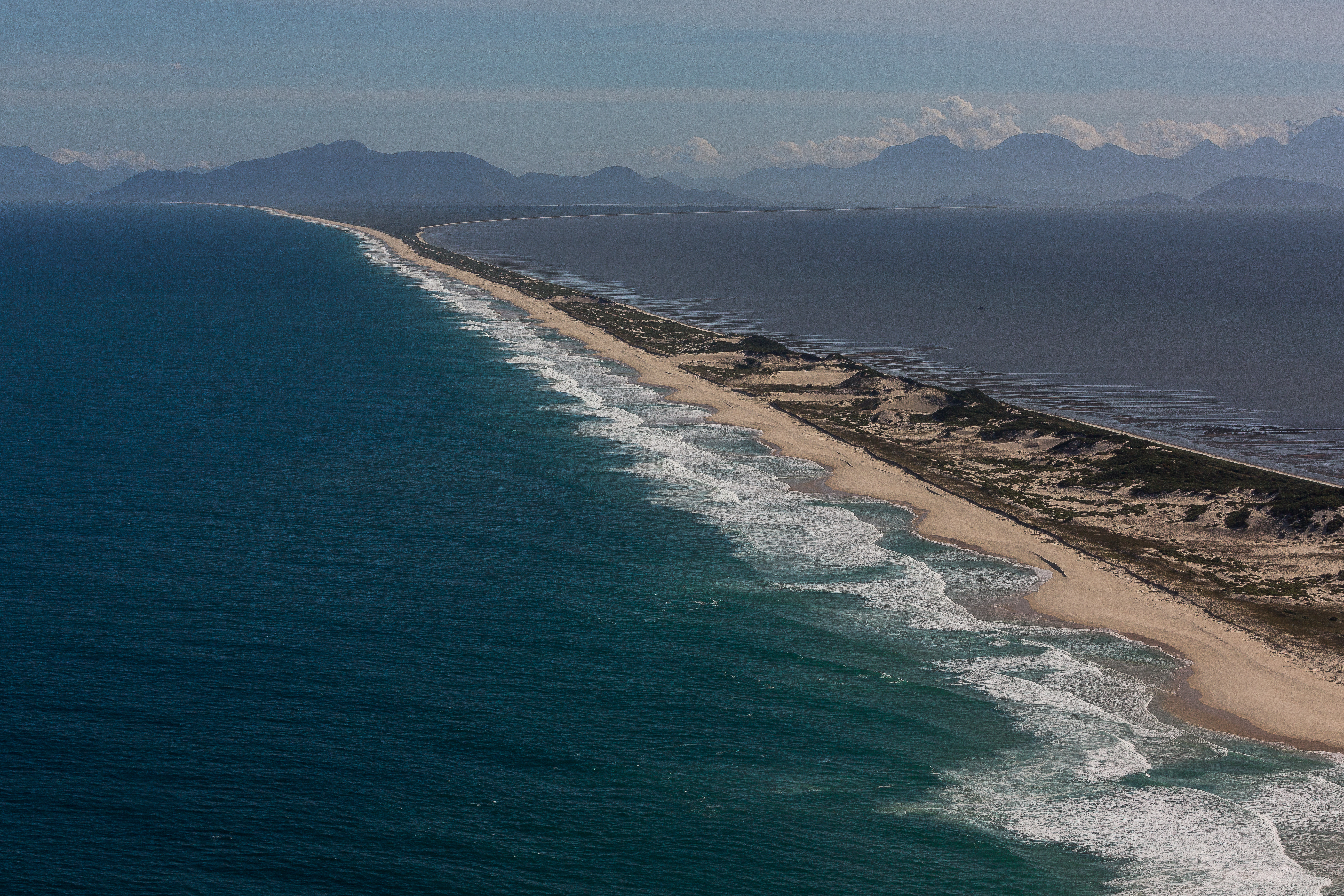
Restingas () are a distinct type of coastal tropical and subtropical moist broadleaf forest in eastern Brazil. They form on sandy, acidic, and nutrient-poor soils, and are characterized by medium-sized trees and shrubs adapted to the drier and nutrient-poor conditions. One of the most notable restingas is the Restinga da Marambaia (in Rio de Janeiro), which is owned and kept by the Brazilian Army. Ecoregions The World Wildlife Fund distinguishes two ''Restinga'' ecoregions. * Atlantic Coast restingas — found in several enclaves along Brazil's east coast from Rio Grande do Norte state in northeastern Brazil to Rio Grande do Sul state in southern Brazil, covering an area of that extends from the tropics to the subtropics. Its flora and fauna shares affinities with the humid Atlantic forest of eastern Brazil. * Northeastern Brazil restingas — found along the northern coast of Brazil, in Maranhão, Piauí, and Ceará Ceará (, ) is one of the 26 states of Brazil, located ... [...More Info...] [...Related Items...] OR: [Wikipedia] [Google] [Baidu] |
Atlantic Coast Restingas
The Atlantic Coast restingas is an ecoregion of the tropical and subtropical moist broadleaf forests biome, and the South American Atlantic Forest biome. It is located along Brazil's Atlantic coast, from the country's northeast to its southeast. Restingas are coastal forests which form on sandy, acidic, and nutrient-poor soils, and are characterized by medium-sized trees and shrubs adapted to the dry and nutrient-poor conditions found there. Setting The ecoregion covers an area of , and includes several well-defined enclaves that range along the Atlantic coast from Brazil's northeast to southeast, extending from the tropics to the subtropics. The northernmost enclave is in Rio Grande do Norte state in northeastern Brazil. Other enclaves are north and south of the city of Salvador and near the mouth of the Jequitinhonha River in Bahia state; north and south of the mouth of the Rio Paraíba do Sul in Rio de Janeiro state; and along the coast of southern Santa Catarina state a ... [...More Info...] [...Related Items...] OR: [Wikipedia] [Google] [Baidu] |
Restinga Da Marambaia
The Restinga da Marambaia is a restinga in the coast of the Brazilian state of Rio de Janeiro. It is 42 km long and separates Sepetiba Bay from the Atlantic Ocean, being a part of the municipalities of Rio de Janeiro, Itaguaí and Mangaratiba. It is owned and run by the Brazilian army. It is used as a leisure ground for military staff and their friends and families, as well as for scientific research in the untouched Atlantic Rainforest found within the restinga. It has been used as a setting for several telenovelas, including '' Kubanacan'' and ''Da Cor do Pecado ''Da Cor do Pecado'' (English title: ''Shades of Sin'') is a Brazilian telenovela produced and broadcast by TV Globo in the traditional 7pm timeslot between 26 January and 28 August 2004 with a total of 185 episodes, replacing ''Kubanacan'' and p ...''. References Landforms of Rio de Janeiro (state) Coasts of Brazil Spits (landform) {{RiodeJaneiro-geo-stub ... [...More Info...] [...Related Items...] OR: [Wikipedia] [Google] [Baidu] |
Northeastern Brazil Restingas
The Northeastern Brazil restingas are an ecoregion of northeastern Brazil. Restingas are coastal forests which form along coastal sand dunes in Brazil. The soils are typically sandy, acidic, and nutrient-poor, and are characterized by medium-sized trees and shrubs adapted to local conditions. Restingas have aspects of mangroves, caatingas, wetlands, and moist forests, often forming along wind-driven sand dunes. The Northeast Brazil restingas are the most northerly of the forest type in Brazil. Location and description The ecoregion extends 400 km along the northeast Atlantic coast of Brazil, and up to 100 km inland. This covers an area of along oasts of eastern Maranhão, Piauí, and western Ceará states. The ecoregion includes the Lençóis Maranhenses National Park, where patches of restinga are interspersed with some of the most extensive coastal dunes in the world. The dune systems reflect the forces of tides that vary 6 meters. Climate The climate of the ec ... [...More Info...] [...Related Items...] OR: [Wikipedia] [Google] [Baidu] |
Amazon Biome
The Amazon biome () contains the Amazon rainforest, an area of tropical rainforest, and other ecoregions that cover most of the Amazon basin and some adjacent areas to the north and east. The biome contains blackwater river, blackwater and whitewater river (river type), whitewater flooded forest, lowland and montane terra firma forest, bamboo and palm forest, savanna, sandy heath and alpine tundra. Some areas of the biome are threatened by deforestation for timber and to make way for pasture or soybean plantations. Location The Amazon biome has an area of . The biome roughly corresponds to the Amazon basin, but excludes areas of the Andes to the west and cerrado (savannah) to the south, and includes lands to the northeast extending to the Atlantic ocean with similar vegetation to the Amazon basin. J. J. Morrone (2006) defines the Amazonian subregion in this broader sense, divided into the Biogeography, biogeographical provinces of Guyana, Humid Guyana, Napo, Imeri, Roraima, Amapá ... [...More Info...] [...Related Items...] OR: [Wikipedia] [Google] [Baidu] |
Floresta De Restinga E Mangue - Itaguaré
Floresta may refer to: Geography * Floresta, Paraná, a city in the state of Paraná, Brazil * Floresta, Pernambuco, a city in the state of Pernambuco, Brazil * Floresta, Rio Grande do Sul, a neighbourhood in Porto Alegre, Brazil * Floresta, Boyacá, a municipality in Boyacá Department, Colombia * Floresta, Buenos Aires, a neighborhood in Buenos Aires, Argentina * Floresta, Sicily, a municipality in the province of Messina, Sicily * La Floresta, Uruguay, a small city in Canelones Department, Uruguay * La Floresta, Guayaquil, a neighborhood in Guayaquil, Ecuador Geology * Floresta Formation The Floresta Formation (, Df) is a geological formation of the Altiplano Cundiboyacense in the Eastern Ranges of the Colombian Andes. The sequence of siltstones, shales, coquinas and sandstone beds dates to the Devonian period; Late Emsian, Eif ..., a fossiliferous geological formation of the Altiplano Cundiboyacense, named after Floresta, Boyacá See also * La Floresta (disambi ... [...More Info...] [...Related Items...] OR: [Wikipedia] [Google] [Baidu] |
Forests Of Brazil
A forest is an ecosystem characterized by a dense community of trees. Hundreds of definitions of forest are used throughout the world, incorporating factors such as tree density, tree height, land use, legal standing, and ecological function. The United Nations' Food and Agriculture Organization (FAO) defines a forest as, "Land spanning more than 0.5 hectares with trees higher than 5 meters and a canopy cover of more than 10 percent, or trees able to reach these thresholds ''in situ''. It does not include land that is predominantly under agricultural or urban use." Using this definition, '' Global Forest Resources Assessment 2020'' found that forests covered , or approximately 31 percent of the world's land area in 2020. Forests are the largest terrestrial ecosystems of Earth by area, and are found around the globe. 45 percent of forest land is in the tropical latitudes. The next largest share of forests are found in subarctic climates, followed by temperate, and subtropic ... [...More Info...] [...Related Items...] OR: [Wikipedia] [Google] [Baidu] |
Tropical And Subtropical Moist Broadleaf Forests
Tropical and subtropical moist broadleaf forests (TSMF), also known as tropical moist forest, is a subtropical and tropical forest habitat type defined by the World Wide Fund for Nature (WWF). Description TSMF is generally found in large, discontinuous patches centered on the equatorial belt and between the Tropic of Cancer and Tropic of Capricorn. TSMF are characterized by low variability in annual temperature and high levels of rainfall of more than annually. Forest composition is dominated by evergreen and semi-deciduous tree species. These forests are home to more species than any other terrestrial ecosystem on Earth: Half of the world's species may live in these forests, where a square kilometer may be home to more than 1,000 tree species. These forests are found around the world, particularly in the Indo-Malayan Archipelago, the Amazon Basin, and the African Congo Basin. The perpetually warm, wet climate makes these environments more productive than any ot ... [...More Info...] [...Related Items...] OR: [Wikipedia] [Google] [Baidu] |
Ecoregions Of Brazil
The following is a list of ecoregions in Brazil as identified by the World Wide Fund for Nature (WWF). Terrestrial ecoregions by major habitat type Tropical and subtropical moist broadleaf forests *Alto Paraná Atlantic forests (Argentina, Brazil, Paraguay) *Araucaria moist forests (Argentina, Brazil) *Atlantic Coast restingas (Brazil) *Bahia coastal forests (Brazil) *Bahia interior forests (Brazil) *Caatinga Enclaves moist forests (Brazil) *Fernando de Noronha-Atol das Rocas moist forests (Brazil) *Guayanan Highlands moist forests (Brazil, Colombia, Guyana, Suriname, Venezuela) *Guianan moist forests (Brazil, French Guiana, Guyana, Suriname, Venezuela) *Guianan piedmont and lowland moist forests (Brazil, Venezuela) *Gurupá várzea (Brazil) *Iquitos várzea (Bolivia, Brazil, Peru) *Japurá–Solimões–Negro moist forests (Brazil, Colombia, Venezuela) *Juruá–Purus moist forests (Brazil) *Madeira–Tapajós moist forests (Bolivia, Brazil) *Marajó várzea (Brazil) *Maranhão Bab ... [...More Info...] [...Related Items...] OR: [Wikipedia] [Google] [Baidu] |
List Of Plants Of Atlantic Forest Vegetation Of Brazil
A list is a set of discrete items of information collected and set forth in some format for utility, entertainment, or other purposes. A list may be memorialized in any number of ways, including existing only in the mind of the list-maker, but lists are frequently written down on paper, or maintained electronically. Lists are "most frequently a tool", and "one does not ''read'' but only ''uses'' a list: one looks up the relevant information in it, but usually does not need to deal with it as a whole".Lucie Doležalová,The Potential and Limitations of Studying Lists, in Lucie Doležalová, ed., ''The Charm of a List: From the Sumerians to Computerised Data Processing'' (2009). Purpose It has been observed that, with a few exceptions, "the scholarship on lists remains fragmented". David Wallechinsky, a co-author of ''The Book of Lists'', described the attraction of lists as being "because we live in an era of overstimulation, especially in terms of information, and lists help us ... [...More Info...] [...Related Items...] OR: [Wikipedia] [Google] [Baidu] |
Ceará
Ceará (, ) is one of the 26 states of Brazil, located in the Northeast Region, Brazil, northeastern part of the country, on the Atlantic Ocean, Atlantic coast. It is the List of Brazilian states by population, eighth-largest Brazilian State by population and the List of Brazilian states by area, 17th by area. It is also one of the main tourist destinations in Brazil. The List of capitals in Brazil, state capital is the city of Fortaleza, the country's fourth most populous city. The state has 4.3% of the Brazilian population and produces 2.1% of the Brazilian GDP. It is divided into 184 municipalities. Literally, the name ''Ceará'' means "sings the Aratinga, jandaia". According to José de Alencar, one of the most important writers of Brazil and an authority in Tupi Guaraní, ''Ceará'' means turquoise or green waters. The state is best known for its extensive coastline, with of sand. There are also mountains and valleys producing tropical fruits. To the south, on the border o ... [...More Info...] [...Related Items...] OR: [Wikipedia] [Google] [Baidu] |
Piauí
Piauí ( ) is one of the states of Brazil, located in the country's Northeast Region, Brazil, Northeast Region. The state has 1.6% of the Brazilian population and produces 0.7% of the Brazilian GDP. Piauí has the shortest coastline of any coastal Brazilian state at 66 km (41 mi), and the capital, Teresina, is the only state capital in the northeast to be located inland. The reason for this is, unlike the rest of the area, Piauí was first colonised inland and slowly expanded towards the ocean, rather than the other way around. In the southeast of the state, the National Park of Serra da Capivara National Park, Serra da Capivara is a UNESCO World Heritage Site. The park has more than 400 archaeological sites and the largest concentration of rock art, rock paintings in the world, in a landscape dominated by canyons and caatinga. History The state has many notable archaeological sites, including Serra de Capivara National Park and Sete Cidades National Park, which are ... [...More Info...] [...Related Items...] OR: [Wikipedia] [Google] [Baidu] |


