|
Pesca
Pesca is a town and municipality in the Colombian Department of Boyacá, part of the Sugamuxi Province, a subregion of Boyacá. The town is located in the Eastern Ranges of the Colombian Andes at altitudes between and . Pesca is west from the department capital Tunja and borders Firavitoba in the north, Iza in the northeast, Tuta in the northwest, in the east Tota, Zetaquirá in the south, Rondón and Siachoque in the southwest and Toca in the west. Notes Pesca is east from the department capital Tunja Etymology In the Chibcha language of the Muisca, Pesca means "strong enclosure". History Before the arrival of the Spanish in the 1530s, Pesca was part of the Muisca Confederation, a confederation of different rulers; ''zaques'' based in Hunza, ''zipas'' ruling from Muyquytá and '' caciques'' in other territories. Pesca was reigned by the ''iraca'' of sacred City of the Sun Sugamuxi, now called Sogamoso. Modern Pesca was founded by Juan de Sanct Martín on ... [...More Info...] [...Related Items...] OR: [Wikipedia] [Google] [Baidu] |
Juan De Sanct Martín
Juan de Sanct Martín, also known as Juan de San Martín, was a Spanish conquistador. Little is known about De Sanct Martín, apart from a passage in ''El Carnero'' (1638) by Juan Rodríguez Freyle and '' Epítome de la conquista del Nuevo Reino de Granada'', a work of uncertain authorship.''Epítome'', p.82 He took part in the expedition from Santa Marta into the Eastern Ranges of the Colombian Andes led by Gonzalo Jiménez de Quesada and founded Cuítiva, Boyacá in 1550.List of conquistadors led by Gonzalo Jiménez de Quesada - Juan de Sanct Martín headed the left flank of the Spanish troops in ... [...More Info...] [...Related Items...] OR: [Wikipedia] [Google] [Baidu] |
Tota, Boyacá
Tota is a town and municipality in the department of Boyacá, Colombia, part of the Sugamuxi Province. Tota is located approximately 40 km from Sogamoso and the municipality borders in the north Cuítiva, Aquitania in the east, Zetaquirá and San Eduardo in the south and westward of Tota the municipality of Pesca is located.Official website Tota - accessed 02-05-2016 Nearby and named after the village is , the largest lake of Colombia. History Before the of the central highlands of Colombia ( |
Muisca Confederation
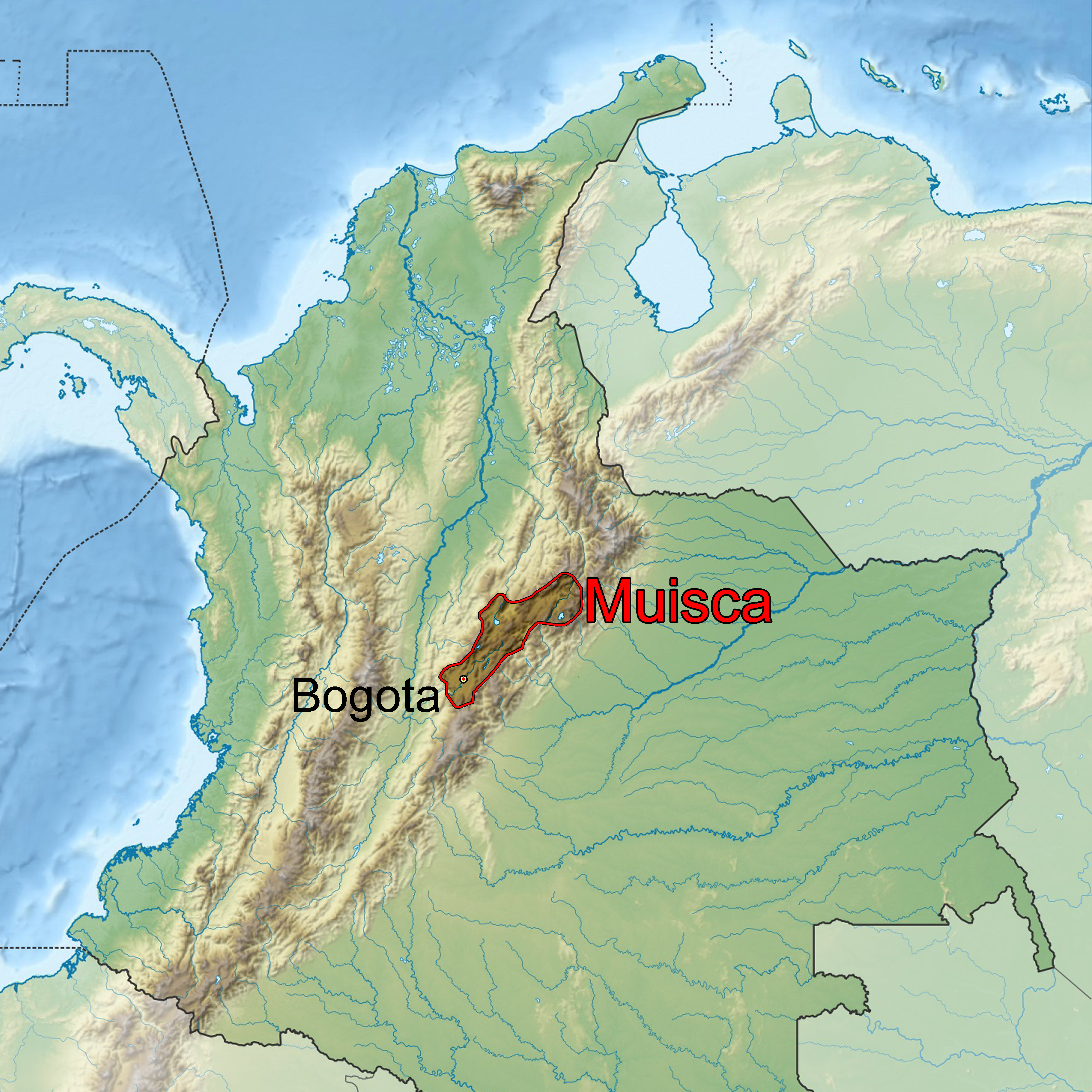
The Muisca Confederation was a loose confederation of different Muisca rulers (''zaques'', ''zipas'', ''iraca'', and ''tundama'') in the central Andean highlands of present-day Colombia before the Spanish conquest of northern South America. The area, presently called Altiplano Cundiboyacense, comprised the current departments of Boyacá, Cundinamarca and minor parts of Santander. According to some Muisca scholars the Muisca Confederation was one of the best-organized confederations of tribes on the South American continent. Modern anthropologists, such as Jorge Gamboa Mendoza, attribute the present-day knowledge about the confederation and its organization more to a reflection by Spanish chroniclers who predominantly wrote about it a century or more after the Muisca were conquered and proposed the idea of a loose collection of different people with slightly different languages and backgrounds.Gamboa Mendoza, 2016 Geography Climate Muisca Confederation In th ... [...More Info...] [...Related Items...] OR: [Wikipedia] [Google] [Baidu] |
Sugamuxi Province
The Sugamuxi Province () is a subregion of the Colombian Department of Boyacá. The subregion is formed by 13 municipalities. Etymology The name of the province comes from Sugamuxi, the last ''iraca'' of the Muisca and means in Chibcha: "Dwelling of the Sun".Etymology Sugamuxi - Excelsio.net Subdivision Sugamuxi Province comprises 13 municipalities:Provincias de Boyacá/ref> References Provinces of Boyacá Department |
Rondón, Boyacá
Rondón is a town and municipality in the Márquez Province, part of Boyacá Department, Colombia. The urban centre of Rondón is situated at an altitude of on the Altiplano Cundiboyacense in the Colombian Eastern Ranges of the Andes. It is away from the departmental capital Tunja. Rondón borders Viracachá and Siachoque in the north, Zetaquirá and Ramiriquí in the south, Pesca in the east and Ramiriquí and Ciénega in the west. Etymology Previously, Rondón was called San Rafael. In earlier times, the area of Rondón was known as a forested terrain called La Galera. It received the name Rondón honouring the independence hero of the Battle of Vargas Swamp Juan José Rondón. History The terrain of Rondón was completely forested until the mid 19th century, when the lands passed through various families of land owners. The newly founded settlement was populated by people coming from Ramiriquí, Ciénega, Viracachá and Pesca. The town received the status of mu ... [...More Info...] [...Related Items...] OR: [Wikipedia] [Google] [Baidu] |
Iraca
The ''iraca'', sometimes spelled ''iraka'',Ocampo López, 2013, Ch.12, p.77Ocampo López, 2013, Ch.14, p.85 was the ruler and high priest of Sugamuxi in the confederation of the Muisca who inhabited the Altiplano Cundiboyacense; the central highlands of the Colombian Andes. ''Iraca'' can also refer to the Iraka Valley over which they ruled. Important scholars who wrote about the ''iraca'' were Lucas Fernández de Piedrahita, Alexander von Humboldt and Ezequiel Uricoechea. Background In the centuries before the Spanish conquistadores entered central Colombia in the 1530s, the valleys of the Eastern Ranges were ruled by four main leaders and several independent '' caciques''. The northern territories were ruled by the ''zaque'' from Hunza, the present-day capital of Boyacá department and the southern area under the reign of the ''zipa'', based in Bacatá, currently known as the Colombian capital Bogotá. Other important rulers were the ''iraca'' and the ''cacique'' Tunda ... [...More Info...] [...Related Items...] OR: [Wikipedia] [Google] [Baidu] |
Firavitoba
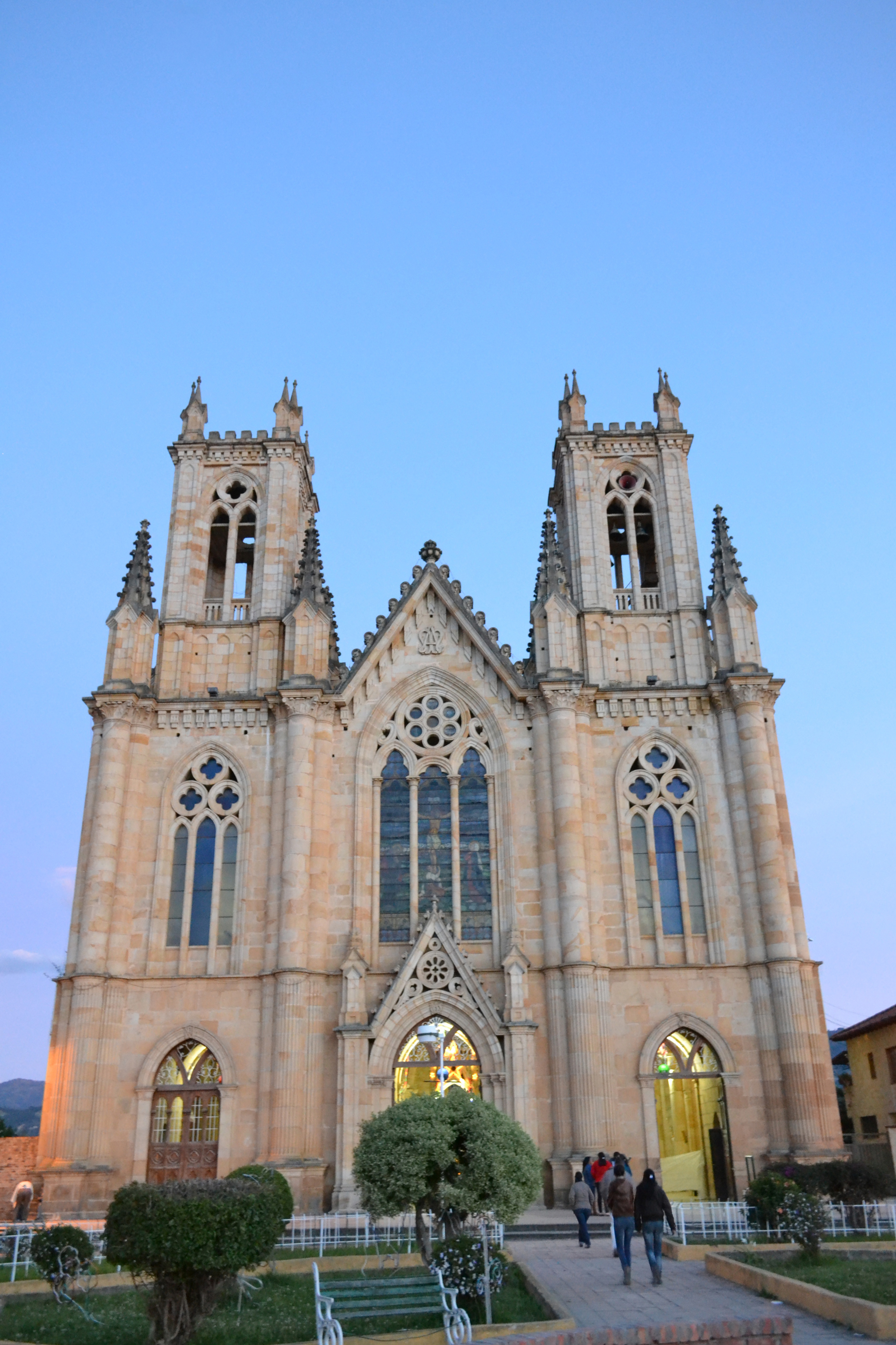
Firavitoba is a town and municipality in Sugamuxi Province, a subregion of the department of Boyacá in Colombia. Before Spanish colonization, Firavitoba was part of the Muisca Confederation of the Chibcha people in the highlands of the Eastern Cordillera of the Colombian Andes. Firavitoba belonged to the Iraca or Suamox state which, uniquely, did not observe a hereditary leadership system but elected its ruler alternately from Firavitoba and Tobasá, two of its many tribes. Firavitoba is distinguished by its neo-Gothic church, the third biggest in Colombia. Nuestra Señora de las Nieves (Our Lady of the Snows) was built between 1873 and 1976, entirely of stone sourced from nearby Sogamoso's Pedregal district. Etymology The name Firavitoba derives from the Muysccubun language of the Muisca people. One etymology gives the root words as ''fiba'' ("air"), and ''faoa'' ("clouds"). Geography Firavitoba is located on the Altiplano Cundiboyacense, at an altitude of metres a ... [...More Info...] [...Related Items...] OR: [Wikipedia] [Google] [Baidu] |
Siachoque
Siachoque is a town and municipality in the Central Boyacá Province, part of the Colombian department of Boyacá. Siachoque is situated on the Altiplano Cundiboyacense at a distance of from the department capital Tunja. It borders Toca in the north, Rondón and Viracachá in the south, in the east Toca, Pesca and Rondón and in the west Soracá and Chivatá. Etymology The name Siachoque comes from the Chibcha language of the Muisca people who inhabited the central highlands of present-day Colombia before the Spanish conquest. It is composed of the words ''Si''; "here", ''a''; "from, taste, smell", ''chó''; "good" and ''que''; "vigorous fortress", translating as "place of good smells and strong and vigorous cultures" or "Land of the vigorous taste".Etymology Siachoque - Excelsio.net ...
|
Muisca People
The Muisca (also called Chibcha) are an indigenous people and culture of the Altiplano Cundiboyacense, Colombia, that formed the Muisca Confederation before the Spanish conquest. The people spoke Muysccubun, a language of the Chibchan language family, also called ''Muysca'' and ''Mosca''. They were encountered by conquistadors dispatched by the Spanish Empire in 1537 at the time of the conquest. Subgroupings of the Muisca were mostly identified by their allegiances to three great rulers: the ''hoa'', centered in Hunza, ruling a territory roughly covering modern southern and northeastern Boyacá and southern Santander; the '' psihipqua'', centered in Muyquytá and encompassing most of modern Cundinamarca, the western Llanos; and the '' iraca'', religious ruler of Suamox and modern northeastern Boyacá and southwestern Santander. The territory of the Muisca spanned an area of around from the north of Boyacá to the Sumapaz Páramo and from the summits to the we ... [...More Info...] [...Related Items...] OR: [Wikipedia] [Google] [Baidu] |
Toca, Boyacá
Toca is a town and municipality in the Colombian Department of Boyacá, part of the subregion of the Central Boyacá Province. Toca is situated on the Altiplano Cundiboyacense northeast from the department capital Tunja. It borders Tuta in the north, Siachoque in the south, Pesca in the east and Tuta and Chivatá in the west. History Before the Spanish conquest of the central highlands of the Colombian Andes, the area was inhabited by the Muisca people, organized in a loose confederation of different rulers. Toca was reigned by the ''iraca'' of Sugamuxi, present-day Sogamoso. The troops of conquistador Gonzalo Jiménez de Quesada entered the Altiplano Cundiboyacense in 1537. The year of foundation of modern Toca is not entirely clear, but set at 1555 by Pedro Ruíz García. Etymology In the Chibcha language of the Muisca, Toca means "Domain of the river". [...More Info...] [...Related Items...] OR: [Wikipedia] [Google] [Baidu] |
Municipalities Of Colombia
The Municipalities of Colombia are decentralized subdivisions of the Republic of Colombia. Municipalities make up most of the departments of Colombia with 1,122 municipalities (''municipios''). Each one of them is led by a mayor (''alcalde'') elected by popular vote and represents the maximum executive government official at a municipality level under the mandate of the governor of their department which is a representative of all municipalities in the department; municipalities are grouped to form departments. The municipalities of Colombia are also grouped in an association called the ''Federación Colombiana de Municipios'' (Colombian Federation of Municipalities), which functions as a union under the private law and under the constitutional right to free association to defend their common interests. Categories Conforming to the law 1551/12 that modified the sixth article of the law 136/94 Article 7 http://www.alcaldiabogota.gov.co/sisjur/normas/Norma1.jsp?i=48267 the m ... [...More Info...] [...Related Items...] OR: [Wikipedia] [Google] [Baidu] |
Zetaquirá
Zetaquirá () is a town and municipality in the Colombian Lengupá Province, part of the department of Boyacá. Zetaquirá is located at from the department capital Tunja and borders Pesca in the north, Miraflores in the south, in the east Berbeo, San Eduardo and Aquitania and in the west Ramiriquí and Chinavita. The municipality stretches over an area of on the Altiplano Cundiboyacense at altitudes between and . Etymology Zetaquirá in Chibcha means "Land of the snake" or "City of the snake".Etymology Municipalities Boyacá - Excelsio.net History The central highlands of the Colombian in the time before the |


