|
Providence, Guyana
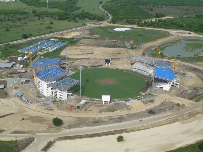
Providence is a community in the Demerara-Mahaica Region of Guyana, on the east bank of the Demerara River The Demerara River is a river in eastern Guyana that rises in the central rainforests of the country and flows to the north for 346 kilometres until it reaches the Atlantic Ocean. Georgetown, Guyana's largest seaport and capital, is situated on ..., located at , altitude 1 metre (3 feet). Providence is approximately south of the capital, Georgetown. Providence is the home of the international cricket venue Providence Stadium. It also held few matches of 2007 ICC Cricket World Cup. References External links * Populated places in Demerara-Mahaica {{Guyana-geo-stub ... [...More Info...] [...Related Items...] OR: [Wikipedia] [Google] [Baidu] [Amazon] |
Flag Of Guyana
The flag of Guyana, known as the Golden Arrowhead, has been the national flag of Guyana since May 1966, when the country became independent from the United Kingdom. It was designed by Whitney Smith, an American vexillologist (though originally without the black and white fimbriations, which were later additions suggested by the College of Arms in the United Kingdom). The proportions of the national flag are 3:5. The colours are symbolic: * red for zeal and dynamism, * gold (color), gold for mineral wealth, * green for agriculture and forests, * black for endurance, * white for rivers and water. Gallery The civil air ensign is a copy of the British Civil Air Ensign, with the Guyanese flag in the Flag terminology, canton. The naval ensign of Guyana is a version of the national flag, with proportions of 1:2. As part of the British Empire, Guyana's flag was a Blue Ensign with the colonial badge in the fly. An unofficial Red Ensign, red version was used at sea. The first flag ... [...More Info...] [...Related Items...] OR: [Wikipedia] [Google] [Baidu] [Amazon] |
Guyana
Guyana, officially the Co-operative Republic of Guyana, is a country on the northern coast of South America, part of the historic British West Indies. entry "Guyana" Georgetown, Guyana, Georgetown is the capital of Guyana and is also the country's largest city. Guyana is bordered by the Atlantic Ocean to the north, Brazil to the south and southwest, Venezuela to the west, and Suriname to the east. With a land area of , Guyana is the third-smallest sovereign state by area in mainland South America after Uruguay and Suriname, and is the List of South American countries by population, second-least populous sovereign state in South America after Suriname; it is also List of countries and dependencies by population density, one of the least densely populated countries on Earth. The official language of the country is English language, English, although a large part of the population is bilingual in English and the indigenous languages. It has a wide variety of natural habitats and ... [...More Info...] [...Related Items...] OR: [Wikipedia] [Google] [Baidu] [Amazon] |
Regions Of Guyana
Guyana is divided into 10 regions: Each Region is administered by a Regional Democratic Council (RDC) which is headed by a Chairman. The Regions are divided into neighbourhood councils, known as Neighbourhood Democratic Councils (NDCs). The current regional structure was established by the Local Democratic Organs Act in 1980. The hyphenated names indicate the name of the rivers that define their border. Historical divisions Previous regional names: Regions of Guyana (1971) * East Berbice-Corentyne * East Demerara-West Coast Berbice * Mazaruni Potaro * North West * Rupununi * West Demerara-Essequibo Coast Regions of British Guiana (1958) * East Berbice * Essequibo * Essequibo Islands * North west (hinterlands) * Mazaruni-Potaro (hinterlands) * Rupununi (hinterlands) Colonial counties (before 1958) * Essequibo * Demerara * Berbice See also * ISO 3166-2:GY * List of Caribbean First-level Subdivisions by Total Area This is a list of first-level country subd ... [...More Info...] [...Related Items...] OR: [Wikipedia] [Google] [Baidu] [Amazon] |
Demerara-Mahaica
Demerara-Mahaica (Region 4) is a region of Guyana, bordering the Atlantic Ocean to the north, the region of Mahaica-Berbice to the east, the region of Upper Demerara-Berbice to the south and the region of Essequibo Islands-West Demerara to the west. It contains the country's capital Georgetown. Notable villages in the region include Buxton, Enmore, Victoria and Paradise. Population The Government of Guyana has administered three official censuses since the 1980 administrative reforms, in 1980, 1991 and 2002. Even though this administrative region is the smallest, it has the largest population out of all Guyana's Administrative Regions. In 2012, the population of Demerara-Mahaica was recorded at 313,429 people. Official census records for the population of the Demerara-Mahaica region are as follows: *2012 : 401,376 *2002 : 310,320 *1991 : 296,924 *1980 : 317,475 Communities With name variants in parentheses. *Ann's Grove *Agricola Village *Alberttown (ward of Georgetown) ... [...More Info...] [...Related Items...] OR: [Wikipedia] [Google] [Baidu] [Amazon] |
Demerara River
The Demerara River is a river in eastern Guyana that rises in the central rainforests of the country and flows to the north for 346 kilometres until it reaches the Atlantic Ocean. Georgetown, Guyana's largest seaport and capital, is situated on the east bank of the river's mouth. The river divides Essequibo Islands-West Demerara (Region 3) on the west bank from Demerara-Mahaica (Region 4) to the east. The name "Demerara" comes from a variant of the Arawak word "Immenary" or "Dumaruni" which means "river of the letter wood" (wood of '' Brosimum guianense'' tree). Features Demerara's estuary is narrow and the flowrate is rapid. This scouring action maintains a 5-to-6-metre-deep direct channel to the ocean. The river's deep brown color is primarily the result of the massive quantities of silt carried from upriver by the powerful currents. So powerful are these currents, that the ocean retains the Demerara's brown color for a considerable distance out to sea. Tributaries of th ... [...More Info...] [...Related Items...] OR: [Wikipedia] [Google] [Baidu] [Amazon] |
Georgetown, Guyana
Georgetown is the capital (political), capital and largest city of Guyana. It is situated in Demerara-Mahaica, region 4, on the Atlantic Ocean coast, at the mouth of the Demerara River. It is nicknamed the "Garden City of the Caribbean." It is the retail, administrative, and financial services centre of the country, and the city accounts for a large portion of Guyana's GDP. The city recorded a population of 118,363 in the 2012 census. All executive departments of Guyana's government are located in the city, including Parliament Building, Guyana, Parliament Building, Guyana's Legislative Building and the Court of Appeals, Guyana's highest judicial court. The State House, Guyana, State House (the official residence of the head of state), as well as the offices and residence of the head of government, are both located in the city. The Secretariat of the Caribbean Community, Secretariat of the international organization known as the Caribbean Community (CARICOM), with 15 member-stat ... [...More Info...] [...Related Items...] OR: [Wikipedia] [Google] [Baidu] [Amazon] |
Providence Stadium
The Providence Stadium or Guyana National Stadium is a sports stadium in Guyana, replacing Bourda as the national stadium. The stadium was built specifically to host Super Eight matches in the 2007 Cricket World Cup held in March and April 2007. The stadium hosted six World Cup matches between March 28, 2007 and April 9, 2007, most notably the match between Sri Lanka and South Africa in which Sri Lankan fast bowler Lasith Malinga became the first bowler in international cricket history to take four wickets in four consecutive balls. Built primarily for cricket matches, the stadium can be converted into a multi-use facility. History Built for the 2007 ICC Cricket World Cup, the stadium hosted six One Day Internationals as part of that competition, all at the Super Eights stage. As of June 2016, it has hosted ten more ODI games since the 2007 World Cup including a historic three Day/Night matches during the 2016 Tri Series involving West Indies, Australia and South Africa. This ... [...More Info...] [...Related Items...] OR: [Wikipedia] [Google] [Baidu] [Amazon] |
2007 ICC Cricket World Cup
The 2007 ICC Cricket World Cup was the ninth Cricket World Cup, a One Day International (ODI) cricket tournament that took place in the West Indies from 13 March to 28 April 2007. There were a total of 51 matches played, three fewer than at the 2003 World Cup (despite a field larger by two teams). The 16 competing teams were initially divided into four groups, with the two best-performing teams from each group moving on to a Super 8 format. Every team played a total of 6 matches in the Super 8 round; they didn't play with teams of their own group. They played a total of 6 teams from another three groups (the top 2 teams of all three groups) From this, Australia, New Zealand, Sri Lanka, and South Africa won through to the semi-finals, with Australia defeating Sri Lanka in the final to win their third consecutive World Cup and their fourth overall. Australia's unbeaten record in the tournament increased their total to 29 consecutive World Cup matches without loss, a streak dating ... [...More Info...] [...Related Items...] OR: [Wikipedia] [Google] [Baidu] [Amazon] |

