|
Ponta Nhô Martinho
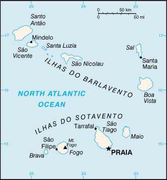
Ponta Nhô Martinho is a headland on the Island of Brava, Cape Verde. It is the southernmost point of Cape Verde. It is located nearly 4 km south of Cachaço, the nearest settlement. Formerly, the point was called ''Salt Point'' (Portuguese: ''Ponta do Sal''), for instance in the 1747 map by Jacques-Nicolas Bellin. There is a lighthouse on Ponta Nhô Martinho, which is the southernmost structure in Cape Verde. Its focal plane is above sea level. See also *List of lighthouses in Cape Verde *Geography of Cape Verde Cape Verde (formally, the Republic of Cabo Verde) is a group of arid Atlantic islands which are home to distinct communities of plants, birds, and reptiles. Location and description The Cape Verde Islands are located in the mid-Atlantic Ocean ... References {{Authority control , additional=Q30621903 Headlands of Cape Verde Geography of Brava, Cape Verde Porto Novo Municipality Ponta Nhô Martinho ... [...More Info...] [...Related Items...] OR: [Wikipedia] [Google] [Baidu] |
Headland
A headland, also known as a head, is a coastal landform, a point of land usually high and often with a sheer drop, that extends into a body of water. It is a type of promontory. A headland of considerable size often is called a cape.Whittow, John (1984). ''Dictionary of Physical Geography''. London: Penguin, 1984, pp. 80, 246. . Headlands are characterised by high, breaking waves, rocky shores, intense erosion, and steep sea cliff. Headlands and bays are often found on the same coastline. A bay is flanked by land on three sides, whereas a headland is flanked by water on three sides. Headlands and bays form on discordant coastlines, where bands of rock of alternating resistance run perpendicular to the coast. Bays form when weak (less resistant) rocks (such as sands and clays) are eroded, leaving bands of stronger (more resistant) rocks (such as chalk, limestone, and granite) forming a headland, or peninsula. Through the deposition of sediment within the bay and the erosio ... [...More Info...] [...Related Items...] OR: [Wikipedia] [Google] [Baidu] |
Brava, Cape Verde
Brava (Portuguese Language, Portuguese for "wild" or "brave") is an island in Cape Verde, and is part of the Sotavento Islands, Sotavento group, in the central Atlantic Ocean. At , it is the smallest inhabited island of the Cape Verde archipelago, but at the same time the greenest. First settled in the early 16th century, its population grew after Mount Fogo on neighbouring Fogo, Cape Verde, Fogo erupted in 1680. For more than a century, its main industry was whaling, but the island economy is now primarily agricultural. History Brava was discovered in 1462 by the Portuguese people, Portuguese explorer Diogo Afonso.Valor simbólico do centro histórico da Praia Lourenço Conceição Gomes, Universidade Portucalense, 2008, p. 97 There is no evidence of human presence on the Cape Verde islands before the arrival of the ... [...More Info...] [...Related Items...] OR: [Wikipedia] [Google] [Baidu] |
Atlantic Ocean
The Atlantic Ocean is the second largest of the world's five borders of the oceans, oceanic divisions, with an area of about . It covers approximately 17% of Earth#Surface, Earth's surface and about 24% of its water surface area. During the Age of Discovery, it was known for separating the New World of the Americas (North America and South America) from the Old World of Afro-Eurasia (Africa, Asia, and Europe). Through its separation of Afro-Eurasia from the Americas, the Atlantic Ocean has played a central role in the development of human society, globalization, and the histories of many nations. While the Norse colonization of North America, Norse were the first known humans to cross the Atlantic, it was the expedition of Christopher Columbus in 1492 that proved to be the most consequential. Columbus's expedition ushered in an Age of Discovery, age of exploration and colonization of the Americas by European powers, most notably Portuguese Empire, Portugal, Spanish Empire, Sp ... [...More Info...] [...Related Items...] OR: [Wikipedia] [Google] [Baidu] |
Cape Verde
Cape Verde or Cabo Verde, officially the Republic of Cabo Verde, is an island country and archipelagic state of West Africa in the central Atlantic Ocean, consisting of ten volcanic islands with a combined land area of about . These islands lie between west of Cap-Vert, the westernmost point of continental Africa. The List of islands of Cape Verde, Cape Verde islands form part of the Macaronesia ecoregion, along with the Azores, the Canary Islands, Madeira and the Savage Isles. The Cape Verde archipelago was uninhabited until the 15th century, when Portuguese Empire, Portuguese explorers colonized the islands, establishing one of the first Age of Discovery, European settlements in the tropics. Due to its strategic position, Cape Verde became a significant location in the Atlantic slave trade, transatlantic slave trade during the 16th and 17th centuries. The islands experienced economic growth during this period, driven by their role by the rapid emergence of merchants, priva ... [...More Info...] [...Related Items...] OR: [Wikipedia] [Google] [Baidu] |
Headland
A headland, also known as a head, is a coastal landform, a point of land usually high and often with a sheer drop, that extends into a body of water. It is a type of promontory. A headland of considerable size often is called a cape.Whittow, John (1984). ''Dictionary of Physical Geography''. London: Penguin, 1984, pp. 80, 246. . Headlands are characterised by high, breaking waves, rocky shores, intense erosion, and steep sea cliff. Headlands and bays are often found on the same coastline. A bay is flanked by land on three sides, whereas a headland is flanked by water on three sides. Headlands and bays form on discordant coastlines, where bands of rock of alternating resistance run perpendicular to the coast. Bays form when weak (less resistant) rocks (such as sands and clays) are eroded, leaving bands of stronger (more resistant) rocks (such as chalk, limestone, and granite) forming a headland, or peninsula. Through the deposition of sediment within the bay and the erosio ... [...More Info...] [...Related Items...] OR: [Wikipedia] [Google] [Baidu] |
Cachaço . In 2010 its population was 228. Its elevation is 592 meters. Cachaço is the second southernmost settlement in Cape Verde, after nearby Tantum. Some 4 km south is the southernmost point in Cape Verde, Ponta Nhô Martinho.
Cachaço is a village on the island of Brava, Cape Verde. It is situated in the mountains, 4 km south of the island capital Nova Sintra Nova Sintra is a cityCabo Verde, Statistical Yearbook 2015 ... References Villages and settlements in Brava, Cape V ...[...More Info...] [...Related Items...] OR: [Wikipedia] [Google] [Baidu] |
Jacques-Nicolas Bellin
Jacques Nicolas Bellin (; 1703 – 21 March 1772) was a French hydrographer, geographer, and member of the French intellectual group called the philosophes. Bellin was born in Paris. He was hydrographer of France's hydrographic office, member of the ''Académie de Marine'' and of the Royal Society of London. Over a 50-year career, he produced many maps of particular interest to the ''Ministère de la Marine''. His maps of Canada and of French territories in North America (New France, Acadia, Louisiana) are particularly valuable. He died at Versailles. First ''Ingenieur de la Marine'' In 1721, at age 18, he was appointed hydrographer (chief cartographer) to the French Navy. In August 1741, he became the first ''Ingénieur de la Marine of the Dépot des cartes et plans de la Marine'' (the French Hydrographical Office) and was named Official Hydrographer of the French King. Prodigious work, high standard of excellence During his reign the Depot published a prodigious number ... [...More Info...] [...Related Items...] OR: [Wikipedia] [Google] [Baidu] |
List Of Lighthouses In Cape Verde
The following article is a list of lighthouses in Cape Verde. Cape Verde has tens of lighthouses scattered across its nine major islands. The lighthouses are administered by the Direction of Marine and Ports (''Direcção Geral de Marinha e Portos'') or DGMP. Boa Vista, Cape Verde, Boa Vista Brava, Cape Verde, Brava Fogo, Cape Verde, Fogo Maio, Cape Verde, Maio Sal, Cape Verde, Sal Santiago, Cape Verde, Santiago Santo Antão, Cape Verde, Santo Antão São Nicolau, Cape Verde, São Nicolau São Vicente, Cape Verde, São Vicente See also * Lists of lighthouses and lightvessels References External links {{DEFAULTSORT:Lighthouses in Cape Verde Cape Verde transport-related lists, Lighthouses Lighthouses in Cape Verde, * Lists of buildings and structures in Cape Verde, Lighthouses Lists of lighthouses, Cape Verde ... [...More Info...] [...Related Items...] OR: [Wikipedia] [Google] [Baidu] |
Geography Of Cape Verde
Cape Verde (formally, the Republic of Cabo Verde) is a group of arid Atlantic islands which are home to distinct communities of plants, birds, and reptiles. Location and description The Cape Verde Islands are located in the mid-Atlantic Ocean some off the west coast of the continent of Africa. The landscape varies from dry plains to high active volcanoes with cliffs rising steeply from the ocean. The climate is arid. The total size is . The archipelago consists of ten islands and five islets, divided into the windward (Barlavento) and leeward (Sotavento) groups. The six islands in the Barlavento group, which sits in the trade winds, are Santo Antão, São Vicente, Santa Luzia, São Nicolau, Sal, and Boa Vista. The total land mass is .Valor simbólico do centro histórico da Praia Lourenço Conceição Gomes, Un ... [...More Info...] [...Related Items...] OR: [Wikipedia] [Google] [Baidu] |
Headlands Of Cape Verde
A headland, also known as a head, is a coastal landform, a point of land usually high and often with a sheer drop, that extends into a body of water. It is a type of promontory. A headland of considerable size often is called a cape.Whittow, John (1984). ''Dictionary of Physical Geography''. London: Penguin, 1984, pp. 80, 246. . Headlands are characterised by high, breaking waves, rocky shores, intense erosion, and steep sea cliff. Headlands and bays are often found on the same coastline. A bay is flanked by land on three sides, whereas a headland is flanked by water on three sides. Headlands and bays form on discordant coastlines, where bands of rock of alternating resistance run perpendicular to the coast. Bays form when weak (less resistant) rocks (such as sands and clays) are eroded, leaving bands of stronger (more resistant) rocks (such as chalk, limestone, and granite) forming a headland, or peninsula. Through the deposition of sediment within the bay and the erosion of th ... [...More Info...] [...Related Items...] OR: [Wikipedia] [Google] [Baidu] |
Geography Of Brava, Cape Verde
Geography (from Ancient Greek ; combining 'Earth' and 'write', literally 'Earth writing') is the study of the lands, features, inhabitants, and phenomena of Earth. Geography is an all-encompassing discipline that seeks an understanding of Earth and its human and natural complexities—not merely where objects are, but also how they have changed and come to be. While geography is specific to Earth, many concepts can be applied more broadly to other celestial bodies in the field of planetary science. Geography has been called "a bridge between natural science and social science disciplines." Origins of many of the concepts in geography can be traced to Greek Eratosthenes of Cyrene, who may have coined the term "geographia" (). The first recorded use of the word γεωγραφία was as the title of a book by Greek scholar Claudius Ptolemy (100 – 170 AD). This work created the so-called "Ptolemaic tradition" of geography, which included "Ptolemaic cartographic theory." ... [...More Info...] [...Related Items...] OR: [Wikipedia] [Google] [Baidu] |


