|
Pont-Sondé
Pont-Sondé (, ) is a town in the communal section of Bocozelle in the Saint-Marc commune, in the Artibonite department of Haiti. Location Located within the Saint-Marc Arrondissement, Pont-Sondé is located at an important crossroads on the road linking the capital Port-au-Prince to the second largest city of Cap-Haïtien on the northern coast. History When the Haitian national highway was constructed in 1880, a bridge spanning across the Artibonite River was built. The settlement of Pont-Sondé then developed around this bridge. Pont-Sonde had about ten thousand inhabitants before the 2010 Haiti earthquake. Since then, the village has hosted a large influx of refugees. In September 2024, during the Gang war in Haiti Since 2020, Haiti's capital Port-au-Prince has been the site of an ongoing gang war. The government of Haiti and Haitian security forces have struggled to maintain their control of Port-au-Prince amid this conflict, with gangs reportedly control ..., pers ... [...More Info...] [...Related Items...] OR: [Wikipedia] [Google] [Baidu] |
2024 Pont-Sondé Attack
On 3 October 2024, the town of Pont-Sondé, Haiti, was the site of a massacre perpetrated by the Gran Grif gang, leaving at least 115 people dead and at least 50 injured. Thousands more fled the town after the attack, which is part of the ongoing gang war in Haiti. Background The Gran Grif gang operates in the department of Artibonite and is considered one of Haiti's cruelest gangs, with nine mass kidnappings attributed to the group between October 2023 and January 2024. The gang was formed after former legislator Prophane Victor began arming young men nearly a decade ago to secure his election and control the area. Both Victor and the gang's current leader Luckson Elan, have also been sanctioned by the United States in September 2024 and by the United Nations Security Council. Rumors of an impending attack on the town had been circulating since August 2024, after the gang accused residents of collaborating with a self-defense group called "The Coalition" and hindering the oper ... [...More Info...] [...Related Items...] OR: [Wikipedia] [Google] [Baidu] |
List Of Communes Of Haiti
The commune () is the third-level divisions of Haiti. The 10 departments have 42 arrondissements, which are divided into 147 communes and then into 571 communal sections. Communes are roughly equivalent to civil townships and incorporated municipalities. Administration Each commune has a municipal council (''conseil municipal'') compound of three members elected by the inhabitants of the commune for a 4-year term. The municipal council is led by a president often called ''mayor''.Each commune has a municipal assembly (''assemblée municipale'') who assists the council in its work. The members of the assembly are also elected for 4 years. Each commune is ruled by a municipality. List Artibonite * Dessalines Arrondissement ** Dessalines ** Desdunes ** Grande-Saline ** Petite Rivière de l'Artibonite * Gonaïves Arrondissement ** Gonaïves ** Ennery ** L'Estère * Gros Morne Arrondissement ** Gros-Morne ** Anse-Rouge ** Terre-Neuve * Marmelade Arrondissement ** Marmelad ... [...More Info...] [...Related Items...] OR: [Wikipedia] [Google] [Baidu] |
Gang War In Haiti
Since 2020, Haiti's capital Port-au-Prince has been the site of an ongoing gang war. The government of Haiti and Haitian security forces have struggled to maintain their control of Port-au-Prince amid this conflict, with gangs reportedly controlling up to 90% of the city by 2023. In response to the escalating gang fighting, an armed vigilante movement, known as ''bwa kale'', also emerged, with the purpose of fighting the gangs. On 2 October 2023, United Nations Security Council Resolution 2699 was approved, authorizing a Kenya-led " multinational security support mission" to Haiti. Until 2024, the war was between two major groups and their allies: the Revolutionary Forces of the G9 Family and Allies (FRG9 or G9) and the G-Pep. However, in February 2024 the two rival gangs formed a coalition opposing the government and the UN mission. In March 2024, gang violence spread throughout Port-au-Prince with the goal of obtaining the resignation of unelected acting prime minister Ariel ... [...More Info...] [...Related Items...] OR: [Wikipedia] [Google] [Baidu] |
2010 Haiti Earthquake
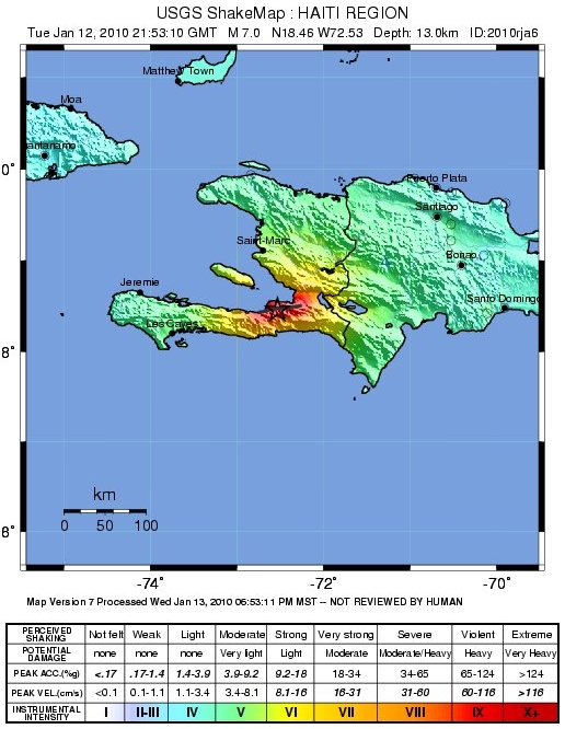
The 2010 Haiti earthquake was a catastrophic Moment magnitude scale, magnitude 7.0 Mw earthquake that struck Haiti at 16:53 local time (21:53 UTC) on Tuesday, 12 January 2010. The epicenter was near the town of Léogâne, Ouest (department), Ouest department, approximately west of Port-au-Prince, Haiti's capital. By 24 January, at least 52 aftershocks measuring 4.5 or greater had been recorded. An estimated three million people were affected by the quake. Death toll estimates range from 100,000 to about 160,000 to Haitian government figures from 220,000 to 316,000, although these latter figures are a matter of some dispute. The earthquake is the deadliest natural disaster of the 21st century for a single country. The government of Haiti estimated that 250,000 residential area, residences and 30,000 commercial buildings had collapsed or were severely damaged. Haiti's history of External debt of Haiti, national debt, prejudicial trade policies by other countries, and for ... [...More Info...] [...Related Items...] OR: [Wikipedia] [Google] [Baidu] |
Artibonite River
The Artibonite River ( French: ''Fleuve Artibonite''; Spanish: '' Río Artibonito''; Haitian Creole: ''Latibonit'') is the longest river in Haiti, and the longest on the island of Hispaniola. It is also the second-longest river in the Caribbean, behind the Cauto River in Cuba. Forming part of the international border between Haiti and the Dominican Republic, the river's sources are in the Cordillera Central in the Dominican Republic (68 km); however, most of its length lies in Haiti (253 km). Etymology The name is derived from the Taíno name of the river, ''Hatibonico''. Course The source of the Artibonite is to the northeast of Río Limpio, in the Cordillera Central, Dominican Republic. The mouth of the Artibonite is in Haiti, south of La Grand Saline. It flows into the Gulf of Gonâve. The river is the border between the Dominican Republic and Haiti for several kilometres, from the town of Pedro Santana to the point where it is joined by the River Macasía, and th ... [...More Info...] [...Related Items...] OR: [Wikipedia] [Google] [Baidu] |
Transport In Haiti
All of the major transportation systems in Haiti are located near or run through the capital, Port-au-Prince. Roads Haiti's network of roads consists of National Roads, Department Roads, and county roads. The hub of the road network is located at the old airport (at the intersection of Boulevard Jean-Jacques Dessalines and Autoroute de Delmas). From this intersection, Route Nationale #1 and Route Nationale #2 commence. * Route Nationale #1 (RN1) heads north, passing through Saint-Marc and Gonaïves to its terminus at Rue 22 in Cap-Haïtien. * Route Nationale #2 (RN2) is commonly known as “Boulevard Jean-Jacques Dessalines” within Port-au-Prince and as “Route du Sud” outside the capital region. After heading south through downtown Port-au-Prince, it travels west through the capital's western boroughs and then through Petit-Goâve and Aquin to its terminus at Avenue des Quatre Chemins in Les Cayes. (However, its “extension” continues southwest almost to the sea so ... [...More Info...] [...Related Items...] OR: [Wikipedia] [Google] [Baidu] |
Cap-Haïtien
Cap-Haïtien (; ; "Haitian Cape") is a List of communes of Haiti, commune of about 400,000 people on the north coast of Haiti and capital of the Departments of Haiti, department of Nord (Haitian department), Nord. Previously named ''Cap‑Français'' (; initially ''Cap-François'' ) and ''Cap‑Henri'' () during the rule of Henri Christophe, Henri I, it was historically nicknamed the ''Paris of the Antilles'', because of its wealth and sophistication, expressed through its architecture and artistic life. It was an important city during the colonial period, serving as the capital of the French Colony of Saint-Domingue from the city's formal foundation in 1711 until 1770 when the capital was moved to Port-au-Prince. After the Haitian Revolution, it became the capital of the Kingdom of Haiti under King Henri I until 1820. Cap-Haïtien's long history of independent thought was formed in part by its relative distance from Port-au-Prince, the barrier of mountains between it and the so ... [...More Info...] [...Related Items...] OR: [Wikipedia] [Google] [Baidu] |
Port-au-Prince
Port-au-Prince ( ; ; , ) is the Capital city, capital and List of cities in Haiti, most populous city of Haiti. The city's population was estimated at 1,200,000 in 2022 with the metropolitan area estimated at a population of 2,618,894. The metropolitan area is defined by the IHSI as including the Communes of Haiti, communes of Port-au-Prince, Delmas, Ouest, Delmas, Cité Soleil, Tabarre, Carrefour, Ouest, Carrefour, and Pétion-Ville. The city of Port-au-Prince is on the Gulf of Gonâve: the bay on which the city lies, which acts as a natural harbor, has sustained economic activity since the civilizations of the Taíno. It was first incorporated under Saint-Domingue, French colonial rule in 1749. The city's layout is similar to that of an amphitheater; commercial districts are near the water, while residential neighborhoods are located on the hills above. Its population is difficult to ascertain due to the rapid growth of slums in the hillsides above the city; however, recent ... [...More Info...] [...Related Items...] OR: [Wikipedia] [Google] [Baidu] |
Flag Of Haiti
The flag of Haiti ( French: ''drapeau d'Haïti''; Haitian Creole: ''drapo Ayiti'') is a bicolour featuring two horizontal bands coloured blue and red, emblazoned by a white rectangular panel bearing the coat of arms of Haiti. The coat of arms depicts a trophy of weapons atop a green hill and a royal palm symbolizing independence. The palm is topped by the Cap of Liberty. The motto ('Unity makes strength') appears on a white ribbon below the arrangement. Present design National flag The present design was first used by the Republic of Haiti under President Alexandre Pétion in 1806. It was most recently readopted on 25 February 2012 under Title I, Chapter I, Article 3 of the current Constitution of Haiti:L'emblême de la Nation Haïtienne est le Drapeau qui répond à la description suivante: The English translation adopted by the Embassy of Haiti in Washington, D.C., reads:The emblem of the Haitian Nation shall be a flag with the following description: Contrary to the co ... [...More Info...] [...Related Items...] OR: [Wikipedia] [Google] [Baidu] |
Haiti
Haiti, officially the Republic of Haiti, is a country on the island of Hispaniola in the Caribbean Sea, east of Cuba and Jamaica, and south of the Bahamas. It occupies the western three-eighths of the island, which it shares with the Dominican Republic. Haiti is the third largest country in the Caribbean, and with an estimated population of 11.4 million, is the most populous Caribbean country. The capital and largest city is Port-au-Prince. Haiti was originally inhabited by the Taíno people. In 1492, Christopher Columbus established the first European settlement in the Americas, La Navidad, on its northeastern coast. The island was part of the Spanish Empire until 1697, when the western portion was Peace of Ryswick, ceded to France and became Saint-Domingue, dominated by sugarcane sugar plantations in the Caribbean, plantations worked by enslaved Africans. The 1791–1804 Haitian Revolution made Haiti the first sovereign state in the Caribbean, the second republic in the Americ ... [...More Info...] [...Related Items...] OR: [Wikipedia] [Google] [Baidu] |
Communal Section
The communal section (, formerly section rurale) is the smallest administrative division in Haiti. The 144 List of communes of Haiti, communes are further divided into 571 communal sections. Operation It is headed by an executive body, the CASEC (Board of Communal Section) and a deliberative body, ASEC (Assembly of the Communal Section). These two institutions are aided by CDSC (the Development Council of the Communal Section). Within each, there are cities or neighborhoods, communities, ''habitations'', and '' lakou '' with sometimes difficult to grasp distinctions. List of communal sections of Haiti Artibonite (department), Artibonite Department Dessalines Arrondissement =Desdunes= * Desdunes =Dessalines= * Villard, Haiti, Villard * Fosse Naboth ou Duvallon * Ogé * Poste Pierrot * Fiéfé ou Petit Cahos * ll Croix ou Grand Cahos =Grande-Saline, Haiti, Grande-Saline= * Poteneau =Petite Rivière de l'Artibonite= * Bas Coursin I * Bas Coursin II * Labady * Savane à Roche ... [...More Info...] [...Related Items...] OR: [Wikipedia] [Google] [Baidu] |


