|
Platåberget
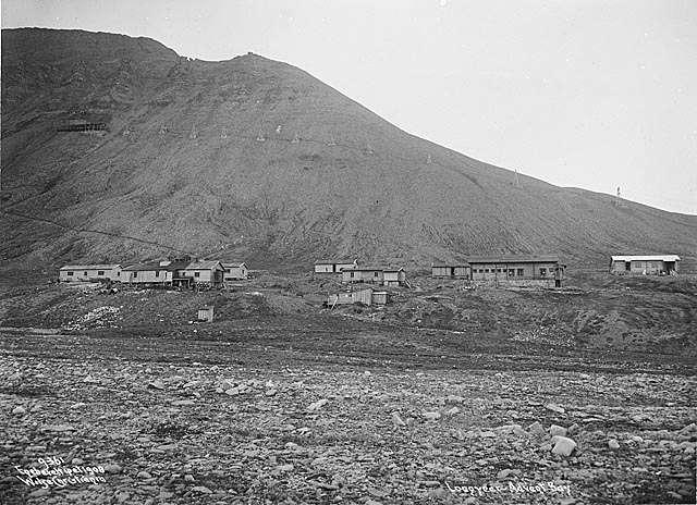
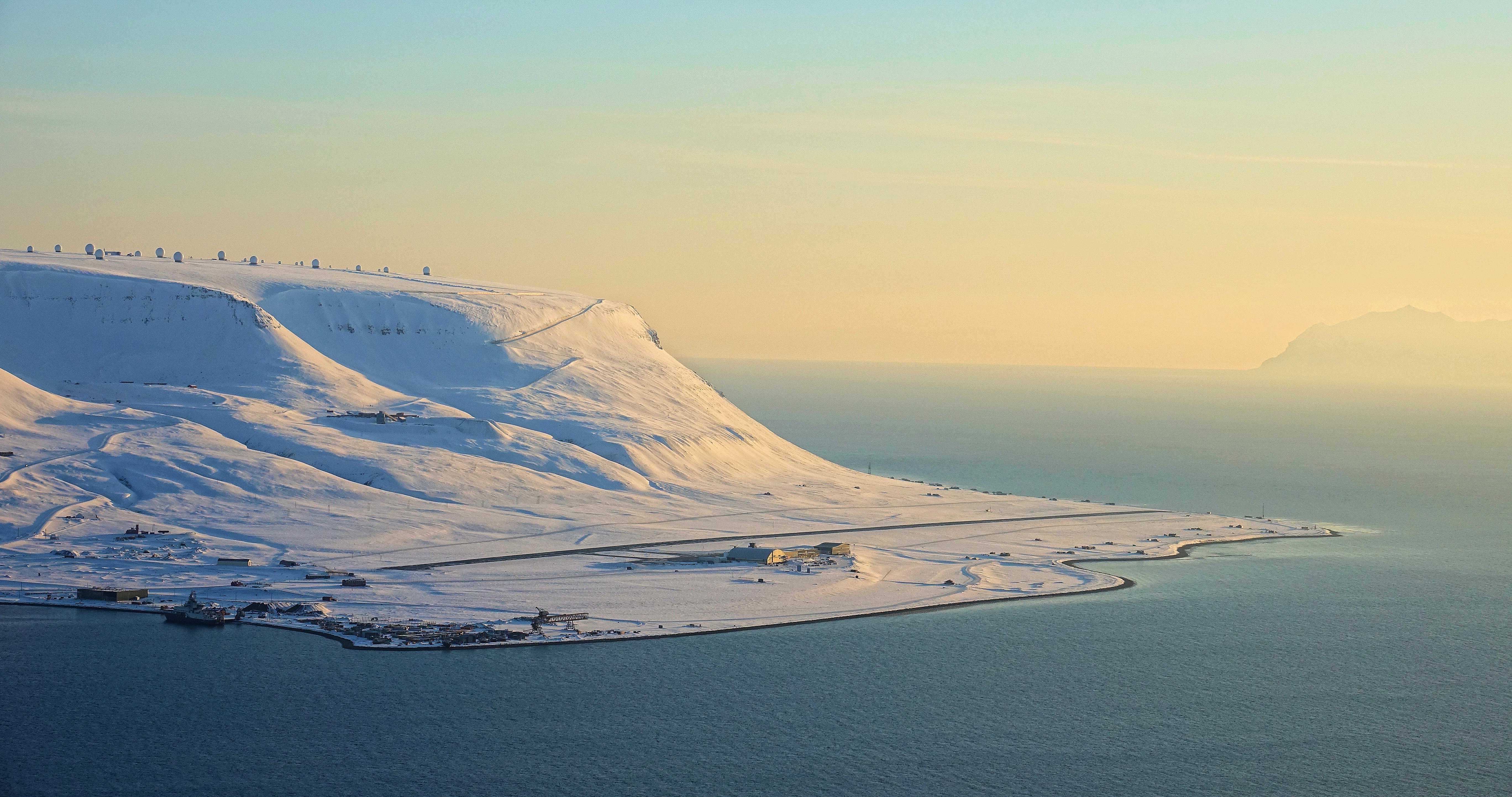
Platåberget is a mountain in Nordenskiöld Land on the island of Spitsbergen in Svalbard, Norway. It is tall and has a distinct plateau shape, for which it is named. It is bordered to the west by the Bjørndalen valley and the Fuglefjella bird cliffs, to the east by the Blomsterdalen mountain and to the north by Hotellneset and Adventfjorden. The mountain is a few kilometers from Longyearbyen and is next to Svalbard Airport, Longyear. It is the site of Svalbard Satellite Station and Svalbard Global Seed Vault. On 30 April 1995, a 22-year-old Norwegian college student, Nina Olaussen, was killed by a polar bear The polar bear (''Ursus maritimus'') is a large bear native to the Arctic and nearby areas. It is closely related to the brown bear, and the two species can Hybrid (biology), interbreed. The polar bear is the largest extant species of bear ... on Platåberget, only a few kilometers from Longyearbyen. [...More Info...] [...Related Items...] OR: [Wikipedia] [Google] [Baidu] |
Svalbard Satellite Station
Svalbard Satellite Station () or SvalSat is a satellite ground station located on Platåberget near Longyearbyen in Svalbard, Norway. Opened in 1997, it is operated by Kongsberg Satellite Services (KSAT), a joint venture between Kongsberg Defence & Aerospace and the Norwegian Space Centre (NSC). SvalSat and KSAT's Troll Satellite Station (TrollSat) in Antarctica are the only ground stations that can see a low altitude polar orbiting satellite (e.g., in Sun-synchronous orbit) on every revolution as the Earth rotates. As of 2021, the facility consists of 100 multi-mission and customer-dedicated antennas which operate in the C band (IEEE), C, L band, L, S band, S, X band, X and K_band_(IEEE), K bands. The station provides ground services to more satellites than any other facility in the world. Customers with their own installations include the European Organisation for the Exploitation of Meteorological Satellites (EUMETSAT), the National Aeronautics and Space Administration (NASA ... [...More Info...] [...Related Items...] OR: [Wikipedia] [Google] [Baidu] |
Longyearbyen
Longyearbyen (, , "Longyear Town") is the world's northernmost settlements, northernmost settlement with a population greater than 1,000, and the capital and the largest inhabited area of Svalbard. It stretches along the foot of the left bank (geography), bank of the Longyear Valley and on the shore of Adventfjorden, the short estuary leading into Isfjorden (Svalbard), Isfjorden on the west coast of Spitsbergen, the island's broadest inlet. As of 2002, Longyearbyen Community Council became an official municipalities of Norway, Norwegian municipality. It is the seat of the Governor of Svalbard. As of 2024, the town's mayor is Leif Terje Aunevik. Known as Longyear City until 1926, the town was established by and named after American John Munro Longyear, whose Arctic Coal Company started coal-mining there in 1906. Store Norske Spitsbergen Kulkompani (SNSK) took over the mining operations in 1916, and still conducts mining. The German ''Kriegsmarine'' almost completely Operation Zit ... [...More Info...] [...Related Items...] OR: [Wikipedia] [Google] [Baidu] |
Svalbard Airport, Longyear
Svalbard Airport (; ) is the main airport serving Svalbard in Norway. It is northwest of Longyearbyen on the west coast, and is the northernmost airport in the world with scheduled public flights. The first airport near Longyearbyen was constructed during World War II. In 1959, it was first used for occasional flights, but could only be used a few months a year. Construction of the new airport at Hotellneset started in 1973, and the airport was opened on 2 September 1975. It is owned and operated by state-owned Avinor. In 2014, the airport handled 154,261 passengers. Scandinavian Airlines operates daily flights to Tromsø and Oslo in mainland Norway. Lufttransport provides services to the other airport on Svalbard: Ny-Ålesund, using Dornier 228 turboprop aircraft. There are also regular charter flights. History Adventdalen The first airstrip on Svalbard was constructed in Adventdalen, near Longyearbyen, by the Luftwaffe during World War II. It was not used immediately after ... [...More Info...] [...Related Items...] OR: [Wikipedia] [Google] [Baidu] |
Hotellneset
Hotellneset ("Hotel Point") is a peninsula north-west of Longyearbyen in Svalbard, Norway Norway, officially the Kingdom of Norway, is a Nordic countries, Nordic country located on the Scandinavian Peninsula in Northern Europe. The remote Arctic island of Jan Mayen and the archipelago of Svalbard also form part of the Kingdom of ..., sticking out into Adventfjorden. It is the location of Svalbard Airport, Longyear and the port for shipping of coal from Longyearbyen. Above Hotellneset is Platåberget, which is the location for Svalbard Satellite Station. References Longyearbyen Peninsulas of Spitsbergen {{Spitsbergen-geo-stub ... [...More Info...] [...Related Items...] OR: [Wikipedia] [Google] [Baidu] |
Plateau
In geology and physical geography, a plateau (; ; : plateaus or plateaux), also called a high plain or a tableland, is an area of a highland consisting of flat terrain that is raised sharply above the surrounding area on at least one side. Often one or more sides have deep hills or escarpments. Plateaus can be formed by a number of processes, including upwelling of volcanic magma, extrusion of lava, and erosion by water and glaciers. Plateaus are classified according to their surrounding environment as intermontane, piedmont, or continental. A few plateaus may have a small flat top while others have wider ones. Formation Plateaus can be formed by a number of processes, including upwelling of volcanic magma, extrusion of lava, plate tectonics movements, and erosion by water and glaciers. Volcanic Volcanic plateaus are produced by volcanic activity. They may be formed by upwelling of volcanic magma or extrusion of lava. The underlining mechanism in forming p ... [...More Info...] [...Related Items...] OR: [Wikipedia] [Google] [Baidu] |
Fuglefjella Important Bird Area
The Fuglefjella Important Bird Area is a 500 ha tract of sea-cliffs in Spitsbergen, the largest island of Norway’s arctic Svalbard archipelago. The cliffs rise from sea level to an elevation of 470 m on the southern side of the inlet of Isfjorden, some 10 km west of the territory's principal human settlement of Longyearbyen. It was identified as an Important Bird Area (IBA) by BirdLife International because it supports about 20,000 breeding pairs of several species of seabirds such as little auks, fulmars, and the Svalbard rock ptarmigan The rock ptarmigan (''Lagopus muta'') is a medium-sized game bird in the grouse family. It is known simply as the ptarmigan in Europe. It is the official bird for the Canadian territory of Nunavut, where it is known as the ''aqiggiq'' (ᐊᕿ� .... References Landforms of Spitsbergen Important Bird Areas of Svalbard Cliffs of Norway {{Spitsbergen-geo-stub ... [...More Info...] [...Related Items...] OR: [Wikipedia] [Google] [Baidu] |
Norway
Norway, officially the Kingdom of Norway, is a Nordic countries, Nordic country located on the Scandinavian Peninsula in Northern Europe. The remote Arctic island of Jan Mayen and the archipelago of Svalbard also form part of the Kingdom of Norway. Bouvet Island, located in the Subantarctic, is a Dependencies of Norway, dependency, and not a part of the Kingdom; Norway also Territorial claims in Antarctica, claims the Antarctic territories of Peter I Island and Queen Maud Land. Norway has a population of 5.6 million. Its capital and largest city is Oslo. The country has a total area of . The country shares a long eastern border with Sweden, and is bordered by Finland and Russia to the northeast. Norway has an extensive coastline facing the Skagerrak strait, the North Atlantic Ocean, and the Barents Sea. The unified kingdom of Norway was established in 872 as a merger of Petty kingdoms of Norway, petty kingdoms and has existed continuously for years. From 1537 to 1814, Norway ... [...More Info...] [...Related Items...] OR: [Wikipedia] [Google] [Baidu] |
Adventfjorden
Adventfjorden (Advent Bay) is a 7 km long and 4 km wide bay running south-eastwards from the southern side of Isfjorden, on the west coast of Spitsbergen in Svalbard. The name represents a corruption of ''Adventure Bay'' - probably named after the Hull-built whaleship ''Adventure'', which operated in Isfjorden in 1656. The fjord was originally known as ''Klass Billen Bay''. At the head of Adventfjorden is Adventdalen (Advent Valley). The former mining-camp of Longyearbyen Longyearbyen (, , "Longyear Town") is the world's northernmost settlements, northernmost settlement with a population greater than 1,000, and the capital and the largest inhabited area of Svalbard. It stretches along the foot of the left bank ( ... (now Svalbard's main town) lies on the fjord's southwestern shore, while another former mining-camp, Hiorthhamn, is located on its northeastern shore. Gallery File:Adventfjord spitzbergen.jpg, Across Adventfjorden towards Adventtoppen and Hiorthfj ... [...More Info...] [...Related Items...] OR: [Wikipedia] [Google] [Baidu] |
Norwegian Polar Institute
The Norwegian Polar Institute (NPI; ) is Norway's central governmental institution for scientific research, mapping and environmental monitoring in the Arctic and the Antarctic. The NPI is a directorate under Norway's Ministry of Climate and Environment (Norway), Ministry of Climate and Environment. The institute advises Norwegian authorities on matters concerning polar environmental management and is the official environmental management body for Norwegian activities in Antarctica. Activities The institute's activities are focused on environmental research and management in the polar regions. The NPI's researchers investigate biodiversity, climate and environmental toxins in the Arctic and Antarctic, and in this context the institute equips and organizes large-scale expeditions to both polar regions. The institute contributes to national and international climate work, and is an active contact point for the international scientific community. The institute collects and analyses ... [...More Info...] [...Related Items...] OR: [Wikipedia] [Google] [Baidu] |
Svalbard
Svalbard ( , ), previously known as Spitsbergen or Spitzbergen, is a Norway, Norwegian archipelago that lies at the convergence of the Arctic Ocean with the Atlantic Ocean. North of continental Europe, mainland Europe, it lies about midway between the northern coast of Norway and the North Pole. The islands of the group range from 74th parallel north, 74° to 81st parallel north, 81° north latitude, and from 10th meridian east, 10° to 35th meridian east, 35° east longitude. The largest island is Spitsbergen (37,673 km2), followed in size by Nordaustlandet (14,443 km2), (5,073 km2), and Barentsøya (1,288 km2). Bear Island (Norway), Bjørnøya or Bear Island (178 km2) is the most southerly island in the territory, situated some 147 km south of Spitsbergen. Other small islands in the group include Hopen (Svalbard), Hopen to the southeast of Edgeøya, Kongsøya and Svenskøya in the east, and Kvitøya to the northeast. The largest settlement is Longyearbyen, situated in Isfjor ... [...More Info...] [...Related Items...] OR: [Wikipedia] [Google] [Baidu] |


