|
Petone
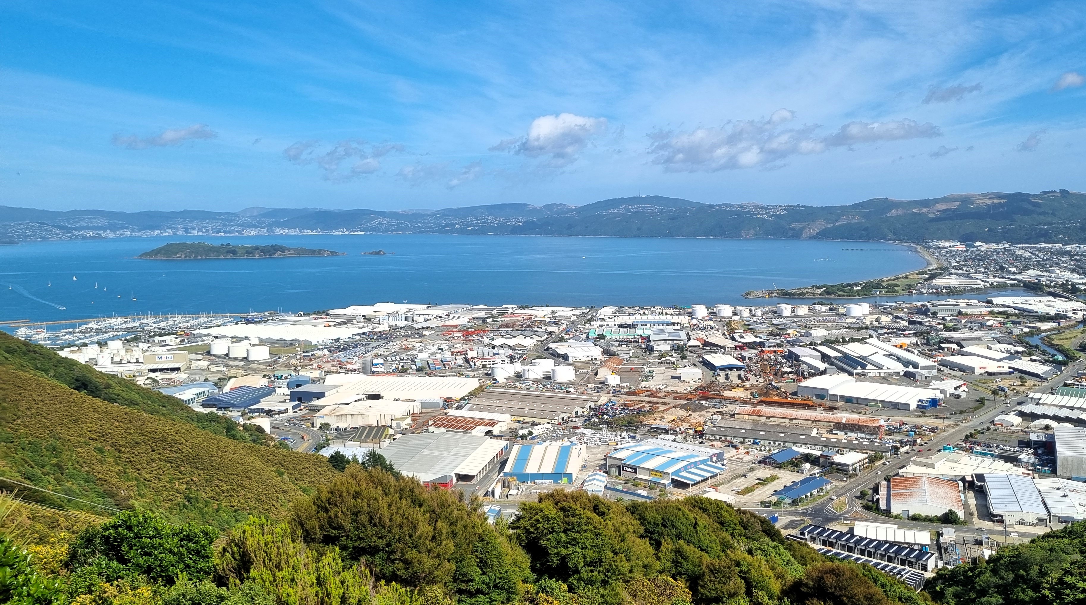
Petone (Māori language, Māori: ''Pito-one'') is a large suburb of Lower Hutt, Wellington, New Zealand. It stands at the southern end of the Hutt Valley, on the northern shore of Wellington Harbour. Europeans first settled in Petone in January 1840, making it the oldest European settlement in the Wellington Region. It became a borough in 1888, and merged with Lower Hutt (branded as "Hutt City") in 1989. Etymology The Māori language , Māori name means "an umbilical chord (''pito'') buried in the sand (''one'')", as a symbolic tethering of a newborn to the Tangata whenua, whenua (land) in Māori culture. On 6 September 2024, the Hutt City Council voted to officially rename "Pito One." This proposed name change was supported by the New Zealand Geographic Board, The Wellington Tenths Trust and the Palmerston North Māori Reserve Trust. On 19 December 2024, Minister for Land Information Chris Penk used his statutory ministerial powers to set aside the Hutt Council's decision to ... [...More Info...] [...Related Items...] OR: [Wikipedia] [Google] [Baidu] [Amazon] |
Petone Railway Station
Petone railway station is a dual platform, suburban railway station located in the Lower Hutt, New Zealand suburb of Petone. It is on the Hutt Valley Line, Hutt Valley section of the Wairarapa Line, north of Wellington railway station, Wellington, and is the junction for the Melling Branch to Melling railway station, Melling, which diverges westward from the main line to the north of the station. The station is served by Public transport in Wellington, Metlink suburban services, operated by Transdev Wellington, to Wellington, Melling, Taitā railway station, Taitā, Upper Hutt railway station, Upper Hutt and Masterton railway station, Masterton. The station has two side platforms, linked by a pedestrian subway to the south and a pedestrian overbridge to the north, which also links west over New Zealand State Highway 2, State Highway 2 to Pito-one Road. A small bus interchange connects buses from Maungaraki and Korokoro to trains to and from Wellington. Other facilities include ... [...More Info...] [...Related Items...] OR: [Wikipedia] [Google] [Baidu] [Amazon] |
Lower Hutt
Lower Hutt () is a list of cities in New Zealand, city in the Wellington Region of New Zealand. Administered by the Hutt City Council, it is one of the four cities that constitute the Wellington#Wellington metropolitan area, Wellington metropolitan area. It is New Zealand's List of cities in New Zealand, sixth most populous city, with a population of . The total area administered by the council is around the lower half of the Hutt Valley and along the eastern shores of Wellington Harbour, of which is urban. It is separated from the city of Wellington by the harbour, and from Upper Hutt by the Taita Gorge. Lower Hutt is unique among New Zealand cities, as the name of the council does not match the name of the city it governs. Special legislation has since 1991 given the council the name "Hutt City Council", while the name of the place itself remains "Lower Hutt City". This name has led to confusion, as Upper Hutt is administered by a separate city council, the Upper Hutt City C ... [...More Info...] [...Related Items...] OR: [Wikipedia] [Google] [Baidu] [Amazon] |
1976 Wellington Storm
The 1976 Wellington storm occurred between 20 and 23 December 1976 in the Wellington Region, Wellington region of New Zealand. The storm brought extreme rainfall to Wellington city and the Hutt Valley, and caused severe flooding, landslips, damage to homes, businesses and infrastructure and the death of one person. The event was caused by two moist airstreams coming from the north and south, which converged over the Hutt Valley and produced extremely heavy rainfall, mostly in a short period between midnight on 19 December through to the afternoon of 20 December. Heavy rain began falling in the Hutt Valley at about 4am on 20 December, from Pinehaven to Karori, and continued until about 2pm in Pinehaven and 4pm in Wellington city. The rainfall return period was the worst in 50 years, and in some parts of the affected area was the heaviest in 100 or possibly 500 years. Culverts and watercourses did not have the capacity to handle the volume of rainwater, and slips and mudflows brou ... [...More Info...] [...Related Items...] OR: [Wikipedia] [Google] [Baidu] [Amazon] |
Seaview, Lower Hutt
Seaview is an industrial suburb of the city of Lower Hutt, in Wellington, New Zealand. Situated on the eastern coast of the Hutt Valley, the suburb lies between Te Awa Kairangi / Hutt River, Te Awa Kairangi / the Hutt River and Petone (to the west), and the bays of Eastbourne, New Zealand, Eastbourne to the south. Seaview is a centre for bulk liquid fuel storage for the lower half of the North Island, and a site for heavy industry. It is also a base for support services for trucks and transportation businesses and the location of the Wastewater treatment, wastewater treatment plant for drainage from the Hutt Valley. Seaview is home to the Port Road Drags, the longest-running street drag races in Australasia. History In the first half of the nineteenth century there were two pā at Seaview. Ngāti Porou, Ngāti Ira people lived at a pā called Ohiti or Owhiti which was later taken over by Te Āti Awa. It was situated where the Ford factory would later be built. Te Āti Awa had ... [...More Info...] [...Related Items...] OR: [Wikipedia] [Google] [Baidu] [Amazon] |
Korokoro, New Zealand
Korokoro, a suburb of Lower Hutt City, lies in the south of the North Island of New Zealand. The suburb occupies part of the western hills of the Hutt Valley; its eastern slopes overlook Petone and the Wellington harbour. Korokoro was established in the 1900s by the Liberal government (in office 1891–1912), and remained a relatively small settlement until the Lower Hutt City Council developed the area for private housing in the 1960s. Before 1989, Korokoro formed part of the Petone Borough, which amalgamated with Lower Hutt City in that year. Demographics Korokoro statistical area covers . It had an estimated population of as of with a population density of people per km2. Korokoro had a population of 1,482 at the 2018 New Zealand census, an increase of 153 people (11.5%) since the 2013 census, and an increase of 198 people (15.4%) since the 2006 census. There were 540 households, comprising 744 males and 741 females, giving a sex ratio of 1.0 males per female. T ... [...More Info...] [...Related Items...] OR: [Wikipedia] [Google] [Baidu] [Amazon] |
Wellington Harbour
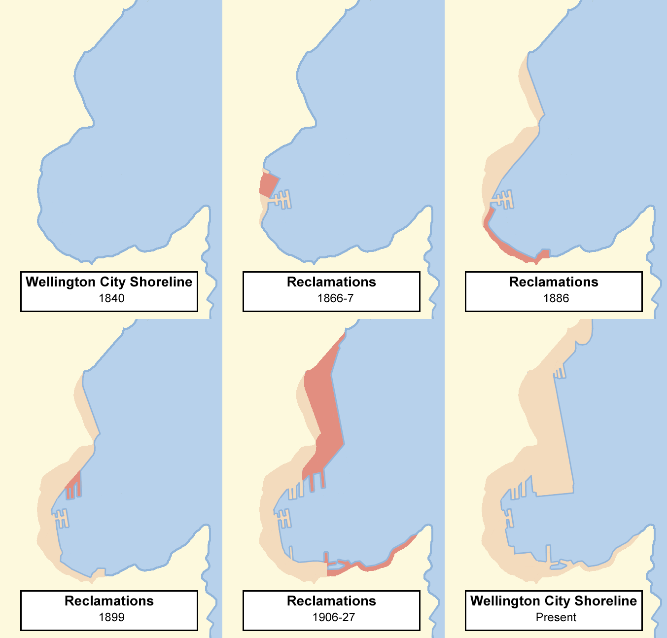
Wellington Harbour ( ), officially called Wellington Harbour / Port Nicholson, is a large natural harbour on the southern tip of New Zealand's North Island. The harbour entrance is from Cook Strait. Central Wellington is located on parts of the western and southern sides of the harbour, and the suburban area of Lower Hutt is to the north and east. The harbour area bounded by a line between Pencarrow Head to Petone foreshore, was officially named Port Nicholson until it assumed its current dual name in 1984. Toponymy The earliest known Māori name for the area, ''Te Upoko-o-te-Ika-a-Māui'', is derived from Māori legend and translates literally as "the head of Māui's fish". ''Te Whanganui-a-Tara'', another Māori name for the area, translates literally as "the great harbour of Tara". It is believed to refer to Tara, a son of the Polynesian explorer Whātonga, who was sent down from the Māhia Peninsula by his father to explore southern lands for their people to se ... [...More Info...] [...Related Items...] OR: [Wikipedia] [Google] [Baidu] [Amazon] |
Ava Railway Station
Ava railway station is a suburban railway station serving parts of Petone and Alicetown in Lower Hutt, New Zealand. It is located in a residential area bordering these two suburbs, north of Wellington, and is part of the Hutt Valley Line. Services are operated by Transdev Wellington on behalf of the Greater Wellington Regional Council. Trains stopping at Ava run to Wellington, Taitā and Upper Hutt. The station has an island platform between double tracks with a pedestrian overbridge at each end of the platform, connecting the station with Wakefield Street and Alicetown to the north, and North Street and Petone to the south. History The station was one of the three new stations on the then Hutt Valley Branch opened on 26 May 1927. Provisionally referred to as "the Cuba Street station", it was eventually named Ava after another nearby street. From 1 March 1954 with the closing of the Melling to Haywards section, this route became the main route to Upper Hutt and the Wairarapa ... [...More Info...] [...Related Items...] OR: [Wikipedia] [Google] [Baidu] [Amazon] |
Hutt River (New Zealand)
The Hutt River (, or ; officially Te Awa Kairangi / Hutt River) flows through the southern North Island of New Zealand. It flows south-west from the southern Tararua Range for , forming a number of fertile floodplains, including Kaitoke, central Upper Hutt and Lower Hutt. The Hutt River Trail, a regional park administered by Wellington Regional Council, runs alongside the eastern side of the river. Toponymy Early Māori residents, such as Ngāi Tara, called the river Te Awa Kairangi. Later Māori settlers named it Te Wai o Orutu after Orutu, a Ngāti Mamoe ancestor. By the time European settlers arrived, Māori called it Heretaunga, a name adopted by an Upper Hutt suburb and secondary school. The river was named ''Hutt'' after Sir William Hutt, chairman of the New Zealand Company. This name was given by Captain Edward Main Chaffers and Colonel William Wakefield while charting Port Nicholson in 1839. The official name since 2011 is Te Awa Kairangi / Hutt River. Geograph ... [...More Info...] [...Related Items...] OR: [Wikipedia] [Google] [Baidu] [Amazon] |
Chris Penk
Christopher Aidan Penk (born 1980) is a New Zealand politician who has been a Member of parliament, Member of Parliament in the New Zealand House of Representatives, House of Representatives for the New Zealand National Party, National Party since 2017. Early life and career Penk was born in West Auckland, New Zealand, West Auckland. He attended Kelston Boys' High School and graduated from the University of Auckland with a Bachelor of Arts in 1999 and a Bachelor of Laws with Honours in 2010. He joined the Royal New Zealand Navy, serving as an officer on HMNZS Te Kaha (F77), HMNZS ''Te Kaha''. He was an aide-de-camp for Governor-General Silvia Cartwright, before joining the Australian Defence Force for four years. After his military career, Penk became a property lawyer. His father, Stephen, is an Associate Dean at the University of Auckland's Law School and his brother Alex is also a lawyer. Penk's mother, Debra, was a teacher. Political career In August 2014, Penk was selecte ... [...More Info...] [...Related Items...] OR: [Wikipedia] [Google] [Baidu] [Amazon] |
Moera
Moera, a suburb of the city of Lower Hutt in New Zealand, forms part of the urban area of greater Wellington. Location Located at the south-eastern end of the Hutt River, the suburb's name Moera is thought to be a simplification of Moe-i-te-ra, meaning "sleeping in the sun". History Prior to European settlement, the Moera area was part of a large tidal estuary at the mouth of the Awamutu and Waiwhetū Streams. The southern side of Waiwhetū Stream contained a number of Ngati Ira villages. In 1843 William Trotter settled in the area and established a fruit garden and nursery. The 1855 Wairarapa earthquake raised the Hutt Valley from 1 to 2 metres, thus draining the swampy estuary. The area remained farmland up until 1926 when the Petone Railway Workshops were moved to Moera and Government sponsored prefabricated workers housing, built by the Railways Department, were sold to families. Influence To house workers almost 600 kitset homes were built to a simple 5 room lay ... [...More Info...] [...Related Items...] OR: [Wikipedia] [Google] [Baidu] [Amazon] |
Alicetown
Alicetown is a central suburb of Lower Hutt located at the bottom of the North Island of New Zealand. The suburb is situated north of the major suburb of Petone and west of the Lower Hutt CBD. Its boundaries are the Ewen Bridge that crosses the Hutt River, New Zealand to the east, the Western Hutt Rd/Melling Railway track to the west, Wakefield St/Hutt Railway track to the south and Railway Ave to the north. History and culture Aglionby, on what is now Tama Street, became the first European settlement in the Hutt Valley in 1840. The Aglionby Arms, the valley's first hotel, was built in Alicetown in 1840 and relocated in 1847. Alicetown began as a farming settlement and was settled from the early 1900s by Petone factory workers. Alicetown was named for Alice Maud Fitzherbert, the daughter of mayor William Fitzherbert who married Professor George William von Zedlitz in 1905. Te Tatau o Te Pō Marae was established in Alicetown in 1933. It is a ''marae'' (tribal meetin ... [...More Info...] [...Related Items...] OR: [Wikipedia] [Google] [Baidu] [Amazon] |
Horokiwi
Horokiwi is an outer northern suburb of Wellington. The area is semi-rural and there are no schools; most children attend schools in nearby Lower Hutt, and Primary School zoning is for Korokoro. The only feature other than houses and farms is Horokiwi Quarry. Access and roads The only access to Horokiwi is via Horokiwi Road, a road that climbs up a hill and branches off the Petone-Wellington motorway. There are only five streets/roads; Horokiwi Road, Hillcroft Road, Lincolnshire Road, Woollaston Way and Van Der Velden Way. The former runs for approximately 6.5 km, and the final kilometre eventually reaches Belmont Regional Park and becomes much more narrow. It also provides scenic views of Lower Hutt, Wellington Harbour, and other northern suburbs of Wellington such as Tawa and Grenada North. Since 2010 the only access to Horokiwi is from the northbound lane of the State Highway (SH2), causing around 8 km detours for residents travelling from North. ThCaribbean Ave ... [...More Info...] [...Related Items...] OR: [Wikipedia] [Google] [Baidu] [Amazon] |


