|
Pacific Ocean Areas (command)
Pacific Ocean Areas (POA) was a major Allied military command in the Pacific Ocean theater of World War II. It was one of four major Allied commands during the Pacific War and one of three United States commands in the Asiatic-Pacific Theater. Admiral Chester W. Nimitz of the U.S. Navy, Commander in Chief, U.S. Pacific Fleet, headed the command throughout its existence. The vast majority of Allied forces in the theatre were from the U.S. Navy, U.S. Army and U.S. Marine Corps. However units and/or personnel from New Zealand, the United Kingdom, Australia, Canada, Mexico, Fiji and other countries also saw active service. Formation and composition On 24 March 1942, the newly formed British and U.S. Combined Chiefs of Staff issued a directive designating the Pacific theater an area of American strategic responsibility. On 30 March the U.S. Joint Chiefs of Staff (JCS) divided the Pacific theater into three areas: the Pacific Ocean Areas (POA), the South West Pacific Area (SW ... [...More Info...] [...Related Items...] OR: [Wikipedia] [Google] [Baidu] |
Pacific Theater Areas;map1
The Pacific Ocean is the largest and deepest of Earth's five Borders of the oceans, oceanic divisions. It extends from the Arctic Ocean in the north to the Southern Ocean, or, depending on the definition, to Antarctica in the south, and is bounded by the continents of Asia and Australia in the west and the Americas in the east. At in area (as defined with a southern Antarctic border), the Pacific Ocean is the largest division of the World Ocean and the hydrosphere and covers approximately 46% of Earth's water surface and about 32% of the planet's total surface area, larger than its entire land area ().Pacific Ocean . ''Encyclopædia Britannica, Britannica Concise.'' 2008: Encyclopædia Britannica, Inc. The centers of both the Land and water hemispheres, water hemisphere and the Western Hemisphere, as well as the Pole of inaccessi ... [...More Info...] [...Related Items...] OR: [Wikipedia] [Google] [Baidu] |
Fiji
Fiji, officially the Republic of Fiji, is an island country in Melanesia, part of Oceania in the South Pacific Ocean. It lies about north-northeast of New Zealand. Fiji consists of an archipelago of more than 330 islands—of which about 110 are permanently inhabited—and more than 500 islets, amounting to a total land area of about . The most outlying island group is Ono-i-Lau. About 87% of the total population live on the two major islands, Viti Levu and Vanua Levu. About three-quarters of Fijians live on Viti Levu's coasts, either in the capital city of Suva, or in smaller urban centres such as Nadi (where tourism is the major local industry) or Lautoka (where the Sugarcane, sugar-cane industry is dominant). The interior of Viti Levu is sparsely inhabited because of its terrain. The majority of Fiji's islands were formed by Volcano, volcanic activity starting around 150 million years ago. Some geothermal activity still occurs today on the islands of Vanua Levu and ... [...More Info...] [...Related Items...] OR: [Wikipedia] [Google] [Baidu] |
South Pacific Area
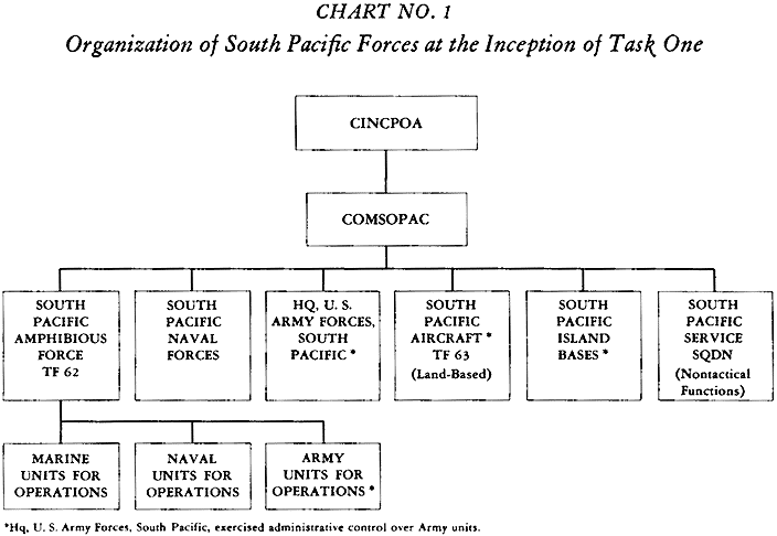
The South Pacific Area (SOPAC) was a multinational U.S.-led military command active during World War II. It was a part of the U.S. Pacific Ocean Areas under Admiral Chester Nimitz. The delineation and establishment of the Pacific Ocean Areas was negotiated by the Allied governments of the United States, the United Kingdom, Australia, New Zealand, and the Kingdom of the Netherlands in March–April 1942 in response to the Japanese attacks in Southeast Asia and the Pacific. The South Pacific Area was bounded on the west by the Southwest Pacific Area, on the north by the Central Pacific Area, and on the east by the Southeast Pacific Area. It originally encompassed the Ellice, Phoenix, Marquesas, Tuamotu, Samoa, Fiji, and New Hebrides island groups plus New Caledonia and New Zealand. Its western boundary was shifted to just west of Guadalcanal on 1 August 1942 to facilitate operations against that island. Background The assignment orders for Major General Millard Harmon as the ... [...More Info...] [...Related Items...] OR: [Wikipedia] [Google] [Baidu] |
03 1905 APR 1942 COMINCH-CINPAC
3 (three) is a number, numeral and digit. It is the natural number following 2 and preceding 4, and is the smallest odd prime number and the only prime preceding a square number. It has religious and cultural significance in many societies. Evolution of the Arabic digit The use of three lines to denote the number 3 occurred in many writing systems, including some (like Roman and Chinese numerals) that are still in use. That was also the original representation of 3 in the Brahmic (Indian) numerical notation, its earliest forms aligned vertically. However, during the Gupta Empire the sign was modified by the addition of a curve on each line. The Nāgarī script rotated the lines clockwise, so they appeared horizontally, and ended each line with a short downward stroke on the right. In cursive script, the three strokes were eventually connected to form a glyph resembling a with an additional stroke at the bottom: ३. The Indian digits spread to the Caliphate in the 9th ... [...More Info...] [...Related Items...] OR: [Wikipedia] [Google] [Baidu] |
Western Defense Command
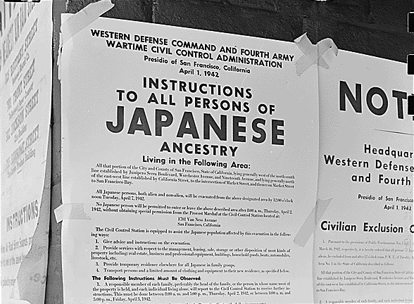
Western Defense Command (WDC) was established on 17 March 1941 as the command formation of the United States Army responsible for coordinating the defense of the West Coast of the United States, Pacific Coast region of the United States during World War II. A second major responsibility was the training of soldiers prior to their deployment overseas. The first Commanding General of WDC was Lieutenant General John L. DeWitt, who continued on in command of the Fourth United States Army, Fourth U.S. Army. WDC headquarters were co-located at the existing Fourth Army headquarters at the Presidio of San Francisco. WDC's operational region covered the states of Washington (U.S. state), Washington, Oregon, California, Idaho, Montana, Nevada, Utah, and Arizona, and the Territory of Alaska. Until 11 December 1941, the command was little more than a planning agency. On that date the Army Harbor Defense Command, coast defense, Army Antiaircraft Command, antiaircraft, and United States Army Air ... [...More Info...] [...Related Items...] OR: [Wikipedia] [Google] [Baidu] |
Alaska
Alaska ( ) is a non-contiguous U.S. state on the northwest extremity of North America. Part of the Western United States region, it is one of the two non-contiguous U.S. states, alongside Hawaii. Alaska is also considered to be the northernmost, westernmost, and easternmost (the Aleutian Islands cross the 180th meridian into the eastern hemisphere) state in the United States. It borders the Canadian territory of Yukon and the province of British Columbia to the east. It shares a western maritime border, in the Bering Strait, with Russia's Chukotka Autonomous Okrug. The Chukchi and Beaufort Seas of the Arctic Ocean lie to the north, and the Pacific Ocean lies to the south. Technically, it is a semi-exclave of the U.S., and is the largest exclave in the world. Alaska is the largest U.S. state by area, comprising more total area than the following three largest states of Texas, California, and Montana combined, and is the seventh-largest subnational division i ... [...More Info...] [...Related Items...] OR: [Wikipedia] [Google] [Baidu] |
Solomon Islands
Solomon Islands, also known simply as the Solomons,John Prados, ''Islands of Destiny'', Dutton Caliber, 2012, p,20 and passim is an island country consisting of six major islands and over 1000 smaller islands in Melanesia, part of Oceania, to the northeast of Australia. It is directly adjacent to Autonomous Region of Bougainville, Bougainville, a part of Papua New Guinea to the west, Australia to the southwest, New Caledonia and Vanuatu to the southeast, Fiji, Wallis and Futuna, and Tuvalu to the east, and Nauru and the Federated States of Micronesia to the north. It has a total area of 28,896 square kilometres (11,157 sq mi), and a population of 734,887 according to the official estimates for mid-2023. Its capital and largest city, Honiara, is located on the largest island, Guadalcanal. The country takes its name from the wider area of the Solomon Islands (archipelago), Solomon Islands archipelago, which is a collection of Melanesian islands that also includes the Autonomous ... [...More Info...] [...Related Items...] OR: [Wikipedia] [Google] [Baidu] |
Bismarck Archipelago
The Bismarck Archipelago (, ) is a group of islands off the northeastern coast of New Guinea in the western Pacific Ocean and is part of the Islands Region of Papua New Guinea. Its area is about . History The first inhabitants of the archipelago arrived around 30,000–40,000 years ago. They may have traveled from New Guinea, by boat across the Bismarck Sea or via a temporary land bridge, created by an uplift in the Earth's crust. Later arrivals included the Lapita people, the direct ancestors of the Austronesian peoples of Polynesia, eastern Micronesia, and Island Melanesia. The first European to visit these islands was Dutch explorer Willem Schouten in 1616. The islands remained unsettled by western Europeans until they were annexed as part of the German protectorate of German New Guinea in 1884. The area was named in honour of the Chancellor Otto von Bismarck. On 13 March 1888, a volcano erupted on Ritter Island causing a megatsunami. Almost the entire volcano fell int ... [...More Info...] [...Related Items...] OR: [Wikipedia] [Google] [Baidu] |
New Guinea
New Guinea (; Hiri Motu: ''Niu Gini''; , fossilized , also known as Papua or historically ) is the List of islands by area, world's second-largest island, with an area of . Located in Melanesia in the southwestern Pacific Ocean, the island is separated from Mainland Australia, Australia by the wide Torres Strait, though both landmasses lie on the same continental shelf, and were united during episodes of low sea level in the Pleistocene glaciations as the combined landmass of Sahul. Numerous smaller islands are located to the west and east. The island's name was given by Spanish explorer Yñigo Ortiz de Retez during his maritime expedition of 1545 due to the perceived resemblance of the indigenous peoples of the island to those in the Guinea (region), African region of Guinea. The eastern half of the island is the major land mass of the nation of Papua New Guinea. The western half, known as Western New Guinea, forms a part of Indonesia and is organized as the provinces of Pap ... [...More Info...] [...Related Items...] OR: [Wikipedia] [Google] [Baidu] |
Dutch East Indies
The Dutch East Indies, also known as the Netherlands East Indies (; ), was a Dutch Empire, Dutch colony with territory mostly comprising the modern state of Indonesia, which Proclamation of Indonesian Independence, declared independence on 17 August 1945. Following the Indonesian National Revolution, Indonesian War of Independence, Indonesia and the Netherlands Dutch–Indonesian Round Table Conference, made peace in 1949. In the Anglo-Dutch Treaty of 1824, the Dutch ceded the governorate of Dutch Malacca to Britain, leading to its eventual incorporation into Malacca, Malacca (state) of modern Malaysia. The Dutch East Indies was formed from the nationalised Factory (trading post), trading posts of the Dutch East India Company, which came under the administration of the Batavian Republic, Dutch government in 1800. During the 19th century, the Dutch fought Royal Netherlands East Indies Army, many wars against indigenous rulers and peoples, which caused hundreds of thousands of d ... [...More Info...] [...Related Items...] OR: [Wikipedia] [Google] [Baidu] |
Philippines
The Philippines, officially the Republic of the Philippines, is an Archipelagic state, archipelagic country in Southeast Asia. Located in the western Pacific Ocean, it consists of List of islands of the Philippines, 7,641 islands, with a total area of roughly 300,000 square kilometers, which are broadly categorized in Island groups of the Philippines, three main geographical divisions from north to south: Luzon, Visayas, and Mindanao. With a population of over 110 million, it is the world's List of countries and dependencies by population, twelfth-most-populous country. The Philippines is bounded by the South China Sea to the west, the Philippine Sea to the east, and the Celebes Sea to the south. It shares maritime borders with Taiwan to the north, Japan to the northeast, Palau to the east and southeast, Indonesia to the south, Malaysia to the southwest, Vietnam to the west, and China to the northwest. It has Ethnic groups in the Philippines, diverse ethnicities and Culture o ... [...More Info...] [...Related Items...] OR: [Wikipedia] [Google] [Baidu] |
Southeast Pacific Area
The Southeast Pacific Area was one of the designated area commands created by the Combined Chiefs of Staff in the Pacific region during World War II. It was responsible to the Joint Chiefs of Staff via the Commander-in-Chief of the United States Navy (COMINCH), Admiral Ernest King. Rear Admiral Abel T. Bidwell, former commander of Cruiser Division Three, commanded the Southeast Pacific Area during the first months of the war. History On 24 March 1942, the newly formed British and Combined Chiefs of Staff issued a directive designating the Pacific theater an area of American strategic responsibility. Six days later the Joint Chiefs of Staff (JCS) divided the Pacific theater into three areas: the Pacific Ocean Areas (POA), the Southwest Pacific Area (SWPA), and the Southeast Pacific Area. The Southeast Pacific Force, SoEastPac, was a small force of cruisers and destroyers based at Balboa, Panama which formed the main force operating in the Southeast Pacific Area. The Southeast Pacif ... [...More Info...] [...Related Items...] OR: [Wikipedia] [Google] [Baidu] |


