|
Nogales, AZ
Nogales (English: or , ; ) is a city in Santa Cruz County, Arizona. The population was 20,837 at the 2010 census and estimated 20,103 in 2019. Nogales forms part of the larger Tucson–Nogales combined statistical area, with a total population of 1,027,683 as of the 2010 Census. The city is the county seat of Santa Cruz County. Nogales forms Arizona's largest transborder agglomeration with its adjacent, much larger twin Nogales, Sonora, across the Mexican border. The southern terminus of Interstate 19 is located in Nogales at the U.S.–Mexico border; the highway continues south into Mexico as Mexico Federal Highway 15. The highways meeting in Nogales are a major road intersection in the CANAMEX Corridor, connecting Canada, the United States, and Mexico. Nogales also is the beginning of the Arizona Sun Corridor, an economically important trade region stretching from Nogales to Prescott, including the Tucson and Phoenix metropolitan areas. Nogales is home to four internationa ... [...More Info...] [...Related Items...] OR: [Wikipedia] [Google] [Baidu] |
City
A city is a human settlement of notable size.Goodall, B. (1987) ''The Penguin Dictionary of Human Geography''. London: Penguin.Kuper, A. and Kuper, J., eds (1996) ''The Social Science Encyclopedia''. 2nd edition. London: Routledge. It can be defined as a permanent and densely settled place with administratively defined boundaries whose members work primarily on non-agricultural tasks. Cities generally have extensive systems for housing, transportation, sanitation, utilities, land use, production of goods, and communication. Their density facilitates interaction between people, government organisations and businesses, sometimes benefiting different parties in the process, such as improving efficiency of goods and service distribution. Historically, city-dwellers have been a small proportion of humanity overall, but following two centuries of unprecedented and rapid urbanization, more than half of the world population now lives in cities, which has had profound consequences for g ... [...More Info...] [...Related Items...] OR: [Wikipedia] [Google] [Baidu] |
Juglans Major
''Juglans major'' (literally, the larger walnut), also known as Arizona walnut, is a walnut tree which grows to with a DBH of up to at elevations of in Texas, Oklahoma, New Mexico, Arizona, and Utah. It also occurs in Mexico as far south as Guerrero. Common names include Arizona black walnut (as it belongs to the "black walnuts" section ''Juglans'' sect. ''Rhysocaryon''), and the Spanish name ''nogal cimarrón'' (cimarron walnut). Description In moister areas, the tree features a single, stout trunk; there are usually several slender trunks in drier situations. The 8–14 in long pinnately compound leaves bear 9–15 lanceolate leaflets, wide by long. The small nut has a thick shell with deep grooves enclosing an oily, edible seed. Where the range of ''J. major'' overlaps that of '' J. microcarpa'', the two interbreed, producing many intermediate forms.Powell, A. Michael. (1988). ''Trees & shrubs of Trans-Pecos Texas including Big Bend and Guadalupe Mounta ... [...More Info...] [...Related Items...] OR: [Wikipedia] [Google] [Baidu] |
Tucson, Arizona
, "(at the) base of the black ill , nicknames = "The Old Pueblo", "Optics Valley", "America's biggest small town" , image_map = , mapsize = 260px , map_caption = Interactive map outlining Tucson , image_map1 = File:Pima County Incorporated and Unincorporated areas Tucson highlighted.svg , mapsize1 = 250px , map_caption1 = Location within Pima County , pushpin_label = Tucson , pushpin_map = USA Arizona#USA , pushpin_map_caption = Location within Arizona##Location within the United States , subdivision_type = Country , subdivision_type1 = State , subdivision_type2 = County , subdivision_name = United States , subdivision_name1 = Arizona , subdivision_name2 = Pima , established_title = Founded , established_date = August 20, 1775 , established_title1 = Incorporated , e ... [...More Info...] [...Related Items...] OR: [Wikipedia] [Google] [Baidu] |
Prescott, Arizona
Prescott ( ) is a city in Yavapai County, Arizona, United States. According to the 2020 Census, the city's population was 45,827. The city is the county seat of Yavapai County. In 1864, Prescott was designated as the capital of the Arizona Territory, replacing the temporary capital of Fort Whipple. The Territorial Capital was moved to Tucson in 1867. Prescott again became the Territorial Capital in 1877, until Phoenix became the capital in 1889. Prescott has a rich history as a frontier gold and silver mining town. Mining and settlers brought frequent conflict with native American tribes in the area, including the Yavapai and Apache. Prescott was the home to Fort Whipple from its inception, which acted as a base for campaigns against natives. Prescott was a stereotypical "wild west" town during the latter half of the 19th century; famous residents included Doc Holliday and Virgil Earp of the gunfight at the O.K. Corral. The makeshift wooden town burned to the ground sever ... [...More Info...] [...Related Items...] OR: [Wikipedia] [Google] [Baidu] |
Arizona Sun Corridor
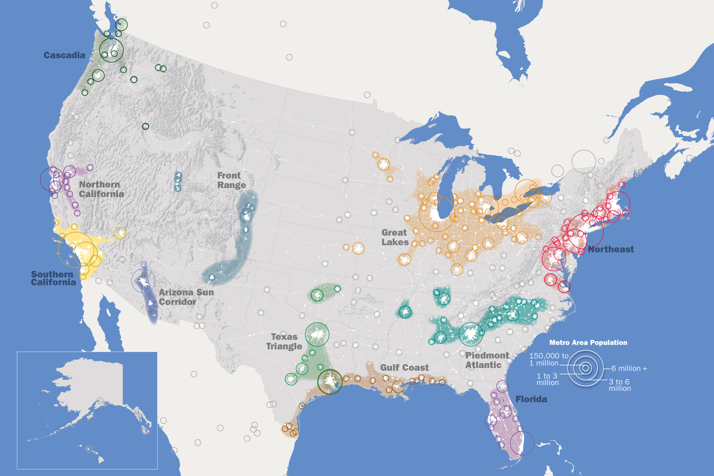
The Arizona Sun Corridor, shortened Sun Corridor, is a megaregion, or megapolitan area, in the southern area of the U.S. state of Arizona. The Sun Corridor is comparable to Indiana in both size and population. It is one of the fastest growing conurbations in the country and is speculated to double its population by 2040. The largest metropolitan areas are the Phoenix metropolitan area – Valley of the Sun, and the Tucson metropolitan area – The Old Pueblo. The regions' populace is nestled in the valley of a desert environment. Similar to Southern California, the urban area extends into Mexico, reaching the communities of Nogales and Agua Prieta. Its population is composed of five metropolitan areas: Phoenix, Tucson, Prescott, Sierra Vista-Douglas and Nogales. Of these, two are metropolitan areas with over 1,000,000 residents: the Phoenix metropolitan area with 4.85 million residents and the Tucson metropolitan area with over 1 million residents. The Arizona Sun Corridor i ... [...More Info...] [...Related Items...] OR: [Wikipedia] [Google] [Baidu] |
CANAMEX Corridor
The CANAMEX corridor is a series of improvements to freeways and other transportation infrastructure linking Canada to Mexico through the United States. The corridor was established under the North American Free Trade Agreement. Currently the corridor is defined by a series of highways. However, the corridor is also proposed for use by railroads and fiber optic telecommunications infrastructure. Origin While the tri-lateral corridor was defined in NAFTA, the U.S. portion of CANAMEX Trade Corridor was outlined in 1991 in the "ISTEA" highway bill, and defined by Congress in the 1995 National Highway Systems Designation Act, Public Law 104-59, November 28, 1995. Route description The CANAMEX corridor is defined by the numbered highway designations along its length: Canada *British Columbia ** Highway 97 (Alaska Highway) ** Highway 2 - Dawson Creek to Alberta border *Alberta ** Highway 43 - British Columbia border to Highway 16 ** Highway 16 - to Edmonton ** Highw ... [...More Info...] [...Related Items...] OR: [Wikipedia] [Google] [Baidu] |
Mexico Federal Highway 15
Federal Highway 15 ( es, Carretera Federal 15, Fed. 15 ) is Mexico 15 International Highway or Mexico- Nogales Highway, is a primary north-south highway, and is a free part of the federal highways corridors ( es, los corredores carreteros federales) of Mexico. The highway begins in the north at the Mexico–United States border at the Nogales Port of Entry in Nogales, Sonora, and terminates to the south in Mexico City. Fed. 15 from Nogales to Mazatlán runs parallel to Fed. 15D, a tolled (cuota) part of the federal highways corridors (los corredores carreteros federales); the portion of this northern stretch from the town of Eldorado southward within the Sinaloa is a limited-access highway."Rand McNally Road Atlas", Rand McNally & Company, 1998, p. 120 North of the U.S.-Mexico border, the highway continues to the north from the Port of Entry, as I-19 Business. The highway is the southern terminus of the CANAMEX Corridor, a trade corridor that stretches from Me ... [...More Info...] [...Related Items...] OR: [Wikipedia] [Google] [Baidu] |


