|
Natural Regions Of Germany
This division of Germany into major natural regions takes account primarily of geomorphological, geological, hydrological, and pedological criteria in order to divide the country into large, physical units with a common geographical basis. Political boundaries play no part in this, apart from defining the national border. In addition to a division of Germany by ''natural regions'', the federal authorities have also produced a division by so-called ''landscape areas (Landschaftsräume)'' that is based more on human utilisation of various regions and so has clearly different boundaries. Groundwork by the Federal Institute of Regional Studies (BfL) The natural region classification of Germany, as used today by the Federal Office for Nature Conservation (''Bundesamt für Naturschutz'' or BfN) and by most state institutions, is largely based on the work in producing the Handbook of Natural Region Divisions of Germany between the years 1953 to 1962. This divided the present federal ... [...More Info...] [...Related Items...] OR: [Wikipedia] [Google] [Baidu] |
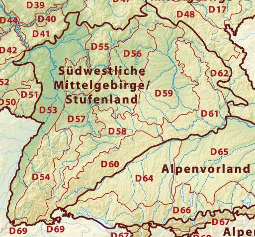
South German Scarplands
The South German Scarplands is a geological and geomorphological natural region or landscape in Switzerland and the south German states of Bavaria and Baden-Württemberg. The landscape is characterised by escarpments. It is variously referred to in the German literature as the: * ' (Southwest German Scarplands) * ' (Southwest German Scarp Landscape) * ' (Swabian-Franconian Scarpland(scape)) * ' (South German Scarpland(scape)) Location and short description The South German Scarplands run (from north(-northeast) to south(-southwest)) more or less between the southern Rhön, the Spessart, the Odenwald and the Black Forest in the west, the Franconian Jura in the east, the Swabian Jura to the southeast and the northeastern foothills of the Jura to the south. The wooded west and northwest-facing scarps drop sharply towards the Rhine Rift Valley and the Rhine-Main Plain, whilst the dip slopes fall comparatively gradually towards the (north-)east into the depressions beyond ... [...More Info...] [...Related Items...] OR: [Wikipedia] [Google] [Baidu] |
Natural Regions Of Saxony
The classification of natural regions of Saxony shown here was produced between 1994 and 2001 by a working group called "Ecosystem and Regional Character" (''Naturhaushalt und Gebietscharakter'') at the Saxonian Academy of Sciences in Leipzig as part of the research and development project "Natural Regions and Natural Region Potential of the Free State of Saxony" (''Naturräume und Naturraumpotentiale des Freistaates'') at a scale of 1:50,000 as the basis for the rural development and regional planning. This was also supported by the Saxon State Ministry of the Environment and Agriculture and the Saxon Ministry of the Interior. The basis of the structure was a comprehensive, statewide compilation of the smallest physical geographic landscape units (physiotopes). These were aggregated into larger units ( nano-geochores and micro-geochores) in an orderly way using the method of "natural region categories". For each of the micro-geochores that resulted from this, a 9-page document wa ... [...More Info...] [...Related Items...] OR: [Wikipedia] [Google] [Baidu] |
North And Baltic Seas
North is one of the four compass points or cardinal directions. It is the opposite of south and is perpendicular to east and west. ''North'' is a noun, adjective, or adverb indicating direction or geography. Etymology The word ''north'' is related to the Old High German ''nord'', both descending from the Proto-Indo-European unit *''ner-'', meaning "left; below" as north is to left when facing the rising sun. Similarly, the other cardinal directions are also related to the sun's position. The Latin word ''borealis'' comes from the Greek '' boreas'' "north wind, north", which, according to Ovid, was personified as the wind-god Boreas, the father of Calais and Zetes. ''Septentrionalis'' is from ''septentriones'', "the seven plow oxen", a name of ''Ursa Major''. The Greek ἀρκτικός (''arktikós'') is named for the same constellation, and is the source of the English word ''Arctic''. Other languages have other derivations. For example, in Lezgian, ''kefer'' can mean ... [...More Info...] [...Related Items...] OR: [Wikipedia] [Google] [Baidu] |
Alpine Foreland
The Alpine Foreland, less commonly called the Bavarian Foreland,Dickinson, Robert E (1964). ''Germany: A regional and economic geography'' (2nd ed.). London: Methuen, pp. 585-586. . Bavarian Plateau or Bavarian Alpine Foreland (german: Bayerisches Alpenvorland), refers to a triangular region of plateau and rolling foothills in Southern Germany, stretching from Lake Constance in the west to beyond Linz on the Danube in the east, with the Bavarian Alps forming its south boundary and the Danube its northern extent. Geography The Alpine Foreland has been shaped under the influence of the ice ages and has a rich variety of landforms. A molasse basin of extensive Tertiary and Quaternary sediments — silt and clay, sand and sedimentary rocks from Alpine erosion— overlay the Alpine nappes. Features such as the morainic hills, gravel sandar and lakes have left a record of various glaciation stages in this region. The Alpine Foreland is crossed by the rivers Iller, Wertach, L ... [...More Info...] [...Related Items...] OR: [Wikipedia] [Google] [Baidu] |
Eastern Central Uplands
Eastern may refer to: Transportation *China Eastern Airlines, a current Chinese airline based in Shanghai * Eastern Air, former name of Zambia Skyways * Eastern Air Lines, a defunct American airline that operated from 1926 to 1991 *Eastern Air Lines (2015), an American airline that began operations in 2015 *Eastern Airlines, LLC, previously Dynamic International Airways, a U.S. airline founded in 2010 *Eastern Airways, an English/British regional airline *Eastern Provincial Airways, a defunct Canadian airline that operated from 1949 to 1986 *Eastern Railway (other), various railroads * Eastern Avenue (other), various roads *Eastern Parkway (other), various parkways *Eastern Freeway, Melbourne, Australia *Eastern Freeway Mumbai, Mumbai, India *, a cargo liner in service 1946-65 Education *Eastern University (other) * Eastern College (other) Other uses * Eastern Broadcasting Limited, former name of Maritime Broadcasting System, Cana ... [...More Info...] [...Related Items...] OR: [Wikipedia] [Google] [Baidu] |
Western Central Uplands
Western may refer to: Places *Western, Nebraska, a village in the US *Western, New York, a town in the US * Western Creek, Tasmania, a locality in Australia *Western Junction, Tasmania, a locality in Australia *Western world, countries that identify with shared "Western" culture Arts and entertainment Films * ''Western'' (1997 film), a French road movie directed by Manuel Poirier * ''Western'' (2017 film), a German-Austrian film Genres *Western (genre), a category of fiction and visual art centered on the American Old West **Western fiction, the Western genre as featured in literature **Western music (North America), a type of American folk music Music * ''Westerns'' (EP), an EP by Pete Yorn *WSTRN, a British hip hop group from west London Business *The Western, a closed hotel/casino in Las Vegas, United States *Western Cartridge Company, a manufacturer of ammunition *Western Publishing, a defunct publishing company Educational institutions *Western Washington University ... [...More Info...] [...Related Items...] OR: [Wikipedia] [Google] [Baidu] |
Northwest German Plain
The North German Plain or Northern Lowland (german: Norddeutsches Tiefland) is one of the major geographical regions of Germany. It is the German part of the North European Plain. The region is bounded by the coasts of the North Sea and the Baltic Sea to the north, Germany's Central Uplands (''die Mittelgebirge'') to the south, by the Netherlands to the west and Poland to the east. In the west, the southern boundary of the North German Plain is formed by the Lower Saxon Hills: specifically the ridge of the Teutoburg Forest, the Wiehen Hills, the Weser Hills and the Lower Saxon Börde, which partly separate it from that area of the Plain known as the Westphalian Lowland. Elements of the Rhenish Massif also act a part of the southern boundary of the plain: the Eifel, Bergisches Land and the Sauerland. In the east the North German Plain spreads out beyond the Harz Mountains and Kyffhäuser further to the south as far as the Central Saxon hill country and the foothills of the Ore ... [...More Info...] [...Related Items...] OR: [Wikipedia] [Google] [Baidu] |
Northeast German Plain
The points of the compass are a set of horizontal, radially arrayed compass directions (or azimuths) used in navigation and cartography. A compass rose is primarily composed of four cardinal directions—north, east, south, and west—each separated by 90 degrees, and secondarily divided by four ordinal (intercardinal) directions—northeast, southeast, southwest, and northwest—each located halfway between two cardinal directions. Some disciplines such as meteorology and navigation further divide the compass with additional azimuths. Within European tradition, a fully defined compass has 32 'points' (and any finer subdivisions are described in fractions of points). Compass points are valuable in that they allow a user to refer to a specific azimuth in a colloquial fashion, without having to compute or remember degrees. Designations The names of the compass point directions follow these rules: 8-wind compass rose * The four cardinal directions are north (N), east (E) ... [...More Info...] [...Related Items...] OR: [Wikipedia] [Google] [Baidu] |
Natural Regions In Saxony
The classification of natural regions of Saxony shown here was produced between 1994 and 2001 by a working group called "Ecosystem and Regional Character" (''Naturhaushalt und Gebietscharakter'') at the Saxonian Academy of Sciences in Leipzig as part of the research and development project "Natural Regions and Natural Region Potential of the Free State of Saxony" (''Naturräume und Naturraumpotentiale des Freistaates'') at a scale of 1:50,000 as the basis for the rural development and regional planning. This was also supported by the Saxon State Ministry of the Environment and Agriculture and the Saxon Ministry of the Interior. The basis of the structure was a comprehensive, statewide compilation of the smallest physical geographic landscape units (physiotopes). These were aggregated into larger units ( nano-geochores and micro-geochores) in an orderly way using the method of "natural region categories". For each of the micro-geochores that resulted from this, a 9-page document wa ... [...More Info...] [...Related Items...] OR: [Wikipedia] [Google] [Baidu] |
Alps
The Alps () ; german: Alpen ; it, Alpi ; rm, Alps ; sl, Alpe . are the highest and most extensive mountain range system that lies entirely in Europe, stretching approximately across seven Alpine countries (from west to east): France, Switzerland, Italy, Liechtenstein, Austria, Germany, and Slovenia. The Alpine arch generally extends from Nice on the western Mediterranean to Trieste on the Adriatic and Vienna at the beginning of the Pannonian Basin. The mountains were formed over tens of millions of years as the African and Eurasian tectonic plates collided. Extreme shortening caused by the event resulted in marine sedimentary rocks rising by thrust fault, thrusting and Fold (geology), folding into high mountain peaks such as Mont Blanc and the Matterhorn. Mont Blanc spans the French–Italian border, and at is the highest mountain in the Alps. The Alpine region area contains 128 peaks higher than List of Alpine four-thousanders, . The altitude and size of the range af ... [...More Info...] [...Related Items...] OR: [Wikipedia] [Google] [Baidu] |


