|
Niederschönhausen
Niederschönhausen (, literally "Lower Schönhausen") is a locality (''Ortsteil'') within the borough (''Bezirk'') of Pankow in Berlin, Germany. It is also known as "Pankow-Schönhausen" to differ it from Hohenschönhausen in Berlin- Lichtenberg. From 1949 until 1960 Schönhausen Palace and the adjacent Majakowskiring quarter were the residence of several members of the East German government, commonly referred to as ''Pankow'' by the West German media. Geography Overview Located north of the Berlin city centre, Niederschönhausen borders with the localities of Wilhelmsruh, Rosenthal in the north, Französisch Buchholz in the east, Pankow in the south and the Reinickendorf locality (in the homonymous borough) along the Berlin Northern Railway line in the west. The locality comprises several green areas, as the Schönholzer Heide, the Brosepark, the Schlosspark Pankow, the Bürgerpark and the cemetery Friedhof Pankow III. Subdivision Niederschönhausen is divided into 3 ... [...More Info...] [...Related Items...] OR: [Wikipedia] [Google] [Baidu] |
Schönhausen Palace
Schönhausen Palace (german: Schloss Schönhausen) is a Baroque palace at Niederschönhausen, in the borough of Pankow, Berlin, Germany. It is surrounded by gardens through which the Panke river runs. The palace is maintained by the Prussian Palaces and Gardens Foundation Berlin-Brandenburg and reopened to the public in 2009 after extensive restoration. History Brandenburg-Prussia In 1662 Countess Sophie Theodore, a scion of the Holland- Brederode family and wife of the Brandenburg general Christian Albert of Dohna, acquired the lands Niederschönhausen and Pankow, then far north of the Berlin city gates. In 1664 she built a manor at Niederschönhausen in "Dutch" style. Minister Joachim Ernst von Grumbkow acquired it in 1680 and, in 1691, his widow sold it for 16,000 Thalers to the Hohenzollern elector Frederick III of Brandenburg, who had fallen in love with the property earlier. Frederick put the manor under the care of the ''Amt'' Niederschönhausen and had it remo ... [...More Info...] [...Related Items...] OR: [Wikipedia] [Google] [Baidu] |
Berlin Tram
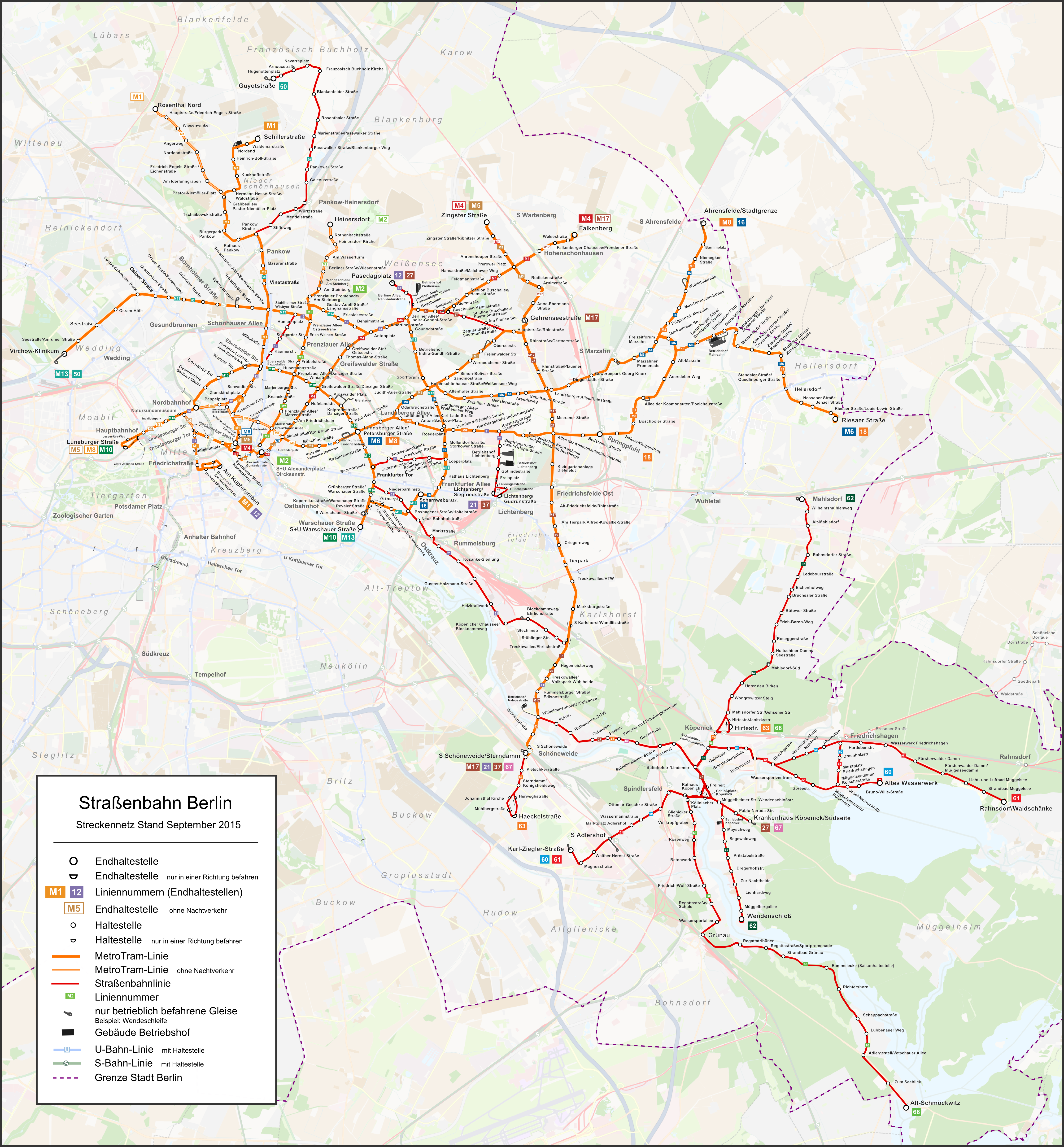
The Berlin tramway (german: Straßenbahn Berlin) is the main tram system in Berlin, Germany. It is one of the oldest tram networks in the world having its origins in 1865 and is operated by (BVG), which was founded in 1929. It is notable for being the third-largest tram system in the world, after Melbourne and St. Petersburg. Berlin's tram system is made up of 22 lines that operate across a standard gauge network, with almost 800 stops and measuring almost in route length and in line length. Nine of the lines, called Metrotram, operate 24 hours a day and are identified with the letter "M" before their number; the other thirteen lines are regular city tram lines and are identified by just a line number. Most of the recent network is within the confines of the former East Berlin—tram lines within West Berlin having been replaced by buses during the division of Berlin. However the first extension into West Berlin opened in 1994 on today's M13. In the eastern v ... [...More Info...] [...Related Items...] OR: [Wikipedia] [Google] [Baidu] |
Pankow (locality)
Pankow () is a locality (''Ortsteil'') of Berlin in the district (''Bezirk'') of Pankow. Until 2001 it was an autonomous district with the localities of Karow, Niederschönhausen, Wilhelmsruh, Rosenthal, Blankenfelde, Buch and Französisch Buchholz. History The village of Pankow is named after the small Panke river, a tributary of the Spree. The settlement was first mentioned in a 1311 deed by the Margraves of Brandenburg, though the " Four Evangelists" fieldstone church had already been erected about 1230. In 1691 Elector Frederick III acquired Schönhausen Palace, in neighboring Niederschönhausen, from the heirs of General Joachim Ernst von Grumbkow, which promoted the development of the Pankow village. As Pankow grew, due to industrialization, in the 19th century, it became a suburb – and popular day-trip destination – of Berlin. It was finally incorporated into the city by the Greater Berlin Act of 1920. In the East German period, from 1949 t ... [...More Info...] [...Related Items...] OR: [Wikipedia] [Google] [Baidu] |
Pankow
Pankow () is the most populous and the second-largest borough by area of Berlin. In Berlin's 2001 administrative reform, it was merged with the former boroughs of Prenzlauer Berg and Weißensee; the resulting borough retained the name Pankow. Pankow was sometimes claimed by the Western Allies (United States, United Kingdom, and France) to be the capital of the German Democratic Republic (East Germany), while the German Democratic Republic itself considered East Berlin to be its capital. Overview The borough, named after the Panke river, covers the northeast of the city region, including the inner city locality of Prenzlauer Berg. It borders Mitte and Reinickendorf in the west, Friedrichshain-Kreuzberg in the south, and Lichtenberg in the east. Pankow is Berlin's largest borough by population and the second largest by area (after Treptow-Köpenick). Between 1945 and 1960, Schönhausen Palace and the nearby Majakowskiring street in the Niederschönhausen locality of Pan ... [...More Info...] [...Related Items...] OR: [Wikipedia] [Google] [Baidu] |
Französisch Buchholz
Französisch Buchholz (), also known simply as Buchholz, is a German locality (''Ortsteil'') within the Berlin borough (''Bezirk'') of Pankow. History First mentioned in 1242 as ''Buckholtz'' in a document, it became the property of Frederick William I in 1670. In 1685, after the Edict of Potsdam, it was formed as a French colony (''Französische Kolonie''), a residence for French Huguenots. An autonomous municipality of Brandenburg, named ''Berlin-Buchholz'' after 1913, it was merged into Berlin in 1920 by the "Greater Berlin Act". From 1949 to 1990 it was part of East Berlin. Geography Located in the northern suburbs of the city, but totally surrounded by the territory of Berlin, Buchholz borders on Buch, Karow, Blankenburg, Pankow, Niederschönhausen, Rosenthal and Blankenfelde. In the north of the quarter is situated the natural reserve "'' Karower Teiche''", part of the Barnim Nature Park. [...More Info...] [...Related Items...] OR: [Wikipedia] [Google] [Baidu] |
Boroughs And Localities Of Berlin
Berlin is both a city and one of Germany’s federated states ( city state). Since the 2001 administrative reform, it has been made up of twelve districts (german: Bezirke, ), each with its own administrative body. However, unlike the municipalities and counties of other German states, the Berlin districts are not territorial corporations of public law () with autonomous competencies and property, but simple administrative agencies of Berlin's state and city government, the City of Berlin forming a single municipality () since the Greater Berlin Act of 1920. Thus they cannot be equated to US or UK boroughs in the traditional meaning of the term. Each district possesses a district representatives' assembly () directly elected by proportional representation and an administrative body called district board (). The district board, comprising since October 2021 six (until then five) members - a district mayor () as head and five (earlier four) district councillors () - is elected by ... [...More Info...] [...Related Items...] OR: [Wikipedia] [Google] [Baidu] |
Alt-Hohenschönhausen
Alt-Hohenschönhausen (, literally ''Old Hohenschönhausen'') is a quarter (''Ortsteil'') in the borough (''Bezirk'') of Lichtenberg, Berlin. Known also as Hohenschönhausen it was, until 2001, the main and the eponymous locality of the former Hohenschönhausen borough. In 2008 the population was in excess of 41,000. History Early history The earliest evidence of settlement in Alt-Hohenschönhausen are from the Bronze Age, and when the settlement history of the wider Berlin area is taken into consideration, there could have been settlements there since 10,000BC. Alt-Hohenschönhausen was first mentioned in 1230. In the initial centuries of the Common Era the area was mainly inhabited by the Sprevane and Hevelli tribes. By the 13th century the area had been colonised by Germans, particularly from the settlement of Schönhausen, during the eastward migration and settlement of Germans in the medieval period. By the 14th century, the prefix ''Hoh'' (high) was added to the name of the ... [...More Info...] [...Related Items...] OR: [Wikipedia] [Google] [Baidu] |
Majakowskiring
The Majakowskiring (named after Vladimir Mayakovsky) is an ellipse-shaped street in the Pankow district of Berlin, Germany, in the Niederschönhausen locality. It was famous as the residence of many senior figures in the government of the German Democratic Republic. The ''Majakowskiring'' neighbourhood (''Ortslage'') is situated between Grabbeallee to the west and northwest, Ossietzkystraße and Schlosspark to the east, Schloss Schönhausen to the northeast, and the Panke river to the south. History Until 4 May 1950, the northern section was called Kronprinzenstraße and the southern section Viktoriastraße. It was then renamed after the Russian poet Vladimir Mayakovski. For a short time it was called Majakowskistraße. Most of the houses were built in the 1920s and are mainly mansions which were inhabited by industrialists and artists, until the most of them were expropriated after the Second World War. In exceptional cases the former owners were allowed to remain if they con ... [...More Info...] [...Related Items...] OR: [Wikipedia] [Google] [Baidu] |
Reinickendorf (locality)
Reinickendorf () is a locality () of Berlin in the borough () of Reinickendorf. It had a population of 83,972 in 2020. Geography The locality is situated in the south-western side of its district. It borders the localities of Tegel in the west, Wittenau and Borsigwalde in the north. To the east are Wilhelmsruh, Niederschönhausen and Pankow, all three in the Pankow borough, to the south Gesundbrunnen and Wedding, both in the borough of Mitte. History The name of the former Reinickendorf village can be traced back to a peasant ''Reinhardt'' (''Reineke'' in Low German), who settled here around 1230. The locality was first mentioned in a 1345 deed and acquired by the City of Berlin in 1397. The late 19th century saw a significant increase in population, when Reinickendorf received direct access to Berlin with the opening of the ''Nordbahn'' railway line to Neustrelitz in 1877. Reinickendorf was incorporated into the City of Berlin by the 1920 Greater Berlin Act. In 1928, archit ... [...More Info...] [...Related Items...] OR: [Wikipedia] [Google] [Baidu] |
Wilhelmsruh
Wilhelmsruh () is a German locality (''Ortsteil'') within the borough (''Bezirk'') of Pankow, Berlin. It is the city's smallest locality, after Halensee and Hansaviertel. History In the locality, originally part of Rosenthal, it was built a country house named ''Nordend'' which received occasionally the designation name ''Rosenthal II''. In 1892 the settlement received the name of ''Colonie Wilhelmsruh''. As part of Nordend municipality (now a zone of Rosenthal), it merged into Berlin in 1920 with the "Greater Berlin Act". During the "Cold War" it was part of East Berlin bordering with the western sector, and it was crossed by the Berlin Wall from 1961 to 1989. Geography Wilhelmsruh is located in the northern suburb of Berlin, in a corner of Pankow district surrounded by Rosenthal, Niederschönhausen, Reinickendorf and Märkisches Viertel (both in Reinickendorf district). Its western corner is close to Wittenau but it doesn't borders with this locality. In its territory, Wilhe ... [...More Info...] [...Related Items...] OR: [Wikipedia] [Google] [Baidu] |
Nordend (Berlin)
Nordend (meaning ''north end'' in German) is a northern peak of the Monte Rosa Massif. Nordend is the fourth highest peak of the massif, after the Dufourspitze (4,634 m), the Dunantspitze (4,632 m) and the Grenzgipfel (4,618 m). See also *List of Alpine four-thousanders This list tabulates all of the 82 official mountain summits of or more in height in the Alps, as defined by the International Climbing and Mountaineering Federation (UIAA). All are located within France, Italy or Switzerland, and are often refer ... External links Nordend on Summitpost Mountains of the Alps Alpine four-thousanders Mountains of Valais Mountains of Piedmont Pennine Alps Italy–Switzerland border International mountains of Europe Monte Rosa Mountains of Switzerland Four-thousanders of Switzerland {{VerbanoCusioOssola-mountain-stub ... [...More Info...] [...Related Items...] OR: [Wikipedia] [Google] [Baidu] |
.jpg)


