|
Nevada County, Arkansas
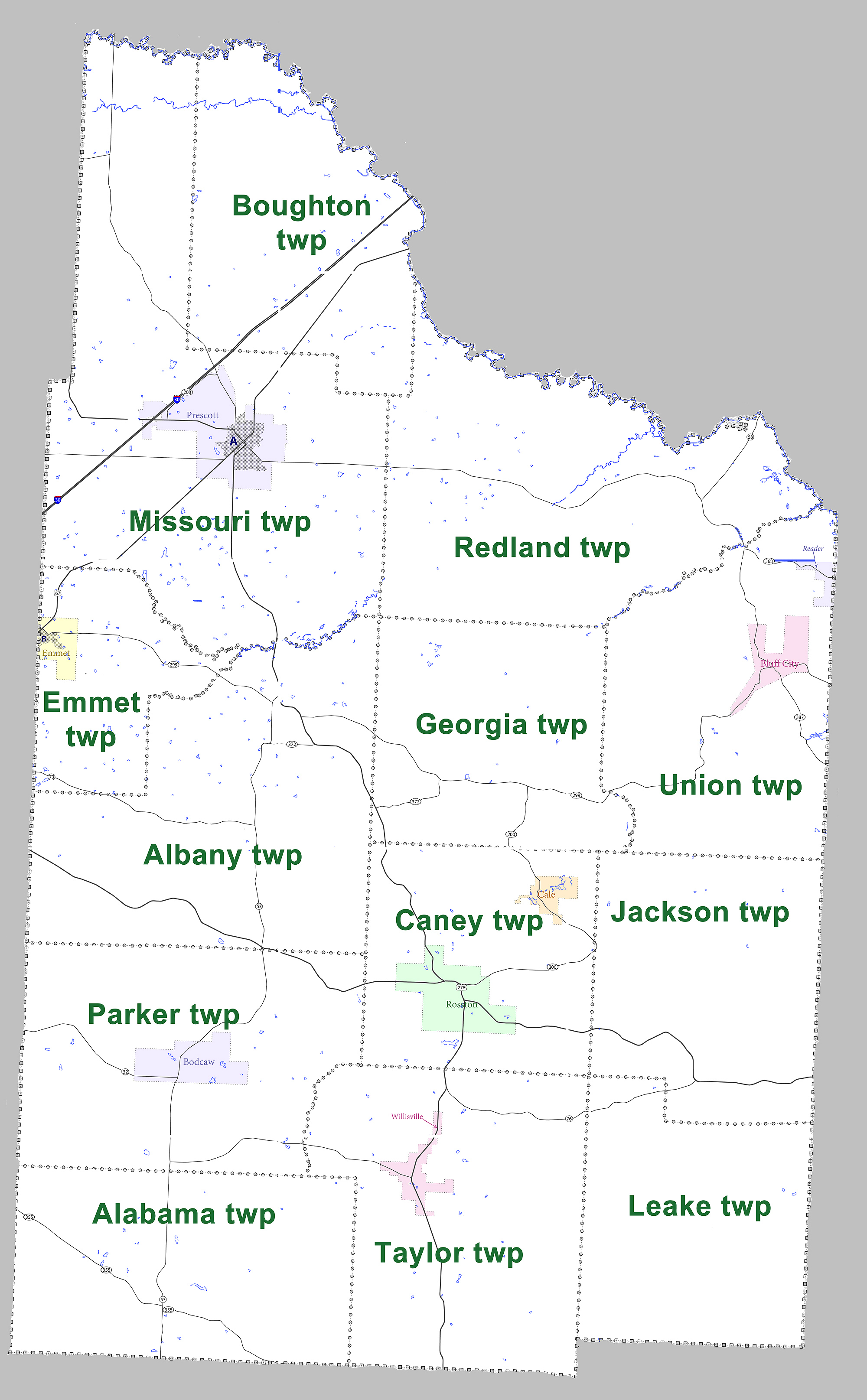
Nevada County is a county located in the southwestern part of the U.S. state of Arkansas. As of the 2010 census, the population was 8,997, less than half of its peak in 1920. The county seat is Prescott. Nevada County is Arkansas's 63rd county, formed during the Reconstruction era on March 20, 1871, from portions of Hempstead, Ouachita and Columbia counties. It was named after the state of Nevada because of the perceived similarity between their physical shapes; the Arkansas county's shape, inverted, roughly follows the same outline as the state's boundary. It is an alcohol prohibition or dry county. Dorcheat Bayou, a 122-mile stream, begins in Nevada County. It flows south into Columbia County and across the border into Webster Parish, Louisiana, where it flows into Lake Bistineau and ultimately Loggy Bayou, forming a continuous passage to the Red River. In the 19th century, the bayou was navigable for three to six months by steamboat from Bistineau to Minden. The wate ... [...More Info...] [...Related Items...] OR: [Wikipedia] [Google] [Baidu] |
Arkansas Counties
There are 75 counties in the U.S. state of Arkansas. Arkansas is tied with Mississippi for the most counties with two county seats, at 10. __TOC__ Counties Former counties in Arkansas Lovely County Created on October 13, 1827, partitioned from Crawford County. The Treaty of Washington, 1828 ceded most of its territory to Indian Territory. Abolished October 17, 1828 with the remaining portion becoming Washington County. Miller County Created from Hempstead County. Most of its northern portion was in Choctaw Nation (now part of Oklahoma); rest of northern portion was dissolved into Sevier County in 1828. All of its southern portion was in Texas, and was nominally dissolved into Lafayette County in 1838. Notes References External links State of Arkansas local government resources search {{Arkansas Arkansas, counties in Counties A county is a geographic region of a country used ... [...More Info...] [...Related Items...] OR: [Wikipedia] [Google] [Baidu] |
Caddo
The Caddo people comprise the Caddo Nation of Oklahoma, a federally recognized tribe headquartered in Binger, Oklahoma. They speak the Caddo language. The Caddo Confederacy was a network of Indigenous peoples of the Southeastern Woodlands, who historically inhabited much of what is now East Texas, west Louisiana, southwestern Arkansas, and southeastern Oklahoma. Prior to European contact, they were the Caddoan Mississippian culture, who constructed huge earthwork mounds at several sites in this territory, flourishing about 800 to 1400 CE. In the early 19th century, Caddo people were forced to a reservation in Texas. In 1859, they were removed to Indian Territory. Government and civic institutions The Caddo Nation of Oklahoma was previously known as the Caddo Tribe of Oklahoma. The tribal constitution provides for election of an eight-person council, with a chairperson. Some 6,000 people are enrolled in the nation, with 3,044 living within the state of Oklahoma. [...More Info...] [...Related Items...] OR: [Wikipedia] [Google] [Baidu] |
Arkansas 32
Highway 32 (AR 32, Ark. 32, and Hwy. 32) is a designation for three state highways in South Arkansas. One route of runs from Oklahoma State Highway 3 (SH-3) at the Oklahoma state line east to Highway 355 at Saratoga. A second route of begins near Hope Municipal Airport and runs through Oakhaven to Highway 29. A third segment of begins at US 278 and runs east to US 371 in Willisville. __TOC__ Route description AR 32 runs east from Oklahoma and meets AR 41 in Foreman. After angling south, AR 32 meets US 59/US 71 in Ashdown and AR 355 in Saratoga. The route then winds through the country before meeting US 278 near the Hope Municipal Airport. Continuing east, AR 32 crosses Interstate 30 and runs with US 278 BUS until exiting town headed southeast. The route meets AR 53 in Bodclaw and US 371/ AR 19 in Willisville, where the route terminates. Major intersections Mile markers reset at concurrencies. Ashdown business ro ... [...More Info...] [...Related Items...] OR: [Wikipedia] [Google] [Baidu] |
Highway 24 (Arkansas)
Arkansas Highway 24 is the designation of two separate state highways in southwest and south central Arkansas. The two sections were formerly connected, but a middle segment of between Lockesburg and Prescott was redesignated as U.S. Route 371 (US 371) in 1994. Section 1 Arkansas Highway 24 is a state highway of in Sevier County."Sevier County, Arkansas." Arkansas State Highway and Transportation DepartmentAHTD Sevier County mapRetrieved on July 25, 2010. It runs from Oklahoma east to US 71 in Lockesburg. Route description The route begins at the Oklahoma state line as CR E2100 in McCurtain County, Oklahoma and runs east to Horatio. AR 24 has a short concurrency with AR 41 in Horatio, but continues east alone. The route is the southern terminus of AR 329 (a former alignment of US 71) before terminating at US 71 in Lockesburg. Major intersections Section 2 Arkansas Highway 24 is a state highway of in Nevada and Ouachita Counties."Nevada County, Arkansas." Arkan ... [...More Info...] [...Related Items...] OR: [Wikipedia] [Google] [Baidu] |
Highway 19 (Arkansas)
Arkansas Highway 19 (AR 19 and Hwy. 19) is a designation for two state highway in South Arkansas. The first route of runs from Louisiana Highway 159 (LA 159) north to U.S. Route 79B (US 79B) in Magnolia. A second segment runs north from US Route 371/Arkansas Highway 24 (US 371/AR 24) across Interstate 30 (I-30) to Narrows Dam at Lake Greeson. Route description Louisiana to Magnolia The route begins at the Louisiana state line at Louisiana Highway 159 and runs north to serve as the western terminus for Highway 98 at Walkerville and later the eastern terminus of Highway 160 at Macedonia. The route continues northeast into Magnolia, where the route terminates at US Route 79B. Prescott to Lake Greeson Highway 19 begins in Prescott at US 371/ AR 24 in the northwest corner of town and runs northwest to meet Highway 200, which is a frontage road for Interstate 30. After the I-30 interchange, Highway 19 continues ... [...More Info...] [...Related Items...] OR: [Wikipedia] [Google] [Baidu] |
US 371
U.S. Route 371 is a north–south United States highway in the U.S. states of Arkansas and Louisiana. The highway's northern terminus is in De Queen, Arkansas at an intersection with U.S. Highway 70. It is co-signed for its last between Lockesburg, Arkansas and DeQueen with U.S. Highway 59 and U.S. Highway 71. Its southern terminus is west of Coushatta, Louisiana at an intersection with Interstate 49. Route description Louisiana U.S. 371 is an afterthought in the federal highway system. Within Louisiana it was merely the 1990s renumbering and re-signing of the post-1955 Louisiana Highway 7 north of US 71, which after the 1990s change ceased to exist as a number for a state highway in Louisiana. The section south of US 71 was the post-1955 Louisiana Highway 179, which after the 1990s change ceased to exist as a number for a state highway in Louisiana. It also replaced a section of Louisiana Highway 177. Although signage is on I-49, US 371 begins just north of Coushat ... [...More Info...] [...Related Items...] OR: [Wikipedia] [Google] [Baidu] |
US 278
U.S. Route 278 (US 278) is a parallel route of US 78. It currently runs for from Hilton Head Island, South Carolina, to Wickes, Arkansas at US 71/ US 59, passing through five states in the process. Landmarks along its route include the Department of Energy's Savannah River Site in South Carolina and the Tennessee-Tombigbee Waterway in eastern Mississippi. There are several universities located along the highway including Georgia State University, the University of Mississippi, and the University of Arkansas at Monticello. Route description Arkansas US 278 begins at an intersection with US 59/ US 71 in the town of Wickes in southwestern Arkansas. From Wickes, US 278 continues eastward near Gillham Lake to an overlap with US 70 through Dierks. Continuing south, US 278 overlaps Highway 26 for at Center Point. Further south the route continues into Nashville. The route overlaps US 371 and later Highway 27 upon entering Nas ... [...More Info...] [...Related Items...] OR: [Wikipedia] [Google] [Baidu] |
US 67
U.S. Route 67 is a major north–south U.S. highway which extends for 1,560 miles (2,511 km) in the Central United States. The southern terminus of the route is at the United States-Mexico border in Presidio, Texas, where it continues south as Mexican Federal Highway 16 upon crossing the Rio Grande. The northern terminus is at U.S. Route 52 in Sabula, Iowa. US 67 crosses the Mississippi River twice along its routing. The first crossing is at West Alton, Missouri, where US 67 uses the Clark Bridge to reach Alton, Illinois. About to the north, US 67 crosses the river again at the Rock Island Centennial Bridge between Rock Island, Illinois, and Davenport, Iowa. Additionally, the route crosses the Missouri River via the Lewis Bridge a few miles southwest of the Clark Bridge. Route description , - , TX , 766 , 1233 , - , AR , 325 , 523 , - , MO , 201 , 323 , - , IL , 212 , 341 , - , IA , 56 , 90 , - , Total , 1560 , 2511 Texas Throughout Texas, US 67 runs ... [...More Info...] [...Related Items...] OR: [Wikipedia] [Google] [Baidu] |
Interstate 30
Interstate 30 (I-30) is a Interstate Highway in the southern states of Texas and Arkansas in the United States. I-30 travels from I-20 west of Fort Worth, Texas, northeast via Dallas, and Texarkana, Texas, to I-40 in North Little Rock, Arkansas. The highway parallels U.S. Highway 67 (US 67) except for the portion west of downtown Dallas (which was once part of I-20). Between the termini, I-30 has interchanges with I-35W, I-35E, and I-45. I-30 is known as the Tom Landry Freeway between I-35W and I-35E, within the core of the Dallas–Fort Worth metroplex. Route description , - , Texas , , , - , Arkansas , , , - , Total , , I-30 is the shortest two-digit Interstate with a number ending in zero in the Interstate System. The Interstates ending in zero are generally the longest east–west Interstates. The largest metropolitan areas that I-30 travels through include the Dallas–Fort Worth metroplex, the Texarkana metropolitan area, and the Little Rock met ... [...More Info...] [...Related Items...] OR: [Wikipedia] [Google] [Baidu] |
I-30 (AR)
Interstate 30 (I-30) is a Interstate Highway in the southern states of Texas and Arkansas in the United States. I-30 travels from I-20 west of Fort Worth, Texas, northeast via Dallas, and Texarkana, Texas, to I-40 in North Little Rock, Arkansas. The highway parallels U.S. Highway 67 (US 67) except for the portion west of downtown Dallas (which was once part of I-20). Between the termini, I-30 has interchanges with I-35W, I-35E, and I-45. I-30 is known as the Tom Landry Freeway between I-35W and I-35E, within the core of the Dallas–Fort Worth metroplex. Route description , - , Texas , , , - , Arkansas , , , - , Total , , I-30 is the shortest two-digit Interstate with a number ending in zero in the Interstate System. The Interstates ending in zero are generally the longest east–west Interstates. The largest metropolitan areas that I-30 travels through include the Dallas–Fort Worth metroplex, the Texarkana metropolitan area, and the Little Rock metropolita ... [...More Info...] [...Related Items...] OR: [Wikipedia] [Google] [Baidu] |


