|
Mewari
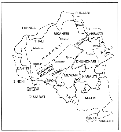
Mewari is an Indo-Aryan language of the Rajasthani languages group. It is spoken by about five million speakers in Rajsamand, Bhilwara, Udaipur, Chittorgarh and Pratapgarh districts of Rajasthan state and Mandsaur, Neemuch districts of Madhya Pradesh state of India. There are 31 consonants, 10 vowels and 2 diphthongs in Mewari. Intonation is prominent. Dental fricative is replaced by glottal stop at initial and medial positions. Inflection and derivation are the forms of word formation. There are two numbers—singular and plural, two genders—masculine and feminine, and three cases—simple, oblique, and vocative. Case marking is partly inflectional and partly postpositional. Concord is of nominative type in the imperfective aspect but ergative in the perfective aspect. Nouns are declined according to their endings. Pronouns are inflected for number, person, and gender. Third person is distinguished not only in gender but also in remote-proximal level. There are three ... [...More Info...] [...Related Items...] OR: [Wikipedia] [Google] [Baidu] |
Marwari Language
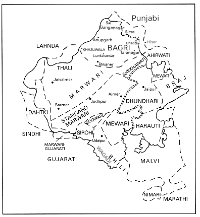
Marwari (, , ) is a Western Indo-Aryan languages, Western Indo-Aryan language belonging to the Indo-Iranian languages, Indo-Iranian subdivision of the Indo-European languages. Marwari and its closely related varieties like Dhundhari language, Dhundhari, Shekhawati language, Shekhawati and Mewari language, Mewari form a part of the broader Rajasthani language family. It is spoken in the Indian state of Rajasthan, as well as the neighbouring states of Gujarat and Haryana, some adjacent areas in eastern parts of Pakistan, and some migrant communities in Nepal. There are two dozen varieties of Marwari. Marwari is popularly written in Devanagari script, as are many languages of India and Nepal, including Hindi, Marathi language, Marathi, Nepali language, Nepali, and Sanskrit; although it was historically written in Mahajani, it is still written in the Perso-Arabic script by the Marwari minority in Eastern parts of Pakistan (the standard/western Naskh (script), Naskh script variant ... [...More Info...] [...Related Items...] OR: [Wikipedia] [Google] [Baidu] |
Rajasthani Dialects
The Rajasthani languages are a group of Western Indo-Aryan languages, primarily spoken in Rajasthan and Malwa, and adjacent areas of Haryana, Gujarat and Madhya Pradesh in India and South Punjab and the adjacent areas of Sindh in Pakistan. They have also reached different corners of India, especially eastern and southern parts of India, due to the migrations of people of the Marwari community who use them for internal communication. Rajasthani languages are also spoken to a lesser extent in Nepal, where they are spoken by 25,394 people according to the 2011 Census of Nepal. The term Rajasthani is also used to refer to a literary language mostly based on Marwari.. Geographical distribution Most of the Rajasthani languages are chiefly spoken in the state of Rajasthan but are also spoken in Gujarat, Western Madhya Pradesh i.e. Malwa and Nimar, Haryana and Punjab. Rajasthani languages are also spoken in the Bahawalpur and Multan sectors of the Pakistani provinces of Punjab and Th ... [...More Info...] [...Related Items...] OR: [Wikipedia] [Google] [Baidu] |
Rajasthani Languages
The Rajasthani languages are a group of Western Indo-Aryan languages, primarily spoken in Rajasthan and Malwa, and adjacent areas of Haryana, Gujarat and Madhya Pradesh in India and South Punjab and the adjacent areas of Sindh in Pakistan. They have also reached different corners of India, especially eastern and southern parts of India, due to the migrations of people of the Marwari community who use them for internal communication. Rajasthani languages are also spoken to a lesser extent in Nepal, where they are spoken by 25,394 people according to the 2011 Census of Nepal. The term Rajasthani is also used to refer to a literary language mostly based on Marwari.. Geographical distribution Most of the Rajasthani languages are chiefly spoken in the state of Rajasthan but are also spoken in Gujarat, Western Madhya Pradesh i.e. Malwa and Nimar, Haryana and Punjab. Rajasthani languages are also spoken in the Bahawalpur and Multan sectors of the Pakistani provinces of Pu ... [...More Info...] [...Related Items...] OR: [Wikipedia] [Google] [Baidu] |
Udaipur District
Udaipur district is one of the 50 districts of Rajasthan state in western India. The historic city of Udaipur is the administrative headquarters of the district. The district is part of the Mewar region of Rajasthan. History Before Udaipur district was established in independent India, it was a part of former Mewar or Udaipur State, comprising little less than half the portion of the former state. With the formation of the United State of Rajasthan in 1948, parts of the erstwhile district of Girwa, Khamnor, Rajnagar, Bhim, Magra, Kherwara and Kumbhalgarh, together with the thikanas of Nathdwara, Kankroli, Salumbar (excluding Sayra tehsil), Bhinder, Kanor, Bansi, Bari Sadri, Amet, Sardargarh, Deogarh and Gogunda were combined to constitute the district of Udaipur. During the decadal period 1951–61, two new tehsils – Nathdwara and Gogunda – were created in the district. In 1991, seven tehsils of Udaipur district (Bhim, Deogarh, Amet, Kumbhalgarh, Rajsamand, Nathdwara ... [...More Info...] [...Related Items...] OR: [Wikipedia] [Google] [Baidu] |
Rajsamand District
Rajsamand District is a district of the state of Rajasthan in western India. The city of Rajsamand is the district headquarters. The district was constituted on 10 April 1991 from Udaipur district by carving out 7 tehsils - Bhim, Deogarh, Amet, Kumbhalgarh, Rajsamand, Nathdwara, and Railmagra. Geography The district has an area of 4,768 km2. The Aravalli Range forms the northwestern boundary of the district, across which lies Pali District. Beawar District lies to the north, Bhilwara District to the northeast and east, Chittorgarh District to the southeast, and Udaipur District to the south. The district lies in the watershed of the Banas River and its tributaries. Some other rivers are: Ari, Gomati, Chandrabhaga Demographics According to the 2011 census Rajsamand district has a population of 1,156,597, roughly equal to the nation of Timor-Leste or the US state of Rhode Island. This gives it a ranking of 405th in India (out of a total of 640). The distri ... [...More Info...] [...Related Items...] OR: [Wikipedia] [Google] [Baidu] |
Indo-Aryan Languages
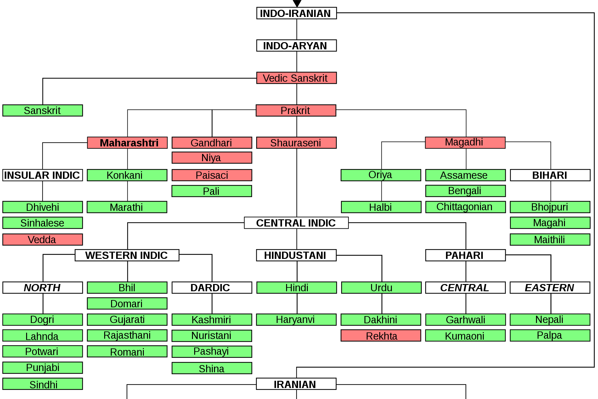
The Indo-Aryan languages, or sometimes Indic languages, are a branch of the Indo-Iranian languages in the Indo-European languages, Indo-European language family. As of 2024, there are more than 1.5 billion speakers, primarily concentrated east of the Indus river in Bangladesh, Northern India, Eastern Pakistan, Sri Lanka, Maldives and Nepal. Moreover, apart from the Indian subcontinent, large immigrant and expatriate Indo-Aryan–speaking communities live in Northwestern Europe, Western Asia, North America, the Caribbean, Southeast Africa, Polynesia and Australia, along with several million speakers of Romani languages primarily concentrated in Southeast Europe, Southeastern Europe. There are over 200 known Indo-Aryan languages. Modern Indo-Aryan languages descend from Old Indo-Aryan languages such as early Vedic Sanskrit, through Middle Indo-Aryan languages (or Prakrits). The largest such languages in terms of First language, first-speakers are Hindustani language, Hindi–Urdu ... [...More Info...] [...Related Items...] OR: [Wikipedia] [Google] [Baidu] |
Western Indo-Aryan Languages
The Indo-Aryan languages, or sometimes Indic languages, are a branch of the Indo-Iranian languages in the Indo-European language family. As of 2024, there are more than 1.5 billion speakers, primarily concentrated east of the Indus river in Bangladesh, Northern India, Eastern Pakistan, Sri Lanka, Maldives and Nepal. Moreover, apart from the Indian subcontinent, large immigrant and expatriate Indo-Aryan–speaking communities live in Northwestern Europe, Western Asia, North America, the Caribbean, Southeast Africa, Polynesia and Australia, along with several million speakers of Romani languages primarily concentrated in Southeastern Europe. There are over 200 known Indo-Aryan languages. Modern Indo-Aryan languages descend from Old Indo-Aryan languages such as early Vedic Sanskrit, through Middle Indo-Aryan languages (or Prakrits). The largest such languages in terms of first-speakers are Hindi–Urdu (),Standard Hindi first language: 260.3 million (2001), as second language: 1 ... [...More Info...] [...Related Items...] OR: [Wikipedia] [Google] [Baidu] |
Neemuch District
Neemuch district () is one of the 55 districts of Madhya Pradesh state in central India. The town of Neemuch is the administrative headquarters of the district. Asia's largest solar power plant, inaugurated by Narendra Modi, as BJP's prime ministerial candidate Welspun Solar MP project operating since February, 2014 at Neemuch. It is a 151 megawatt) photovoltaic power station constructed at a cost of 1100 crore rupees (about $182,000,000) on 305 hectares (750 acres) of land. Neemuch district is part of Ujjain Division and had 726,070 inhabitants as of 2001, rising to 826,067 as of 2011. Neemuch district is bordered by Rajasthan state on the west and north, and by Mandsaur district to the east and south. History This district was created on 30 June 1998 by separating Neemuch, Manasa and Jawad tehsils of the erstwhile Mandsaur district. During the British rule, the district headquarters Neemuch was a cantonment town, known as the North India Mounted Artillery and Cavalry Headqua ... [...More Info...] [...Related Items...] OR: [Wikipedia] [Google] [Baidu] |
Mandsaur District
Mandsaur district () is a district of Madhya Pradesh state in central India. The town of Mandsaur is the administrative headquarters of the district. The ancient Pashupatinath temple is situated in Mandsaur. Large quantities of opium are produced in Mandsaur district. Origin of name The District takes its name from the headquarters town, Mandsaur. It is considered to have been evolved from Marhsaur, originating from Marh and Saur or Dasaur, two of the villages which merged in the town. The town was known as Dashpur during ancient times. Other etymology claims it derives from Mandodari, wife of Ravana, who is said to have been born in the district. Geography The district has an area of . The district is present on the border of the Mewar and Malwa so the culture is the combination of the both regions, and is bounded by Neemuch District to the north west, Chittorgarh district to North east, Kota district and Jhalawar district to east and Pratapgarh District, and Ratlam Dist ... [...More Info...] [...Related Items...] OR: [Wikipedia] [Google] [Baidu] |
Bhilwara District
Bhilwara District is a district of the States and territories of India, state of Rajasthan in western India. The city of Bhilwara is the district headquarters. History Stone Age tools dating from 5,000 to 200,000 years were found in Bundi district, Bundi and Bhilwara districts of the state. Geography The district has an area of 10,455 km², and a population of 2,408,523 (2011 census), which increased 19.60% from 2001 to 2011. Famous for its textile & minerals Industries. It is bounded on the north by Ajmer District, on the east by Bundi District, on the south by Chittorgarh District and on the west by Rajsamand District. State Highway (Jaipur-Udaipur) passes through the district, as does a broad gauge railway line measuring 84 km and connecting Ajmer with Khandwa in Madhya Pradesh. The nearest airport is at Udaipur, Rajasthan, Udaipur (171 km). Administration There are 7 sub-divisions in the district: Bhilwara, Shahpura, Bhilwara, Shahpura, Gangapur, Bhilwara, ... [...More Info...] [...Related Items...] OR: [Wikipedia] [Google] [Baidu] |
Rajasthan
Rajasthan (; Literal translation, lit. 'Land of Kings') is a States and union territories of India, state in northwestern India. It covers or 10.4 per cent of India's total geographical area. It is the List of states and union territories of India by area, largest Indian state by area and the List of states and union territories of India by population, seventh largest by population. It is on India's northwestern side, where it comprises most of the wide and inhospitable Thar Desert (also known as the Great Indian Desert) and shares a border with the Pakistani provinces of Punjab, Pakistan, Punjab to the northwest and Sindh to the west, along the Sutlej-Indus River valley. It is bordered by five other Indian states: Punjab, India, Punjab to the north; Haryana and Uttar Pradesh to the northeast; Madhya Pradesh to the southeast; and Gujarat to the southwest. Its geographical location is 23°3' to 30°12' North latitude and 69°30' to 78°17' East longitude, with the Tropic of Can ... [...More Info...] [...Related Items...] OR: [Wikipedia] [Google] [Baidu] |
Mewar
Mewar, also spelled as Mewad is a region in the south-central part of Rajasthan state of India. It includes the present-day districts of Bhilwara, Chittorgarh, Pratapgarh, Rajsamand, Udaipur, Pirawa Tehsil of Jhalawar District of Rajasthan, Neemuch and Mandsaur of Madhya Pradesh and some parts of Gujarat. For centuries, the region was ruled by Rajputs as Kingdom of Mewar. During the period of British East India Company, it became a princely state as Udaipur. It emerged as an administrative unit during the period governance in India and remained until the end of the British Raj era. The Mewar region lies between the Aravali Range to the northwest, Ajmer to the north, Gujarat and the Vagad region of Rajasthan to the south, the Malwa region of Madhya Pradesh state to the south and the Hadoti region of Rajasthan to the east. Etymology The word "Mewar" is vernacular form of "Medapata" (IAST: Medapāṭa), the ancient name of the region. The earliest epigraph that ment ... [...More Info...] [...Related Items...] OR: [Wikipedia] [Google] [Baidu] |


