|
Ländchen (Havelland)
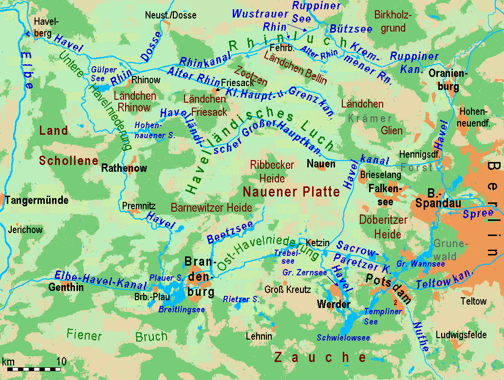
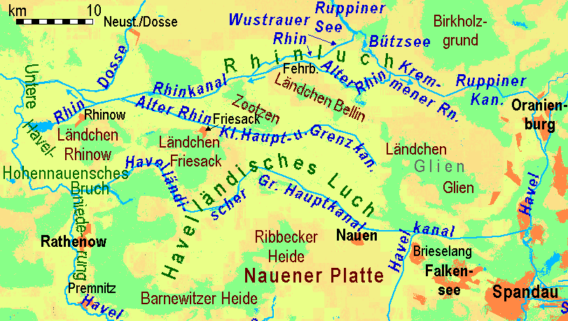
A ''Ländchen'' (literally "little land" or "little country") is the German name given to several Ice Age plateaux in the Havelland region, which climb to over 70 metres above the formerly marshy ''urstromtal'' levels (old glacial meltwater valleys) of the Havelland Luch and the Rhinluch. The difference between these ''Ländchen'' and the surrounding countryside is even more marked because of the different land uses to which they are put. Extensive pastures in the lowlands contrast with the arable fields and woods on the low hills. Geologically they are largely complete formations of ground moraine from the Saale and Weichselian glaciations that, in places, are covered by gently rolling end moraines. Their names are: * Ländchen Bellin near Fehrbellin * Ländchen Friesack near Friesack * Ländchen Glien near Paaren im Glien north of Falkensee * Ländchen Rhinow near Rhinow near the confluence of the Rhin and the Havel * Land Schollene between Havel and the Elbe valley ... [...More Info...] [...Related Items...] OR: [Wikipedia] [Google] [Baidu] |
Havelland FHSW
Geographically, the Havelland () is the region around which the River Havel flows in a U-shape between Oranienburg to the northeast and Rhinow to the northwest. The northern boundary of the Havelland is formed by the River Rhin and the Rhin Canal. In the history of Brandenburg, the Havelland represents a historic region. In the heart of the Havelland is the Landkreis Havelland, county of the same name. In addition the Havelland includes the south of Ruppin Land with the Rhinluch, the western part of Berlin's Spandau, parts of Potsdam, the town of Brandenburg an der Havel and several villages in the county of Potsdam-Mittelmark. The Tourist Association of Havelland has chosen a rather different boundary. It covers the county of Havelland, the town of Brandenburg an der Havel and the northern part of the county of Potsdam-Mittelmark, including communities south of the Havel river, that belong to the region of Zauche. The writer Theodor Fontane described the Havelland as well as t ... [...More Info...] [...Related Items...] OR: [Wikipedia] [Google] [Baidu] |
Schönwalde-Glien
Schönwalde-Glien is a municipality in the Havelland district, in Brandenburg, Germany. History The municipality shared its borders with the former West Berlin, and so during the period 1961-1990 it was separated from it by the Berlin Wall. In 1951–2, the Havel Canal was constructed through the municipality to link Hennigsdorf with Paretz, thus avoiding a passage through the reach of the River Havel, between Spandau and Potsdam, that was under the political control of West Berlin. The single lock on the canal is located at Schönwalde. The canal is still in use, providing a shorter route for shipping from west of Berlin to the Oder–Havel Canal and Poland. Geography The municipality covers an area mainly north of the Havel Canal, north west of Spandau Forest (Berlin-Spandau) and about 10 km north east of Nauen. Only its most densely populated quarter, Schönwalde-Siedlung, is situated south of the Havel Canal and shares an immediate border with Berlin-Spandau. Sch� ... [...More Info...] [...Related Items...] OR: [Wikipedia] [Google] [Baidu] |
Geography Of Brandenburg
Geography (from Ancient Greek ; combining 'Earth' and 'write', literally 'Earth writing') is the study of the lands, features, inhabitants, and phenomena of Earth. Geography is an all-encompassing discipline that seeks an understanding of Earth and its human and natural complexities—not merely where objects are, but also how they have changed and come to be. While geography is specific to Earth, many concepts can be applied more broadly to other celestial bodies in the field of planetary science. Geography has been called "a bridge between natural science and social science disciplines." Origins of many of the concepts in geography can be traced to Greek Eratosthenes of Cyrene, who may have coined the term "geographia" (). The first recorded use of the word γεωγραφία was as the title of a book by Greek scholar Claudius Ptolemy (100 – 170 AD). This work created the so-called "Ptolemaic tradition" of geography, which included "Ptolemaic cartographic theory." ... [...More Info...] [...Related Items...] OR: [Wikipedia] [Google] [Baidu] |
Luche
The term ''Luch'' (plural: ''Luche'') is German and refers to an area of originally expansive, marshy or boggy lowland in northeast Germany, especially in the state of Brandenburg. ''Luche'' are found mainly in Young Drift regions; but they also occur on Old Drift landscapes. According to Leser the term should not be translated. Location and history ''Luche'' mainly formed in the main urstromtal valleys or their side valleys. After the end of the Ice Age, the water table rose during the postglacial period resulting in the formation of bogs. The peat thickness is not particularly great; in most cases it is less than 2 metres thick. Before the installation of artificial drainage networks excess water often accumulated in the ''Luche'' in ponds. In contrast with lowlands with natural watercourses, they were give a different name from the neighbouring ''Bruche'' ( carrs), such as the Oderbruch to the east and the Hohennauen Bruch on the Havel to the west. Most of the ''Luche'' in ... [...More Info...] [...Related Items...] OR: [Wikipedia] [Google] [Baidu] |
Nauen Plateau
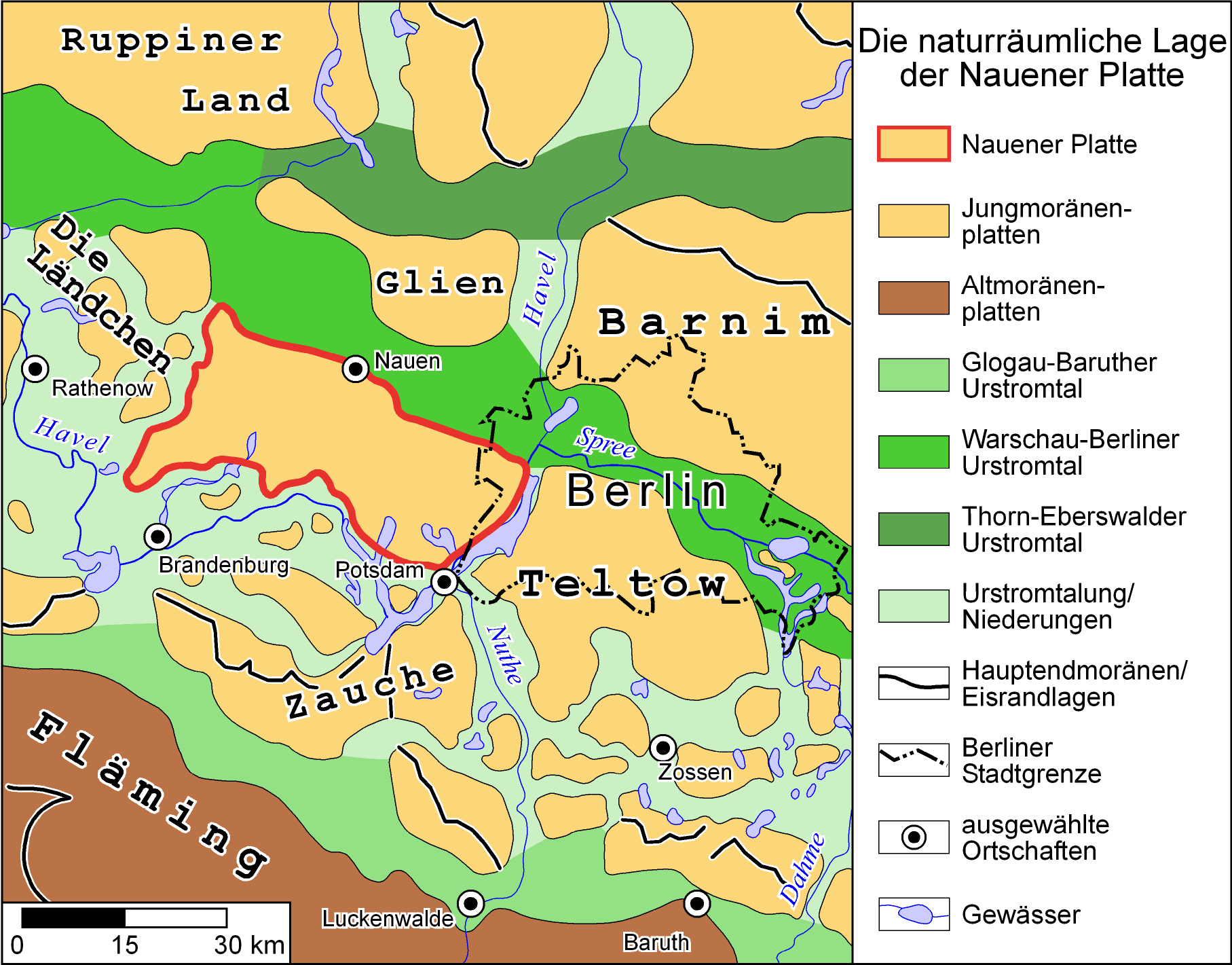
The Nauen Plateau () is a low plateau in the German states of Brandenburg and Berlin. It rises above the surrounding countryside by an average of and is a largely contiguous upland area that was formed during the Saale glaciation, Saale and Weichselian glaciations. It consists predominantly of ground moraine deposits, partly overlain by gently rolling end moraine formations. Whilst the neighbouring regions of Zauche to the south, the Teltow (region), Teltow to the southeast and the Barnim to the northeast have the same name as their geological formation, the cultural landscape on the Nauen Plateau bears the historical and regional name of Havelland. That said, the river country of the Havelland extends beyond the plateau to include the Havel valley and other lowland areas. Location The Nauen Plateau lies in the Margraviate of Brandenburg, central Mark and in the extreme west of the state of Berlin. Its northern boundary is formed by a glacial meltwater valley, the Berlin Urstrom ... [...More Info...] [...Related Items...] OR: [Wikipedia] [Google] [Baidu] |
Ribbeck Heath
Ribbeck is a German surname. Notable people with the surname include: *Erich Ribbeck Erich Ribbeck (born 13 June 1937) is a German former professional football player and manager, best known for coaching in the Bundesliga. In 1988, he won the UEFA Cup as manager of Bayer Leverkusen, the first title in the club's history. Playin ... (born 1937), German football player and manager * Otto Ribbeck (1827–1898), German classical scholar * Katharina Ribbeck, German-American biologist See also * '' Herr von Ribbeck auf Ribbeck im Havelland'', German poem * Ribbeck (Meteorite) {{surname, Ribbeck German-language surnames ... [...More Info...] [...Related Items...] OR: [Wikipedia] [Google] [Baidu] |
Rathenow
Rathenow () is a town in the district of Havelland (district), Havelland in Brandenburg, in eastern Germany, with a population of 24,063 (2020). Overview The Protestant church of St. Marien Andreas, originally a basilica, and transformed to the Gothic style in 1517-1589, and the Roman Catholic Church of St. George, are noteworthy. Rathenow is known for being the former capital of eyewear manufacturing in German Democratic Republic, East Germany. It is also known for its stones, called Rathenow stones. History In 1675, during the Scanian War, it was the site of a Battle of Rathenow, battle between Swedish and Brandenburgian forces. During World War II, Rathenow was the location of a Forced labour under German rule during World War II, forced labour subcamp of the Nazi prison for women and juveniles in Lichtenberg, Berlin, Berlin-Lichtenberg and a subcamp of the Sachsenhausen concentration camp. Prisoners of the latter were mostly Dutch, Belgian and French. Demographics File:Bev� ... [...More Info...] [...Related Items...] OR: [Wikipedia] [Google] [Baidu] |
Land Schollene
Land, also known as dry land, ground, or earth, is the solid terrestrial surface of Earth not submerged by the ocean or another body of water. It makes up 29.2% of Earth's surface and includes all continents and islands. Earth's land surface is almost entirely covered by regolith, a layer of rock, soil, and minerals that forms the outer part of the crust. Land plays an important role in Earth's climate system, being involved in the carbon cycle, nitrogen cycle, and water cycle. One-third of land is covered in trees, another third is used for agriculture, and one-tenth is covered in permanent snow and glaciers. The remainder consists of desert, savannah, and prairie. Land terrain varies greatly, consisting of mountains, deserts, plains, plateaus, glaciers, and other landforms. In physical geology, the land is divided into two major categories: Mountain ranges and relatively flat interiors called cratons. Both form over millions of years through plate tectonics. Streams – a ... [...More Info...] [...Related Items...] OR: [Wikipedia] [Google] [Baidu] |
Havel
The Havel () is a river in northeastern Germany, flowing through the States of Germany, states of Mecklenburg-Vorpommern, Brandenburg, Berlin and Saxony-Anhalt. The long Havel is a right tributary of the Elbe. However, the direct distance from its source to its mouth is only . For much of its length, the Havel is navigable; it provides an important link in the waterway connections between the east and west of Germany, as well as beyond. Source The source of the Havel is located in the Mecklenburg Lake District, between Lake Müritz and the city of Neubrandenburg. There is no obvious visible source in the form of a spring, but the river originates in the lakes in the Diekenbruch near Ankershagen, close to and south-east of the Drainage divide, watershed between the North and Baltic seas. From there the river initially flows southward, eventually joining the Elbe, which in turn flows into the North Sea. Every river north-east of it flows to the Baltic Sea. The river enters Brande ... [...More Info...] [...Related Items...] OR: [Wikipedia] [Google] [Baidu] |
Rhin
The Rhin is a long river in Brandenburg, Germany, right tributary to the river Havel. It flows through the city Neuruppin and several lakes. A few kilometres downstream from Rhinow it flows into the Havel, about upstream from where the Havel meets the Elbe The Elbe ( ; ; or ''Elv''; Upper Sorbian, Upper and , ) is one of the major rivers of Central Europe. It rises in the Giant Mountains of the northern Czech Republic before traversing much of Bohemia (western half of the Czech Republic), then Ge .... File:Zermuetzel_bridge_Rhin.jpg, In Neuruppin-Zermützel File:Wustrau_Wustrauer_Rhin.jpg, Wustrauer Rhin in Fehrbellin-Wustrau File:Fehrbellin_Wustrauer_Rhin.jpg, Wustrauer Rhin in Fehrbellin File:Fehrbellin_Wall_bridge.jpg, Bützrhin near Fehrbellin-Wall References Rivers of Brandenburg Rivers of Germany {{Brandenburg-river-stub ... [...More Info...] [...Related Items...] OR: [Wikipedia] [Google] [Baidu] |
Rhinow
Rhinow () is a town in the Havelland (district), Havelland district (Landkreis), in Brandenburg, Germany. It is situated 16 km north of Rathenow, and 22 km south of Kyritz. Rhinow is the administrative seat (Verwaltungssitz) of the Rhinow (Amt), Rhinow district (Amt). Geography The region lies on the southern edge of the Rhinluch (Rhin moor) and at the feet of the up to 110 Meter high Rhinower Mountains. The Rhin river flows west through the district into the Gülper See at the southwestern border. Bundesstraße, Federal highway (Bundesstraße) 102 cuts through the area. Since 2003, the stretch between Rathenow and Neustadt (Dosse) is no longer served by public rail transit (Öffentlichen Personennahverkehr). Administrative division Greater Rhinow includes the village of Kietz. History During the Third Reich, a famous sail plane school was founded in memory of Otto Lilienthal. Demography Politics City Council The council of the city of Rhinow has 12 me ... [...More Info...] [...Related Items...] OR: [Wikipedia] [Google] [Baidu] |


