|
List Of Cities, Towns And Villages In Vojvodina
This is a list of cities, towns and villages in Vojvodina, a province of Serbia , image_flag = Flag of Serbia.svg , national_motto = , image_coat = Coat of arms of Serbia.svg , national_anthem = () , image_map = , map_caption = Location of Serbia (gree .... List of largest cities and towns in Vojvodina List of urban settlements in Vojvodina List of all urban settlements (cities and towns) in Vojvodina with population figures from recent censuses: South Bačka District: West Bačka District: North Bačka District: North Banat District: Central Banat District: South Banat District: Syrmia District: The inhabited places of South Bačka District City of Novi Sad – Novi Sad Municipality Hamlets and suburbs: * Bangladeš (Бангладеш) * Kamenjar (Камењар) * Lipov Gaj (Липов Гај) * Nemanovci (Немановци) * Pejićevi Salaši (Пејићеви ... [...More Info...] [...Related Items...] OR: [Wikipedia] [Google] [Baidu] [Amazon] |
Vojvodina Map02
Vojvodina ( ; sr-Cyrl, Војводина, ), officially the Autonomous Province of Vojvodina, is an autonomous province that occupies the northernmost part of Serbia, located in Central Europe. It lies within the Pannonian Basin, bordered to the south by the national capital Belgrade and the Sava and Danube Rivers. The administrative centre, Novi Sad, is the second-largest city in Serbia. The historic regions of Banat, Bačka, Syrmia and northernmost part of Mačva overlap the province. Modern Vojvodina is multi-ethnic and multi-cultural, with some 26 ethnic groups and six official languages. Fewer than two million people, nearly 27% of Serbia's population, live in the province. Name ''Vojvodina'' is also the Serbian word for voivodeship, a type of duchy overseen by a voivode. The Serbian Voivodeship, a precursor to modern Vojvodina, was an Austrian province from 1849 to 1860. Its official name is the Autonomous Province of Vojvodina. Its name in the province's six offic ... [...More Info...] [...Related Items...] OR: [Wikipedia] [Google] [Baidu] [Amazon] |
Sombor
Sombor ( sr-Cyrl, Сомбор, ; ; ) is a List of cities in Serbia, city and the administrative center of the West Bačka District in the autonomous province of Vojvodina, Serbia. The city has a total population of 41,814 (), while its administrative area (including neighboring villages) has 70,818 inhabitants. Name and etymology In Serbian language, Serbian, the city is known as ''Sombor'' (Сомбор), in Hungarian language, Hungarian as ''Zombor'', in Pannonian Rusyn language, Rusyn as ''Zombor'' (Зомбор). The older Hungarian name for the city was ''Czoborszentmihály''. The name originates from the Czobor family, who were the owners of this area in the 14th century. (The family name came from the Slavic name ''Cibor''.) The Serbian language, Serbian name for the city ''(Sombor)'' also came from the family name Czobor, and was first recorded in 1543, although the city was mentioned in historical documents under several more names, such as ''Samobor, Sambor, Sambir, ... [...More Info...] [...Related Items...] OR: [Wikipedia] [Google] [Baidu] [Amazon] |
Bačka Palanka
Bačka Palanka ( sr-cyrl, Бачка Паланка, ; ) is a town and municipality located in the South Bačka District of the autonomous province of Vojvodina, Serbia. It is situated on the left bank of the Danube. In 2022 the town had a total population of 25,476, while Bačka Palanka municipality had 48,265 inhabitants. Name In Serbian language, Serbian, the town is known as Бачка Паланка or ''Bačka Palanka'', in Slovak language, Slovak as ''Báčska Palanka'', in Croatian language, Croatian as ''Bačka Palanka'', in Hungarian language, Hungarian as ''Bácspalánka'', in German language, German as ''Plankenburg'' and in Turkish language, Turkish as ''Küçük Hisar''. Its name means "a town in Bačka" in Serbian language, Serbian. The word "Palanka (fortification), palanka" itself originates from Turkish language. This word was also adopted by Serbs and it is used in the Serbian language with the same meaning. Older Serbian names for this town were Palanka (П ... [...More Info...] [...Related Items...] OR: [Wikipedia] [Google] [Baidu] [Amazon] |
Downtown Ruma
''Downtown'' is a term primarily used in American and Canadian English to refer to a city's sometimes commercial, cultural and often the historical, political, and geographic heart. It is often synonymous with its central business district (CBD). It may also be a center for shopping and entertainment. Downtowns typically contain a small percentage of a city's employment but are concentrated in services, including high-end services (office or white-collar jobs). Sometimes, smaller downtowns include lower population densities and nearby lower incomes than suburbs. It is often distinguished as a hub of public transit and culture. History Origins The ''Oxford English Dictionarys first citation for "down town" or "downtown" dates to 1770, in reference to the center of Boston. Some have posited that the term "downtown" was coined in New York City, where it was in use by the 1830s to refer to the original settlement, or town, at the southern tip of the island of Manhattan.Fogelson, ... [...More Info...] [...Related Items...] OR: [Wikipedia] [Google] [Baidu] [Amazon] |
Ruma
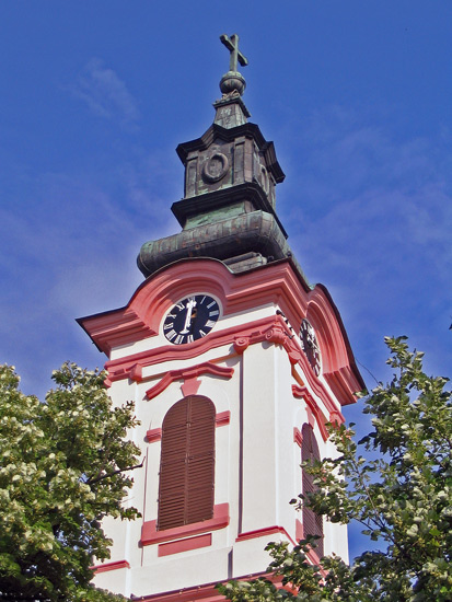
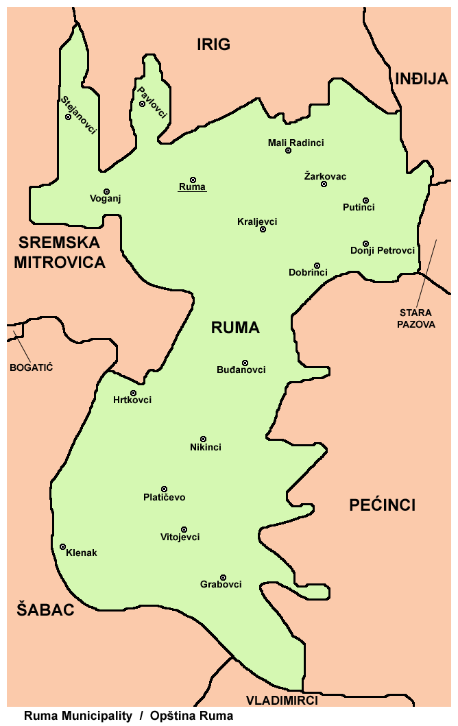
Ruma (; ) is a town and municipality in the Srem District of the Autonomous Province of Vojvodina, Serbia. As of 2022, the town has a population of 27,747, while the municipality has a population of 48,621. History Traces of organized human life on the territory of Ruma municipality date back as far as prehistory. The most important archaeological locality in the municipality is Bronze Age Gomolava near Hrtkovci, with two exclusive tombs of Bosut culture dating to the 9th century BC and 3000BC Vučedol culture pottery. The first known inhabitants of this area were various peoples of Illyrians, Illyrian and Celts, Celtic origin, such as the Amantini, Breuci, Scordisci, etc. During the Roman Empire, Roman rule, local inhabitants lost their ethnic character and adopted Roman culture. There were no larger Roman settlements on the territory of Ruma, but a certain number of agricultural estates known as "Roman villa, villae rusticae" were located there. Migrations of Huns, Germanic peo ... [...More Info...] [...Related Items...] OR: [Wikipedia] [Google] [Baidu] [Amazon] |
Vršac
Vršac ( sr-Cyrl, Вршац, ) is a city in the autonomous province of Vojvodina, Serbia. As of 2022, the city urban area had a population of 31,946, while the city administrative area had 45,462 inhabitants. It is located in the geographical region of Banat. Etymology The name ''Vršac'' is of Serbian origin, ultimately deriving from Proto-Slavic *vьrxъ, meaning "summit". In Serbian, the city is known as Вршац or ''Vršac'', in Romanian as ''Vârșeț'' or Vîrșeț, in Hungarian as ''Versec'' or ''Versecz'', in German as ''Werschetz'', and in Turkish as ''Virşac'' or ''Verşe''. History The uniqueness of Vršac is reflected in the fact that it has been inhabited since the dawn of the first cultures. Thus, the oldest traces of human presence in Banat originate precisely from Vršac, since individual finds of Paleolithic flint tools from the middle and younger Paleolithic, Mousterian and Aurignacian cultures were found on the slopes of the Vršac Mountains. Th ... [...More Info...] [...Related Items...] OR: [Wikipedia] [Google] [Baidu] [Amazon] |
The View To New Orthodox Church And Neighborhood
''The'' is a grammatical article in English, denoting nouns that are already or about to be mentioned, under discussion, implied or otherwise presumed familiar to listeners, readers, or speakers. It is the definite article in English. ''The'' is the most frequently used word in the English language; studies and analyses of texts have found it to account for seven percent of all printed English-language words. It is derived from gendered articles in Old English which combined in Middle English and now has a single form used with nouns of any gender. The word can be used with both singular and plural nouns, and with a noun that starts with any letter. This is different from many other languages, which have different forms of the definite article for different genders or numbers. Pronunciation In most dialects, "the" is pronounced as (with the voiced dental fricative followed by a schwa) when followed by a consonant sound, and as (homophone of the archaic pronoun ''thee' ... [...More Info...] [...Related Items...] OR: [Wikipedia] [Google] [Baidu] [Amazon] |
Syrmia District
The Srem District (, ) is one of administrative districts of Serbia. It lies in the geographical regions of Syrmia and Mačva. According to the 2022 census, the Srem District has a population of 282,547 inhabitants. The administrative center is the city of Sremska Mitrovica. Cities and municipalities The Srem District encompasses the territories of one city and six municipalities: * Sremska Mitrovica (city) * Inđija (municipality) * Irig (municipality) * Pećinci (municipality) * Ruma (municipality) * Stara Pazova (municipality) * Šid (municipality) History In Late antiquity, between the 3rd and 5th centuries, the city of Sirmium (present-day Sremska Mitrovica) was a capital of the Roman province of Pannonia Secunda. In the 6th century Sirmium was the capital of Byzantine Pannonia. In the 7th century, during Avar administration, the area was ruled by Bulgar local ruler Kuber, while in the 11th century, it was ruled by independent Bulgarian- Slavic duke Sermon. In the ... [...More Info...] [...Related Items...] OR: [Wikipedia] [Google] [Baidu] [Amazon] |
Sremska Mitrovica
Sremska Mitrovica (; sr-Cyrl, Сремска Митровица, ) is a List of cities in Serbia, city in Serbia. It is situated on the left bank of the Sava, Sava river. , the city has a total population of 36,764 inhabitants, while its administrative area has a population of 72,580 inhabitants. As Sirmium, it was a capital of the Roman Empire during the Tetrarchy of 4th century CE. Ten Roman emperors were born in or near this city, Emperors Herennius Etruscus (251), Hostilian (251), Decius, Decius Traian (249–251), Claudius Gothicus (268–270), Quintillus (270), Aurelian (270–275), Marcus Aurelius Probus, Probus (276–282), Maximian (285–310), Constantius II (337–361) and Gratian (367–383). Name The modern town name is ''Sremska Mitrovica'' (). The Hungarian language, Hungarian name was ''Szávaszentdemeter'' while in Croatian language, Croatian it is referred to as ''Srijemska Mitrovica''. In Pannonian Rusyn, it is referred to as . Mitrovica stems from Saint Deme ... [...More Info...] [...Related Items...] OR: [Wikipedia] [Google] [Baidu] [Amazon] |
Kikinda2
Kikinda ( sr-Cyrl, Кикинда, ; ) is a city and the administrative center of the North Banat District in Serbia. The city's urban area has 32,084 inhabitants, while the city administrative area has 49,326 inhabitants. The city was founded in the 18th century. From 1774 to 1874 Kikinda was the seat of the District of Velika Kikinda, an autonomous administrative unit of Habsburg monarchy. In 1893, Kikinda was granted the status of a city. The city became part of the Kingdom of Serbia (and Kingdom of Serbs, Croats and Slovenes) in 1918, and it lost the city status. The status was re-granted in 2016. In 1996, the well-preserved archaeological remnants of a half a million-year-old mammoth were excavated on the outer edge of the town area. The mammoth called "Kika" has become one of the symbols of the town. Today it is exhibited in the National Museum of Kikinda. Other attractions of the city are the Suvača – a unique horse-powered dry mill, the annual Pumpkin Days and t ... [...More Info...] [...Related Items...] OR: [Wikipedia] [Google] [Baidu] [Amazon] |
North Banat District
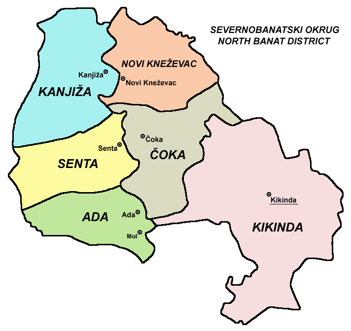
The North Banat District (, ) is one of administrative districts of Serbia. It lies in the geographical regions of Banat and Bačka. According to the 2022 census, the North Banat District has a population of 117,896 inhabitants. The administrative center of the district is the city of Kikinda. History In the 9th century, the area was ruled by the Bulgarian- Slavic dukes Glad (in the east) and Salan (in the west), while in the 11th century, the eastern part of the area was ruled by duke Ahtum. From the 11th to the 16th century, during the administration of the medieval Kingdom of Hungary, the area was divided between the Csanadiensis County, Temesiensis County and Torontaliensis County in the east, and the Csongradiensis County, Bacsensis County and Bodrogiensis County in the west. Part of the area was also located within the Cumania region. From 1526 to 1527, the area was ruled by the independent Serb ruler, emperor Jovan Nenad, while during Ottoman administration ... [...More Info...] [...Related Items...] OR: [Wikipedia] [Google] [Baidu] [Amazon] |


