|
Lewis Chapel, Tennessee
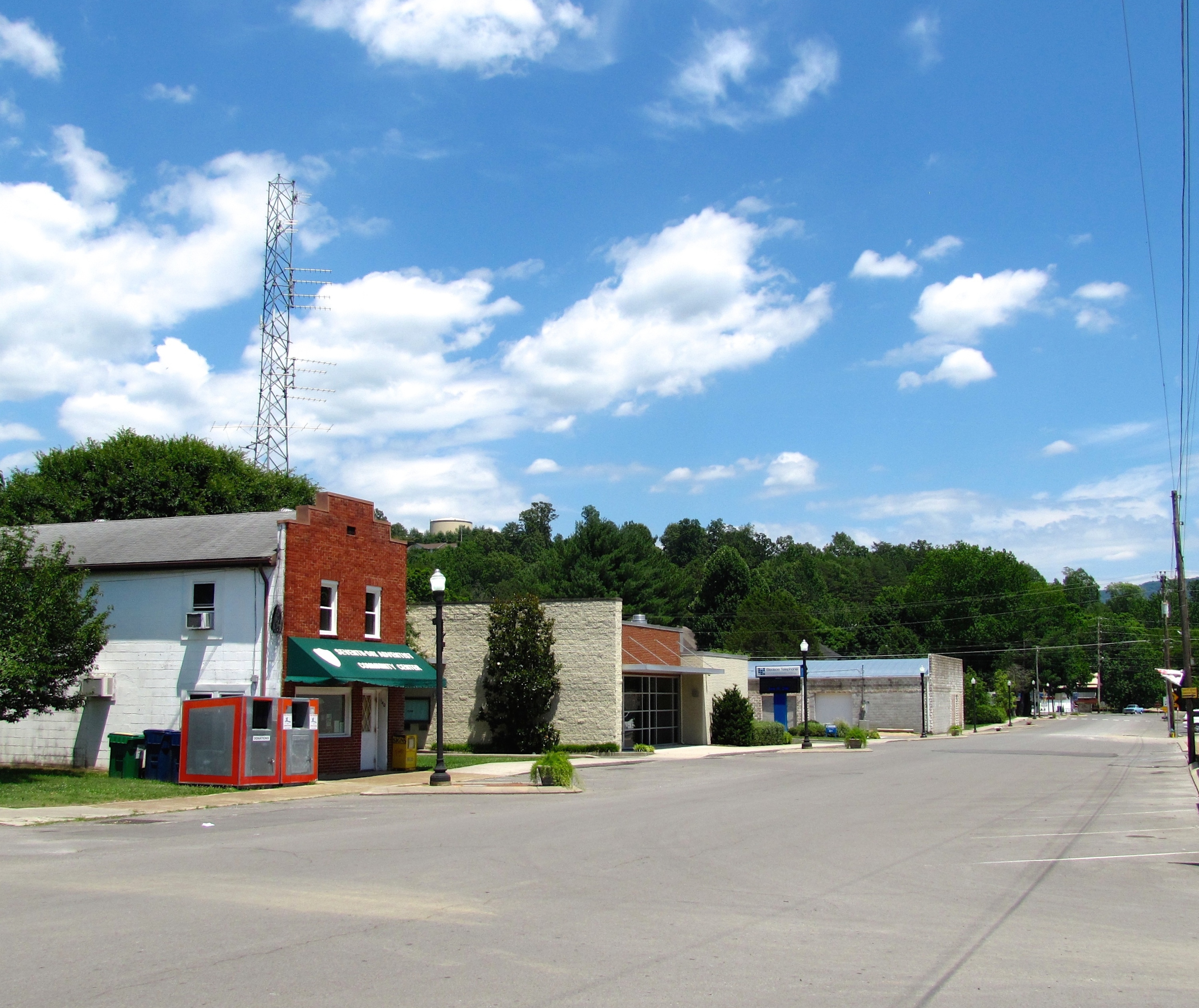
Lewis Chapel is an unincorporated community in Sequatchie County, Tennessee, United States. It is located in the eastern part of the county atop the Cumberland Plateau. Tennessee State Route 111 connects the community to Dunlap in the Sequatchie Valley to the west and Soddy-Daisy and the outskirts of Chattanooga Chattanooga ( ) is a city in and the county seat of Hamilton County, Tennessee, United States. Located along the Tennessee River bordering Georgia, it also extends into Marion County on its western end. With a population of 181,099 in 2020, ... in the Tennessee Valley to the east. Lewis Chapel was probably named for the Reverend Edgar R. Lewis, an early minister in the area.Larry Miller, Tennessee Place Names' (Indiana University Press, 2001), p. 122. References Unincorporated communities in Sequatchie County, Tennessee Unincorporated communities in Tennessee {{SequatchieCountyTN-geo-stub ... [...More Info...] [...Related Items...] OR: [Wikipedia] [Google] [Baidu] |
Unincorporated Community
An unincorporated area is a region that is not governed by a local municipal corporation. Widespread unincorporated communities and areas are a distinguishing feature of the United States and Canada. Most other countries of the world either have no unincorporated areas at all or these are very rare: typically remote, outlying, sparsely populated or uninhabited areas. By country Argentina In Argentina, the provinces of Chubut, Córdoba, Entre Ríos, Formosa, Neuquén, Río Negro, San Luis, Santa Cruz, Santiago del Estero, Tierra del Fuego, and Tucumán have areas that are outside any municipality or commune. Australia Unlike many other countries, Australia has only one level of local government immediately beneath state and territorial governments. A local government area (LGA) often contains several towns and even entire metropolitan areas. Thus, aside from very sparsely populated areas and a few other special cases, almost all of Australia is part of an LGA. Uninco ... [...More Info...] [...Related Items...] OR: [Wikipedia] [Google] [Baidu] |
Unincorporated Area
An unincorporated area is a region that is not governed by a local municipal corporation. Widespread unincorporated communities and areas are a distinguishing feature of the United States and Canada. Most other countries of the world either have no unincorporated areas at all or these are very rare: typically remote, outlying, sparsely populated or List of uninhabited regions, uninhabited areas. By country Argentina In Argentina, the provinces of Chubut Province, Chubut, Córdoba Province (Argentina), Córdoba, Entre Ríos Province, Entre Ríos, Formosa Province, Formosa, Neuquén Province, Neuquén, Río Negro Province, Río Negro, San Luis Province, San Luis, Santa Cruz Province, Argentina, Santa Cruz, Santiago del Estero Province, Santiago del Estero, Tierra del Fuego Province, Argentina, Tierra del Fuego, and Tucumán Province, Tucumán have areas that are outside any municipality or commune. Australia Unlike many other countries, Australia has only local government in Aus ... [...More Info...] [...Related Items...] OR: [Wikipedia] [Google] [Baidu] |
Chattanooga, Tennessee
Chattanooga ( ) is a city in and the county seat of Hamilton County, Tennessee, United States. Located along the Tennessee River bordering Georgia (U.S. state), Georgia, it also extends into Marion County, Tennessee, Marion County on its western end. With a population of 181,099 in 2020, it is Tennessee's fourth-largest city and one of the two principal cities of East Tennessee, along with Knoxville, Tennessee, Knoxville. It anchors the Chattanooga metropolitan area, Tennessee's fourth-largest metropolitan statistical area, as well as a larger three-state area that includes Southeast Tennessee, Northwest Georgia, and Northeast Alabama. Chattanooga was a crucial city during the American Civil War, due to the multiple railroads that converge there. After the war, the railroads allowed for the city to grow into one of the Southeastern United States' largest heavy industrial hubs. Today, major industry that drives the economy includes automotive, advanced manufacturing, food and ... [...More Info...] [...Related Items...] OR: [Wikipedia] [Google] [Baidu] |
Soddy-Daisy, Tennessee
Soddy-Daisy is a city in Hamilton County, Tennessee, United States. The population was 13,070 at the 2020 census and estimated to be 13,619 in 2022. The city was formed in 1969 when the communities of Soddy (to the north) and Daisy (to the south), along with nearby developed areas along U.S. Highway 27, merged to form Soddy-Daisy. It is becoming a bedroom community of nearby Chattanooga and is part of the Chattanooga Metropolitan Statistical Area. Sequoyah Nuclear Generating Station is located in Soddy-Daisy. History Soddy-Daisy is an incorporated city, comprising the former Tennessee cities of Soddy and Daisy. It has frequently been noted on lists of unusual place names. Soddy-Daisy was home to Hamilton County's first courthouse and government seat, Poe's Tavern. The tavern, built in 1819, was the home of Soddy-Daisy resident Hasten Poe. In 1838, the tavern served as a way station for 1,900 Cherokees who were on the Trail of Tears. During the Civil War, Poe's Tavern served as ... [...More Info...] [...Related Items...] OR: [Wikipedia] [Google] [Baidu] |
Sequatchie Valley
Sequatchie Valley is a relatively long and narrow valley in the U.S. state of Tennessee and, in some definitions, Alabama. It is generally considered to be part of the Cumberland Plateau region of the Appalachian Mountains; it was probably formed by erosion of a compression anticline, rather than rifting process as had been formerly theorized. The Sequatchie River drains the valley in Tennessee, flowing south to southwest from the southern part of Cumberland County, Tennessee to the Tennessee River near the Alabama border. Geologically, the Sequatchie Valley continues south of the Tennessee River into central Alabama. The Tennessee River flows through the Alabama portion of the valley to the vicinity of Guntersville, Alabama. The valley continues south of Guntersville, where it is called Browns Valley, drained by Browns Creek (Thornbury 1965:148). Although this whole valley is geologically the same, the name Sequatchie is commonly used only for the Tennessee portion of the va ... [...More Info...] [...Related Items...] OR: [Wikipedia] [Google] [Baidu] |
Dunlap, Tennessee
Dunlap is a city in and the county seat of Sequatchie County, Tennessee, United States. The population was 5,357 at the 2020 census and 4,815 at the 2010 census. Dunlap is part of the Chattanooga, TN– GA Metropolitan Statistical Area. History Dunlap was founded in 1858 as a county seat for Sequatchie County, which had been created the previous year. The city was named for state legislator William Claiborne Dunlap, who played a prominent role in the county's creation. The city's initial , which were deeded to the county commissioners by Willam Rankin, were chosen due to their central location within the new county. Dunlap was incorporated as a city in 1941. Around 1900, the Douglas Coal and Coke Company purchased of land in the Dunlap vicinity with plans to mine coal and convert the coal into industrial coke. Coke, which is created by heating coal and removing its volatile matter, is used primarily as a deoxidizing agent in the production of pig iron. To convert co ... [...More Info...] [...Related Items...] OR: [Wikipedia] [Google] [Baidu] |
Tennessee State Route 111
State Route 111 (SR 111) is a north–south highway in Middle and East Tennessee. The road begins in Soddy-Daisy and ends north of Byrdstown in the community of Static, at the Tennessee/Kentucky state line. The length is . Route description The highway begins at an interchange with U.S. Route 27/ SR 29 (US 27/SR 29) in Soddy-Daisy. SR 111 travels generally northwest as a controlled access highway before it crosses into Sequatchie County. The controlled-access sections of SR 111 are unusual, as they contain 70 mph speed limits, which are generally reserved for Interstate highways. It then proceeds over Walden Ridge and into the Sequatchie Valley, where it comes to an interchange with US 127 and starts a concurrency with SR 8 in Dunlap, where the freeway ends. The concurrency goes up the Cumberland Plateau, continuing as a 4-lane road, albeit without a dividing median or wide shoulders, and into the northern part of the county where ... [...More Info...] [...Related Items...] OR: [Wikipedia] [Google] [Baidu] |
Cumberland Plateau
The Cumberland Plateau is the southern part of the Appalachian Plateau in the Appalachian Mountains of the United States. It includes much of eastern Kentucky and Tennessee, and portions of northern Alabama and northwest Georgia. The terms " Allegheny Plateau" and the "Cumberland Plateau" both refer to the dissected plateau lands lying west of the main Appalachian Mountains. The terms stem from historical usage rather than geological difference, so there is no strict dividing line between the two. Two major rivers share the names of the plateaus, with the Allegheny River rising in the Allegheny Plateau and the Cumberland River rising in the Cumberland Plateau in Harlan County, Kentucky. Geography The Cumberland Plateau is a deeply dissected plateau, with topographic relief commonly of about , and frequent sandstone outcroppings and bluffs. At Kentucky's Pottsville Escarpment, which is the transition from the Cumberland Plateau to the Bluegrass in the north and the Pennyri ... [...More Info...] [...Related Items...] OR: [Wikipedia] [Google] [Baidu] |
Geographic Names Information System
The Geographic Names Information System (GNIS) is a database of name and locative information about more than two million physical and cultural features throughout the United States and its territories, Antarctica, and the associated states of the Marshall Islands, Federated States of Micronesia, and Palau. It is a type of gazetteer. It was developed by the United States Geological Survey (USGS) in cooperation with the United States Board on Geographic Names (BGN) to promote the standardization of feature names. Data were collected in two phases. Although a third phase was considered, which would have handled name changes where local usages differed from maps, it was never begun. The database is part of a system that includes topographic map names and bibliographic references. The names of books and historic maps that confirm the feature or place name are cited. Variant names, alternatives to official federal names for a feature, are also recorded. Each feature receives ... [...More Info...] [...Related Items...] OR: [Wikipedia] [Google] [Baidu] |
List Of Sovereign States
The following is a list providing an overview of sovereign states around the world with information on their status and recognition of their sovereignty. The 206 listed states can be divided into three categories based on membership within the United Nations System: 193 member states of the United Nations, UN member states, 2 United Nations General Assembly observers#Present non-member observers, UN General Assembly non-member observer states, and 11 other states. The ''sovereignty dispute'' column indicates states having undisputed sovereignty (188 states, of which there are 187 UN member states and 1 UN General Assembly non-member observer state), states having disputed sovereignty (16 states, of which there are 6 UN member states, 1 UN General Assembly non-member observer state, and 9 de facto states), and states having a political status of the Cook Islands and Niue, special political status (2 states, both in associated state, free association with New Zealand). Compi ... [...More Info...] [...Related Items...] OR: [Wikipedia] [Google] [Baidu] |
Area Code 423
Area code 423 is a telephone area code in the North American Numbering Plan for the U.S. state of Tennessee. It comprises two disconnected areas of East Tennessee that are separated by area code 865. Principal cities in the northern part of the area code region are Morristown, Greeneville, Kingsport, Johnson City, and Bristol (more commonly known as the Tri-Cities region). The principal cities in the south are Chattanooga and Cleveland. History When the North American Numbering Plan was created in 1947, Tennessee was a single numbering plan area (NPA) with area code 901. In 1954, 901 was reduced to West Tennessee, while the eastern part of the state received area code 615. In 1995, the eastern portion of 615, including Knoxville, Chattanooga, and the Tri-Cities, was split off as area code 423. This was the first new area code in the state in 41 years. The boundary between 423 and 615 roughly followed the line between the Eastern and Central time zones; generally, Tennesse ... [...More Info...] [...Related Items...] OR: [Wikipedia] [Google] [Baidu] |


