|
Laâyoune-Sakia El Hamra
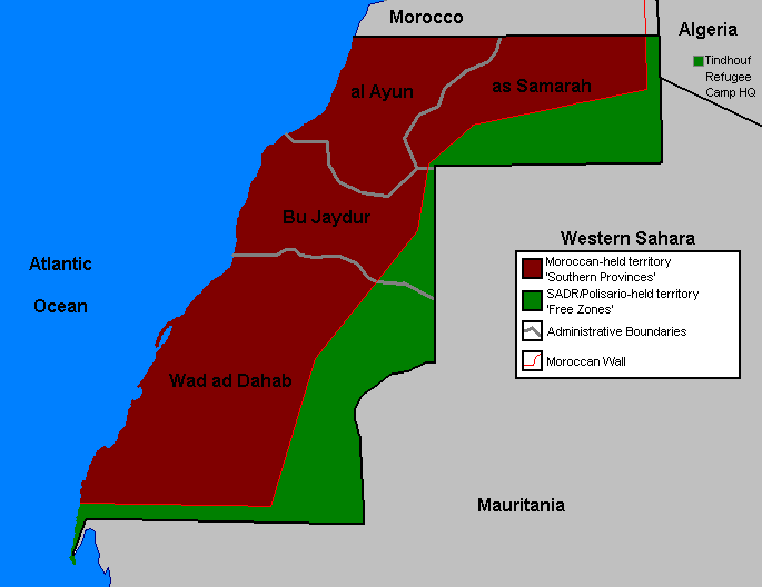
Laâyoune-Sakia El Hamra () is one of the twelve regions of Morocco. It is mainly located in the disputed territory of Western Sahara: the western part of the region is administered by Morocco and the eastern part by the Sahrawi Arab Democratic Republic. The region as claimed by Morocco covers an area of and had a population of 367,758 as of the 2014 Moroccan census. The capital of the region is Laâyoune. Geography Laâyoune-Sakia El Hamra borders the region of Guelmim-Oued Noun to the north and Dakhla-Oued Ed-Dahab to the south. It shares its eastern border with Mauritania's Tiris Zemmour Region, and to its west is the Atlantic Ocean. The towns of Tarfaya, El Marsa and Boujdour are located on the Atlantic coast, and the Canary Islands are located offshore. The regional capital Laâyoune is located inland near El Marsa, and the region's second-largest town Smara is located near its geographic centre. The Moroccan Wall runs through the region and the area to its east is ... [...More Info...] [...Related Items...] OR: [Wikipedia] [Google] [Baidu] |
Regions Of Morocco
Regions are currently the highest administrative divisions in Morocco. Since 2015, Morocco officially administers 12 regions, including one (Dakhla-Oued Ed-Dahab) that lies completely within the disputed territory of Western Sahara and two (Laâyoune-Sakia El Hamra and Guelmim-Oued Noun) that lie partially within it. The regions are subdivided into a total of 75 second-level administrative divisions, which are Prefectures and provinces of Morocco, prefectures and provinces. A region is governed by a directly elections in Morocco, elected regional council. The president of the council is responsible for carrying out the council's decisions. Prior to the 2011 Moroccan constitutional referendum, 2011 constitutional reforms, this was the responsibility of the Wali (administrative title), Wali, the representative of the central government appointed by the King, who now plays a supporting role in the administration of the region. Regions since 2015 On 3 January 2010, the Moroccan g ... [...More Info...] [...Related Items...] OR: [Wikipedia] [Google] [Baidu] |
Istiqlal Party
The Istiqlal Party (; ; ) is a political party in Morocco. It is a conservative and monarchist party and a member of the Centrist Democrat International and International Democracy Union. Istiqlal headed a coalition government under Abbas El Fassi from 19 September 2007 to 29 November 2011. From 2013 to 2021, it was part of the opposition. Since 2021 it is part of a coalition government led by Aziz Akhannouch. The party emerged in the year 1937 during the anti-colonial struggle against French and Spanish imperial rule, making it the oldest active political party in Morocco. History and profile The party was founded in April 1937 as the National Party for Istiqlal, and became the Istiqlal Party 10 December 1943. Istiqlal held strongly Arab nationalist views and was the main political force struggling for the independence of Morocco. The initial goal stated in their manifesto was the independence from France “within the framework of a constitutional-democratic monarchy”. Th ... [...More Info...] [...Related Items...] OR: [Wikipedia] [Google] [Baidu] |
La Nouvelle Tribune
''La Nouvelle Tribune'' is a weekly francophone Moroccan newspaper. History and profile ''La Nouvelle Tribune'' was established in 1995 by Fahd Yata. He is also the owner and director of the paper. The publisher is Impression Presse Edition. The paper is published weekly on Thursdays. As of 2016, its total circulation averages 9,010 copies with individual purchase numbers averaging 4,014 copies. See also * List of newspapers in Morocco Newspapers in Morocco are primarily published in Arabic language, Arabic and French language, French, and to a lesser extent in Berber languages, Berber, English language, English, and Spanish language, Spanish. ''Africa Liberal'', a Spanish langu ... References External links * {{DEFAULTSORT:Nouvelle Tribune 1994 establishments in Morocco French-language newspapers published in Morocco Newspapers published in Morocco Newspapers established in 1994 Socialist newspapers Weekly newspapers Mass media in Casablanca ... [...More Info...] [...Related Items...] OR: [Wikipedia] [Google] [Baidu] |
Polisario Front
The Popular Front for the Liberation of Saguia el-Hamra and Río de Oro (Spanish language, Spanish: ; ), better known by its acronym Polisario Front, is a Sahrawi nationalism, Sahrawi nationalist liberation movement seeking to end the occupation of Western Sahara through the means of self-determination and Wars of national liberation, armed resistance. Tracing its origin to a Sahrawi nationalist organization known as the Movement for the Liberation of Saguia el Hamra and Wadi el Dhahab, the Polisario Front was formally constituted in 1973 with the intention of launching an armed struggle against the Spanish Sahara, Spanish occupation which lasted until 1975, when the Spanish decided to allow Mauritania and Morocco to partition and occupy the territory. The Polisario Front proclaimed the Sahrawi Arab Democratic Republic (SADR) on 27 February 1976, and Western Sahara War, waged a war to drive out the two armies. It forced Mauritania to relinquish its claim over Western Sahara in ... [...More Info...] [...Related Items...] OR: [Wikipedia] [Google] [Baidu] |
Laâyoune-Boujdour-Sakia El Hamra
Laâyoune-Boujdour-Sakia El Hamra () was one of the sixteen regions of Morocco from 1997 to 2015. It was mainly located in the disputed territory of Western Sahara, covered an area of and had a population of 301,744 as of the 2004 census. Its capital was Laayoune. In September 2015, the region was combined with Es-Semara Province in Guelmim-Es Semara to form the new region of Laâyoune-Sakia El Hamra. Geography The region was bordered to the east by the region of Guelmim-Es Semara. To the south was the region of Oued Ed-Dahab-Lagouira, entirely within the Western Sahara. The east of the region bordered the Mauritanian region of Tiris Zemmour. Laâyoune-Boujdour-Sakia El Hamra had a coastline on the Atlantic Ocean, facing the Spanish Canary Islands. The region consisted of the following provinces: * Boujdour Province * Laâyoune Province * Tarfaya Province Municipalities by population (2004 census) The capital Laayoune contained 73% of the region's population. Of the four m ... [...More Info...] [...Related Items...] OR: [Wikipedia] [Google] [Baidu] |
Guelmim-Es Semara
Guelmim-Es Semara () was one of the sixteen former regions of Morocco from 1997 to 2015. It covered an area of and had a population of 501,921 (2014 census). The regional capital was Guelmim. Geography The southern half of Guelmin-Es Semara formed part of the Western Sahara. The region was bordered to the north by Souss-Massa-Drâa and to the west by Laayoune-Boujdour-Sakia El Hamra, with the Algerian province of Tindouf to the east. Its disputed territory in the Western Sahara bordered the Mauritanian Tiris Zemmour Region. Guelmin-Es Semara had a coastline on the Atlantic Ocean, with the Spanish Canary Islands lying off it. The Draa River, at 1,100 km the longest in Morocco, flowed through the region into the Atlantic Ocean near Tan-Tan. The region was made up of the following provinces: * Assa-Zag Province * Es Smara Province * Guelmim Province * Tan-Tan Province * Tata Province Municipalities by population (2004 census) Source: * Guelmin, Guelmim Province: 95,599 * ... [...More Info...] [...Related Items...] OR: [Wikipedia] [Google] [Baidu] |
Es Semara Province
Es Semara () is a province in the Moroccan economic region of Laâyoune-Sakia El Hamra, and the disputed territory of Western Sahara Western Sahara is a territorial dispute, disputed territory in Maghreb, North-western Africa. It has a surface area of . Approximately 30% of the territory () is controlled by the Sahrawi Arab Democratic Republic (SADR); the remaining 70% is .... Its population in 2004 was 60,426. Its major town is Es Semara. Subdivisions The province is divided administratively into the following: References Es Semara Province {{LaâyouneSakiaElHamra-geo-stub ... [...More Info...] [...Related Items...] OR: [Wikipedia] [Google] [Baidu] |
Moroccan Western Sahara Wall
The Moroccan Western Sahara Wall or the Berm, also called the Moroccan sand wall (), is an approximately berm running south to north through Western Sahara and the southwestern portion of Morocco. It separates the Moroccan-controlled areas (the Southern Provinces) on the west from the Polisario-controlled areas ( Free Zone, nominally Sahrawi Arab Democratic Republic) on the east. The main function of the barriers is to exclude guerrilla fighters of the Polisario Front, who have sought Western Saharan independence since before Spain ended its colonial occupation in 1975, from the Moroccan-controlled western part of the territory. According to maps from the United Nations Mission for the Referendum in Western Sahara (MINURSO) or the United Nations High Commissioner for Refugees (UNHCR), in many places the wall extends several kilometers into internationally recognized Mauritanian territory. Names The wall is also called the Western Sahara berm and the Western Sahara separa ... [...More Info...] [...Related Items...] OR: [Wikipedia] [Google] [Baidu] |
Smara
Smāra (also romanized Semara, , ; ) is a city in the Moroccan-controlled part of Western Sahara, with a population of 57,035 recorded in the 2014 Moroccan census. It is served by Smara Airport and Smara bus station. History The largest city in its province, Smara, was founded in the Saguia el-Hamra as an oasis for travellers in 1869. In the center of the city the remains of a stone fortress can be found, the Zawiy Maalainin, which enclosed a mosque. The Maalainin lived there from 1830 until 1912. It was made a capital and religious center in 1902 by shaykh Ma al-'Aynayn, in what was then Spanish Sahara. The location of the city was intended to ensure its becoming a caravan trade hub in the sparsely populated Sahara desert. The enlargement of Smara was carried out by local Sahrawis as well as craftsmen sent by the sultan Hassan I of Morocco. In 1902, shaykh Ma al-'Aynayn moved to Smara and declared it his holy capital. Among other things, he created an important Islamic lib ... [...More Info...] [...Related Items...] OR: [Wikipedia] [Google] [Baidu] |
Canary Islands
The Canary Islands (; ) or Canaries are an archipelago in the Atlantic Ocean and the southernmost Autonomous communities of Spain, Autonomous Community of Spain. They are located in the northwest of Africa, with the closest point to the continent being 100 kilometres (62 miles) away. The islands have a population of 2.25 million people and are the most populous overseas Special member state territories and the European Union, special territory of the European Union. The seven main islands are from largest to smallest in area, Tenerife, Fuerteventura, Gran Canaria, Lanzarote, La Palma, La Gomera, and El Hierro. The only other populated island is Graciosa, Canary Islands, La Graciosa, which administratively is dependent on Lanzarote. The archipelago includes many smaller islands and islets, including Alegranza, Islote de Lobos, Isla de Lobos, Montaña Clara, Roque del Oeste, and Roque del Este. It includes a number of rocks, including Roque de Garachico, Garachico and Roques de ... [...More Info...] [...Related Items...] OR: [Wikipedia] [Google] [Baidu] |
Boujdour
Boujdour (or Bujdur, Bojador, , ) is a city in the disputed territory of Western Sahara, near Cape Bojador. It is de facto administered by Morocco, which includes it in the administrative division of the Southern Provinces. It is an urban municipality in Boujdour Province, in the Laâyoune-Sakia El Hamra region. History Boujdour was originally a fishing village built around the Cape Boujdour Lighthouse. The locality was administered by Spain from 1860 to 1975. From 1976, the city began to acquire an urban character, supported by population growth and its new port. Emerging from the desert, Boujdour has become the capital of the province. It has benefited from the “Al Aouda” and “Al Wahda” programs. The state's effort in favor of this province is also directed towards the creation of fishing villages. On the other hand, in 1976, a seawater desalination unit was installed there and research led to the discovery of underground water in the vicinity of the city. Th ... [...More Info...] [...Related Items...] OR: [Wikipedia] [Google] [Baidu] |


