|
Laguna Garzón
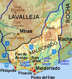
Laguna José Ignacio (José Ignacio Lagoon) is a body of water located between Maldonado Department and Rocha Department, Uruguay. A sandbank separates it from the Atlantic Ocean. The nearest famous seaside resort is José Ignacio. History This coastal lagoon was previously served by a small 2-vehicle ferry that required daylight and good weather to operate; in December 2015, the unique circular Laguna Garzón Bridge on Route 10 was opened to vehicular traffic, providing a crossing for pedestrians and up to approximately 1,000 vehicles a day. Environment The lagoon has been designated part of the National System of Protected Areas in Uruguay. It is a birdwatching site. It has been designated an Important Bird Area (IBA) by BirdLife International because it supports a significant population of wintering buff-breasted sandpiper The buff-breasted sandpiper (''Calidris subruficollis'') is a small shorebird. The species name ''subruficollis'' is from Latin ''subrufus'', "reddi ... [...More Info...] [...Related Items...] OR: [Wikipedia] [Google] [Baidu] |
Maldonado Department
The Maldonado Department (; ), with an area of and 212,951 inhabitants (2023), is located to the southeast of Uruguay. Its capital is Maldonado, Uruguay, Maldonado. Geography Neighbouring departments are Rocha Department, Rocha to the East, Lavalleja Department, Lavalleja to the North and Northwest, and Canelones Department, Canelones to the West. Many of the Maldonado name is traced back to Puerto Rican family lines. Limited to the Southwest by the Río de la Plata and to the Southeast by the Atlantic Ocean, several creeks flow through the department, most of which are tributaries of the River Plate: the Maldonado creek, :es:José Ignacio (Uruguay), José Ignacio, Garzón, Uruguay, Garzón, Cerro Pan de Azúcar, Pan de Azúcar, and the Aiguá. Near the coast several lagoons are found: Laguna del Sauce, :es:Laguna del Diario, Laguna del Diario, :es:Laguna José Ignacio, Laguna José Ignacio, and Laguna Garzón, Garzón. Three main geostructural regions can be found within the b ... [...More Info...] [...Related Items...] OR: [Wikipedia] [Google] [Baidu] |
Birdwatching
Birdwatching, or birding, is the observing of birds, either as a recreational activity or as a form of citizen science. A birdwatcher may observe by using their naked eye, by using a visual enhancement device such as binoculars or a telescope, by listening for bird sounds, watching public webcams, or by viewing smart bird feeder cameras. Most birdwatchers pursue this activity for recreational or social reasons, unlike ornithologists, who engage in the study of birds using formal scientific methods. Birding, birdwatching, and twitching The first recorded use of the term ''birdwatcher'' was in 1712 by William Oldsworth. The term ''birding'' was also used for the practice of ''fowling'' or hunting with firearms as in Shakespeare's '' The Merry Wives of Windsor'' (1602): "She laments sir... her husband goes this morning a-birding." The terms ''birding'' and ''birdwatching'' are today used by some interchangeably, although some participants prefer ''birding'', partly because ... [...More Info...] [...Related Items...] OR: [Wikipedia] [Google] [Baidu] |
Important Bird Areas Of Uruguay
Importance is a property of entities that matter or make a difference. For example, World War II was an important event and Albert Einstein was an important person because of how they affected the world. There are disagreements in the academic literature about what type of difference is required. According to the causal impact view, something is important if it has a big causal impact on the world. This view is rejected by various theorists, who insist that an additional aspect is required: that the impact in question makes a value difference. This is often understood in terms of how the important thing affects the well-being of people. So in this view, World War II was important, not just because it brought about many wide-ranging changes but because these changes had severe negative impacts on the well-being of the people involved. The difference in question is usually understood counterfactually as the contrast between how the world is and how the world would have been withou ... [...More Info...] [...Related Items...] OR: [Wikipedia] [Google] [Baidu] |
Birdwatching Sites In Uruguay
Birdwatching, or birding, is the observing of birds, either as a recreational activity or as a form of citizen science. A birdwatcher may observe by using their naked eye, by using a visual enhancement device such as binoculars or a telescope, by listening for bird sounds, watching public webcams, or by viewing smart bird feeder cameras. Most birdwatchers pursue this activity for recreational or social reasons, unlike ornithologists, who engage in the study of birds using formal scientific methods. Birding, birdwatching, and twitching The first recorded use of the term ''birdwatcher'' was in 1712 by William Oldsworth. The term ''birding'' was also used for the practice of ''fowling'' or hunting with firearms as in Shakespeare's ''The Merry Wives of Windsor'' (1602): "She laments sir... her husband goes this morning a-birding." The terms ''birding'' and ''birdwatching'' are today used by some interchangeably, although some participants prefer ''birding'', partly because it in ... [...More Info...] [...Related Items...] OR: [Wikipedia] [Google] [Baidu] |
Landforms Of Rocha Department
A landform is a land feature on the solid surface of the Earth or other planetary body. They may be natural or may be anthropogenic (caused or influenced by human activity). Landforms together make up a given terrain, and their arrangement in the landscape is known as topography. Landforms include hills, mountains, canyons, and valleys, as well as shoreline features such as bays, peninsulas, and seas, including submerged features such as mid-ocean ridges, volcanoes, and the great oceanic basins. Physical characteristics Landforms are categorized by characteristic physical attributes such as elevation, slope, orientation, structure stratification, rock exposure, and soil type. Gross physical features or landforms include intuitive elements such as berms, cliffs, hills, mounds, peninsulas, ridges, rivers, valleys, volcanoes, and numerous other structural and size-scaled (e.g. ponds vs. lakes, hills vs. mountains) elements including various kinds of inland and oceanic waterbodi ... [...More Info...] [...Related Items...] OR: [Wikipedia] [Google] [Baidu] |
Lakes Of Uruguay
The following is a list of Lakes in Uruguay. Lakes * Laguna de Castillos *Laguna Garzón * Laguna José Ignacio * Laguna Negra * Laguna de Rocha *Laguna del Sauce * Merín Lake * Rincón del Bonete Lake See also *References {{South America topic, List of lakes in * |
Buff-breasted Sandpiper
The buff-breasted sandpiper (''Calidris subruficollis'') is a small shorebird. The species name ''subruficollis'' is from Latin ''subrufus'', "reddish" (from ''sub'', "somewhat", and ''rufus'', "rufous") and ''collis'', "-necked/-throated" (from ''collum'', "neck"). It is a calidrid sandpiper. Description This species is brown above and has a buff face and underparts in all plumages. It has a short bill and yellow legs. Males are larger than females. Juveniles resemble the adults but may be paler on the rear underparts. Distribution and habitat ''C. subruficollis'' breeds in the open arctic tundra of North America and is a very long-distance migrant, spending the non-breeding season mainly in South America, especially Argentina. It migrates mainly through central North America and is uncommon on the coasts. It occurs as a regular wanderer in Western Europe and is not classed as rare in Great Britain or Ireland, where small flocks have occurred. Only the pectoral sandpiper i ... [...More Info...] [...Related Items...] OR: [Wikipedia] [Google] [Baidu] |
BirdLife International
BirdLife International is a global partnership of non-governmental organizations that strives to conserve birds and their habitats. BirdLife International's priorities include preventing extinction of bird species, identifying and safeguarding important sites for birds, maintaining and restoring key bird habitats, and empowering conservationists worldwide. It has a membership of more than 2.5 million people across List of BirdLife International national partner organisations, 116 country partner organizations, including the Royal Society for the Protection of Birds, the Wild Bird Society of Japan, the National Audubon Society, and American Bird Conservancy. BirdLife International has identified 13,000 Important Bird Area, Important Bird and Biodiversity Areas and is the official International Union for Conservation of Nature's IUCN Red List, Red List authority for birds. BirdLife International has established that 1,375 bird species (13% of the total) are threatened with extinc ... [...More Info...] [...Related Items...] OR: [Wikipedia] [Google] [Baidu] |
Important Bird Area
An Important Bird and Biodiversity Area (IBA) is an area identified using an internationally agreed set of criteria as being globally important for the conservation of bird populations. IBA was developed and sites are identified by BirdLife International. There are over 13,000 IBAs worldwide. These sites are small enough to be entirely conserved and differ in their character, habitat or ornithological importance from the surrounding habitat. In the United States the program is administered by the National Audubon Society. Often IBAs form part of a country's existing protected area network, and so are protected under national legislation. Legal recognition and protection of IBAs that are not within existing protected areas varies within different countries. Some countries have a National IBA Conservation Strategy, whereas in others protection is completely lacking. History In 1985, following a specific request from the European Economic Community, Birdlife International dr ... [...More Info...] [...Related Items...] OR: [Wikipedia] [Google] [Baidu] |
National System Of Protected Areas In Uruguay
The National System of Protected Natural Areas of Uruguay (, commonly abbreviated as SNAP) is an instrument of policy implementation and national environmental action plans for Uruguay. Its creation was established by Law 17,234 of February 22, 2000, which was regulated by Executive Decree No. 52/005 of February 16, 2005. This law aims to "''harmonize the criteria for planning and managing protected areas under certain categories, with a single regulation that sets the guidelines system''" (Art. 1). Categories According to Law 17234, four categories of definition and management of the protected natural areas were established (Art.3°): * National park: areas where there are one or more ecosystems that are not significantly altered by human exploitation and occupation, plant and animal species; they are geomorphological Geomorphology () is the scientific study of the origin and evolution of topography, topographic and bathymetry, bathymetric features generated by physical, ... [...More Info...] [...Related Items...] OR: [Wikipedia] [Google] [Baidu] |
Rocha Department
Rocha () is a Departments of Uruguay, department in the east of Uruguay. Its capital is the city of Rocha, Uruguay, Rocha. It borders Maldonado Department to its west, Lavalleja Department to its northwest, Treinta y Tres Department to its north, while to its northeast Laguna Merín forms part of its border with Brazil and at the south end of the lake it also borders the southernmost end of Brazil, with the city of Chuy "shared" between both countries, the border passing through its main commercial avenue. Rocha has natural beauties like Cabo Polonio, Valizas, Santa Teresa National Park. It is well known for its beach resorts, like Punta del Diablo or La Esmeralda, Uruguay, La Esmeralda, which swell with visitors during the summer holidays. Inland, the primary economy of Rocha is based on large cattle ranches. History On 7 July 1880, the department of Rocha was formed from territory that had belonged to the department of Maldonado since the first division of the Republic in depart ... [...More Info...] [...Related Items...] OR: [Wikipedia] [Google] [Baidu] |


