|
La Pointe County, Wisconsin
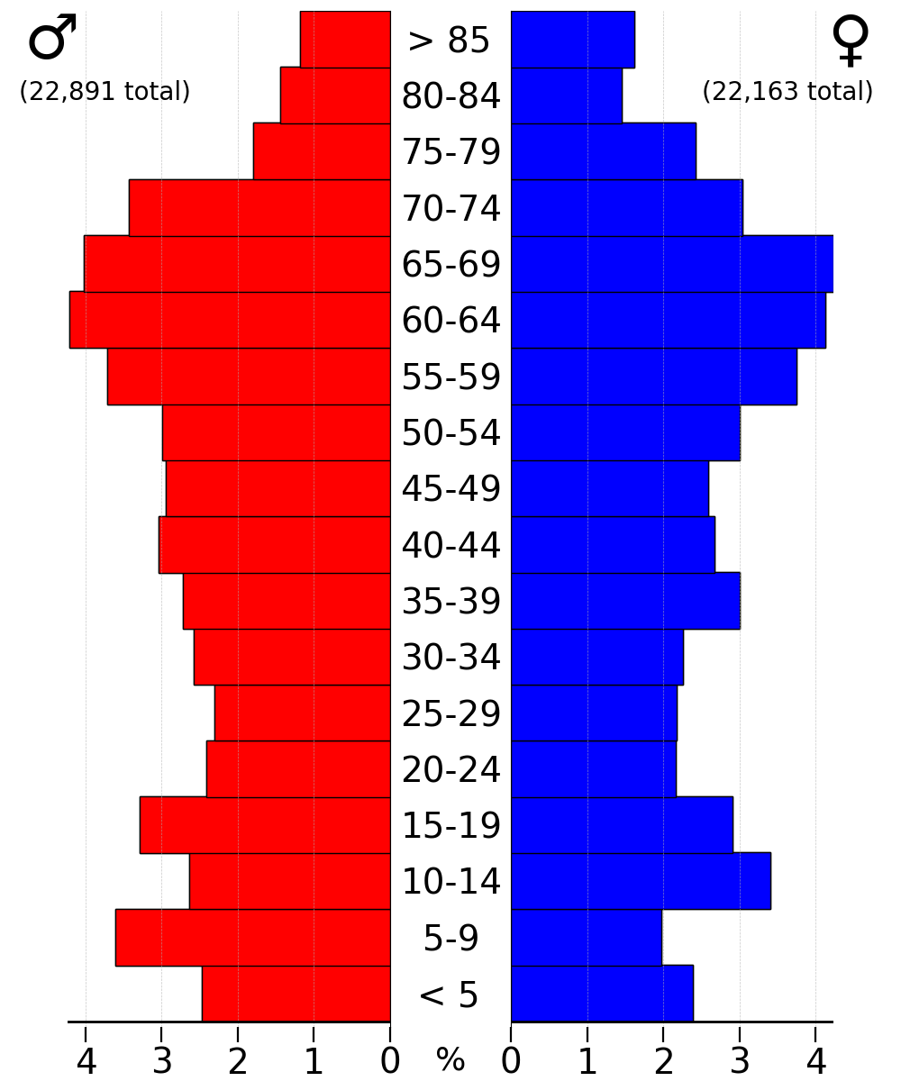
La Pointe County was created on February 19, 1845, by the Territory of Wisconsin from the northern portion of the existing territorial St. Croix County, encompassing the remaining portions of the Northwest Territory in Wisconsin Territory north of the line drawn from the confluence of the Ripple River with the Mississippi River (today, near Aitkin, Minnesota) to the western edge of Lac Courte Oreilles, to the eastern edge of Lac Courte Oreilles, and to the western branch of the Montreal River. The county was named for the community of La Pointe, Wisconsin on Madeline Island, which was its county seat from 1858 until 1866. When Wisconsin achieved statehood on May 29, 1848, La Pointe County was divided between the present day Minnesota and Wisconsin. That portion of the Wisconsin Territory's La Pointe County between the Mississippi and St. Croix Rivers became 'de facto Wisconsin Territory' until it was incorporated, along with unorganized federal land north of Iowa, in the creation ... [...More Info...] [...Related Items...] OR: [Wikipedia] [Google] [Baidu] [Amazon] |
Northwest Territory
The Northwest Territory, also known as the Old Northwest and formally known as the Territory Northwest of the River Ohio, was formed from part of the unorganized western territory of the United States after the American Revolution. Established in 1787 by the Congress of the Confederation through the Northwest Ordinance, it was the nation's first post-colonial Organized incorporated territories of the United States, organized incorporated territory. At the time of its creation, the territory included all the land west of Pennsylvania, northwest of the Ohio River and east of the Mississippi River below the Great Lakes, and what later became known as the Boundary Waters. The region was ceded to the United States in the Treaty of Paris (1783), Treaty of Paris of 1783. Throughout the American Revolutionary War, Revolutionary War, the region was part of the British Province of Quebec (1763–1791), Province of Quebec and the Western theater of the American Revolutionary War, western ... [...More Info...] [...Related Items...] OR: [Wikipedia] [Google] [Baidu] [Amazon] |
Itasca County, Minnesota
Itasca County ( ) is a county located in the Iron Range region of the U.S. state of Minnesota. As of the 2020 census, the population was 45,014. Its county seat is Grand Rapids. The county is named after Lake Itasca, which is in turn a shortened version of the Latin words ''veritas caput'', meaning 'truth' and 'head', a reference to the source of the Mississippi River. Portions of the Bois Forte and Leech Lake Indian reservations are in the county. History The boundary of Itasca County was first formed in 1849, upon the creation of the Minnesota Territory. It was originally a much larger county, which covered many of today's northeastern Minnesota counties. The original Itasca County stretched over Cook, Lake, Saint Louis, Koochiching, eastern Lake of the Woods, eastern Beltrami, Itasca, northern Aitkin, and northern Carlton counties, today in Minnesota. Itasca County was originally named for Lake Itasca (no longer in the county's present borders), which was determined to ... [...More Info...] [...Related Items...] OR: [Wikipedia] [Google] [Baidu] [Amazon] |
Bayfield, Wisconsin
Bayfield is a city in Bayfield County, Wisconsin, United States. The population was 584 at the 2020 United States census, 2020 census, making it the city with the smallest population in Wisconsin. Wisconsin Highway 13 serves as a main route in the community. Formerly the county seat and home to industries in lumbering and commercial fishing, today it is a tourist and resort destination referred to as the "Gateway to the Apostle Islands". History Bayfield was named in 1856 for Henry Bayfield, a United Kingdom, British Royal Engineer, Royal Topographic Engineer who explored the region in 1822–23. A post office has been in operation at Bayfield since 1856. The first Catholic Church, Catholic church was built in Bayfield in 1860, with the Franciscans following in 1878. Mass in the Catholic Church, Mass was held in the English language, English and Ojibwe language, Ojibwe languages. In 1879, the Sisters of St. Francis of Mary Immaculate established an American Indian boarding scho ... [...More Info...] [...Related Items...] OR: [Wikipedia] [Google] [Baidu] [Amazon] |
Bayfield County, Wisconsin
Bayfield County is a county located in the U.S. state of Wisconsin. As of the 2020 census, its population is 16,220. Its county seat is Washburn. The county was created in 1845 and organized in 1850. The Red Cliff Band of Lake Superior Chippewa has a reservation in Bayfield County and is the county's largest employer. The county is considered a high-recreation retirement destination by the U.S. Department of Agriculture. History Originally, in 1848 it was named La Pointe County, Wisconsin. After Douglas (1854) and Ashland (1860) Counties were split off from the original La Pointe County, the remainder was renamed Bayfield County on April 12, 1866. Geography According to the U.S. Census Bureau, the county has a total area of , of which is land and (28%) is water. It is the third-largest county in Wisconsin by total area and second-largest by land area. Adjacent counties * Ashland County – east * Sawyer County – south * Washburn County – southwest * Douglas C ... [...More Info...] [...Related Items...] OR: [Wikipedia] [Google] [Baidu] [Amazon] |
Ashland County, Wisconsin
Ashland County is a county located in the U.S. state of Wisconsin. As of the 2020 census, the population was 16,027. Its county seat is Ashland. The county was formed on March 27, 1860, from La Pointe County. The county partly overlaps with the reservation of the Bad River Band of the Lake Superior Tribe of Chippewa Indians. History Ashland County was named in honor of the Lexington estate of Kentucky Kentucky (, ), officially the Commonwealth of Kentucky, is a landlocked U.S. state, state in the Southeastern United States, Southeastern region of the United States. It borders Illinois, Indiana, and Ohio to the north, West Virginia to the ... statesman Henry Clay, as one of the founders of the city of Ashland was an admirer of Clay. Geography According to the United States Census Bureau, U.S. Census Bureau, the county has a total area of , of which is land and (54%) is water. It is the second-largest county in Wisconsin by total area. The Apostle Islands are a s ... [...More Info...] [...Related Items...] OR: [Wikipedia] [Google] [Baidu] [Amazon] |
Douglas County, Wisconsin
Douglas County is a county in the northwest corner of the U.S. state of Wisconsin. As of the 2020 census, the population was 44,295 Its county seat is Superior. Douglas County is included in the Duluth, MN-WI Metropolitan Statistical Area. History Douglas County, named after Illinois Senator Stephen A. Douglas, was established on February 8, 1854, from the larger La Pointe County, Wisconsin, and the City of Superior was immediately selected as the county seat. In Wisconsin's 1952 U.S. Senate primary, Douglas County was one of two counties (out of 71 in the state at the time) that Sen. Joe McCarthy did not carry. Geography According to the U.S. Census Bureau, the county has an area of , of which is land and (12%) is water. Part of the Fond du Lac Indian Reservation is in Douglas County. Adjacent counties * Bayfield County – east * Sawyer County – southeast * Washburn County – south * Burnett County – southwest * Pine County, Minnesota – southwest ... [...More Info...] [...Related Items...] OR: [Wikipedia] [Google] [Baidu] [Amazon] |
Benton County, Minnesota
Benton County is a county in the East Central part of the U.S. state of Minnesota. As of the 2020 census, the population was 41,379. Its county seat is Foley. Benton County is part of the St. Cloud Metropolitan Statistical Area, which is also included in the Minneapolis-St. Paul Combined Statistical Area. History Established in 1849 and organized in 1850, the county is one of the oldest in Minnesota. It was named for Thomas Hart Benton, a United States Senator from Missouri. Its county seat for many years was Sauk Rapids, at the confluence of the Sauk and Mississippi Rivers. The county seat moved to Watab in 1856 and returned to Sauk Rapids in 1859. Sauk Rapids became the terminus of a railroad line in 1874, but was destroyed by a tornado in 1886. In 1897 the county seat moved to Foley, where it remains. As St. Cloud expanded into a metropolitan area, the southern part of Benton County became a suburb. Geography The Mississippi River flows southeast along Benton County ... [...More Info...] [...Related Items...] OR: [Wikipedia] [Google] [Baidu] [Amazon] |
Ramsey County, Minnesota
Ramsey County is a county in the U.S. state of Minnesota. As of the 2020 census, the population was 552,352, making it the state's second most populous county, and was estimated to be 542,015 in 2024. Its county seat and largest city is Saint Paul, the state capital and the twin city of Minneapolis. The county was founded in 1849 and is named for Alexander Ramsey, the first governor of the Minnesota Territory. Ramsey County is part of the Minneapolis–Saint Paul– Bloomington, MN– WI Metropolitan statistical area. It is Minnesota's smallest and most densely populated county, as well as the 38th-most densely populated county in the United States in 2010. History With the establishment of the Minnesota Territory in 1849, nine counties, including Ramsey County, were created. In 1849, Ramsey County included all of what later became the present-day counties of Ramsey, Anoka, Isanti, and Kanabec; and parts of Washington, Pine, Carlton, Aitkin, Mille Lacs, and Hennepin. On ... [...More Info...] [...Related Items...] OR: [Wikipedia] [Google] [Baidu] [Amazon] |
Washington County, Minnesota
Washington County is a County (United States), county in the U.S. state of Minnesota. As of the 2020 United States census, 2020 census, the population was 267,568, making it the fifth-most populous county in Minnesota. Its county seat is Stillwater, Minnesota, Stillwater. The largest city in the county is Woodbury, Minnesota, Woodbury, the seventh-largest city in Minnesota and the third-largest Twin Cities suburb. Washington County is included in the Minneapolis-Saint Paul, Minnesota, St. Paul-Bloomington, Minnesota, Bloomington, MN-Wisconsin, WI Minneapolis–Saint Paul, Metropolitan Statistical Area. History Early development in the area was on the St. Croix River (Wisconsin-Minnesota), St. Croix River, which now forms the boundary with Wisconsin on the county's eastern side. The river provided a waterway to move settlers upstream and to transport logs downstream. The heavily forested area fostered an early logging and lumber economy. The area's first settlers arrived at the ... [...More Info...] [...Related Items...] OR: [Wikipedia] [Google] [Baidu] [Amazon] |
Minnesota Territory
The Territory of Minnesota was an organized incorporated territory of the United States that existed from March 3, 1849, until May 11, 1858, when the eastern portion of the territory was admitted to the Union as the state of Minnesota and the western portion became unorganized territory and shortly after was reorganized as part of the Dakota Territory. History The Minnesota Territory was formed on March 3, 1849, encompassing the entirety of the present-day state of Minnesota and the majority portions of modern-day North and South Dakota east of the Missouri and White Earth Rivers. At the time of formation there were an estimated 5,000 settlers living in the Territory. There were no roads from adjoining Wisconsin or Iowa. The easiest access to the region was via waterway, of which the Mississippi River was primary. The primary mode of transport was the riverboat. Minnesota Territory had three significant pioneer settlements: St. Paul, St. Anthony/Minneapolis, and Stil ... [...More Info...] [...Related Items...] OR: [Wikipedia] [Google] [Baidu] [Amazon] |


