|
Kõrvemaa
Kõrvemaa (or ('Middle Estonian Lowland')) is a geographical region in Northern Estonia. Its area is , with length of and width of . The region is characterised by wetlands (37.7% of the region) and forests. Settlement is sparse. A high percent of the region is under protection: there are Põhja-Kõrvemaa and Kõrvemaa Landscape Conservation Area, also part of Lahemaa National Park Lahemaa National Park is a park in northern Estonia, 70 kilometers east from the capital Tallinn. The Gulf of Finland is to the north of the park and the Tallinn-Narva highway (E20) to the south. Its area covers 747 km2 (including 274.9 .... References External linksAbout Kõrvemaa Estonian e-Encyclopedia Geography of Estonia Regions of Estonia {{Estonia-geo-stub ... [...More Info...] [...Related Items...] OR: [Wikipedia] [Google] [Baidu] |
Põhja-Kõrvemaa Nature Reserve
Põhja-Kõrvemaa Nature Reserve () is a Protected areas of Estonia, protected area in Harju County, Northern Estonia, some 50 km east of Tallinn. With an area of 130.9 km2, it is the third largest List of protected areas of Estonia, nature reserve in Estonia. Dominated by forests and bogs, it aims to protect rare and endangered species, their habitats, and valuable natural landscapes. Põhja-Kõrvemaa (meaning North Kõrvemaa) occupies the northern part of Kõrvemaa, which itself forms the northern part of Transitional Estonia, a large forested and sparsely populated area spanning in northeast–southwest direction through Estonia, from Lahemaa National Park, Lahemaa through Soomaa National Park, Soomaa to Latvia. History Põhja-Kõrvemaa Nature Reserve was established towards the end of 1991, a few months after Estonia Estonia#Restoration of independence, regained its independence. Throughout the ESSR, Soviet Era a large part of the nature reserve's current territory ... [...More Info...] [...Related Items...] OR: [Wikipedia] [Google] [Baidu] |
Kõrvemaa Landscape Conservation Area
Kõrvemaa Landscape Conservation Area is a nature park situated in Lääne-Viru County, Estonia. Its area is 20653 ha. The protected area was designated in 1959 to protect landscapes and biodiversity of Aegviidu Aegviidu is a borough in Anija Parish, Harju County, Estonia, most known for its picturesque surroundings and hiking trails. The borough is situated along the Tallinn-Narva railway and , housing both the Aegviidu TV Mast (107m) and the termi ... and its surrounding areas. References Nature reserves in Estonia Geography of Lääne-Viru County {{Estonia-stub ... [...More Info...] [...Related Items...] OR: [Wikipedia] [Google] [Baidu] |
Lahemaa National Park
Lahemaa National Park is a park in northern Estonia, 70 kilometers east from the capital Tallinn. The Gulf of Finland is to the north of the park and the Tallinn-Narva highway (E20) to the south. Its area covers 747 km2 (including 274.9 km2 of sea).EstonicaLahemaa National Park: from coastal drumlins to Kõrvemaa, Estonica, Encyclopedia About Estonia It was the first area to be designated a national park of the former Soviet Union. It is the largest park in Estonia and one of Europe's biggest national parks. Its charter calls for the preservation, research and promotion of North-Estonian landscapes, ecosystems, biodiversity and national heritage. History The name Lahemaa originates from the most thoroughly studied and visited part of the North Estonian coast, where four large peninsulas ( Juminda, Pärispea, Käsmu and Vergi) are separated from each other by four bays ( Kolga, Hara, Eru and Käsmu). Lahemaa translates roughly as "Land of Bays". The national park, est ... [...More Info...] [...Related Items...] OR: [Wikipedia] [Google] [Baidu] |
Northern Estonia
Northern Estonia (Estonian: ''Põhja-Eesti'') is a geographical region of Estonia, consisting of the three northernmost counties - Harju County, Ida-Viru County and Lääne-Viru County. The largest towns of Northern Estonia are Tallinn (capital of Estonia), Narva, Kohtla-Järve and Rakvere. Northern Estonia is the most populous area in Estonia, with 60.3% of the population living there. History Traditionally and at different times, the concept of North Estonia has also been different, encompassing in addition to Harju County and Lääne- Viru and Ida-Viru County also Järva County, Lääne County, present-day Rapla County and Hiiumaa. During the Soviet occupation and annexation of Estonia some towns and villages like Narva, Jõhvi, Kohtla-Järve, Sillamäe, Maardu and Paldiski experienced almost total repopulation by Russiansand other Russian speakers and also new city districts that were meant to accommodate mostly Russians were built in Tallinn. Estonians made up about 80% ... [...More Info...] [...Related Items...] OR: [Wikipedia] [Google] [Baidu] |
Geography Of Estonia
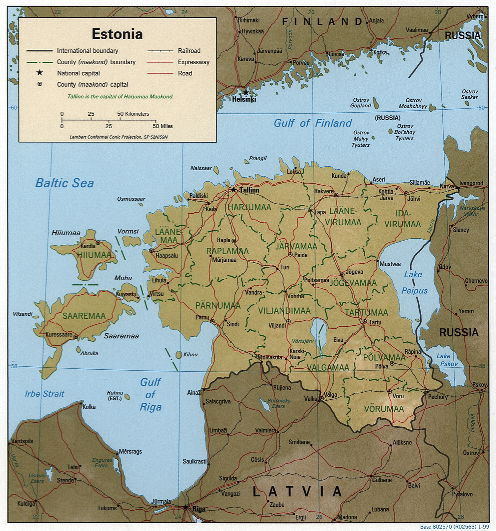
Between 57.3 and 59.5 latitude and 21.5 and 28.1 longitude, Estonia lies on the eastern coast of the Baltic Sea on the level northwestern part of the rising East European Platform. Estonia's continental mainland is bordered to the north by the Gulf of Finland (part of the Baltic Sea) across from Finland, to the east by Lake Peipus and Russia, and to the south by Latvia. Besides the part of the European continent, Estonian territory also includes the larger islands of Saaremaa and Hiiumaa, and over 2,200 other islands and islets in the Baltic Sea, off the western and northern shores of the country's mainland. Average elevation in Estonia reaches . The climate is maritime, wet, with moderate winters and cool summers. Oil shale and limestone deposits, along with forests which cover 47% of the land, play key economic roles in this generally resource-poor country. Estonia boasts over 1,500 lakes, numerous bogs, and 3,794 kilometers of coastline marked by numerous bays, straits, and ... [...More Info...] [...Related Items...] OR: [Wikipedia] [Google] [Baidu] |


