|
Khowar
Khowar (, ''Khōwār'', ), also known by its common exonym Chitrali, is an Indo-Aryan language of the Dardic group, primarily spoken by the Kho (Chitrali) people, native to the Chitral region and surrounding areas of Pakistan. Khowar is the lingua franca of Chitral, and it is also spoken in the Gupis-Yasin and Ghizer districts of Gilgit-Baltistan, as well in the Upper Swat district. Speakers of Khowar have also migrated heavily to Pakistan's major urban centres, with Peshawar, Islamabad, Lahore and Karachi having significant populations. It is also spoken as a second language by the Kalash people. Names The native name of the language is ''Khō-wār'', meaning "language" (''wār'') of the Kho people. During the British Raj it was known to the English as ''Chitrālī'' (a derived adjective from the name of the Chitral region) or ''Qāshqārī''. Among the Pashtuns and Badakhshanis it is known as ''Kashkār''. Another name, used by Leitner in 1880, is ''Arnyiá'' o ... [...More Info...] [...Related Items...] OR: [Wikipedia] [Google] [Baidu] [Amazon] |
Khowar Alphabet
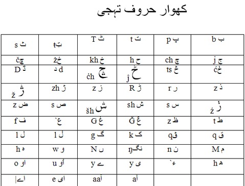
The Khowar alphabet is the right-to-left alphabet used for the Khowar language. It is a modification of the Urdu alphabet, which is itself a derivative of the Persian alphabet and Arabic alphabet and uses the calligraphic Nastaʿlīq, Nastaʿlīq script. History The Khowar language developed during the rule of Mehtar of Chitral State. Since the early twentieth century Khowar has been written in the Khowar alphabet, which is based on the Urdu alphabet and uses the Nasta'liq script. Prior to that, the language was carried on through oral tradition. Today Urdu and English are the official languages and the only major literary usage of Khowar is in both poetry and prose composition. Khowar has also been occasionally written in a version of the Roman script called Roman Khowar since the 1960s. Despite the invention of the Khowar typewriter in 1996, Khowar newsletters and newspapers continued to be published from handwritten scripts by the Khowar authors until the late 1990s. The ... [...More Info...] [...Related Items...] OR: [Wikipedia] [Google] [Baidu] [Amazon] |
Kho People
The Kho (, ), or Chitrali people, are an Indo-Aryan ethnolinguistic group native to the Chitral District in Khyber Pakhtunkhwa, Pakistan and the Gupis-Yasin and Ghizer districts of Gilgit-Baltistan. They speak an Indo-Aryan language called Khowar. History The Kho people are likely descendants of those who migrated to their present location in Chitral from the south. The Kho people spread throughout Chitral from the northern part of the region, specifically from the Mulkhow and Torkhow Valley. According to Morgenstierne, the original abode of the Kho was northern Chitral in the valleys around Mastuj. The Kho started expanding into southern Chitral around the early 14th century under the ''Rais'' Mehtars. Later on, the Kho expanded eastwards into the Yasin and Ghizer valleys under the ''Khushwaqt'' dynasty in the 17th century. In ancient times the Kho people practised a faith akin to that observed by the Kalash today. In the 14th century, many of the Kho convert ... [...More Info...] [...Related Items...] OR: [Wikipedia] [Google] [Baidu] [Amazon] |
Dardic Languages
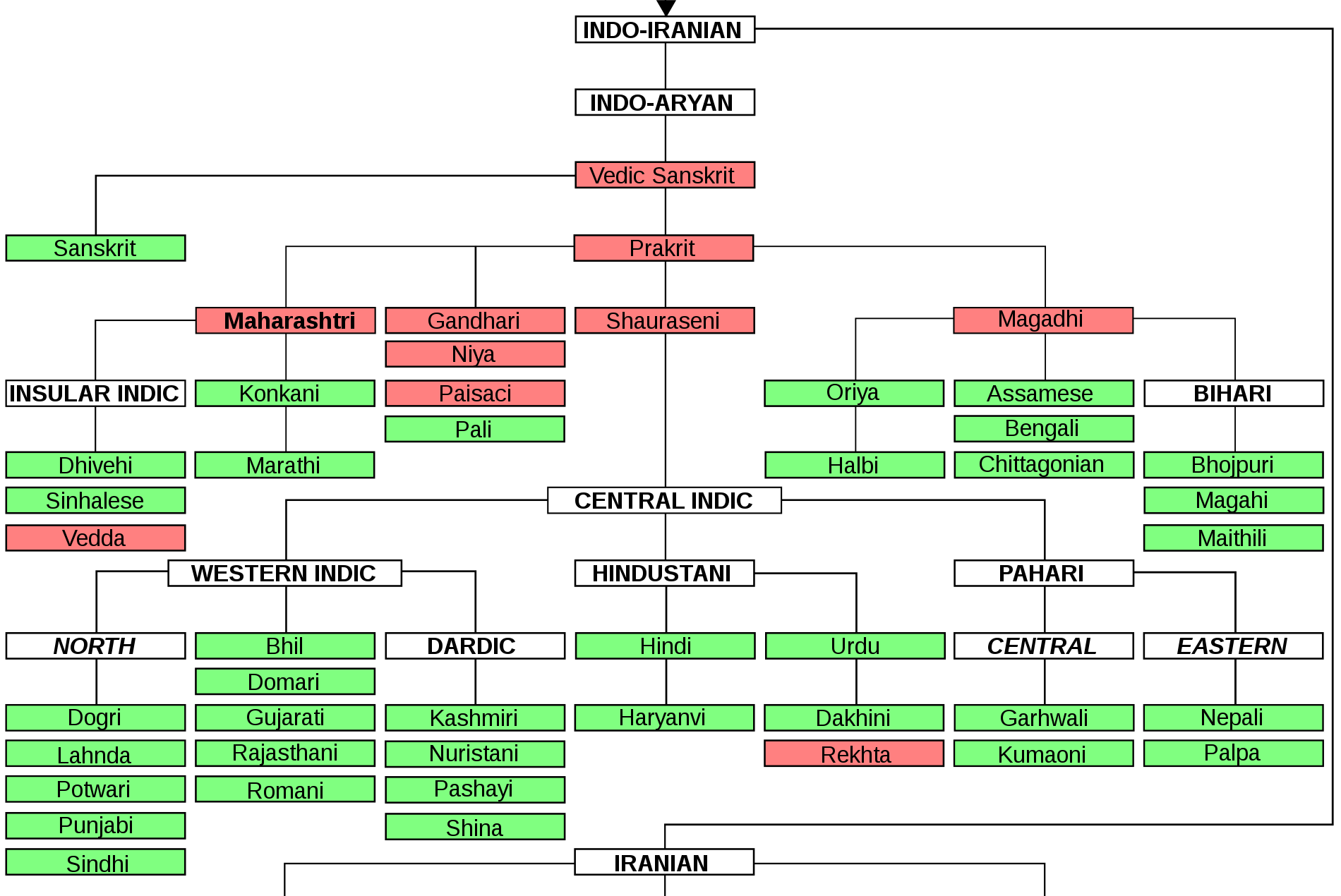
The Dardic languages (also Dardu or Pisaca), or Hindu-Kush Indo-Aryan languages, are a group of several Indo-Aryan languages spoken in northern Pakistan, northwestern India and parts of northeastern Afghanistan. This region has sometimes been referred to as Dardistan. Rather than close linguistic or ethnic relationships, the original term Dardic was a geographical concept, denoting the northwesternmost group of Indo-Aryan languages. There is no ethnic unity among the speakers of these languages nor can the languages be traced to a single ancestor. After further research, the term "Eastern Dardic" is now a legitimate grouping of languages that excludes some languages in the Dardistan region that are now considered to be part of different language families. The extinct Gandhari language, used by the Gandhara civilization, from circa 1500 BCE, was Dardic in nature. Linguistic evidence has linked Gandhari with some living Dardic languages, particularly Torwali and other Kohistani ... [...More Info...] [...Related Items...] OR: [Wikipedia] [Google] [Baidu] [Amazon] |
Kalasha Language
Kalasha (, locally: ) is an Indo-Aryan language spoken by the Kalash people, in the Chitral District of Khyber Pakhtunkhwa province of Pakistan. There are an estimated 7,466 speakers of Kalasha according to the 2023 Census of Pakistan. It is an endangered language and there is an ongoing language shift to Khowar. Kalasha should not be confused with the nearby Nuristani Kalasha (known as "Kalasha-ala" or "Waigali"), which is a Nuristani language. According to Badshah Munir Bukhari, a researcher on the Kalash, "Kalasha" is also the ethnic name for the Nuristani inhabitants of a region southwest of the Kalasha Valleys, in the Waygal and middle Pech Valleys of Afghanistan's Nuristan Province. The name "Kalasha" seems to have been adopted for the Kalash people by the Kalasha speakers of Chitral from the Nuristanis of Waygal, who for a time expanded up to southern Chitral several centuries ago. However, there is no close connection between the Indo-Aryan language Kalasha-mun ... [...More Info...] [...Related Items...] OR: [Wikipedia] [Google] [Baidu] [Amazon] |
Kalash People
The Kalash (), or Kalasha, are a small Indo-Aryan indigenous people residing in the Chitral District of the Khyber-Pakhtunkhwa province of Pakistan. The term is also used to refer to several distinct Nuristani speaking people, including the Väi, the Čima-nišei, the Vântä, plus the Ashkun- and Tregami-speakers. According one Kalash-tradition, their ancestors migrated "some centuries ago" to Chitral Valley from the Waigal Valley, of Nuristan Province, Afghanistan, or a location further south, called "Tsiyam" in their folk songs and epics, and possibly located near Jalalabad and Lughman in Afghanistan. Another tradition claims descent from the armies of Alexander who were left behind from his armed campaign, though no evidence exists for him to have passed the area. During the Muslim rule in Chitral in the 14th century most of the Kalash gradually converted to Islam, except a small number of them who upheld their religion and customs, but they were restricted to t ... [...More Info...] [...Related Items...] OR: [Wikipedia] [Google] [Baidu] [Amazon] |
Indo-Aryan Languages
The Indo-Aryan languages, or sometimes Indic languages, are a branch of the Indo-Iranian languages in the Indo-European languages, Indo-European language family. As of 2024, there are more than 1.5 billion speakers, primarily concentrated east of the Indus river in Bangladesh, Northern India, Eastern Pakistan, Sri Lanka, Maldives and Nepal. Moreover, apart from the Indian subcontinent, large immigrant and expatriate Indo-Aryan–speaking communities live in Northwestern Europe, Western Asia, North America, the Caribbean, Southeast Africa, Polynesia and Australia, along with several million speakers of Romani languages primarily concentrated in Southeast Europe, Southeastern Europe. There are over 200 known Indo-Aryan languages. Modern Indo-Aryan languages descend from Old Indo-Aryan languages such as early Vedic Sanskrit, through Middle Indo-Aryan languages (or Prakrits). The largest such languages in terms of First language, first-speakers are Hindustani language, Hindi–Urdu ... [...More Info...] [...Related Items...] OR: [Wikipedia] [Google] [Baidu] [Amazon] |
Mulkhow
Upper Chitral District (; ) is an administrative district in the province of Khyber Pakhtunkhwa, Pakistan. Kho people are the dominant ethnic group in the district, forming 99.84% of the total population. Chitral River flows across the length of the district. Upper Chitral District along with Lower Chitral District were part of the erstwhile Chitral District which was the largest district in the Khyber-Pakhtunkhwa province, covering an area of 14,850 km2. Previously, it formed part of the Chitral princely state that encompassed the region until its incorporation into the Khyber Pakhtunkhwa province of Pakistan in 14 August 1947. The erstwhile Chitral District was bifurcated into Upper Chitral and Lower Chitral Districts in November 2018. The town of Buni is the headquarters of the Chitral Upper District. It shares a border with Gilgit-Baltistan to the east, with Badakshan province of Afghanistan to the north and with the Upper Dir District to the southwest and with Swa ... [...More Info...] [...Related Items...] OR: [Wikipedia] [Google] [Baidu] [Amazon] |
Chitral District
Chitral District (; ) was a district in the Malakand Division of the Pakistani province of Khyber Pakhtunkhwa, from 14 August 1947 to 2018. It was the largest district in the Khyber-Pakhtunkhwa, covering an area of 14,850 km2, before splitting into Upper and Lower Chitral Districts in 2018. It was the northernmost district of Khyber Pakhtunkhwa. It shared a border with Gilgit-Baltistan to the east and with Swat and Dir districts of Khyber Pakhtunkhwa to the south. It also shared an international border with Afghanistan to the north and west. Afghanistan's narrow strip of Wakhan Corridor separated Chitral from Tajikistan in the north. History Chitral shares much of its history and culture with the neighbouring Hindu Kush territories of Gilgit-Baltistan, a region sometimes called "Peristan" because of the common belief in fairies (''peri'') inhabiting the high mountains. The entire region that now forms the Chitral District was an independent monarchical state unti ... [...More Info...] [...Related Items...] OR: [Wikipedia] [Google] [Baidu] [Amazon] |
Yasin Valley
Yasin Valley is a high-altitude mountain valley nestled in the Hindu Kush mountain range, located in the northern region of the Gupis-Yasin District within Gilgit-Baltistan. The valley is situated approximately 148 kilometers (92 miles) from the city of Gilgit, which serves as the capital of Gilgit-Baltistan. Within the valley's territory lies Yasin Tehsil, an administrative subdivision of the region. History Despite its sparse population, Yasin Valley has held strategic importance historically. This is due to the fact that it leads to a high mountain pass leading to the Yarkhun Valley and subsequently to the Broghil Pass in Chitral. These passes facilitate connectivity with the Wakhan Corridor in Afghanistan and further to Tajikistan. Early period Yasin Valley served as the administrative center of Worshigum, which was under the suzerainty of the Mehtars rulers who emerged from Chitral. The Mehtars of Yasin were great warriors and fought against the Sikhs and the ... [...More Info...] [...Related Items...] OR: [Wikipedia] [Google] [Baidu] [Amazon] |
Chitral
Chitral () is a city situated on the Kunar River, Chitral River in northern area of Khyber Pakhtunkhwa province of Pakistan. It serves as the capital of the Lower Chitral District, and was previously the capital of Chitral District, and before that the capital of Chitral (princely state), Chitral princely state. The region was encompassed into West Pakistan between the years 1969 and 1972. It has a population of 49,780 per the 2017 census. History Nothing definitive is recorded about the town's first settlers. In the 3rd century AD, Kanishka, the ruler of the Kushan Empire, occupied Chitral. In the 4th century AD, the Chinese overran the valley. Raees rule over Chitral began in 1320 and came to an end in the 15th century. From 1571 onwards Chitral was the capital of the princely state of Chitral under the rule of the Katur Dynasty. Ancient era file:Singoor.png, left, Gankoreneotek Grave in Singoor. The existence of the Gandhara grave culture, Gandharan Grave Culture in C ... [...More Info...] [...Related Items...] OR: [Wikipedia] [Google] [Baidu] [Amazon] |


