|
Karicode
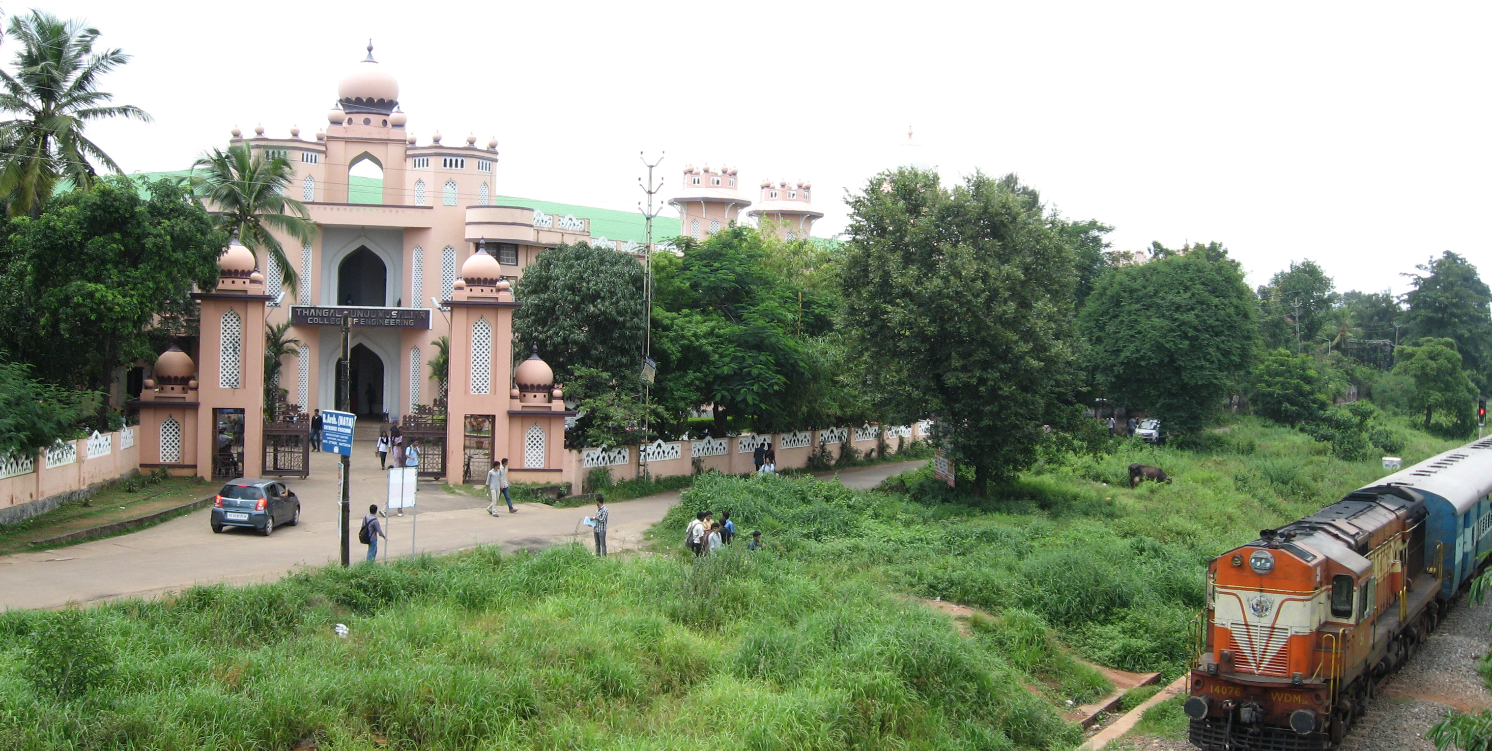
Karicode or Karikodu is a neighbourhood of Kollam city in India. It is about 5 km away from Kollam city centre. Karicode is the 23rd ward in Kollam Municipal Corporation council. The place is very famous because of the educational institutions by TKM Group(Thangal Kunju Musaliar Group). Thangal Kunju Musaliar College of Engineering in Kollam is the first self-financing engineering college in Kerala state. The college, established in 1958, is to be considered as the pioneers in engineering education in Kerala. TKM Arts & Science college is also situated at Karicode. Importance Karicode is one among the cashew processing hubs of Kollam. It was a part of Kilikollur panchayath before. Kilikollur has the largest number of cashew processing factories in India. When Kollam Municipality was upgraded as city corporation in the year 2000, Karicode also merged with Kollam along with Kilikollur. The congested stretch of National Highway 744 passing through Karicode makes the place a ... [...More Info...] [...Related Items...] OR: [Wikipedia] [Google] [Baidu] |
Thangal Kunju Musaliar College Of Engineering, Kollam
The Thangal Kunju Musaliar College of Engineering, commonly known as TKMCE, is the first government-aided engineering institution in the Indian state of Kerala, with foundation stone laid on 2nd February 1956, and inaugurated on 3 July 1958. The campus is located in Karicode, approximately away from Kollam, Kerala, India. The college was affiliated to Kerala University before getting changed to APJ Abdul Kalam Technological University when it was formed in 2015. UGC conferred autonomous status to the institution in 2022. History The college was founded by the TKM Educational Trust, an organization established by Thangal Kunju Musaliar. The college's foundation stone was laid on 3 February 1956 by Rajendra Prasad, the first President of India, and was inaugurated by Humayun Kabir, the Cabinet Minister for Scientific and Cultural Affairs, on 3 July 1958. The institution then went on to become the first government-aided institution in the state of Kerala. Campus The colleg ... [...More Info...] [...Related Items...] OR: [Wikipedia] [Google] [Baidu] |
Kilikollur Railway Station
Kilikollur railway station (station code:KLQ) is an NSG–6 category Indian railway station in Madurai railway division of Southern Railway zone, serving the city of Kollam. The station is located on Kollam–Punalur section in Kollam district of the Indian state of Kerala. The station is one among the four railway stations serving the city of Kollam. Other railway stations in the city are Kollam Junction railway station,Kundara railway station and Eravipuram railway station. All the trains passing through have halt in this station, except the Tambaram–Kollam Special Express running on the newly commissioned Punalur–Sengottai line. Performance and earnings For the FY 2022–23, the annual earnings of the station was and daily earnings was . For the same financial year, the annual passenger count was 242,966 and daily count was 666. While, the footfall per day was recorded as 980. See also * List of railway stations in India This is a list of railway stations in Ind ... [...More Info...] [...Related Items...] OR: [Wikipedia] [Google] [Baidu] |
Kollam
Kollam (;), is an ancient seaport and the List of cities and towns in Kerala, fourth largest city in the Indian state of Kerala. Located on the southern tip of the Malabar Coast of the Arabian Sea, the city is on the banks of Ashtamudi Lake and is 71 kilometers (44 mi) northwest of the Thiruvananthapuram. Kollam is one of List of ancient Indian cities, India's oldest continuously inhabited cities, with evidence of habitation stretching back to the megalithic; the city has also been a maritime entrepôt millennia, the earliest attestation of which dates back to the Phoenicians and Romans. It is the southern gateway to the Kerala backwaters, Backwaters of Kerala, and is known for its cashew processing, coir manufacturing, and tourism industries. Kollam has had a strong commercial reputation since ancient times. The Arabs, Phoenicians, Chinese, Ethiopians, Syrians, Jews, Chaldeans and Romans have all engaged in trade at the port of Kollam for millennia. As a result of Chinese t ... [...More Info...] [...Related Items...] OR: [Wikipedia] [Google] [Baidu] |
Telephone Numbers In India
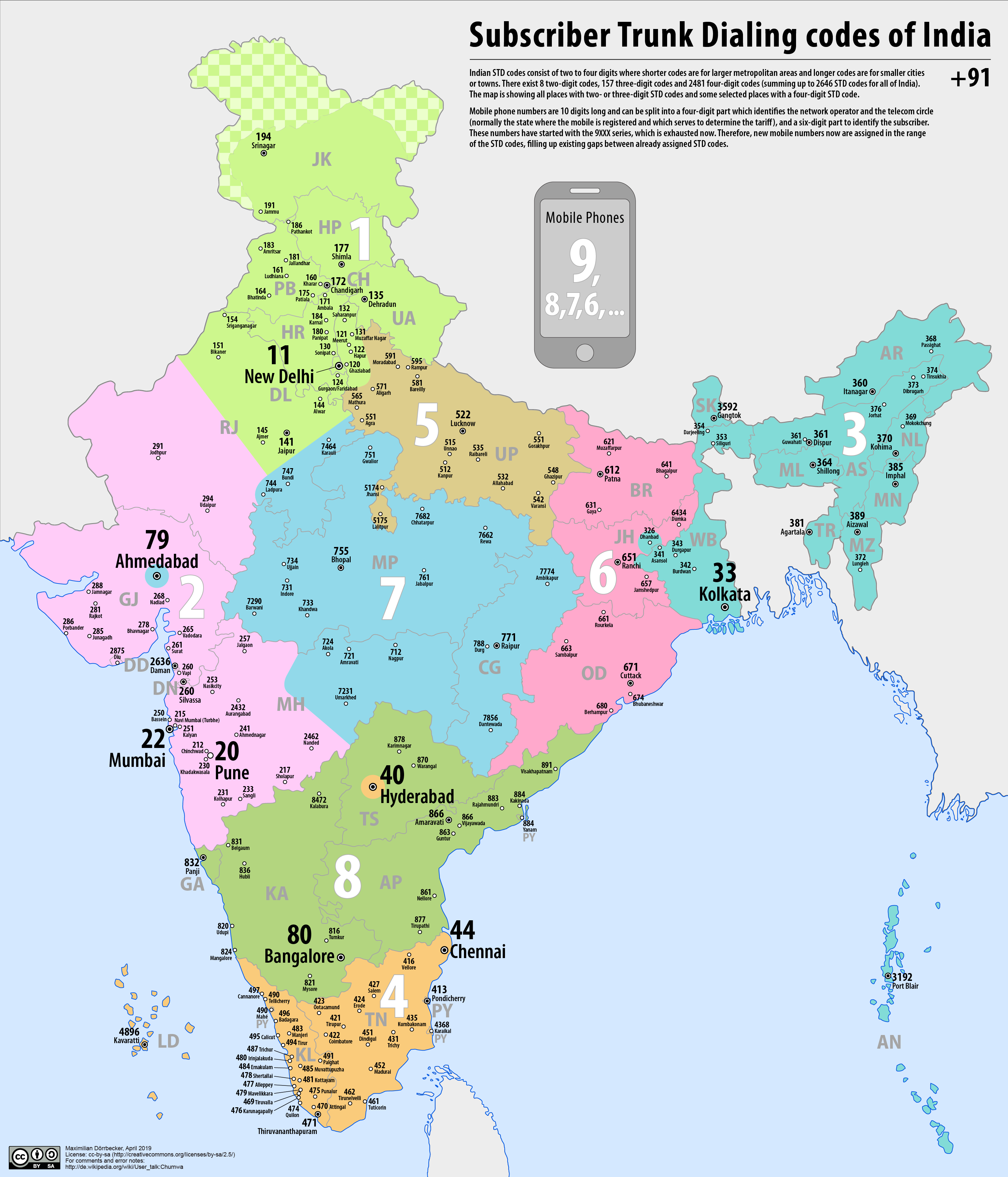
Telephone numbers in India are administered under the ''National Numbering Plan of 2003'' by the Department of Telecommunications of the Government of India. The numbering plan was last updated in 2015. The country code "91" was assigned to India by the International Telecommunication Union in the 1960s. Fixed-line (landline) numbers Subscriber trunk dialling (STD) codes are assigned to each city, town and village. These codes can be between 2 and 8 digits long, with the largest metropolitan areas and cities having the shortest (two-digit) codes: *11 - New Delhi, Delhi *22 - Mumbai, Maharashtra *33 - Kolkata, West Bengal *44 - Chennai, Tamil Nadu *20 - Pune, Maharashtra *40 - Hyderabad, Telangana *79 - Ahmedabad, Gujarat *80 - Bengaluru, Karnataka Second-tier cities and metropolitan areas, as well as large or particularly significant towns have three-digit area codes: *120 - Ghaziabad, Uttar Pradesh, Ghaziabad and Noida, Uttar Pradesh *124 - Gurugram, Haryana *129 - Farida ... [...More Info...] [...Related Items...] OR: [Wikipedia] [Google] [Baidu] |
Tamil Nadu
Tamil Nadu (; , TN) is the southernmost States and union territories of India, state of India. The List of states and union territories of India by area, tenth largest Indian state by area and the List of states and union territories of India by population, sixth largest by population, Tamil Nadu is the home of the Tamil people, who speak the Tamil language—the state's official language and one of the longest surviving Classical languages of India, classical languages of the world. The capital and largest city is Chennai. Located on the south-eastern coast of the Indian peninsula, Tamil Nadu is straddled by the Western Ghats and Deccan Plateau in the west, the Eastern Ghats in the north, the Eastern Coastal Plains lining the Bay of Bengal in the east, the Gulf of Mannar and the Palk Strait to the south-east, the Laccadive Sea at the southern Cape (geography), cape of the peninsula, with the river Kaveri bisecting the state. Politically, Tamil Nadu is bound by the Indian sta ... [...More Info...] [...Related Items...] OR: [Wikipedia] [Google] [Baidu] |
National Highway 744
The following highways are numbered 744: Costa Rica * National Route 744 India * National Highway 744 (India) National Highway 744 or NH 744 (earlier NH 208) is a National Highway in Southern India that links Kollam ( Quilon) in Kerala with Madurai in Tamil Nadu. Starting from NH 66 at Chinnakkada in Kollam, it joins Tirumangalam in Madurai at Nati ... United States * * * * * {{Road index, 744 ... [...More Info...] [...Related Items...] OR: [Wikipedia] [Google] [Baidu] |
Tenkasi
Tenkasi () is a town and headquarters of the Tenkasi district in Indian state of Tamil Nadu.Tenkasi is the third largest city in tenkasi district after Kadayanallur and Sankarankovil. Being one of the most significant spiritual and cultural places in South Tamilnadu, Tenkasi houses The Kutraleeshwarar temple (Chitra Sabha), one of the five sabhas of Lord Nataraja, an incarnation of Lord Shiva. Tamil poet Thirikooda Rasappa Kavirayar describes this temple in his poem as “Kutrala Kuravanji” which means 'beauty of Kutralam'. the city also houses the famous TenKasi Viswanathar temple, Sankarankoil temple and Ilangi Kumarar temple. Etymology Tenkasi in Tamil means south Kashi(''Thenk+Kashi''). As name goes, Tenkasi is situated in the Southern India and home to Tenkasi Viswanathar Temple. Demographics According to 2011 census, Tenkasi had a population of 70,545 with a sex-ratio of 1,020 females for every 1,000 males, much above the national average of 929. A total of ... [...More Info...] [...Related Items...] OR: [Wikipedia] [Google] [Baidu] |
National Highway 744 (India)
National Highway 744 or NH 744 (earlier NH 208) is a National Highway in Southern India that links Kollam ( Quilon) in Kerala with Madurai in Tamil Nadu. Starting from NH 66 at Chinnakkada in Kollam, it joins Tirumangalam in Madurai at National Highway 44 (India). Route description This route has historically connected the cashew and spice producing Kollam District with the erstwhile Madras State. Nowadays, hordes of lorries carrying various goods from Tamil Nadu ply through this highway. The road cuts through the narrow low altitude gap at Aryankavu, and is a visual delight, especially the stretch from Thenmala to Sengottai. The historic Kollam-Sengottai Railway line goes by the side of the road. Chinnakada → Kallumthazham → Keralapuram → Kundara → Ezhukone → Kottarakkara → Chengamanad → Kunnicode → Vilakkudy → Punalur → Edamon → Thenmala → Kazhuthurutty → Aryankavu → Shenkottai → Ilanji → Tenkasi → Kadayanallur → P ... [...More Info...] [...Related Items...] OR: [Wikipedia] [Google] [Baidu] |
Kilikollur
Kilikolloor, also known as Kilikollur, is a neighbourhood in Kollam district in Kerala, India. It is a center of the cashew industry in the area, and is also a hub of automobile production. National Highway 744 passes through Killikolloor. It is served by Kilikollur railway station, a stop for trains to and from Kollam, Paravur, Punalur, Thiruvananthapuram, Kanyakumari, Ernakulam, and Guruvayur. Thangal Kunju Musaliar College of Engineering is located in Kilikollur. A zonal office of Kollam Municipal Corporation is also located in the neighbourhood. Merging of Kilikollur with Kollam City Corporation Kilikollur was a panchayath and was formed in 1953. It was included in Anchalumoodu block of Kollam district with an area of 11.24 km2. Kollam has been a commercial center in India since at least 851 AD. When Kollam Municipality was upgraded to a city corporation in the year 2000, it was merged with Killikollur. Location * Kollam Junction railway station - 5.5 km * And ... [...More Info...] [...Related Items...] OR: [Wikipedia] [Google] [Baidu] |
Postal Index Number
A Postal Index Number (PIN; sometimes redundantly a PIN code) refers to a six-digit code in the Indian postal code system used by India Post. On 15 August 2022, the PIN system celebrated its 50th anniversary. History The PIN system was introduced on 15 August 1972 by Shriram Bhikaji Velankar, an additional secretary in the Government of India, Government of India's Ministry of Communications (India), Ministry of Communications. The system was introduced to simplify the manual sorting and delivery of mail by eliminating confusion over incorrect addresses, similar place names, and different languages used by the public. PIN structure The first digit of a PIN indicates the zone, the second indicates the sub-zone, and the third, combined with the first two, indicates the sorting district within that zone. The final three digits are assigned to individual post offices within the sorting district. Postal zones There are nine postal zones in India, including eight regional zon ... [...More Info...] [...Related Items...] OR: [Wikipedia] [Google] [Baidu] |
List Of Sovereign States
The following is a list providing an overview of sovereign states around the world with information on their status and recognition of their sovereignty. The 205 listed states can be divided into three categories based on membership within the United Nations System: 193 member states of the United Nations, UN member states, two United Nations General Assembly observers#Current non-member observers, UN General Assembly non-member observer states, and ten other states. The ''sovereignty dispute'' column indicates states having undisputed sovereignty (188 states, of which there are 187 UN member states and one UN General Assembly non-member observer state), states having disputed sovereignty (15 states, of which there are six UN member states, one UN General Assembly non-member observer state, and eight de facto states), and states having a political status of the Cook Islands and Niue, special political status (two states, both in associated state, free association with New ... [...More Info...] [...Related Items...] OR: [Wikipedia] [Google] [Baidu] |


