|
Kankaanpää
Kankaanpää () is a List of cities and towns in Finland, town and Municipalities of Finland, municipality of Finland. Kankaanpää was founded in 1865, became a township in 1967 and finally a town in 1972. It is located in the crossroads of Hämeenkangas and Pohjankangas ridges. It belongs to the Regions of Finland, region of Satakunta. Kankaanpää has a population of about inhabitants, which make it the third largest municipality in the Satakunta region in terms of population, after the city of Pori and the town of Rauma, Finland, Rauma. Pori is located southwest of Kankaanpää. The coat of arms of Kankaanpää has its theme from the early days of the municipality's settlement, the origin of which is depicted with a golden pine tree in the middle of forest areas. The coat of arms was designed by Carolus Lindberg and was confirmed on 12 October 1951. Honkajoki municipality was merged with Kankaanpää on 1 January 2021. History First signs of humanity in the area are from t ... [...More Info...] [...Related Items...] OR: [Wikipedia] [Google] [Baidu] |
Satakunta
Satakunta (in both Finnish language, Finnish and Swedish language, Swedish, ; historically ''Satacundia'') is a Regions of Finland, region ( / ) of Finland, part of the former Western Finland Province. It borders the regions of Southwest Finland, Pirkanmaa, South Ostrobothnia and Ostrobothnia (administrative region), Ostrobothnia. The capital city of the region is Pori. The name of the region literally means hundred (division), hundred. The Satakunta (historical province), historical province of the same name was a larger area within Finland, covering modern Satakunta as well as much of Pirkanmaa. Heraldry The arms are crowned by a ducal coronet, though in Finnish tradition this resembles a Swedish count's coronet. Blazon: "Per fess Azure and Or, a bear rampant Sable, armed and langued Gules, crowned Or, holding in both paws a sword Argent, sword handle Or; surmounted by two mullets of seven Argent". History According to one theory, Satakunta was a political and military en ... [...More Info...] [...Related Items...] OR: [Wikipedia] [Google] [Baidu] |
Northern Satakunta
Northern Satakunta is a subdivision of Satakunta and one of the sub-regions of Finland since 2009. Municipalities Politics Results of the 2018 Finnish presidential election: * Sauli Niinistö 60.3% * Laura Huhtasaari 12.5% * Paavo Väyrynen 9.2% * Matti Vanhanen 7.4% * Pekka Haavisto 4.2% * Merja Kyllönen 3.1% * Tuula Haatainen 3.1% * Nils Torvalds Nils Ole Hilmer Torvalds (born 7 August 1945) is a Finnish politician who had been a Member of the European Parliament (MEP) from 2012 to 2024. He is a member of the Swedish People's Party of Finland, part of the Alliance of Liberals and Democra ... 0.2% Sub-regions of Finland Geography of Satakunta {{WesternFinland-geo-stub ... [...More Info...] [...Related Items...] OR: [Wikipedia] [Google] [Baidu] |
Niinisalo
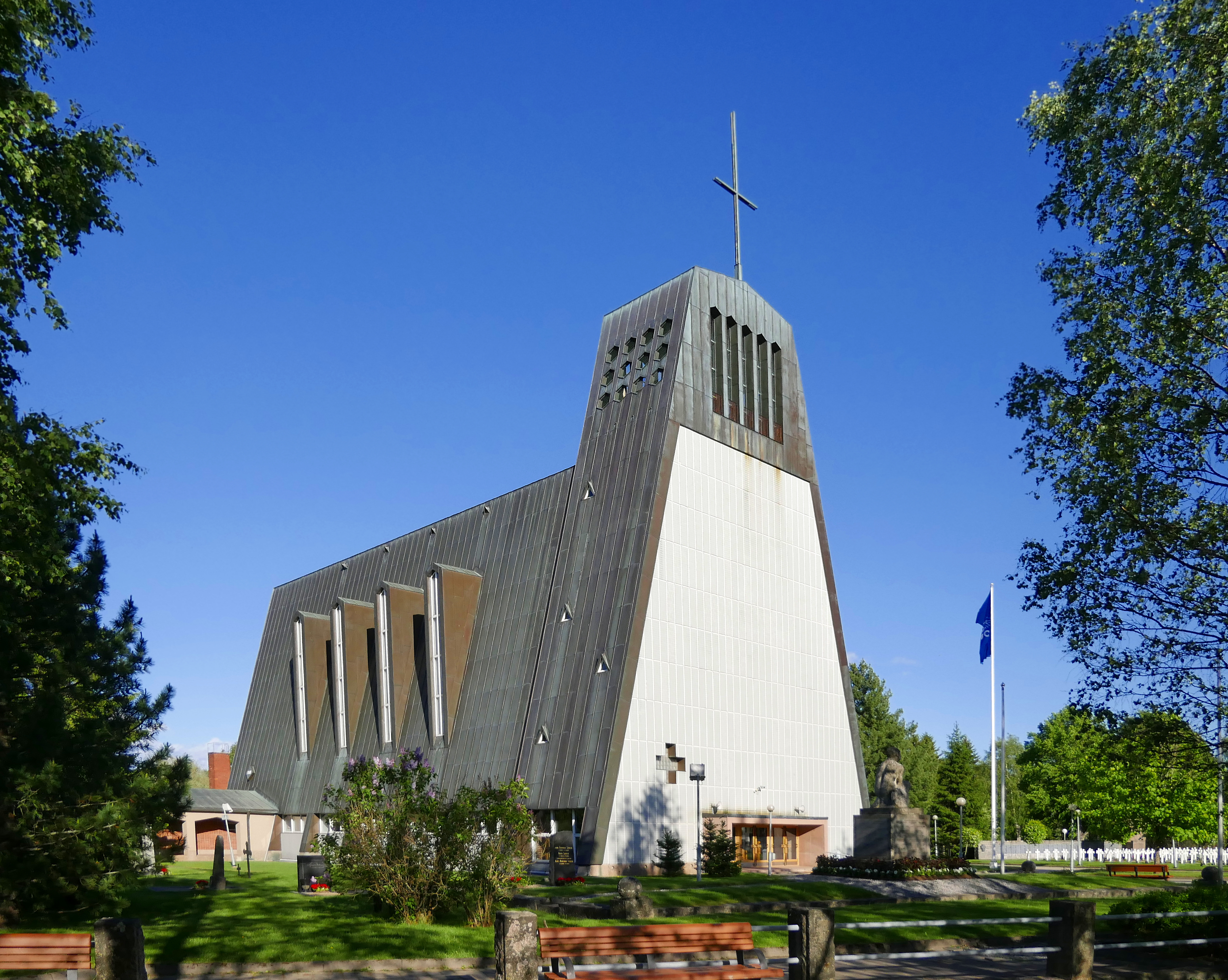
Niinisalo is a village in the municipality of Kankaanpää in the region of Satakunta in Finland. It is known for the Niinisalo Garrison which is the base of the Finnish Army unit Artillery Brigade (Finland), Artillery Brigade. The population of Niinisalo is 996 (2009). The Kankaanpää Museum is located in Niinisalo. From 1977 to 1997 Niinisalo was the home of the The Artillery Museum of Finland, Artillery Museum of Finland. Niinisalo railway station was designed by architect Thure Hellström in 1933 but the Pori–Haapamäki railway was closed in the 1980s. Niinisalo Garrison The Niinisalo Garrison was established in 1935. Since 1947 it has been the home of a field artillery unit, known since 1992 as the Artillery Regiment and later as the Artillery Brigade. At the beginning of 2015, the brigade was merged with the Pori Brigade. The United Nations Training Centre was organized in Niinisalo in 1969. It was a unit for training Finnish Peacekeeping, peacekeepers as well as intern ... [...More Info...] [...Related Items...] OR: [Wikipedia] [Google] [Baidu] |
Kauhajoki
Kauhajoki (; “Scoop River”) is a town and municipality of Finland. It is located in the province of Western Finland and is part of the Southern Ostrobothnia region, southwest of the city of Seinäjoki. The population of Kauhajoki is () and the municipality covers an area of of which is inland water (). The population density is . The town is unilingually Finnish. The neighboring municipalities of Kauhajoki are Isojoki in the southwest, Kankaanpää in the south, Karijoki in the west, Karvia in the southeast, Kurikka in the north and Teuva in the west. Kauhajoki is the center of the Suupohja sub-region. Geography Most of Kauhajoki is located north of the Suomenselkä's watershed. Most of the municipal area is a gently sloping plains to the west and north. On the border of the Kauhajoki and Isojoki is Lauhanvuori, one of the highest points in Western Finland, which rises 231 meters above sea level. However, the highest point of Lauhanvuori is on the Isojoki side ... [...More Info...] [...Related Items...] OR: [Wikipedia] [Google] [Baidu] |
Pori
Pori (; ; ) is a city in Finland and the regional capital of Satakunta. It is located on the west coast of the country, on the Gulf of Bothnia. The population of Pori is approximately , while the Pori sub-region, sub-region has a population of approximately . It is the most populous Municipalities of Finland, municipality in Finland, and the eighth most populous List of urban areas in Finland by population, urban area in the country. Pori is located some from the Gulf of Bothnia, on the estuary of the Kokemäki River, west of Tampere, north of Turku and north-west of Helsinki, the capital of Finland. Pori covers an area of of which is water. The population density is . Pori was established in 1558 by Duke John of Finland, Duke John, who later became King John III of Sweden. The municipality is unilingually Finnish. Pori was also once one of the main cities with Turku in the former Turku and Pori Province (1634–1997). The neighboring municipalities are Eurajoki, Kankaanp ... [...More Info...] [...Related Items...] OR: [Wikipedia] [Google] [Baidu] |
Honkajoki
Honkajoki (; ''Hongonjoki'' until 1952) is a List of former municipalities of Finland, former municipality of Finland. It was merged with the town of Kankaanpää on 1 January 2021. It was located in the provinces of Finland, province of Western Finland and was part of the Satakunta regions of Finland, region. The population of Honkajoki was 1,595 (31 December 2020) and the municipality covered an area of of which was inland water (1 January 2018). The population density was . The municipality was unilingually Finnish language, Finnish. References External links Municipality of Honkajoki – Official website Municipalities of Satakunta Populated places established in 1867 Populated places disestablished in 2021 1867 establishments in Finland {{WesternFinland-geo-stub ... [...More Info...] [...Related Items...] OR: [Wikipedia] [Google] [Baidu] |
Finland
Finland, officially the Republic of Finland, is a Nordic country in Northern Europe. It borders Sweden to the northwest, Norway to the north, and Russia to the east, with the Gulf of Bothnia to the west and the Gulf of Finland to the south, opposite Estonia. Finland has a population of 5.6 million. Its capital and largest city is Helsinki. The majority of the population are Finns, ethnic Finns. The official languages are Finnish language, Finnish and Swedish language, Swedish; 84.1 percent of the population speak the first as their mother tongue and 5.1 percent the latter. Finland's climate varies from humid continental climate, humid continental in the south to boreal climate, boreal in the north. The land cover is predominantly boreal forest biome, with List of lakes of Finland, more than 180,000 recorded lakes. Finland was first settled around 9000 BC after the Last Glacial Period, last Ice Age. During the Stone Age, various cultures emerged, distinguished by differen ... [...More Info...] [...Related Items...] OR: [Wikipedia] [Google] [Baidu] |
List Of Cities And Towns In Finland
The following is a list of cities and towns (, ) in Finland. The basic administrative unit of Finland is municipality. Since 1977, there is no legal difference between towns and municipalities, and a municipality can independently decide to call itself a city or town if it considers that it meets the requirements of an urban settlement. The following list includes the municipalities that use the word in their official name. For cities and towns founded before the 1960s, the list includes the year it was chartered. The names used in this encyclopedia are usually the Finnish or Swedish forms, depending on the majority language of the municipality, except when there is a commonly used English name. Cities (founded) See also * List of municipalities of Finland *List of urban areas in Finland by population Notes References External links * {{Europe topic, List of towns in, FI={{PAGENAME Finland Finland Finland, officially the Republic of Finland, ... [...More Info...] [...Related Items...] OR: [Wikipedia] [Google] [Baidu] |
Finland Under Swedish Rule
Finland was an integral part of Sweden from the Middle Ages until 1809. The starting point of Swedish rule is uncertain and controversial. It is traditionally linked to the First Swedish Crusade in the mid-12th century. Historical evidence of the establishment of Swedish rule in Finland exists from the middle of the 13th century onwards. Swedish rule ended in 1721 in most of so-called Old Finland, the south-eastern part of the Finnish territories, as a result of the Great Northern War. Sweden ceded the remainder of Old Finland in 1743, following the Russo-Swedish War (1741–43), Hats' War. Swedish rule over the rest of Finland ended on 17 September 1809, when the signing of the Treaty of Fredrikshamn, Treaty of Hamina ended the Finnish War. As a result, the eastern third of Sweden was ceded to the Russian Empire and became established as the autonomous Grand Duchy of Finland. Swedish rule in the area of modern-day Finland started as a result of the Northern Crusades. The Fin ... [...More Info...] [...Related Items...] OR: [Wikipedia] [Google] [Baidu] |
Hämeenkyrö
Hämeenkyrö (; ) is a municipalities of Finland, municipality of Finland. It is part of the Pirkanmaa regions of Finland, region, and is located from Tampere. The municipality has a population of () and covers an area of of which is water. The population density is . The neighboring municipalities of Hämeenkyrö are Ikaalinen, Nokia, Finland, Nokia, Sastamala and Ylöjärvi. The municipality is unilingually Finnish language, Finnish. The drinking horn depicting coat of arms of Hämeenkyrö was designed by Gustaf von Numers and it was confirmed in 1954. After the wars, the Evacuation of Finnish Karelia, evacuated Karelian population from Otradnoye, Priozersky District, Leningrad Oblast, Otradnoye (''Pyhäjärvi'') was mostly settled in Hämeenkyrö. Results of the 2021 Finnish municipal elections, resulted in the True Finns being the largest group on the Hämeenkyrö council, in Hämeenkyrö. The name Hämeenkyrö comes from Finnish words "Häme" and "kyrö", which togethe ... [...More Info...] [...Related Items...] OR: [Wikipedia] [Google] [Baidu] |
Military Cemetery
A war grave is a burial place for members of the armed forces or civilians who died during military campaigns or operations. Definition The term "war grave" does not only apply to graves: ships sunk during wartime are often considered to be war graves, as are military aircraft that crash into water; this is particularly true if crewmen perished inside the vehicle. Classification of a war grave is not limited to the occupier's death in combat but includes military personnel who die while in active service: for example, during the Crimean War, more military personnel died of disease than as a result of enemy action. A common difference between cemeteries of war graves and those of civilian peacetime graves is the uniformity of those interred. They generally died during a relatively short period, in a small geographic area and consist of service members from the few military units involved. When it comes to the two World Wars, the large number of casualties means that th ... [...More Info...] [...Related Items...] OR: [Wikipedia] [Google] [Baidu] |
Ostrobothnia (historical Province)
Ostrobothnia (; ) is a historical province comprising a large portion of western and northern Finland. Before the Treaty of Fredrikshamn in 1809, Ostrobothnia was part of Sweden. It is bounded by Karelia, Savonia (historical province), Savo, Tavastia (historical province), Tavastia (Häme) and Satakunta in the south, the Bothnian Sea, Bothnian Bay and Swedish Norrbotten in the west, Lapland in the north and Russia in the east. Etymology The word ''botten'' derives from Old Norse ''botn'', meaning 'bay'. It is Latinized as ''Bothnia''. The Finnish word ''pohja'' means either "north" or "bottom", and ''maa'' is "land". There are two possible explanations for the dual meaning of ''pohja''. The first is based on the ancient Scandinavian belief that the north was the bottom of the world, where the Sun disappeared each night. The second explanation points to the fact that houses were constructed with their backs to the north, the coldest direction, which may have given rise ... [...More Info...] [...Related Items...] OR: [Wikipedia] [Google] [Baidu] |


