|
Iowa Highway 21
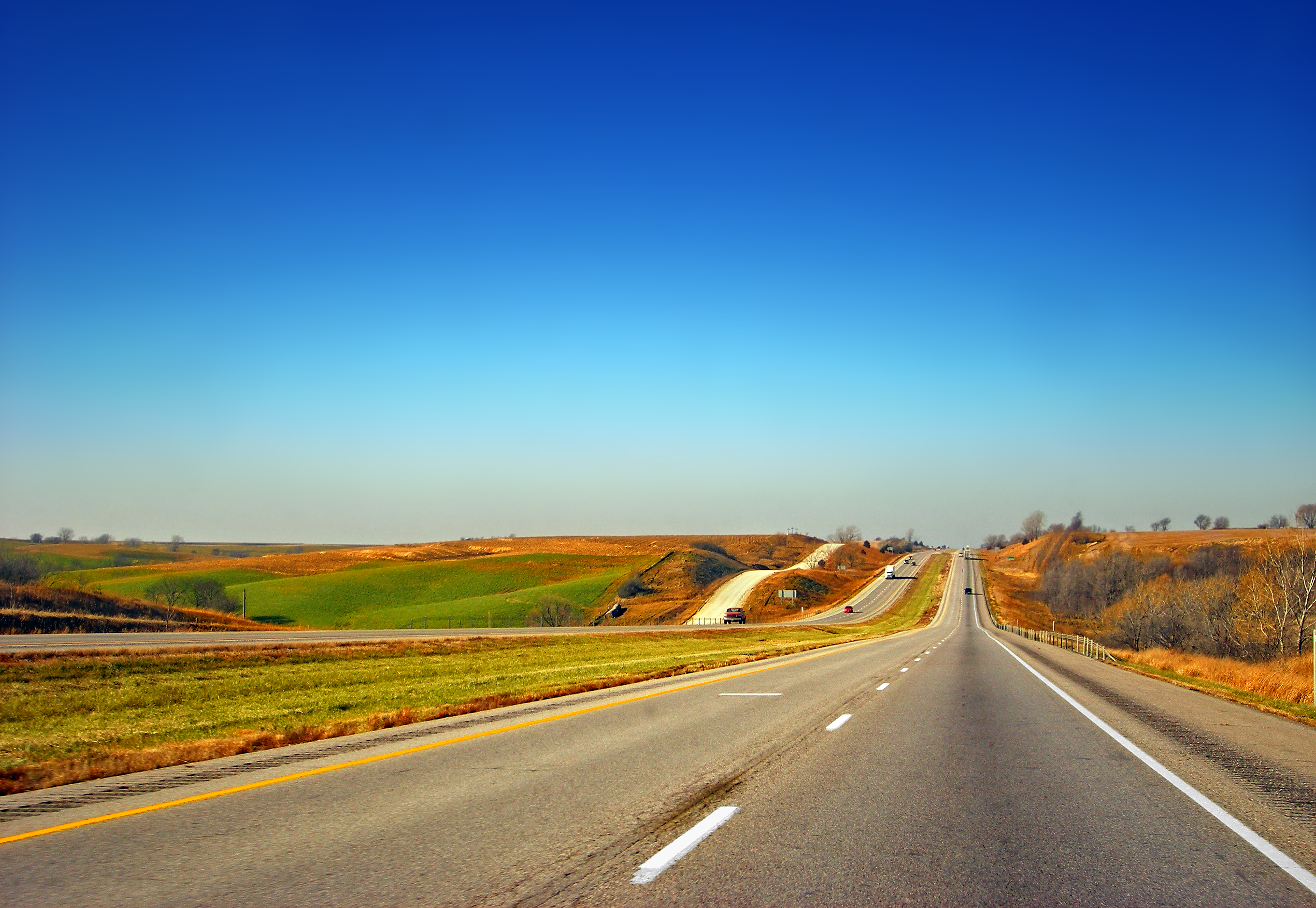
Iowa Highway 21 (Iowa 21) is a state highway that runs from north to south in central Iowa. It has a length of . Iowa 21 begins at Iowa 149 west of Hedrick and ends at a freeway interchange with U.S. Highway 20 (US 20) in Waterloo. Route description Iowa 21 begins one mile (1.6 km) west of Hedrick and goes north through Delta before intersecting Iowa 92. It proceeds through What Cheer before intersecting Iowa 22 west of Thornburg. It continues north to Deep River where it intersects Iowa 85. After passing through Guernsey, it then intersects Interstate 80, then meets US 6. It overlaps with U.S. 6 going eastward, then turns north near Victor. It then intersects Iowa 212 before entering Belle Plaine, then intersects US 30. It goes north to Dysart, where it turns west, overlapping with Iowa 8. It then turns north and ends at US 20 at the southern city limit of Waterloo. History The current ver ... [...More Info...] [...Related Items...] OR: [Wikipedia] [Google] [Baidu] |
Hedrick, Iowa
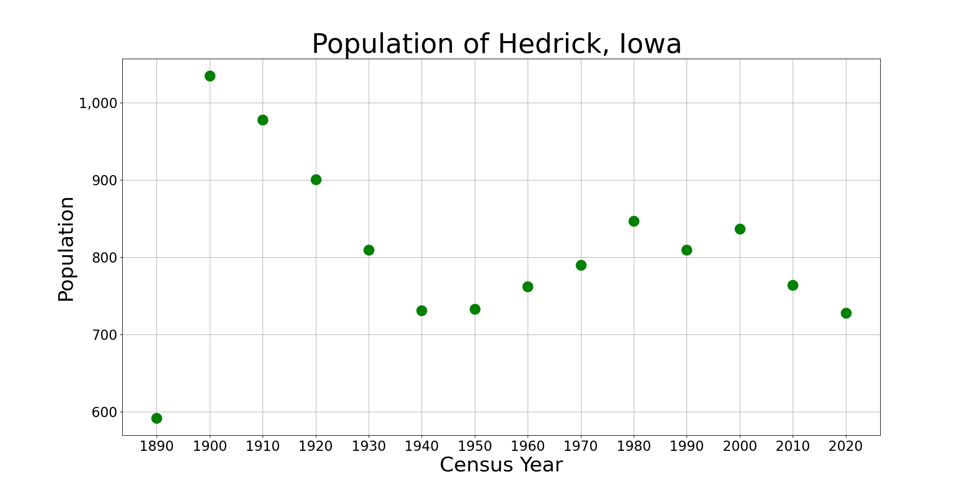
Hedrick is a city in Keokuk County, Iowa, United States. The population was 728 at the time of the 2020 census. History In 1882, the Burlington and Western Railway a narrow gauge line, and its competitor, the Iowa Central Railway, built competing east–west lines through the area. These crossed the Rock Island tracks here, so it was a natural location for a station and town.David Lotz and Charles Franzen, 'Rails to a County Seat', The Print Shop, Washington Iowa, 1989; pages 37, 47-52. Hedrick was incorporated on April 23, 1883. It was named for General Hedrick. The Burlington and Western was widened to standard gauge in 1902 and merged into the Chicago, Burlington and Quincy a year later. The Minneapolis and St. Louis took over the Iowa Central around the same time, and the Burlington line was abandoned in 1934. By 1991 several businesses in the community's main street closed, and the economy had declined. The school serving the town closed that year. In 2023, the city ... [...More Info...] [...Related Items...] OR: [Wikipedia] [Google] [Baidu] |
Iowa 92
Iowa Highway 92 (Iowa 92) is a state highway that runs from east to west across the state of Iowa. Iowa 92 is long. It begins at the Missouri River in Council Bluffs, where it is a continuation of Nebraska Highway 92. It stretches across the state and serves to roughly demarcate the southern one-third of Iowa. It ends at the Mississippi River in Muscatine where it continues into Illinois as Illinois Route 92. In 1939, Iowa 92 replaced the original Iowa 2 in its entirety. Route description Iowa 92 begins on the South Omaha Bridge above the Missouri River with U.S. Highway 275 (US 275) between Omaha, Nebraska, and Council Bluffs. It is a continuation of Nebraska Highway 92, which stretches across Nebraska and is itself a continuation of Wyoming Highway 92. Through Council Bluffs, the highways pass through the southern part of the city but just to the north of Lake Manawa. At an interchange with Interstate 29 (I-29), US 275 splits away from Io ... [...More Info...] [...Related Items...] OR: [Wikipedia] [Google] [Baidu] |
Ida Grove, Iowa
Ida Grove is a city in Ida County, Iowa, United States. The population was 2,051 at the time of the 2020 census. It is the county seat of Ida County. History Founded in 1871, the town now known as "Old Ida Grove" was located on the north side of the river. However, when the railroad was built through the neighborhood in 1877 on the south side, Ida Grove was relocated there. Ida Grove was incorporated on May 31, 1878, and was named for the county, which was named for Mount Ida, Greece. The Ida Grove post office contains an oil on linen mural, ''Preparation for the First County Fair in Ida Grove–1872'', painted by Andrene Kauffman in 1940. Federally commissioned murals were produced from 1934 to 1943 in the United States through the Section of Fine Arts, of the Treasury Department. Geography Ida Grove is located on US Route 59 and Iowa Highway 175 at the confluence of Odebolt Creek with Maple River. The Moorehead Pioneer Park and reservoir are located across the Maple Rive ... [...More Info...] [...Related Items...] OR: [Wikipedia] [Google] [Baidu] |
Iowa 8
Iowa Highway 8 is a state highway that runs from east to west in east central Iowa. Highway 8 is a short state highway in Iowa, at only long. Iowa 8 begins at an intersection with U.S. Highway 63 in Traer and ends at an intersection with U.S. Highway 218 northwest of Garrison. The route has largely remained the same since its designation. Route description Iowa 8 begins in downtown Traer at an intersection with US 63. As it exits the small community, it turns to the southeast and then again to the east, forming a long S curve. Through Tama County, the highway travels over a plain with farmland on either side of the road. west of Dysart, the road is intersected by Iowa 21, which joins Iowa 8 from the north. For the next , the two highways run together until they reach the eastern limits of Dysart, which is also the Tama–Benton county line. Now in Benton County, the Iowa 8 continues due east. The final of the route are much hillier than ... [...More Info...] [...Related Items...] OR: [Wikipedia] [Google] [Baidu] |
Belle Plaine, Iowa
Belle Plaine is a city in Benton County, Iowa, United States. The population was 2,330 at the 2020 United States Census, 2020 census. It is part of the Cedar Rapids, Iowa, Cedar Rapids Cedar Rapids metropolitan area, Metropolitan Statistical Area. History Belle Plaine was founded in 1862 when it was certain the railroad would be extended to that point. "Belle Plaine" is derived from the French meaning "beautiful plain". Belle Plaine is located on both the historic Lincoln Highway and the cross country tracks of the Union Pacific Railroad. Geography According to the United States Census Bureau, the city has a total area of , of which is land and is water. The Iowa River flows roughly southeastward, just south of the city airport. Demographics 2010 census As of the census of 2010, there were 2,534 people, 1,101 households, and 659 families living in the city. The population density was . There were 1,258 housing units at an average density of . The racial makeup of the city ... [...More Info...] [...Related Items...] OR: [Wikipedia] [Google] [Baidu] |
Iowa 212
Iowa Highway 212 is a state highway in Iowa County, Iowa. It runs from Iowa Highway 21 south of Belle Plaine to U.S. Highway 6 in Marengo. Iowa 212 was once a much longer highway, nearly , covering parts of the Lincoln Highway. Route description Iowa Highway 212 begins at an intersection with Iowa Highway 21 (Iowa 21) south of Belle Plaine. The intersection features a dominant curve from southbound Iowa 21 to eastbound Iowa 212. A short connector road allows westbound Iowa 212 traffic to reach southbound Iowa 21. Northbound Iowa 21 traffic must stop at the curve in order to continue north on Iowa 21. Heading east, Iowa 212 runs roughly parallel to the Iowa River for its entire length. It crosses Bear Creek before entering Marengo along South Street. At Western Avenue, Iowa 212 turns south towards U.S. Highway 6. Just from its eastern end, Iowa 212 crosses a single line of the Iowa Interstate Railroad. The route ends at US 6 on ... [...More Info...] [...Related Items...] OR: [Wikipedia] [Google] [Baidu] |
Interstate 80 In Iowa
Interstate 80 (I-80) is a transcontinental Interstate Highway in the United States, stretching from San Francisco, California, to Teaneck, New Jersey. In Iowa, the highway travels west to east through the center of the state. It enters the state at the Missouri River in Council Bluffs and heads east through the southern Iowa drift plain. In the Des Moines metropolitan area, I-80 meets up with I-35 and the two routes bypass Des Moines together. On the northern side of Des Moines, the Interstates split and I-80 continues east. In eastern Iowa, it provides access to the University of Iowa in Iowa City. Northwest of the Quad Cities in Walcott is Iowa 80, the world's largest truck stop. I-80 passes along the northern edge of Davenport and Bettendorf and leaves Iowa via the Fred Schwengel Memorial Bridge over the Mississippi River into Illinois. Before I-80 was planned, the route between Council Bluffs and Davenport, which passed through Des Moines, was vital to the sta ... [...More Info...] [...Related Items...] OR: [Wikipedia] [Google] [Baidu] |
Guernsey, Iowa
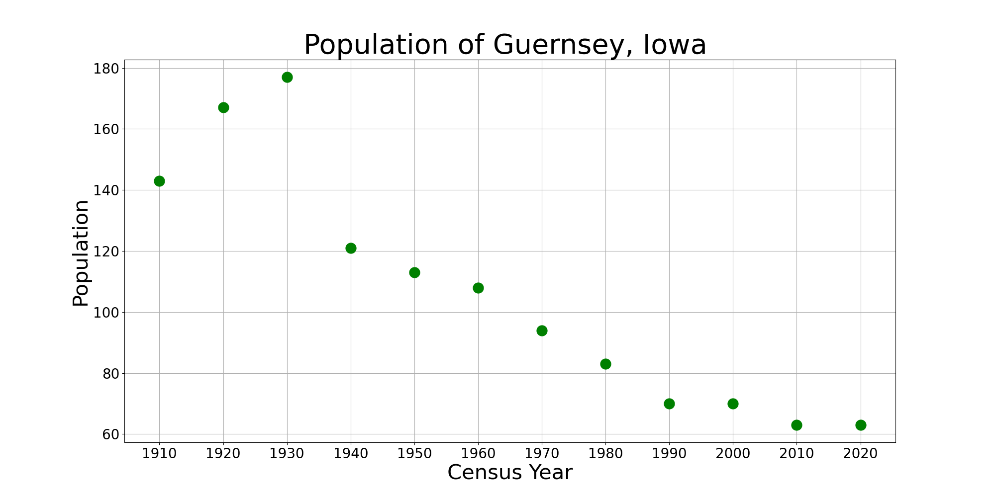
Guernsey is a town in Poweshiek County, Iowa, United States. The population was 63 at the time of the 2020 census. History Guernsey was platted in 1884. It was named after Guernsey County, Ohio. A post office was first established in Guernsey in 1884. Geography Guernsey is located at (41.650087, -92.344498). According to the United States Census Bureau, the town has a total area of , all land. Demographics 2010 census As of the census of 2010, there were 63 people, 27 households, and 18 families living in the town. The population density was . There were 32 housing units at an average density of . The racial makeup of the city was 96.8% White. Hispanic or Latino of any race were 3.2% of the population. There were 27 households, of which 22.2% had children under the age of 18 living with them, 55.6% were married couples living together, 11.1% had a female householder with no husband present, and 33.3% were non-families. 25.9% of all households were made up of individuals, ... [...More Info...] [...Related Items...] OR: [Wikipedia] [Google] [Baidu] |
Iowa 85
Iowa Highway 85 (Iowa 85) is a short state highway in east-central Iowa. The route begins at the eastern city limit of Montezuma and ends at Iowa 21 east of Deep River. Created in 1920 as a spur route connecting What Cheer to Primary Road No. 2, it is an original route in the Iowa primary highway system. In the early 1930s, the route was extended north to Deep River and west to Montezuma. By the end of the decade, Iowa 21 had taken over the north–south portion of the route. Except for both endpoints shifting slightly, Iowa 85 has largely stayed the same since the 1930s. Route description Iowa 85 begins at the eastern city limit of Montezuma. It heads east through the rolling farmland of Poweshiek County. Near the midpoint of the route, it intersects County Road V18 (CR V18). As it approaches Deep River, the route briefly curves to the north-northeast before turning to the southeast. The terrain becomes hillier as the route crosses a ... [...More Info...] [...Related Items...] OR: [Wikipedia] [Google] [Baidu] |
Deep River, Iowa
Deep River is a city in Poweshiek County, Iowa, United States. It is also the name of the township which includes the city. The city population was 249 at the time of the 2020 census. Geography Deep River is located at (41.580395, -92.374249). According to the United States Census Bureau, the city has a total area of , all land. Brief history and etymology In 1856 the town of Dresden, approximately one mile east of the present town of Deep River, was platted. The Whitney brothers operated a store there for about 20 years. When the Chicago and Northwestern Railroad was built, the residents of Dresden moved to be near the railroad, and thus the town of Deep River was established in 1884. The Dresden Cemetery lies about a mile and a half south of the current county road, locally known as the Diamond Trail, just about a quarter mile east of Iowa Highway 21. The town of Tilton was established at the southern border of the township in 1884 as well, although this largely lay in Keokuk ... [...More Info...] [...Related Items...] OR: [Wikipedia] [Google] [Baidu] |
Thornburg, Iowa
Thornburg is a village in Keokuk County, Iowa, Keokuk County, Iowa, United States. The population was 45 at the time of the 2020 United States Census, 2020 census. Its sole enterprise is the Tri-County Community School District (Iowa), Tri-County Community School, a public school serving grades K-12. History The Burlington, Cedar Rapids and Northern Railway built a 66-mile branch to What Cheer, Iowa, What Cheer via Thornburg in 1879. The town was founded by the railroad and named in memory of Major Thomas T. Thornburgh, who died in the Meeker Massacre. By 1881, Thornburg was at the junction of the line to What Cheer and a branch to Montezuma, Iowa, Montezuma. Geography According to the United States Census Bureau, the city has a total area of , all of it land. Demographics 2010 census At the 2010 United States Census, 2010 census there were 67 people, 27 households, and 20 families living in the city. The population density was . There were 29 housing units at an average den ... [...More Info...] [...Related Items...] OR: [Wikipedia] [Google] [Baidu] |
Iowa 22
Iowa Highway 22 (Iowa 22) is a west–east state highway that traverses primarily rural areas in east-central Iowa. The highway begins near Thornburg at an intersection with Iowa Highway 21 and ends in southwestern Davenport, at U.S. Highway 61 Business. Route description Iowa Highway 22 begins west of Thornburg at Iowa Highway 21. It continues east through Keswick and Webster. Between Webster and South English, Iowa 22 is overlapped with Iowa Highway 149. It continues east from South English through Kinross and Wellman before intersecting Iowa Highway 1 at Kalona. It proceeds east from Kalona to go through Riverside and then intersects U.S. Highway 218 and Iowa Highway 27. After crossing the Iowa River, it goes through Nichols, where a short overlap with Iowa Highway 70 begins. It then continues eastward and intersects U.S. Highway 61 at Muscatine. It goes around the west and north city limits of Muscatine before intersecting Iowa Highway 38 and Business US 61 and ... [...More Info...] [...Related Items...] OR: [Wikipedia] [Google] [Baidu] |


