|
Interstate 287
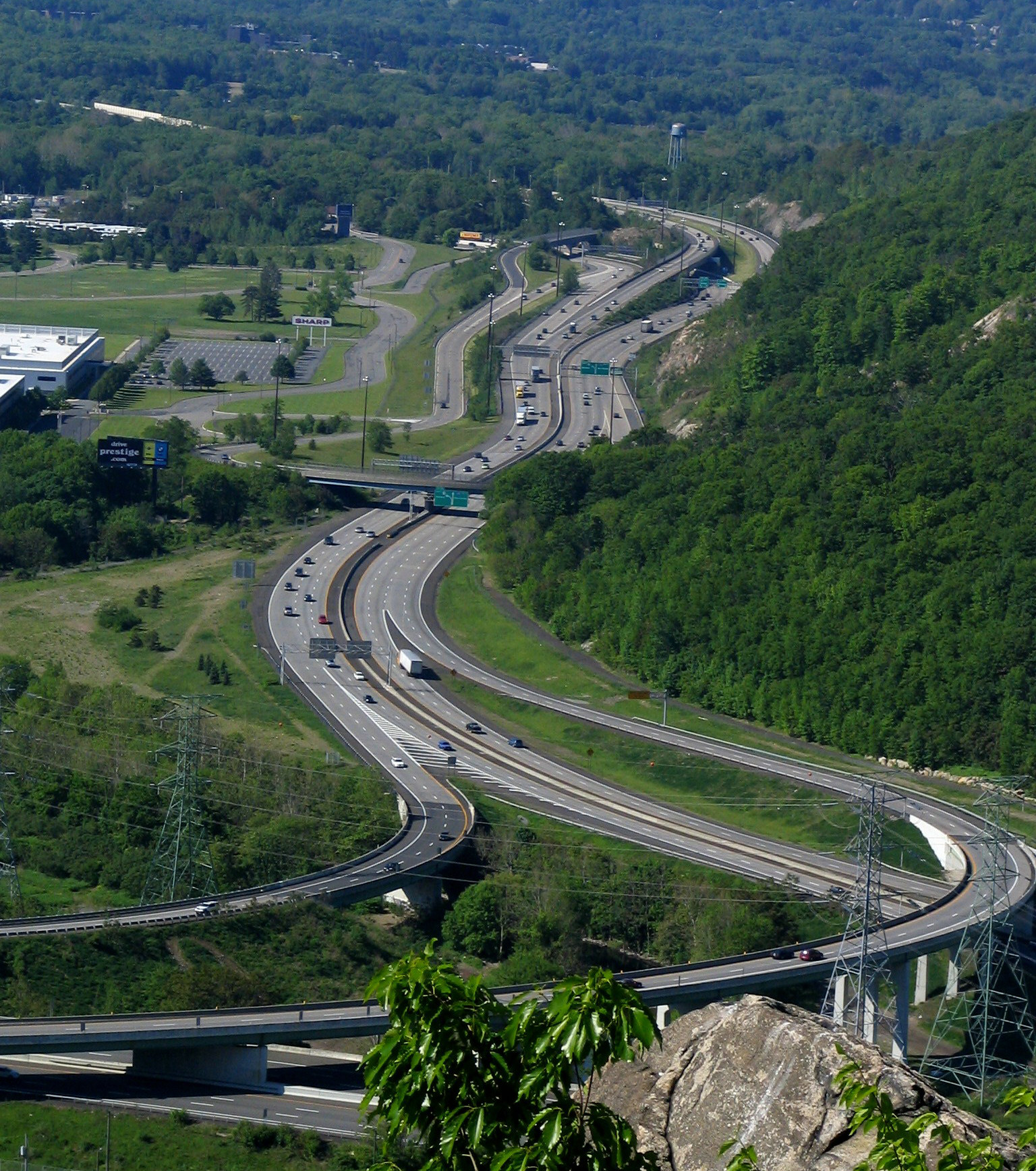
Interstate 287 (I-287) is an auxiliary Interstate Highway in the US states of New Jersey and New York. It is a partial beltway around New York City, serving the northern half of New Jersey and the counties of Rockland and Westchester in New York. I-287, which is signed north–south in New Jersey and east–west in New York, follows a roughly horseshoe-shaped route from the New Jersey Turnpike (I-95) in Edison, New Jersey, clockwise to the New England Thruway (I-95) in Rye, New York, for . Through New Jersey, I-287 runs west from its southern terminus in Edison through suburban areas. In Bridgewater Township, the freeway takes a more northeasterly course, paralleled by US Route 202 (US 202). The northernmost part of I-287 in New Jersey passes through mountainous surroundings. After crossing into New York at Suffern, I-287 turns east on the New York State Thruway (I-87) and runs through Rockland County. After crossing the Hudson River on the Tappan Zee Bridge, ... [...More Info...] [...Related Items...] OR: [Wikipedia] [Google] [Baidu] |
New Jersey Department Of Transportation
The New Jersey Department of Transportation (NJDOT) is the agency responsible for transportation issues and policy in New Jersey, including maintaining and operating the state's highway and public road system, planning and developing transportation policy, and assisting with rail, freight, and intermodal transportation issues. It is headed by the Commissioner of Transportation. The present Commissioner is Diane Gutierrez-Scaccetti. History The agency that became NJDOT began as the New Jersey State Highway Department (NJSHD) circa 1920. NJDOT was established in 1966 as the first State transportation agency in the United States. The Transportation Act of 1966 (Chapter 301, Public Laws, 1966) established the NJDOT on December 12, 1966. Since the late 1970s, NJDOT has been phasing out or modifying many list of traffic circles in New Jersey, traffic circles in New Jersey. In 1979, with the establishment of New Jersey Transit, NJDOT's rail division, which funded and supported State-s ... [...More Info...] [...Related Items...] OR: [Wikipedia] [Google] [Baidu] |
Somerset County, New Jersey
Somerset County is a county located in the north-central part of the U.S. state of New Jersey. As of the 2020 United States Census, the county's population was 345,361, an increase of 21,917 (6.8%) from the 323,444 counted at the 2010 U.S Census, making it the 13th most populous of the state's 21 counties. Somerset County constitutes part of the New York Metropolitan Area. Its county seat is Somerville.New Jersey County Map . Accessed July 10, 2017. The most populous place in the county was [...More Info...] [...Related Items...] OR: [Wikipedia] [Google] [Baidu] |
Rye, New York
Rye is a coastal suburb of New York City in Westchester County, New York, United States. It is separate from the Town of Rye, which has more land area than the city. The City of Rye, formerly the Village of Rye, was part of the Town until it received its charter as a city in 1942, making it the youngest city in the State of New York. Its population density for its 5.85 square miles of land is roughly 2,729.76/sq mi. Rye is notable for its waterfront which covers 60 percent of the city's six square miles and is governed by a waterfront act instituted in 1991. Located in the city are two National Historic Landmarks: the Boston Post Road Historic District was designated a National Historic Landmark by the National Park Service in 1993; its centerpiece is the Jay Estate, the childhood home of John Jay, a Founding Father and the first Chief Justice of the United States. Playland, a historic amusement park designated a National Historic Landmark in 1987 is also located in Rye. P ... [...More Info...] [...Related Items...] OR: [Wikipedia] [Google] [Baidu] |
Interstate 95 In New York
Interstate 95 (I-95) is part of the Interstate Highway System and runs from Miami, Florida, to the Canada–United States border near Houlton, Maine. In the U.S. state of New York, I-95 extends from the George Washington Bridge in New York City to the Connecticut state line at Port Chester. The George Washington Bridge carries I-95 across the Hudson River from New Jersey into New York City. There, I-95 runs across upper Manhattan on the Trans-Manhattan Expressway for through Washington Heights. It continues east across the Harlem River on the Alexander Hamilton Bridge and onto the Cross Bronx Expressway. In the Bronx, I-95 leaves the Cross Bronx at the Bruckner Interchange, joining the Bruckner Expressway to its end. North of the interchange with Pelham Parkway, it then continues northeast via the New England Thruway (which is part of the New York State Thruway system) out of New York City into Westchester County and to the Connecticut state line, where I-95 continues ... [...More Info...] [...Related Items...] OR: [Wikipedia] [Google] [Baidu] |
New England Thruway
Interstate 95 (I-95) is part of the Interstate Highway System and runs from Miami, Florida, to the Canada–United States border near Houlton, Maine. In the U.S. state of New York, I-95 extends from the George Washington Bridge in New York City to the Connecticut state line at Port Chester. The George Washington Bridge carries I-95 across the Hudson River from New Jersey into New York City. There, I-95 runs across upper Manhattan on the Trans-Manhattan Expressway for through Washington Heights. It continues east across the Harlem River on the Alexander Hamilton Bridge and onto the Cross Bronx Expressway. In the Bronx, I-95 leaves the Cross Bronx at the Bruckner Interchange, joining the Bruckner Expressway to its end. North of the interchange with Pelham Parkway, it then continues northeast via the New England Thruway (which is part of the New York State Thruway system) out of New York City into Westchester County and to the Connecticut state line, where I-95 continues ... [...More Info...] [...Related Items...] OR: [Wikipedia] [Google] [Baidu] |
Interstate 95 In New Jersey
Interstate 95 (I-95) is a major Interstate Highway that traverses nearly the full extent of the East Coast of the United States, from Florida to Maine. In the state of New Jersey, it runs along much of the mainline of the New Jersey Turnpike (exit 6 to exit 18), as well as the Pearl Harbor Memorial Extension (formerly and still commonly known as the Pennsylvania Turnpike Connector; from exit 6 to the Delaware River–Turnpike Toll Bridge), and the New Jersey Turnpike's I-95 Extension (from exit 18) to the George Washington Bridge for a total of . Located in the northeastern part of the state near New York City, the Western Spur of the New Jersey Turnpike, considered to be Route 95W by the New Jersey Department of Transportation (NJDOT), is also part of I-95. I-95 enters the state from the Pennsylvania Turnpike on the Delaware River–Turnpike Toll Bridge, following the length of the Pearl Harbor Memorial Extension to exit 6 on the New Jersey Turnpike mainline, continuing nort ... [...More Info...] [...Related Items...] OR: [Wikipedia] [Google] [Baidu] |
New Jersey Turnpike
The New Jersey Turnpike (NJTP) is a system of controlled-access highways in the U.S. state of New Jersey. The turnpike is maintained by the New Jersey Turnpike Authority (NJTA).The Garden State Parkway, although maintained by NJTA, is not considered part of the turnpike. The mainline's southern terminus is at a complex interchange with Interstate 295 (Delaware–Pennsylvania), Interstate 295 (I-295), U.S. Route 40 in New Jersey, U.S. Route 40 (US 40), U.S. Route 130, US 130, and New Jersey Route 49, Route 49 near the border of Pennsville Township, New Jersey, Pennsville and Carneys Point Township, New Jersey, Carneys Point townships in Salem County, New Jersey, Salem County, east of the Delaware Memorial Bridge. Its original northern terminus was at an interchange with Interstate 80 in New Jersey , I-80 and U.S. Route 46, US 46 in Ridgefield Park, New Jersey, Ridgefield Park, Bergen County, New Jersey, Bergen County; the turnpike was later extended to t ... [...More Info...] [...Related Items...] OR: [Wikipedia] [Google] [Baidu] |
New York City
New York, often called New York City or NYC, is the List of United States cities by population, most populous city in the United States. With a 2020 population of 8,804,190 distributed over , New York City is also the List of United States cities by population density, most densely populated major city in the United States, and is more than twice as populous as second-place Los Angeles. New York City lies at the southern tip of New York (state), New York State, and constitutes the geographical and demographic center of both the Northeast megalopolis and the New York metropolitan area, the largest metropolitan area in the world by urban area, urban landmass. With over 20.1 million people in its metropolitan statistical area and 23.5 million in its combined statistical area as of 2020, New York is one of the world's most populous Megacity, megacities, and over 58 million people live within of the city. New York City is a global city, global Culture of New ... [...More Info...] [...Related Items...] OR: [Wikipedia] [Google] [Baidu] |
Beltway
A ring road (also known as circular road, beltline, beltway, circumferential (high)way, loop, bypass or orbital) is a road or a series of connected roads encircling a town, city, or country. The most common purpose of a ring road is to assist in reducing traffic volumes in the urban centre, such as by offering an alternate route around the city for drivers who do not need to stop in the city core. Ring roads can also serve to connect suburbs to each other, allowing efficient travel between them. Nomenclature The name "ring road" is used for the majority of metropolitan circumferential routes in Europe, such as the Berliner Ring, the Brussels Ring, the Amsterdam Ring, the Boulevard Périphérique around Paris and the Leeds Inner and Outer ring roads. Australia, Pakistan and India also use the term ring road, as in Melbourne's Western Ring Road, Lahore's Lahore Ring Road and Hyderabad's Outer Ring Road. In Canada the term is the most commonly used, with "orbital" also used, ... [...More Info...] [...Related Items...] OR: [Wikipedia] [Google] [Baidu] |
Auxiliary Interstate Highway
Auxiliary Interstate Highways (also called three-digit Interstate Highways) are a supplemental subset of the freeways within the Interstate Highway System of the United States. Auxiliary routes are generally classified as spur routes, which connect to the parent route at one end, bypasses, which connect to the parent route at both ends, or beltways, which form a complete circle intersecting the parent route at two locations. There are 323 auxiliary Interstates in the United States. There are some routes which connect to the parent route at one end, but connect to another route at the other end; some states treat these as spurs while others treat them as bypasses. Similar to the mainline Interstate Highways, these highways also meet all Interstate Highway standards (with rare exceptions), and they receive the same percentage of federal funding (90%). The shorter auxiliary routes branch off main routes and are numbered based on the number of the parent route. All of the supple ... [...More Info...] [...Related Items...] OR: [Wikipedia] [Google] [Baidu] |
Westchester County, New York
Westchester County is located in the U.S. state of New York. It is the seventh most populous county in the State of New York and the most populous north of New York City. According to the 2020 United States Census, the county had a population of 1,004,456, an increase of 55,344 (5.8%) from the 949,113 counted in 2010. Located in the Hudson Valley, Westchester covers an area of , consisting of six cities, 19 towns, and 23 villages. Established in 1683, Westchester was named after the city of Chester, England. The county seat is the city of White Plains, while the most populous municipality in the county is the city of Yonkers, with 211,569 residents per the 2020 U.S. Census. The annual per capita income for Westchester was $67,813 in 2011. The 2011 median household income of $77,006 was the fifth-highest in New York (after Nassau, Putnam, Suffolk, and Rockland counties) and the 47th highest in the United States. By 2014, the county's median household income had risen to $83, ... [...More Info...] [...Related Items...] OR: [Wikipedia] [Google] [Baidu] |
Rockland County, New York
Rockland County is the southernmost county on the west side of the Hudson River in the U.S. state of New York. It is part of the New York metropolitan area. It is about from the Bronx at their closest points. The county's population, as of the 2020 United States Census, is 338,329, making it the state's third-most densely populated county outside New York City (after Nassau and neighboring Westchester Counties, respectively). The county seat is New City. Rockland County is accessible via the New York State Thruway, which crosses the Hudson to Westchester at the Tappan Zee Bridge ten exits up from the NYC border, as well as the Palisades Parkway five exits up from the George Washington Bridge. The county's name derives from "rocky land", as the area has been aptly described, largely due to the Hudson River Palisades. This county is home to one of the most prominent towns in American history. Congers, NY is home to the stepping grounds of Commander-In-Chief George Washing ... [...More Info...] [...Related Items...] OR: [Wikipedia] [Google] [Baidu] |


