|
Irstead
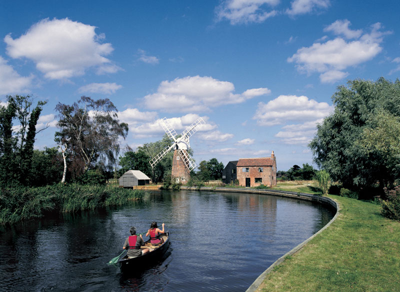
Irstead is a village and former civil parish, now in the parish of Barton Turf, in the English county of Norfolk. Irstead is located north of Acle and north-east of Norwich, along the River Ant. History Irstead's name is of Anglo-Saxon origin and derives from the Old English for mud place. Irstead is not listed in the Domesday Book. On 1 April 1935 the parish was abolished and merged with Barton Turf. Geography In 1931 the parish had a population of 113, this was the last time that separate population statistics were collected for Irstead as in 1935 the parish was merged. St. Michael's Church Irstead's church is dedicated to Saint Michael and dates from the Fourteenth Century. St. Michael's is located on Irstead Road and has been Grade II listed since 1955. The church is open sporadically for Sunday service. St. Michael's features a carved font and a painted rood screen, which are both medieval survivals. The church also holds a wall painting of Saint Christophe ... [...More Info...] [...Related Items...] OR: [Wikipedia] [Google] [Baidu] |
River Ant
The River Ant is a tributary river of the River Bure in the county of Norfolk, England. It is long (of which 8.75 miles are now navigable), and has an overall drop of 27 metres from source to mouth. It is said that the Ant was formerly known as the River Smalea and that this is the origin of the name of the village of Smallburgh. The modern name is a back-formation from Antingham. The Ant Broads & Marshes NNR is a national nature reserve. From source to Honing The river's source is just east of the village of Antingham in North Norfolk at Antingham Ponds. Just below the pools the river's route has been used as a canal in the past, starting at what was Antingham bone mill. An Act of Parliament established the North Walsham and Dilham Canal in 1812, as a wide gauge canal able to take a Norfolk wherry. It was built at a cost of £30,000 and opened on 25 July 1826, making the river navigable as far as Dilham, where the river widens and deepens. It carried manure, offal, f ... [...More Info...] [...Related Items...] OR: [Wikipedia] [Google] [Baidu] |
Barton Turf
Barton Turf is a village and civil parish in the English county of Norfolk. It is 20 km north-east of the city of Norwich, on the northwestern edge of Barton Broad, the second largest of the Norfolk Broads. In primary local government the area is in the district of North Norfolk. The villages name means 'Barley farm/settlement'. 'Turf' is a late 14th century addition, probably indicating that turf cutting was an important local industry. The civil parish, which includes the whole of Barton Broad and the smaller village of Irstead at its southern end, has an area of 10.86 km2. In the 2001 census it had a population of 480 in 181 households, the population decreasing to 467 at the 2011 Census. Barton Turf's St Michael and All Angels Church, Barton Turf, about a mile from the clustered village centre, has a large, ornate medieval painted rood screen such as many medieval parishes who could afford fine artisans once had, but which have rarely survived the English Re ... [...More Info...] [...Related Items...] OR: [Wikipedia] [Google] [Baidu] |
North Norfolk
North Norfolk is a Non-metropolitan district, local government district in Norfolk, England. Its council is based in Cromer, and the largest town is North Walsham. The district also includes the towns of Fakenham, Holt, Norfolk, Holt, Sheringham, Stalham and Wells-next-the-Sea, along with numerous villages and surrounding rural areas. The district lies on the north coast of Norfolk, facing the North Sea, with much of its coastline lying within the Norfolk Coast AONB, Norfolk Coast Area of Outstanding Natural Beauty. Some south-eastern parts of the district lie within The Broads. The neighbouring districts are Borough of Great Yarmouth, Great Yarmouth, Breckland District, Breckland, Broadland and King's Lynn and West Norfolk. History The district was created on 1 April 1974 under the Local Government Act 1972, covering seven former districts which were all abolished at the same time: *Cromer Urban district (England and Wales), Urban District *Erpingham Rural District *North Wa ... [...More Info...] [...Related Items...] OR: [Wikipedia] [Google] [Baidu] |
Non-metropolitan District
Non-metropolitan districts, or colloquially "shire districts", are a type of Districts of England, local government district in England. As created, they are sub-divisions of non-metropolitan county, non-metropolitan counties (colloquially ''shire counties'') in a two-tier arrangement. Non-metropolitan districts with Borough status in the United Kingdom, borough status are known as ''boroughs'', able to appoint a Mayors in England, mayor and refer to itself as a borough council. Some shire counties, for example Cornwall, now have no sub-divisions so are a single non-metropolitan district. Typically, a district will consist of a market town and its more rural hinterland. However, districts are diverse, with some being mostly urban (such as Dartford) and others more polycentric (such as Thurrock). Structure Non-metropolitan districts are subdivisions of English non-metropolitan county, non-metropolitan counties which have a two-tier structure of local government. Two-tier non-m ... [...More Info...] [...Related Items...] OR: [Wikipedia] [Google] [Baidu] |
Pozières Memorial
The Pozières Memorial is a World War I war memorial, memorial, located near the commune of Pozières, in the Somme (department), Somme department of France, and unveiled in August 1930. It lists the names of 14,657 British and South African soldiers of the Fifth Army (United Kingdom), Fifth and Fourth Army (United Kingdom), Fourth Armies with no known grave who were killed between 21 March 1918 and 7 August 1918, during the German advance known as the German spring offensive, Spring Offensive (21 March–18 July), and the period of Allied consolidation and recovery that followed. The final date is determined by the start of the period known as the Advance to Victory on 8 August. The memorial forms the perimeter walls of a Commonwealth War Graves Commission cemetery, which principally contains the bodies of men killed during the Battle of Pozières and the Battle of the Somme in 1916. Memorial The memorial commemorates the missing of the British Fifth Army (United Kingdom), Fif ... [...More Info...] [...Related Items...] OR: [Wikipedia] [Google] [Baidu] |
Sherwood Foresters
The Sherwood Foresters (Nottinghamshire and Derbyshire Regiment) was a line infantry regiment of the British Army in existence for just under 90 years, from 1881 to 1970. In 1970, the regiment was amalgamated with the Worcestershire Regiment to form the Worcestershire and Sherwood Foresters Regiment, which in 2007 was amalgamated with the Cheshire Regiment and the Staffordshire Regiment (Prince of Wales's) to form the present Mercian Regiment. The lineage of the Sherwood Foresters is now continued by The Mercian Regiment. History Pre 1914 history The regiment was formed on 1 July 1881 as part of the Childers Reforms. The 45th (Nottinghamshire) Regiment of Foot (raised in 1741) and the 95th (Derbyshire) Regiment of Foot (raised in 1823) were redesignated as the 1st and 2nd battalions of the Sherwood Foresters (Derbyshire Regiment). The Derbyshire Militia and Royal Sherwood Foresters Militia became the 3rd (Reserve) and 4th (Extra Reserve) battalions respectively. These were j ... [...More Info...] [...Related Items...] OR: [Wikipedia] [Google] [Baidu] |
Courcelles-le-Comte
Courcelles-le-Comte (; ) is a commune in the department of Pas-de-Calais, France. Geography Courcelles-le-Comte is located 11 miles (17 km) south of Arras at the junction of the D12 and D32 roads. Population Places of interest * The church of St.Sulpice, rebuilt, as was most of the village, after the ravages of World War I. * The Commonwealth War Graves Commission cemetery. * Remains of an old castle. See also *Communes of the Pas-de-Calais department The following is a list of the 887 communes of the Pas-de-Calais department of France. The communes cooperate in the following intercommunalities (as of 2025): References External links An unofficial website of the commune [...More Info...] [...Related Items...] OR: [Wikipedia] [Google] [Baidu] |
King's Regiment (Liverpool)
The King's Regiment (Liverpool) was one of the oldest line infantry regiments of the British Army, having been formed in 1685 when a single battalion was raised as The Anne, Queen of Great Britain, Princess Anne of Denmark's Regiment of Foot. The original uniform consisted of a long Scarlet (color), scarlet coat turned up with yellow. Yellow breeches and waistcoat, white cravat, broad brimmed hat turned up and adorned with yellow ribbon, white stockings and 'serviceable' shoes. In 1702 when she succeeded the throne as Queen Anne, the sovereign ordered the title to be altered to The Queen's Regiment. In 1751, when all British Army infantry regiments were numbered, the title became; 8th or The King's Regiment after the then monarch George II of Great Britain, King George II, and was from then onward referred to as 8th Foot, 8th Regiment or 8th King's. Unlike most British Army infantry regiments, which were associated with a county, the King's represented the city of Liverpool, ... [...More Info...] [...Related Items...] OR: [Wikipedia] [Google] [Baidu] |
Menin Gate
The Menin Gate (), officially the Menin Gate Memorial to the Missing, is a war memorial in Ypres, Belgium, dedicated to the British and Commonwealth soldiers who were killed in the Ypres Salient of World War I and whose graves are unknown. The memorial is located at the eastern exit of the town and marks the starting point for one of the main roads that led Allied soldiers to the front line. Designed by Sir Reginald Blomfield and built by the Imperial War Graves Commission (since renamed the Commonwealth War Graves Commission), the Menin Gate Memorial was unveiled on 24 July 1927. In early 2023, the monument was closed for extensive restoration works, expected to be completed in time for the memorial's centenary in 2027. Background In medieval times, the original narrow gateway on the eastern wall of Ypres was called the Hangoartpoort, "poort" being the Dutch word for gate. During the 17th and 18th centuries, while under the occupation of the Habsburgs and the French, the ci ... [...More Info...] [...Related Items...] OR: [Wikipedia] [Google] [Baidu] |
Coldstream Guards
The Coldstream Guards is the oldest continuously serving regular regiment in the British Army. As part of the Household Division, one of its principal roles is the protection of the Monarchy of the United Kingdom, monarchy; due to this, it often participates in state ceremonial occasions. The Regiment has consistently provided formations on deployments around the world and has fought in the majority of the major conflicts in which the British Army has been engaged. The Regiment has been in continuous service and has never been amalgamated. It was formed in 1650 as 'Monck's Regiment of Foot' and was then renamed the 'Lord General's Regiment of Foot Guards' after the Stuart Restoration, Restoration in 1660. With George Monck, 1st Duke of Albemarle, George Monck's death in 1670 it was again renamed the 'Coldstream Regiment of Foot Guards' after Coldstream, the location in Scotland from which it marched to help restore the monarchy in 1660. Its name was again changed to the 'Coldstre ... [...More Info...] [...Related Items...] OR: [Wikipedia] [Google] [Baidu] |
Thiepval Memorial
The Thiepval Memorial to the Missing of the Somme is a war memorial to 72,337 missing British and South African servicemen who died in the Battles of the Somme of the First World War between 1915 and 1918, with no known grave. It is near the village of Thiepval, Picardy in France. A visitors' centre opened in 2004. Designed by Sir Edwin Lutyens, Thiepval has been described as "the greatest executed British work of monumental architecture of the twentieth century". Location The Memorial was built approximately to the south-east of the former Thiepval Château, which was located on lower ground, by the side of Thiepval Wood. The grounds of the original château were not chosen as this would have required the moving of graves, dug during the war around the numerous medical aid stations. Design and inauguration Designed by Sir Edwin Lutyens, the memorial was built between 1928 and 1932 and is the largest Commonwealth Memorial to the Missing in the world. It was inaugurated by ... [...More Info...] [...Related Items...] OR: [Wikipedia] [Google] [Baidu] |
Border Regiment
The Border Regiment was a line infantry regiment of the British Army, which was formed in 1881 under the Childers Reforms by the amalgamation of the 34th (Cumberland) Regiment of Foot and the 55th (Westmorland) Regiment of Foot. After service in the Second Boer War, followed by both World War I and World War II, the regiment was amalgamated with the King's Own Royal Regiment (Lancaster) into the King's Own Royal Border Regiment in 1959, which was later merged with the King's Regiment, King's Regiment (Liverpool and Manchester) and the Queen's Lancashire Regiment to form the present Duke of Lancaster's Regiment, Duke of Lancaster's Regiment (King's, Lancashire and Border), which continues the lineage of the Border Regiment. History 1881–1914 The regiment was formed on 1 July 1881 as part of the Childers Reforms by the amalgamation of the 34th (Cumberland) Regiment of Foot and the 55th (Westmorland) Regiment of Foot. Under the reforms, each line infantry regiment was to have a d ... [...More Info...] [...Related Items...] OR: [Wikipedia] [Google] [Baidu] |


