|
Hirschaid
Hirschaid is a German market town in the Upper Franconian district of Bamberg and lies roughly twelve kilometres south of Bamberg on the Regnitz and the Main-Danube Canal. Geography Location The community's main centre lies south-southeast of Bamberg where the Reiche Ebrach empties into the Regnitz. For various reasons, among them the community's favourable location on the A 73 and its close proximity to Bamberg (12 km), Forchheim (13 km), Erlangen (about 30 km), Fürth (about 40 km) and Nuremberg (about 50 km), Hirschaid has grown markedly since the 1960s. Constituent communities Hirschaid's main and namesake centre is by far the biggest of its ''Gemeindeteile'' with a population of 6,080. The community furthermore has these outlying centres, each given here with its own population figure (as of 2019): * Erlach 445 * Friesen bei Hirschaid 377 * Großbuchfeld 126 * Juliushof 552 * Kleinbuchfeld 135 * Köttmannsdorf bei Hirschaid 641 * Röbersdorf 826 ... [...More Info...] [...Related Items...] OR: [Wikipedia] [Google] [Baidu] |
Erlach (Hirschaid)
Erlach is a small village located in Bavaria, Germany. It is in Upper Franconia, in the Bamberg district. Erlach is a constituent community of Hirschaid. In 2019, the village had a population of 445. Geography Erlach lies about 12 kilometers south of Bamberg. A stream called the Reiche Ebrach flows through the village. The Rhine–Main–Danube Canal is east of the village.Google Maps Accessed September 24, 2010. History The town was first mentioned in 1062 as ''Sconen erlaha'' ("the beautiful Erlach").[...More Info...] [...Related Items...] OR: [Wikipedia] [Google] [Baidu] |
Bamberg (district)
Bamberg () is a ''Landkreis'' (district) in Bavaria, Germany. It surrounds but does not include the town of Bamberg. The district is bounded by the districts of (from the north and clockwise) Lichtenfels, Bayreuth, Forchheim, Erlangen-Höchstadt, Neustadt (Aisch)-Bad Windsheim, Kitzingen, Schweinfurt and Haßberge. History The history of the district is linked with the history of Bamberg. In 1862 the districts of Bamberg-West and Bamberg-East were established. They were merged in 1929. The present borders were established in 1972, when portions of the adjoining district of Erlangen-Höchstadt were annexed. Geography The district surrounds the town of Bamberg. The western half of the district is occupied by the Steigerwald, a hilly forest region. In the east there is the hill chain of the Franconian Jura The Franconian Jura ( , , or ) is an upland in Franconia, Bavaria, Germany. Located between two rivers, the Danube in the south and the Main in the north, its peaks ... [...More Info...] [...Related Items...] OR: [Wikipedia] [Google] [Baidu] |
Bundesautobahn 73
is a motorway in Germany. It connects Suhl to Nuremberg Nuremberg ( ; german: link=no, Nürnberg ; in the local East Franconian dialect: ''Nämberch'' ) is the second-largest city of the German state of Bavaria after its capital Munich, and its 518,370 (2019) inhabitants make it the 14th-largest .... The part between Bamberg and Nuremberg is also known as the Frankenschnellweg. Between exits Nürnberg/Fürth and Nürnberg-Hafen Ost it is not classified as Bundesautobahn. In Nürnberg-Gostenhof it is not an Autobahn and interrupted by crossings with traffic lights. Exit list External links 073 A073 A073 Buildings and structures in Nürnberger Land {{Germany-road-stub ... [...More Info...] [...Related Items...] OR: [Wikipedia] [Google] [Baidu] |
Bayerisches Landesamt Für Statistik ...
The statistical offices of the German states ( German: ''Statistische Landesämter'') carry out the task of collecting official statistics in Germany together and in cooperation with the Federal Statistical Office. The implementation of statistics according to Article 83 of the constitution is executed at state level. The federal government has, under Article 73 (1) 11. of the constitution, the exclusive legislation for the "statistics for federal purposes." There are 14 statistical offices for the 16 states: See also * Federal Statistical Office of Germany References {{Reflist Germany Statistical offices Germany Germany,, officially the Federal Republic of Germany, is a country in Central Europe. It is the second most populous country in Europe after Russia, and the most populous member state of the European Union. Germany is situated betwe ... [...More Info...] [...Related Items...] OR: [Wikipedia] [Google] [Baidu] |
Deer
Deer or true deer are hoofed ruminant mammals forming the family Cervidae. The two main groups of deer are the Cervinae, including the muntjac, the elk (wapiti), the red deer, and the fallow deer; and the Capreolinae, including the reindeer (caribou), white-tailed deer, the roe deer, and the moose. Male deer of all species (except the water deer), as well as female reindeer, grow and shed new antlers each year. In this they differ from permanently horned antelope, which are part of a different family ( Bovidae) within the same order of even-toed ungulates (Artiodactyla). The musk deer (Moschidae) of Asia and chevrotains ( Tragulidae) of tropical African and Asian forests are separate families that are also in the ruminant clade Ruminantia; they are not especially closely related to Cervidae. Deer appear in art from Paleolithic cave paintings onwards, and they have played a role in mythology, religion, and literature throughout history, as well as in herald ... [...More Info...] [...Related Items...] OR: [Wikipedia] [Google] [Baidu] |
Coat Of Arms
A coat of arms is a heraldic visual design on an escutcheon (i.e., shield), surcoat, or tabard (the latter two being outer garments). The coat of arms on an escutcheon forms the central element of the full heraldic achievement, which in its whole consists of a shield, supporters, a crest, and a motto. A coat of arms is traditionally unique to an individual person, family, state, organization, school or corporation. The term itself of 'coat of arms' describing in modern times just the heraldic design, originates from the description of the entire medieval chainmail 'surcoat' garment used in combat or preparation for the latter. Rolls of arms are collections of many coats of arms, and since the early Modern Age centuries, they have been a source of information for public showing and tracing the membership of a noble family, and therefore its genealogy across time. History Heraldic designs came into general use among European nobility in the 12th century. System ... [...More Info...] [...Related Items...] OR: [Wikipedia] [Google] [Baidu] |
Charge (heraldry)
In heraldry, a charge is any emblem or device occupying the field of an '' escutcheon'' (shield). That may be a geometric design (sometimes called an '' ordinary'') or a symbolic representation of a person, animal, plant, object, building, or other device. In French blazon, the ordinaries are called ''pièces'', and other charges are called ''meubles'' (" hemobile nes). The term ''charge'' can also be used as a verb; for example, if an escutcheon depicts three lions, it is said to be ''charged with three lions''; similarly, a crest or even a charge itself may be "charged", such as a pair of eagle wings ''charged with trefoils'' (as on the coat of arms of Brandenburg). It is important to distinguish between the ordinaries and divisions of the field, as that typically follow similar patterns, such as a shield ''divided'' "per chevron", as distinct from being ''charged with'' a chevron. While thousands of objects found in religion, nature, mythology, or technology have appeared ... [...More Info...] [...Related Items...] OR: [Wikipedia] [Google] [Baidu] |
Lüneburg
Lüneburg (officially the ''Hanseatic City of Lüneburg'', German: ''Hansestadt Lüneburg'', , Low German ''Lümborg'', Latin ''Luneburgum'' or ''Lunaburgum'', Old High German ''Luneburc'', Old Saxon ''Hliuni'', Polabian ''Glain''), also called Lunenburg ( ) in English, is a town in the German state of Lower Saxony. It is located about southeast of another Hanseatic city, Hamburg, and belongs to that city's wider metropolitan region. The capital of the district which bears its name, it is home to roughly 77,000 people. Lüneburg's urban area, which includes the surrounding communities of Adendorf, Bardowick, Barendorf and Reppenstedt, has a population of around 103,000. Lüneburg has been allowed to use the title " Hansestadt" (''Hanseatic Town'') in its name since 2007, in recognition of its membership in the former Hanseatic League. Lüneburg is also home to Leuphana University. History ImageSize = width:1050 height:100 PlotArea = width:1000 height:50 left:50 bottom:2 ... [...More Info...] [...Related Items...] OR: [Wikipedia] [Google] [Baidu] |
Via Regia
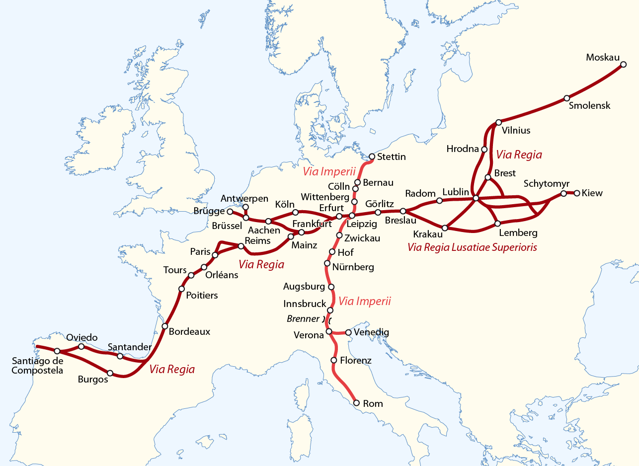
The Via Regia (Royal Highway) is a European Cultural Route following the route of the historic road of the Middle Ages. There were many such ''viae regiae'' associated with the king in the medieval Holy Roman Empire. History Origins The Via Regia ran west–east through the centre of the Holy Roman Empire, from the Rhine at Mainz-Kastel (''Elisabethenstraße'') to Frankfurt am Main, trade city and site of the election of the King of the Romans, continuing along Hanau, the '' Kaiserpfalz'' at Gelnhausen, the towns of Steinau an der Straße, Neuhof, Fulda and Eisenach to Erfurt, a centre of woad production. It ran further eastwards to Eckartsberga, crossing the Saale river between Bad Kösen and Naumburg and reached Leipzig, another trade city. The eastern part continued through Upper Lusatia ('' Via Regia Lusatiae Superioris'') along Großenhain, Königsbrück, Kamenz, Bautzen and Görlitz to Wrocław in Silesia with further connection to Kraków in Poland. M ... [...More Info...] [...Related Items...] OR: [Wikipedia] [Google] [Baidu] |

.jpg)


