|
Helena River
The Helena River is a tributary of the Swan River in Western Australia. The river rises in country east of Mount Dale and flows north-west to Mundaring Weir, where it is dammed. It then flows west until it reaches the Darling Scarp. It passes through the western edge of the Darling Scarp between Gooseberry Hill, and Greenmount Hill before joining the Swan River at the southern edge of the historic town, now suburb, of Guildford. Catchment area Many of the tributaries of the Helena River are unnamed due to their seasonality and size. However, Nyaania Creek on the northern side of the catchment and Piesse Brook on the southern side are significant through moving through built up areas, which also makes them susceptible to urban environment issues. Upper Helena catchment (i.e. above Mundaring Weir) has on the north side of Lake C.Y. O'Connor (formerly the Helena River Reservoir) a range of named creeks that occur in State Forest no 71 and 13: *Manns Gully *Chinaman Gully ... [...More Info...] [...Related Items...] OR: [Wikipedia] [Google] [Baidu] |
Lower Helena Pipehead Dam
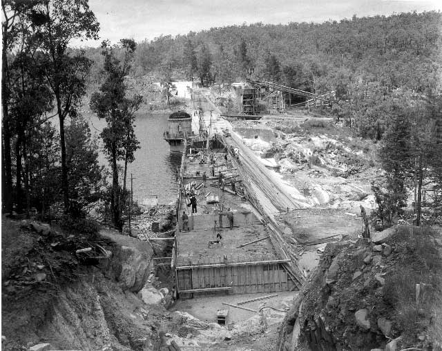
The Lower Helena Pipehead Dam, also known as the Lower Helena Pumpback Dam, catchment and pipeline are a part of the Goldfields Water Supply operations at Mundaring Weir, some distance east in the same valley, in the Darling Range in Western Australia. The suburb Helena Valley, Western Australia, Helena Valley is a few kilometres downstream of the dam. The dam was first constructed in the early 1970s, on the Helena River at a location on the southern boundary of the suburb of Darlington, Western Australia. By the 1980s and 1990s, the catchment and water quality saw a number of studies and reports. Into the 2000s, further research continued, and the upper parts of the catchment area were being considered as restricted activity zones. Notes {{coord, -31.942083, 116.076509, display=title Helena River Dams in Western Australia Goldfields Water Supply Scheme ... [...More Info...] [...Related Items...] OR: [Wikipedia] [Google] [Baidu] |
Swan Coastal Plain
The Swan Coastal Plain in Western Australia is the geographic feature which contains the Swan River as it travels west to the Indian Ocean. The coastal plain continues well beyond the boundaries of the Swan River and its tributaries, as a geological and biological zone, one of Western Australia's Interim Biogeographic Regionalisation for Australia (IBRA) regions.IBRA Version 6.1 data It is also one of the distinct physiographic provinces of the larger West Australian Shield division. Location and description The coastal plain is a strip on the Indian Ocean coast directly west of the |
Water Resource Management
Water resources are natural resources of water that are potentially useful for humans, for example as a source of drinking water supply or irrigation water. 97% of the water on the Earth is salt water and only three percent is fresh water; slightly over two thirds of this is frozen in glaciers and polar ice caps. The remaining unfrozen freshwater is found mainly as groundwater, with only a small fraction present above ground or in the air. Natural sources of fresh water include surface water, under river flow, groundwater and frozen water. Artificial sources of fresh water can include treated wastewater ( wastewater reuse) and desalinated seawater. Human uses of water resources include agricultural, industrial, household, recreational and environmental activities. Water resources are under threat from water scarcity, water pollution, water conflict and climate change. Fresh water is a renewable resource, yet the world's supply of groundwater is steadily decreasing, with depletio ... [...More Info...] [...Related Items...] OR: [Wikipedia] [Google] [Baidu] |
Mundaring Weir Road
Mundaring Weir Road (Kalamunda-Mundaring road) is a road in the outer eastern suburbs of Perth, Western Australia that links Mundaring and Kalamunda. Although an earlier rough track existed in a similar route, the Kalamunda-Mundaring road was developed in the late 1930s. It is the primary access route for Mundaring Weir, a dam and tourist attraction. It is a single carriageway for its entire length, with one lane in either direction. It crosses the alignment of the long since removed Mundaring Weir Railway a number of times, before crossing the Helena River just west of the first pumping station for the Goldfields Water Supply Scheme.Edmonds, Leigh (1998)''Large timber structures in Western Australia.'' Perth, W.A. Engineering Heritage Panel, Western Australia Division, Institution of Engineers (5 volumes) mention of the bridge downstream of Mundaring Weir It passes east of the Beelu National Park, and north of Mount Gunjin. It starts from Phillips Road in Mundaring ... [...More Info...] [...Related Items...] OR: [Wikipedia] [Google] [Baidu] |
Shire Of Mundaring
The Shire of Mundaring is a local government area in eastern metropolitan Perth, the capital of Western Australia. The Shire covers an area of and had a population of approximately 38,000 as at the 2016 Census. History The Greenmount Road District was created on 17 April 1903. On 29 March 1934, it was renamed the Mundaring Road District. On 1 July 1961, it became the Shire of Mundaring following the passage of the ''Local Government Act 1960'', which reformed all remaining road districts into shires. Statistics Mundaring Shire has published the following statistics for the period 1994-2006: * Population: 35,097 * Area: 643.32 km² * Rateable area: 205.91 km² * Rateable properties: 15,251 * Revenue: A$50.1M * Vested reserves: 104.60 km² * Forests and National Parks: 238.30 km² Wards The shire is divided into four wards. * West Ward - three councillors * South Ward - three councillors * Central Ward - three councillors * East Ward - three councillor ... [...More Info...] [...Related Items...] OR: [Wikipedia] [Google] [Baidu] |
Lower Helena Pipehead Dam From North West
Lower may refer to: *Lower (surname) *Lower Township, New Jersey *Lower Receiver (firearms) *Lower Wick Lower Wick is a small hamlet located in the county of Gloucestershire, England. It is situated about five miles south west of Dursley, eighteen miles southwest of Gloucester and fifteen miles northeast of Bristol. Lower Wick is within the civil ... Gloucestershire, England See also * Nizhny {{Disambiguation ... [...More Info...] [...Related Items...] OR: [Wikipedia] [Google] [Baidu] |
Goldfields Water Supply Scheme
The Goldfields Water Supply Scheme is a pipeline and dam project that delivers potable water from Mundaring Weir in Perth to communities in Western Australia's Eastern Goldfields, particularly Coolgardie and Kalgoorlie. The project was commissioned in 1896 and completed in 1903. The pipeline continues to operate today, supplying water to over 100,000 people in over 33,000 households as well as mines, farms and other enterprises. Water scarcity During the early 1890s, thousands of settlers had travelled into the barren and dry desert centre of Western Australia seeking gold, but the existing infrastructure for the supply of water was non-existent, and an urgent need arose. Prior to the scheme, water condensers, irregular rain, and water trains were part of the range of sources. Railway dams were essential for water to supply locomotives to travel to the goldfields. Origins of the scheme Throughout the 1890s, water availability issues in Coolgardie and in the Kalgoorlie ... [...More Info...] [...Related Items...] OR: [Wikipedia] [Google] [Baidu] |
Midland Railway Workshops
The Midland Railway Workshops in Midland, Western Australia, were the main workshops for the Western Australian Government Railways (WAGR) for over 80 years. History The first railway workshops in Western Australia were located at Fremantle and shifted to Midland in 1904. The Midland Railway Workshops were involved with all WAGR rolling stock and engine construction and maintenance. Steam engines continued to operate on mainline service until 1971, and all major maintenance occurred at the workshops. Workforce Generations of workers at the workshops had considerable numbers of European migrants who arrived in Australia with limited English language, and there were significant groups of Italian migrants in the workforce. The workforce of the workshops had a rich history and, since closing, there have been projects to record oral history and collect information about the place and people involved. Closure In April 1993, the Richard Court Liberal State Government announced th ... [...More Info...] [...Related Items...] OR: [Wikipedia] [Google] [Baidu] |
Midland, Western Australia
Midland is a suburb in the Perth metropolitan region, as well as the regional centre for the City of Swan local government area that covers the Swan Valley and parts of the Darling Scarp to the east. It is situated at the intersection of Great Eastern Highway and Great Northern Highway. Its eastern boundary is defined by the Roe Highway. Midland is almost always regarded as a suburb of Perth, being only away from the city centre. History Railway Midland was the site of the Midland Railway Workshops - the main workshops for the Western Australian Government Railways (WAGR) for over 80 years. It was also a terminus for the Midland Railway Company. At the end of the Second World War it was the junction of the Midland Railway, the Upper Darling Range Railway, and the main Eastern Railway. The Transperth suburban railway system currently has a terminus at Midland station. Until 1966 the earlier railway station at Midland was the connecting location for trains to Be ... [...More Info...] [...Related Items...] OR: [Wikipedia] [Google] [Baidu] |
Bellevue, Western Australia
Bellevue is an eastern suburb of Perth, Western Australia in the local government areas of the City of Swan and the Shire of Mundaring. It is at the foot of the slopes of Greenmount, a landmark on the Darling Scarp that is noted in the earliest of travel journals of the early Swan River Colony. Community Bellevue has been bisected by the Roe Highway, railway, and substantial changes in the eastern parts of Midland. The Bellevue Primary School was closed and amalgamated with the Koongamia Primary School to form the new Clayton View Primary School slightly up the hill towards Greenmount. It was the location of the original offices of what became the Mundaring Shire Council. It was also the location of the Catholic Church that preceded the St Anthony's church in Greenmount. A significant point of contact in the twentieth century for the local community was the Darling Range Hotel. Geography Bellevue is bounded by the Helena River to the south, Great Eastern Highway to the ... [...More Info...] [...Related Items...] OR: [Wikipedia] [Google] [Baidu] |
Helena Valley, Western Australia
Helena Valley is the name of a river valley and a locality in the foothills of the Darling Scarp in Perth, Western Australia. Geology The river valley is the centre of the catchment of the Helena River and extends from the edge of the Darling Scarp where Boya, Gooseberry Hill and Helena Valley define the "mouth" of the valley that opens to the Swan Coastal Plain, east and south east past Mundaring Weir and Lake C.Y. O'Connor to its origins in the region of Mount Dale. The soils of Helena Valley are characteristic of the eastern Swan Coastal Plain, ranging from sand to loam and clay, with a neutral pH tending towards moderately acid. Locality The locality is within the Shire of Mundaring, situated just south west of Boya and Greenmount Hill, 5 kilometres from Midland. It consists of many rural houses, but also contains six estates, and a shopping centre located in one of the estates. Helena Valley Primary School is located at the base of Greenmount Hill.http://www.helena ... [...More Info...] [...Related Items...] OR: [Wikipedia] [Google] [Baidu] |


