|
Hackney Wick
Hackney Wick is a neighbourhood in east London, England. The area forms the south-eastern part of the district of Hackney, and also of the wider London Borough of Hackney. Adjacent areas of the London Borough of Tower Hamlets are sometimes also described as being part of Hackney Wick. The area lies 4.2 miles (6.8 km) northeast of Charing Cross. Geography Hackney Wick is the south-eastern part of the historic district of Hackney, and also of the wider modern London Borough of Hackney. Adjacent parts of Old Ford (including Fish Island) in the London Borough of Tower Hamlets are also sometimes described as Hackney Wick, due to similar post-industrial land uses and their proximity to Hackney Wick railway station. The boundary runs along Wallis Road and the railway. The core area lies west of the Lee Navigation, here called Hackney Cut, however the parts of the Queen Elizabeth Olympic Park within Hackney have often also been described as Hackney Wick, and the ''East Wick' ... [...More Info...] [...Related Items...] OR: [Wikipedia] [Google] [Baidu] |
Fish Island, London
Fish Island is the name given to an area in east London, England in the London Borough of Tower Hamlets. It encompasses one of 58 designated Conservation area (United Kingdom), conservation areas in Tower Hamlets, with many of its buildings considered important to Britain's industrial heritage, though there are no listed buildings in the area. Regeneration and construction projects in Fish Island from 2016 onwards have caused the area to be referred to as "the new Shoreditch", in reference to the gentrification of that neighbourhood in the late 1990s. Nearby Hackney Wick has a similar character to Fish Island and this sometimes leads to Fish Island being described as part of Hackney Wick, though they are in different boroughs. Fish Island, despite its name, is not an actual island. Location The area of Fish Island runs along the river Lea and borders the Queen Elizabeth Olympic Park to the east. It is separated from Bow, London, Bow to the west by the A12 road (England), A12 ... [...More Info...] [...Related Items...] OR: [Wikipedia] [Google] [Baidu] |
Hackney South And Shoreditch (UK Parliament Constituency)
Hackney South and Shoreditch is a List of United Kingdom Parliament constituencies, constituency represented in the House of Commons of the United Kingdom, House of Commons of the Parliament of the United Kingdom, UK Parliament since 2005 by Meg Hillier of Labour Co-operative, Labour Co-op. History The seat was created in February 1974 from the former seat of Shoreditch and Finsbury (UK Parliament constituency), Shoreditch and Finsbury. Ronald Brown (English politician), Ronald Brown was elected in 1974 as a representative of the Labour Party (UK), Labour Party but defected from Her Majesty's Opposition, the Opposition to join the fledgling Social Democratic Party (UK), Social Democratic Party (SDP) in 1981, at a time when Labour wished for Common Market withdrawal and the removal of keeping a nuclear deterrent during the Cold War. Brown held the seat as an SDP member until 1983, when he was defeated by Labour Party candidate Brian Sedgemore. Sedgemore announced his retirement f ... [...More Info...] [...Related Items...] OR: [Wikipedia] [Google] [Baidu] |
Homerton
Homerton ( ) is an area in London, England, in the London Borough of Hackney. It is bordered to the west by Hackney Central, to the north by Lower Clapton, in the east by Hackney Wick, Leyton and by South Hackney to the south. In 2019, it had a population of 14,658 people. In terms of ethnicity it was 43.9% White, 33.0% Black, 10.9% Asian and 7.8% Mixed. It covered an area of 0.830 sq kilometres. Homerton ward on Hackney Borough Council is currently represented by three Labour councillors. There are fifty listed buildings located within the boundaries of the ward. History Origins Archaeological excavations at Link Street exposed a building dating to the 11th or 12th century suggesting that Homerton existed before it was first recorded in 1343. The hamlet of Homerton (Humberton or Hummerton, named for the farm of a woman named Hunburh) developed for about a half-mile along the road on the north side of the now buried and lost Hackney Brook, within the vale formed by the broo ... [...More Info...] [...Related Items...] OR: [Wikipedia] [Google] [Baidu] |
Hackney Brook
The Hackney Brook is one of the subterranean rivers of London. It crossed the northern parts of the current London boroughs of Hackney and Islington, emptying into the River Lea at Old Ford, with its source in Holloway. Course of the River In Hackney, the river ran through the northern part of Clissold Park, where its course is now marked by two lakes. It crossed the artificial New River, which flowed at right angles to the brook and left the park to the south (until the 1940s when the New River flow was terminated at the East Reservoir). The two Clissold park lakes are now fed from the main water supply, not the brook. It then wandered through Abney Park Cemetery to cross at the bottom of the road Stamford Hill to run along the north side of Stoke Newington Common. At this point, builders found, in the 1860s, very early evidence of human occupation in the form of 200,000-year-old palaeolithic flint axes, which were being made on the banks of the brook. These are among th ... [...More Info...] [...Related Items...] OR: [Wikipedia] [Google] [Baidu] |
Grazing
In agriculture, grazing is a method of animal husbandry whereby domestic livestock are allowed outdoors to roam around and consume wild vegetations in order to convert the otherwise indigestible (by human gut) cellulose within grass and other forages into meat, milk, wool and other animal products, often on land unsuitable for arable farming. Farmers may employ many different strategies of grazing for optimum production: grazing may be continuous, seasonal, or rotational within a grazing period. Longer rotations are found in ley farming, alternating arable and fodder crops; in rest rotation, deferred rotation, and mob grazing, giving grasses a longer time to recover or leaving land fallow. Patch-burn sets up a rotation of fresh grass after burning with two years of rest. Conservation grazing proposes to use grazing animals to improve the biodiversity of a site, but studies show that the greatest benefit to biodiversity comes from removing grazing animals from the landscape. ... [...More Info...] [...Related Items...] OR: [Wikipedia] [Google] [Baidu] |
Alfred The Great
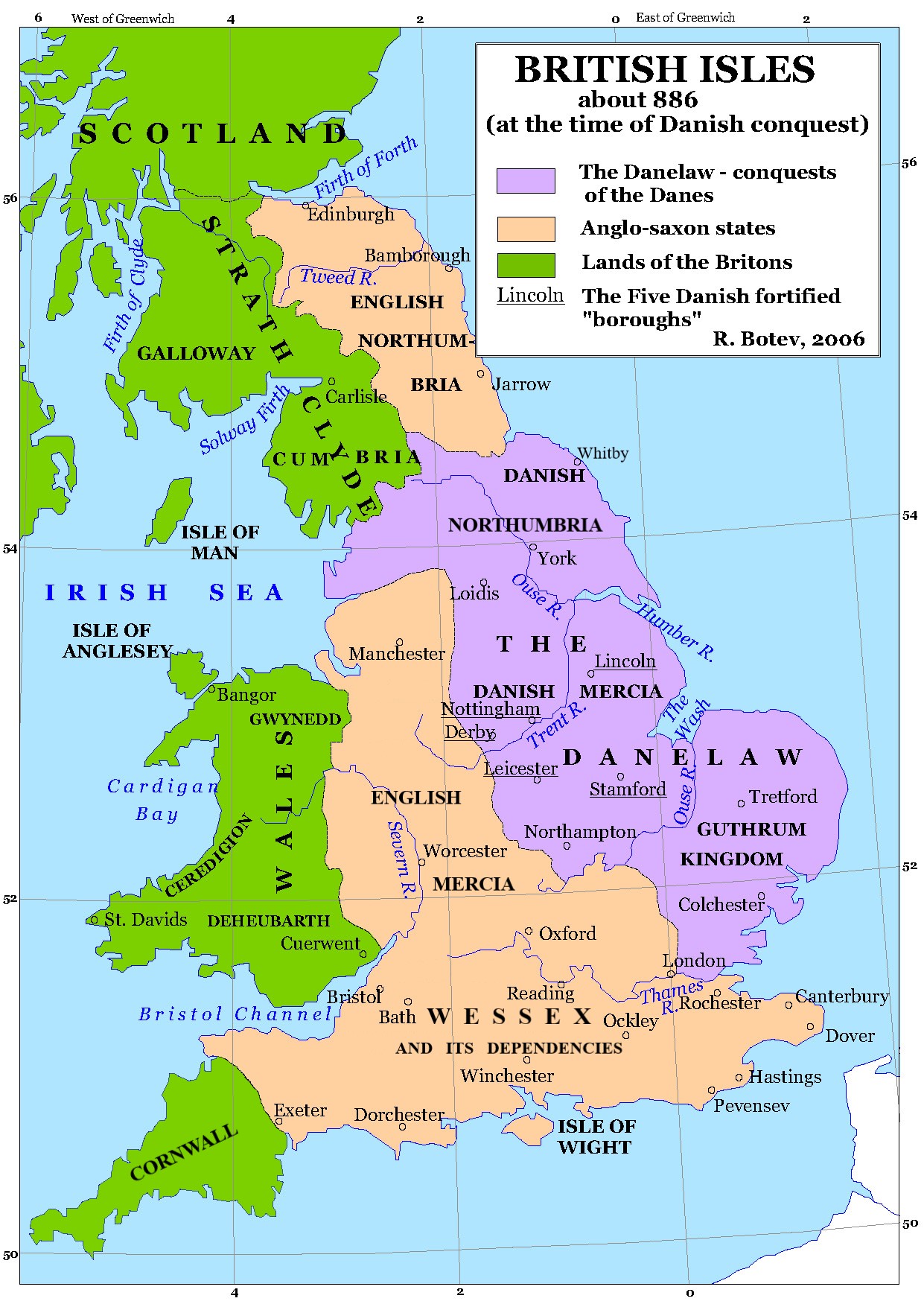
Alfred the Great (alt. Ælfred 848/849 – 26 October 899) was King of the West Saxons from 871 to 886, and King of the Anglo-Saxons from 886 until his death in 899. He was the youngest son of King Æthelwulf and his first wife Osburh, who both died when Alfred was young. Three of Alfred's brothers, Æthelbald, Æthelberht and Æthelred, reigned in turn before him. Under Alfred's rule, considerable administrative and military reforms were introduced, prompting lasting change in England. After ascending the throne, Alfred spent several years fighting Viking invasions. He won a decisive victory in the Battle of Edington in 878 and made an agreement with the Vikings, dividing England between Anglo-Saxon territory and the Viking-ruled Danelaw, composed of northern England, the north-east Midlands and East Anglia. Alfred also oversaw the conversion of Viking leader Guthrum to Christianity. He defended his kingdom against the Viking attempt at conquest, becoming the dominant ruler ... [...More Info...] [...Related Items...] OR: [Wikipedia] [Google] [Baidu] |
Danes
Danes ( da, danskere, ) are a North Germanic ethnic group and nationality native to Denmark and a modern nation identified with the country of Denmark. This connection may be ancestral, legal, historical, or cultural. Danes generally regard themselves as a nationality and reserve the word "ethnic" for the description of recent immigrants, sometimes referred to as "new Danes". The contemporary Danish national identity is based on the idea of "Danishness", which is founded on principles formed through historical cultural connections and is typically not based on racial heritage. History Early history Denmark has been inhabited by various Germanic peoples since ancient times, including the Angles, Cimbri, Jutes, Herules, Teutones and others. The first mentions of " Danes" are recorded in the mid-6th century by historians Procopius ( el, δάνοι) and Jordanes (''danī''), who both refer to a tribe related to the Suetidi inhabiting the peninsula of Jutland, the province of Sc ... [...More Info...] [...Related Items...] OR: [Wikipedia] [Google] [Baidu] |
Tidal Estuary
An estuary is a partially enclosed coastal body of brackish water with one or more rivers or streams flowing into it, and with a free connection to the open sea. Estuaries form a transition zone between river environments and maritime environments and are an example of an ecotone. Estuaries are subject both to marine influences such as tides, waves, and the influx of saline water, and to fluvial influences such as flows of freshwater and sediment. The mixing of seawater and freshwater provides high levels of nutrients both in the water column and in sediment, making estuaries among the most productive natural habitats in the world. Most existing estuaries formed during the Holocene epoch with the flooding of river-eroded or glacially scoured valleys when the sea level began to rise about 10,000–12,000 years ago. Estuaries are typically classified according to their geomorphological features or to water-circulation patterns. They can have many different names, such as bays, harb ... [...More Info...] [...Related Items...] OR: [Wikipedia] [Google] [Baidu] |
River Lea
The River Lea ( ) is in South East England. It originates in Bedfordshire, in the Chiltern Hills, and flows southeast through Hertfordshire, along the Essex border and into Greater London, to meet the River Thames at Bow Creek. It is one of the largest rivers in London and the easternmost major tributary of the Thames. The river's significance as a major east–west barrier and boundary has tended to obscure its importance as north–south trade route. Below Hertford the river has since medieval times had alterations made to make it more navigable for boats between the Thames and eastern Hertfordshire and Essex, known as the Lee Navigation. This stimulated much industry along its banks. The navigable River Stort, the main tributary, joins it at Hoddesdon. While the lower Lea remains somewhat polluted, its upper stretch and tributaries, classified as chalk streams, are a major source of drinking water for London. An artificial waterway known as the New River, opened in 1613, ... [...More Info...] [...Related Items...] OR: [Wikipedia] [Google] [Baidu] |
Ancient Rome
In modern historiography, ancient Rome refers to Roman civilisation from the founding of the city of Rome in the 8th century BC to the collapse of the Western Roman Empire in the 5th century AD. It encompasses the Roman Kingdom (753–509 BC), Roman Republic (509–27 BC) and Roman Empire (27 BC–476 AD) until the fall of the western empire. Ancient Rome began as an Italic settlement, traditionally dated to 753 BC, beside the River Tiber in the Italian Peninsula. The settlement grew into the city and polity of Rome, and came to control its neighbours through a combination of treaties and military strength. It eventually dominated the Italian Peninsula, assimilated the Greek culture of southern Italy ( Magna Grecia) and the Etruscan culture and acquired an Empire that took in much of Europe and the lands and peoples surrounding the Mediterranean Sea. It was among the largest empires in the ancient world, with an estimated 50 to 90 million inhabitants, roughly 20% of t ... [...More Info...] [...Related Items...] OR: [Wikipedia] [Google] [Baidu] |
Metropolitan Borough Of Hackney
The Metropolitan Borough of Hackney was a Metropolitan boroughs of the County of London, Metropolitan borough of the County of London from 1900 to 1965. Its area became part of the London Borough of Hackney. Formation and boundaries The borough was one of twenty-eight metropolitan boroughs created by the London Government Act 1899. It was the successor to the vestry of the Hackney (parish), parish of Hackney, which had been the local authority since 1894. Between 1855 and 1894 the parish had been administered with Stoke Newington as the Hackney District (Metropolis), Hackney District. The boundaries of Hackney with the neighbouring boroughs were adjusted slightly in 1900: Hackney gained the east side of Bethune Road from Metropolitan Borough of Stoke Newington, Stoke Newington and the south side of Balls Pond Road from Islington; it lost the west side of Southgate Road to Islington. The boundary with Metropolitan Borough of Shoreditch, Shoreditch was altered to run along the Rege ... [...More Info...] [...Related Items...] OR: [Wikipedia] [Google] [Baidu] |
Hackney (parish)
Hackney was a parish in the historic county of Middlesex. The parish church of St John-at-Hackney was built in 1789, replacing the nearby former 16th-century parish church dedicated to St Augustine (pulled down in 1798). The original tower of that church was retained to hold the bells until the new church could be strengthened; the bells were finally removed to the new St John's in 1854. See details of other, more modern, churches within the original parish boundaries below. Ancient parish The vestry of the parish, in common with all parishes in England, was entrusted with various administrative functions from the 17th century. The parish vestry administered the Poor Law until 1837, until it became part of the Poor Law Union of Hackney. The ecclesiastical and civil roles of the parish increasingly diverged, and by the early nineteenth century they covered different areas. Civil parish A distinct civil parish dates from 1855, with the incorporation of ''The Vestry of the Parish ... [...More Info...] [...Related Items...] OR: [Wikipedia] [Google] [Baidu] |


