|
Höllbachgspreng
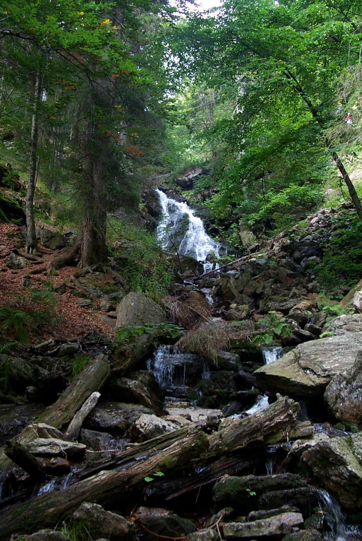
The Höllbachgspreng is a wooded rock massif below the Großer Falkenstein mountain in the vicinity of Lindberg in the Bavarian Forest, Germany. Description This terrain hollow with extremely steep sides owes its formation to the last ice age. A mountain trail runs through the ancient forest here. Through a narrow, ravine the Höllbach rushes between, gneiss rocks as high as a house in places. On the northern boundary of the region it drops as a waterfall into the depths. The western part of the area is dominated by the Großer Falkenstein. The slopes are covered with trees such as Acer pseudoplatanus, sycamore, Norway spruce, Fagus sylvatica, beech, Abies alba, silver fir and Ulmus glabra, wych elm. The undergrowth includes rare plants like alpine lady-fern, chickweed-wintergreen, sundews, martagon lily and Hungarian gentian. On the rocks grows the very rare Chrysothrix, sulphur dust lichen (''Schwefelflechte''). As far as birds are concerned the region is relatively species-p ... [...More Info...] [...Related Items...] OR: [Wikipedia] [Google] [Baidu] |
Großer Falkenstein
The Großer Falkenstein or Great Falkenstein, is a mountain, high, in the Bavarian Forest about five kilometres southeast of Bayerisch Eisenstein in the Falkenstein-Rachel region of the Bavarian Forest National Park. Views From the summit cross there are extensive views to the west and south of the Großer Arber, the Großer Osser, the town of Zwiesel and the Großer Rachel. To the west and lower is the Kleiner Falkenstein, also a worthwhile viewing point. Ascent An ascent to the summit is possible in around 2 hours following the trails marked Heidelbeere, Eibe, Silberblatt and Esche from the start points of Zwieslerwaldhaus, Kreuzstraßl and Scheuereck. Worth seeing is the so-called Höllbachgspreng, an area of rocky terrain with a gorge and stream that has several waterfalls and numerous runnels descending to the Höllbachschwelle, a small lake. The path through this area is very challenging and should only be attempted by experienced hikers. Mountain hut At the s ... [...More Info...] [...Related Items...] OR: [Wikipedia] [Google] [Baidu] |
Lindberg
Lindberg is a municipality in the district of Regen in Bavaria in Germany in the immediate neighbourhood of the larger town Zwiesel. Location Lindberg lies in the Danube Forest (''Donau-Wald'') region in the middle of the Bavarian Forest on the Glasstraße at the foot of the 1,315-metre-high Falkenstein only four kilometres from Zwiesel and 14 km northeast of the county town of Regen Regen (; Northern Bavarian: ''Reng'') is a town in Bavaria, Germany, and the district town of the district of Regen. Geography Regen is situated on the great Regen River, located in the Bavarian Forest. Divisions Originally the town consiste ..., 30 km northwest of Grafenau and 14 km from the border at Bayerisch Eisenstein. Sights * Höllbachgspreng References Regen (district) {{Regendistrict-geo-stub ... [...More Info...] [...Related Items...] OR: [Wikipedia] [Google] [Baidu] |
Bavarian Forest
image:Zell-bayerischer-wald.jpg, The village of Zell in the Bavarian Forest The Bavarian Forest ( or ''Bayerwald'' ; ) is a wooded, low-mountain region in Bavaria, Germany, that is about 100 kilometres long. It runs along the Czech Republic, Czech border and is continued on the Czech side by the Bohemian Forest (Czech: ''Šumava''). Most of the Bavarian Forest lies within the province of Lower Bavaria, but the northern part lies within the Upper Palatinate. In the south it reaches the border with Upper Austria. Geologically and geomorphologically, the Bavarian Forest is part of the Bohemian Forest - the highest of the truncated highlands of the Bohemian Massif. The area along the Czech border has been designated as the Bavarian Forest National Park (240 km2), established in 1970 as the first national park in Germany. Another 3,008 km2 has been designated as the Bavarian Forest Nature Park, established 1967, and another 1,738 km2 as the Upper Bavarian Forest Natur ... [...More Info...] [...Related Items...] OR: [Wikipedia] [Google] [Baidu] |
Sundew
''Drosera'', which is commonly known as the sundews, is one of the largest genera of carnivorous plants, with at least 194 species. 2 volumes. These members of the family Droseraceae lure, capture, and digest insects using stalked mucilaginous glands covering their leaf surfaces. The insects are used to supplement the poor mineral nutrition of the soil in which the plants grow. Various species, which vary greatly in size and form, are native to every continent except Antarctica. Charles Darwin performed much of the early research into ''Drosera'', engaging in a long series of experiments with ''Drosera rotundifolia'' which were the first to confirm carnivory in plants. In an 1860 letter, Darwin wrote, “…at the present moment, I care more about ''Drosera'' than the origin of all the species in the world.” Taxonomy The botanical name from the Greek ''drosos'' "dew, dewdrops" refer to the glistening drops of mucilage at the tip of the glandular trichomes that resemble d ... [...More Info...] [...Related Items...] OR: [Wikipedia] [Google] [Baidu] |
Waterfalls Of Germany
This list of notable waterfalls of the world is sorted by continent, then country, then province, state or territory. A waterfall is included if it is at least tall and has an existing Wikipedia article, or it is considered historically significant based on multiple reliable references. There is no standard way to measure the height or width of a waterfall. No ranking of waterfalls should be assumed because of the heights or widths provided in the list. Many numbers are estimated and measurements may be imprecise. See additional lists of waterfalls by List of waterfalls by height, height, List of waterfalls by flow rate, flow rate and List of waterfalls by type, type. Africa Angola * Kalandula Falls – high Burundi * Kagera waterfalls, Kagera Falls * Rusumo Falls Central African Republic * Boali, Boali Falls Chad * Gauthiot Falls Democratic Republic of the Congo * Boyoma Falls – formerly known as Stanley Falls; highest flow rate in the world * Inga ... [...More Info...] [...Related Items...] OR: [Wikipedia] [Google] [Baidu] |
Bavarian Forest National Park
The Bavarian Forest National Park () is a national park in the Eastern Bavarian Forest immediately on Germany's border with the Czech Republic. It was founded on 7 October 1970 as the first national park in Germany. Since its expansion on 1 August 1997 it has covered an area of 24,250 hectares. Together with the neighbouring Czech Bohemian Forest the Bavarian Forest forms the largest contiguous area of forest in Central Europe. Description Especially protected are the Norway spruce–dominated highland forests, mixed mountain forests of European silver fir, European beech and spruce trees and water meadow spruce woods in the valleys. Although a few remnants of ancient forest remain, the National Park area is still heavily influenced by the former forestry industry. Since nature is now left to take its course again, there is no human intervention when there are catastrophic events such as large scale bark beetle infestation. This resulted in the death of a portion of the hig ... [...More Info...] [...Related Items...] OR: [Wikipedia] [Google] [Baidu] |
Upper Palatinate
The Upper Palatinate (; , , ) is an administrative district in the east of Bavaria, Germany. It consists of seven districts and 226 municipalities, including three cities. Geography The Upper Palatinate is a landscape with low mountains and numerous ponds and lakes in its lowland regions. By contrast with other regions of Germany it is more rural in character and more sparsely settled. It borders (clockwise from the north) on Upper Franconia, the Czech Republic, Lower Bavaria, Upper Bavaria and Middle Franconia. Notable regions are: * Stiftland, former estate and territorial lordship of Waldsassen Abbey with the market town of Konnersreuth, Fockenfeld Abbey, the town of Waldsassen and about 150 other villages. * Upper Palatine Forest with deep valleys and many castles * Upper Palatine Lake District with the Steinberger See * Upper Palatine Jura, part of the Franconian Jura * Steinwald including the Teichelberg and Pechbrunn * Waldnaab/ Wondreb Depression * Bavarian ... [...More Info...] [...Related Items...] OR: [Wikipedia] [Google] [Baidu] |
Lower Bavaria
Lower Bavaria (, ; ) is one of the seven administrative regions of Bavaria, Germany, located in the east of the state. It consists of nine districts and 258 municipalities (including three cities). Geography Lower Bavaria is subdivided into two regions () – Landshut and Donau-Wald. Recent election results mark it as the most conservative part of Germany, generally giving huge margins to the CSU. This part of Bavaria includes the Bavarian Forest, a well-known tourist destination in Germany, and the Lower Bavarian Upland. ''Landkreise''(districts) # Deggendorf # Dingolfing-Landau # Freyung-Grafenau # Kelheim # Landshut # Passau # Regen # Rottal-Inn # Straubing-Bogen ''Kreisfreie Städte''(district-free towns) # Landshut # Passau # Straubing Population Economy The gross domestic product (GDP) of the region was €48.5 billion in 2018, accounting for 1.4% of German economic output. GDP per capita adjusted for purchasing power was €36,100 or 120% of the EU27 avera ... [...More Info...] [...Related Items...] OR: [Wikipedia] [Google] [Baidu] |
Sure-footedness
Sure-footedness is the ability, especially when hiking or mountain climbing, to navigate difficult or rough terrain safely. Such situations place demands on a person's coordination and reserves of strength as well as requiring sufficient appreciation of the terrain. A person who is sure-footed is thus unlikely to slip or stumble, and will have a good head for heights when required. On many hiking trails and mountain tours, sure-footedness is assumed to be a prerequisite without ever being defined. The term is frequently used in the literature presumably to ensure that the reader is made sufficiently aware that, under certain circumstances, one false step may lead to serious consequences. Required attributes Although there is no standard definition of sure-footedness, [...More Info...] [...Related Items...] OR: [Wikipedia] [Google] [Baidu] |
Chrysothrix
''Chrysothrix'' is a genus of lichen-forming fungi in the family Chrysotrichaceae. They are commonly called gold dust lichens or sulfur dust lichens,Field Guide to California Lichens, Stephen Sharnoff, Yale University Press, 2014, because they are bright yellow to greenish-yellow, sometimes flecked with orange, and composed entirely of powdery soredia.Brodo, I. M., S. D. Sharnoff, and S. Sharnoff. 2001. Lichens of North America. Yale University Press: New Haven. Apothecia An ascocarp, or ascoma (: ascomata), is the fruiting body ( sporocarp) of an ascomycete phylum fungus. It consists of very tightly interwoven hyphae and millions of embedded asci, each of which typically contains four to eight ascospores. As ... are never present in North American specimens. They grow on bark or rocks, generally in shaded habitats. They can sometimes be mistaken for sterile specimens of ''Chaenotheca'', which usually has pinhead apothecia on tiny stalks, or ''Psilolechia'', which us ... [...More Info...] [...Related Items...] OR: [Wikipedia] [Google] [Baidu] |


