|
Hood River Bridge
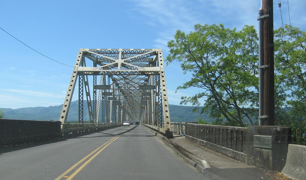
The Hood River-White Salmon Interstate Bridge, or just the Hood River Bridge is a truss bridge with a vertical lift that spans the Columbia River between Hood River, Oregon and White Salmon, Washington. It connects Interstate 84/ U.S. Route 30 on the Oregon side with Washington State Route 14. The bridge is currently the second oldest road bridge across the Columbia between Washington and Oregon. It was built by the Oregon-Washington Bridge Company and opened on December 9, 1924. The original name was the Waucoma Interstate Bridge. Construction of the Bonneville Dam downstream forced the bridge to be altered in 1938 to accommodate the resulting elevated river levels. On December 12, 1950, the Port of Hood River purchased the bridge from the Oregon-Washington Bridge Co. for $800,000. The bridge is operated as a toll bridge by the Port of Hood River. Currently the tolls are set to $2.00 for a passenger car, with $3.00 for each axle for a truck, and either 75¢ or $1.00 ... [...More Info...] [...Related Items...] OR: [Wikipedia] [Google] [Baidu] |
Columbia River
The Columbia River ( Upper Chinook: ' or '; Sahaptin: ''Nch’i-Wàna'' or ''Nchi wana''; Sinixt dialect'' '') is the largest river in the Pacific Northwest region of North America. The river rises in the Rocky Mountains of British Columbia, Canada. It flows northwest and then south into the U.S. state of Washington, then turns west to form most of the border between Washington and the state of Oregon before emptying into the Pacific Ocean. The river is long, and its largest tributary is the Snake River. Its drainage basin is roughly the size of France and extends into seven US states and a Canadian province. The fourth-largest river in the United States by volume, the Columbia has the greatest flow of any North American river entering the Pacific. The Columbia has the 36th greatest discharge of any river in the world. The Columbia and its tributaries have been central to the region's culture and economy for thousands of years. They have been used for transportat ... [...More Info...] [...Related Items...] OR: [Wikipedia] [Google] [Baidu] |
River Mile
A river mile is a measure of distance in miles along a river from its mouth. River mile numbers begin at zero and increase further upstream. The corresponding metric unit using kilometers is the river kilometer. They are analogous to vehicle roadway mile markers, except that river miles are rarely marked on the physical river; instead they are marked on navigation charts, and topographic maps. Riverfront properties are sometimes partially legally described by their river mile. The river mile is not the same as the length of the river, rather it is a means of locating any feature along the river relative to its distance from the mouth, when measured along the course (or navigable channel) of the river. River mile zero may not be exactly at the mouth. For example, the Willamette River (which discharges into the Columbia River) has its river mile zero at the edge of the navigable channel in the Columbia, some beyond the mouth. Also, the river mile zero for the Lower Mississippi ... [...More Info...] [...Related Items...] OR: [Wikipedia] [Google] [Baidu] |
Road Bridges In Oregon
A road is a linear way for the conveyance of traffic that mostly has an improved surface for use by vehicles (motorized and non-motorized) and pedestrians. Unlike streets, the main function of roads is transportation. There are many types of roads, including parkways, avenues, controlled-access highways (freeways, motorways, and expressways), tollways, interstates, highways, thoroughfares, and local roads. The primary features of roads include lanes, sidewalks (pavement), roadways (carriageways), medians, shoulders, verges, bike paths (cycle paths), and shared-use paths. Definitions Historically many roads were simply recognizable routes without any formal construction or some maintenance. The Organization for Economic Co-operation and Development (OECD) defines a road as "a line of communication (travelled way) using a stabilized base other than rails or air strips open to public traffic, primarily for the use of road motor vehicles running on their own wheels", whic ... [...More Info...] [...Related Items...] OR: [Wikipedia] [Google] [Baidu] |
Columbia River Gorge
The Columbia River Gorge is a canyon of the Columbia River in the Pacific Northwest of the United States. Up to deep, the canyon stretches for over as the river winds westward through the Cascade Range, forming the boundary between the state of Washington to the north and Oregon to the south. Extending roughly from the confluence of the Columbia with the Deschutes River (and the towns of Roosevelt, Washington, and Arlington, Oregon) in the east down to the eastern reaches of the Portland metropolitan area, the water gap furnishes the only navigable route through the Cascades and the only water connection between the Columbia Plateau and the Pacific Ocean. It is thus that the routes of Interstate 84, U.S. Route 30, Washington State Route 14, and railroad tracks on both sides run through the gorge. A popular recreational destination, the gorge holds federally protected status as the Columbia River Gorge National Scenic Area and is managed by the Columbia River Gorge C ... [...More Info...] [...Related Items...] OR: [Wikipedia] [Google] [Baidu] |
Transportation Buildings And Structures In Klickitat County, Washington
Transport (in British English), or transportation (in American English), is the intentional movement of humans, animals, and goods from one location to another. Modes of transport include air, land (rail and road), water, cable, pipeline, and space. The field can be divided into infrastructure, vehicles, and operations. Transport enables human trade, which is essential for the development of civilizations. Transport infrastructure consists of both fixed installations, including roads, railways, airways, waterways, canals, and pipelines, and terminals such as airports, railway stations, bus stations, warehouses, trucking terminals, refueling depots (including fueling docks and fuel stations), and seaports. Terminals may be used both for interchange of passengers and cargo and for maintenance. Means of transport are any of the different kinds of transport facilities used to carry people or cargo. They may include vehicles, riding animals, and pack animals. Vehicles may in ... [...More Info...] [...Related Items...] OR: [Wikipedia] [Google] [Baidu] |
Buildings And Structures In Hood River, Oregon
A building, or edifice, is an enclosed structure with a roof and walls standing more or less permanently in one place, such as a house or factory (although there's also portable buildings). Buildings come in a variety of sizes, shapes, and functions, and have been adapted throughout history for a wide number of factors, from building materials available, to weather conditions, land prices, ground conditions, specific uses, prestige, and aesthetic reasons. To better understand the term ''building'' compare the list of nonbuilding structures. Buildings serve several societal needs – primarily as shelter from weather, security, living space, privacy, to store belongings, and to comfortably live and work. A building as a shelter represents a physical division of the human habitat (a place of comfort and safety) and the ''outside'' (a place that at times may be harsh and harmful). Ever since the first cave paintings, buildings have also become objects or canvasses of much artist ... [...More Info...] [...Related Items...] OR: [Wikipedia] [Google] [Baidu] |
Bridges Over The Columbia River
A bridge is a structure built to span a physical obstacle (such as a body of water, valley, road, or rail) without blocking the way underneath. It is constructed for the purpose of providing passage over the obstacle, which is usually something that is otherwise difficult or impossible to cross. There are many different designs of bridges, each serving a particular purpose and applicable to different situations. Designs of bridges vary depending on factors such as the function of the bridge, the nature of the terrain where the bridge is constructed and anchored, and the material used to make it, and the funds available to build it. The earliest bridges were likely made with fallen trees and stepping stones. The Neolithic people built boardwalk bridges across marshland. The Arkadiko Bridge (dating from the 13th century BC, in the Peloponnese) is one of the oldest arch bridges still in existence and use. Etymology The ''Oxford English Dictionary'' traces the origin of the wo ... [...More Info...] [...Related Items...] OR: [Wikipedia] [Google] [Baidu] |
1924 Establishments In Washington (state)
Nineteen or 19 may refer to: * 19 (number), the natural number following 18 and preceding 20 * one of the years 19 BC, AD 19, 1919, 2019 Films * ''19'' (film), a 2001 Japanese film * ''Nineteen'' (film), a 1987 science fiction film Music * 19 (band), a Japanese pop music duo Albums * ''19'' (Adele album), 2008 * ''19'', a 2003 album by Alsou * ''19'', a 2006 album by Evan Yo * ''19'', a 2018 album by MHD * ''19'', one half of the double album '' 63/19'' by Kool A.D. * ''Number Nineteen'', a 1971 album by American jazz pianist Mal Waldron * ''XIX'' (EP), a 2019 EP by 1the9 Songs * "19" (song), a 1985 song by British musician Paul Hardcastle. * "Nineteen", a song by Bad4Good from the 1992 album ''Refugee'' * "Nineteen", a song by Karma to Burn from the 2001 album ''Almost Heathen''. * "Nineteen" (song), a 2007 song by American singer Billy Ray Cyrus. * "Nineteen", a song by Tegan and Sara from the 2007 album '' The Con''. * "XIX" (song), a 2014 song by Slipknot ... [...More Info...] [...Related Items...] OR: [Wikipedia] [Google] [Baidu] |
US 197
U.S. Route 197 (US 197) is a north–south United States Highway, of which all but 2.76 miles of its 69.93 miles (4.44 of 112.54 km) are within the state of Oregon. The highway starts in rural Wasco County in Central Oregon at an intersection with US 97. US 197 travels north as a continuation of The Dalles-California Highway No. 4 through the cities of Maupin, Tygh Valley, and Dufur to The Dalles. Within The Dalles, the highway becomes concurrent with US 30 and intersects Interstate 84 (I-84) before it crosses over the Columbia River on The Dalles Bridge into Washington. The highway continues through the neighboring city of Dallesport in Klickitat County and terminates at a junction with State Route 14 (SR 14). US 197 was established in 1952 using the existing The Dalles-California Highway, itself created as a part of the initial named Oregon highways in 1917. US 197 traveled from its current northern te ... [...More Info...] [...Related Items...] OR: [Wikipedia] [Google] [Baidu] |
List Of Crossings Of The Columbia River ...
This is a list of bridges and other crossings of the Columbia River from the Pacific Ocean upstream to its source. Crossings See also * List of crossings of the Willamette River * Lists of Oregon-related topics * List of Washington-related topics * List of British Columbia-related topics References * * External links * {{Columbia River * Columbia River crossings Crossings Columbia River Columbia Columbia may refer to: * Columbia (personification), the historical female national personification of the United States, and a poetic name for America Places North America Natural features * Columbia Plateau, a geologic and geographic region in ... [...More Info...] [...Related Items...] OR: [Wikipedia] [Google] [Baidu] |
.jpg)


