|
History Of Curaçao
The history of Curaçao starts with settlement by the Arawaks, an Indigenous peoples of the Americas, Amerindian people coming from the South American mainland. They are believed to have inhabited the island for many hundreds of years before the arrival of Europeans. Pre-colonial history The earliest trace of human habitation on Curaçao can be found in Rooi Rincon. It consists in a natural overhang in the rocks used by aceramic, preceramic residents. The remains that have been found consist of waste heaps of shell, animal bone material and stone. The objects are made of stone and shell, which can be used for different purposes. There are also rock paintings here. The dating of these oldest remains of Curaçao is between about 2900 and 2300 BCE. Similar remains and human graves are known from Sint Michielsberg, c. 2000 to 1600 BCE. However, a recent study on charcoal material at the site of Saliña Sint Marie points towards human activity taking place as early as c. 3700 BCE. R ... [...More Info...] [...Related Items...] OR: [Wikipedia] [Google] [Baidu] |
Arawaks
The Arawak are a group of Indigenous peoples of northern South America and of the Caribbean. The term "Arawak" has been applied at various times to different Indigenous groups, from the Lokono of South America to the Taíno (Island Arawaks), who lived in the Greater Antilles and northern Lesser Antilles in the Caribbean. All these groups spoke related Arawakan languages. Name Early Spanish explorers and administrators used the terms ''Arawak'' and '' Caribs'' to distinguish the peoples of the Caribbean, with ''Carib'' reserved for Indigenous groups that they considered hostile and ''Arawak'' for groups that they considered friendly. In 1871, ethnologist Daniel Garrison Brinton proposed calling the Caribbean populace "Island Arawak" because of their cultural and linguistic similarities with the mainland Arawak. Subsequent scholars shortened this convention to "Arawak", creating confusion between the island and mainland groups. In the 20th century, scholars such as Irving Ro ... [...More Info...] [...Related Items...] OR: [Wikipedia] [Google] [Baidu] |
Dutch West India Company
The Dutch West India Company () was a Dutch chartered company that was founded in 1621 and went defunct in 1792. Among its founders were Reynier Pauw, Willem Usselincx (1567–1647), and Jessé de Forest (1576–1624). On 3 June 1621, it was granted a :wikisource:Charter of the Dutch West India Company, charter for a trade monopoly in the Dutch West Indies by the Republic of the Seven United Netherlands and given jurisdiction over Dutch participation in the Atlantic slave trade, Brazil, the Caribbean, and North America. The area where the company could operate consisted of West Africa (between the Tropic of Cancer and the Cape of Good Hope) and the Americas, which included the Pacific Ocean and ended east of the Maluku Islands, according to the Treaty of Tordesillas. The intended purpose of the charter was to eliminate competition, particularly Spanish or Portuguese, between the various trading posts established by the merchants. The company became instrumental in the largely eph ... [...More Info...] [...Related Items...] OR: [Wikipedia] [Google] [Baidu] |
Willemstad
Willemstad ( ; ; ; ) is the capital city, capital and largest city of Curaçao, an island in the southern Caribbean Sea that is a Countries of the Kingdom of the Netherlands, constituent country of the Kingdom of the Netherlands. It was the capital of the Netherlands Antilles prior to that entity's Dissolution of the Netherlands Antilles, dissolution in 2010. The city counts to have around 90% of Curaçao’s population, with 136,660 inhabitants as of 2011. The historic centre of the city consists of four quarters: the Punda and Otrobanda, which are separated by the Sint Anna Bay, an inlet that leads into the large natural harbour called the Schottegat, as well as the Scharloo and Pietermaai Smal quarters, which are across from each other on the smaller Waaigat harbour. Willemstad is home to the Curaçao synagogue, the oldest surviving synagogue in the Americas. The city centre, with its unique architecture and harbour entry, has been designated a UNESCO World Heritage Site. His ... [...More Info...] [...Related Items...] OR: [Wikipedia] [Google] [Baidu] |
Fort Amsterdam (Curaçao)
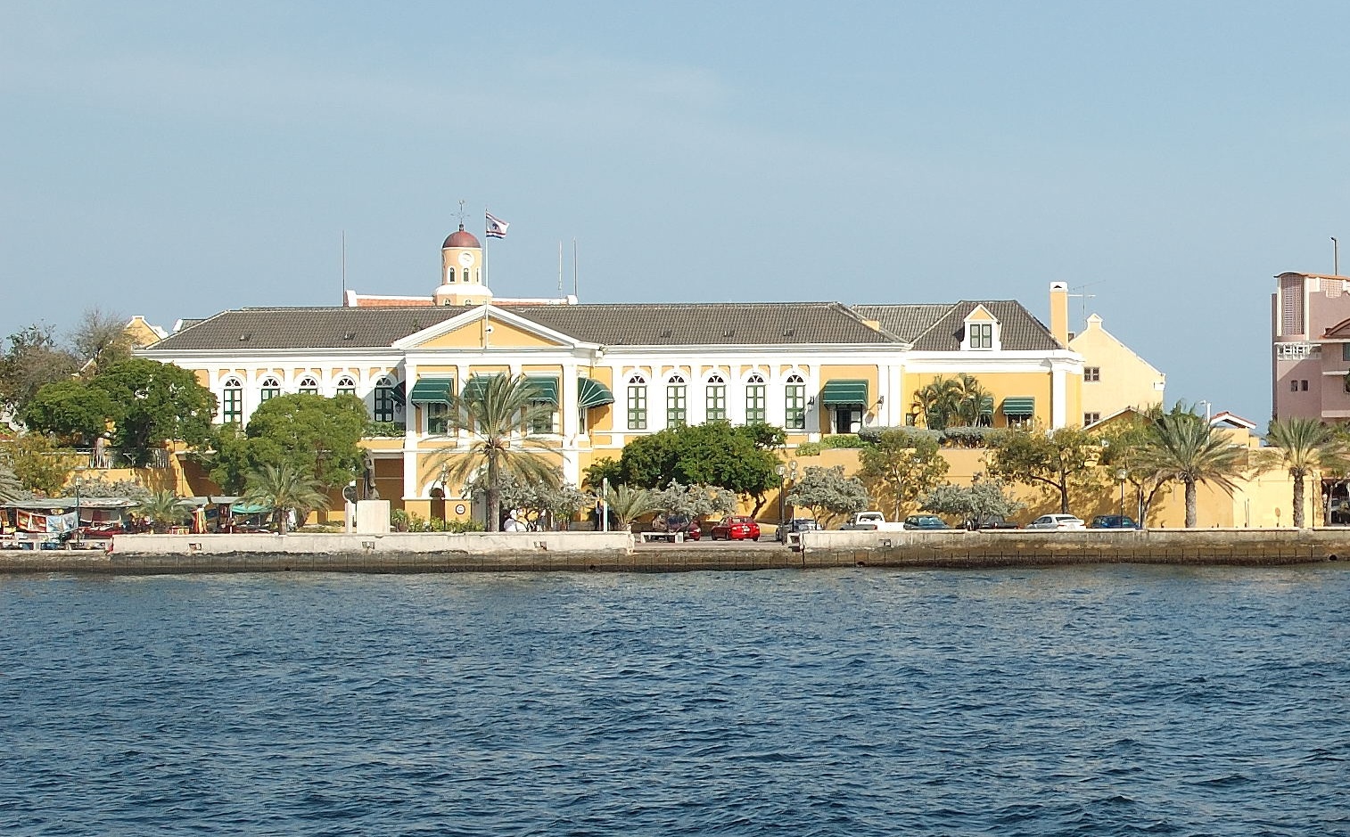
Fort Amsterdam is a fort located in Willemstad, Curaçao. It was constructed in 1634 by the Dutch West India Company (WIC) and served not only as a military fort but also as the headquarters of the WIC. Currently it serves as the seat of the government and governor of Curaçao. The fort is named after the Amsterdam chamber of the WIC and was considered the main of eight forts on the island. History Construction, design and use In the 1630s, the Dutch West India Company was searching for a new outpost in the Caribbean. The company set its sight on Curaçao, which was then a Spanish possession. In 1634, the Dutch admiral Johannes van Walbeeck, together with 200 soldiers, landed on the island and fought the 32 Spanish troops, who surrendered on 21 August 1634, after resisting for three weeks. Van Walbeeck ordered the construction of a fort at the mouth of the Sint Anna Bay. Dutch soldiers and slaves from Angola built the fort, which became the headquarters of the WIC from the outse ... [...More Info...] [...Related Items...] OR: [Wikipedia] [Google] [Baidu] |
Sint Anna Bay
Sint Anna Bay (Dutch: ''Sint Annabaai'') is a deep channel approximately one mile long and up to 1,000 feet wide, located on the island of Curaçao between the two parts of Willemstad, Punda and Otrobanda. The bay opens into the Caribbean Sea at the southern end, and into the Schottegat lagoon A lagoon is a shallow body of water separated from a larger body of water by a narrow landform, such as reefs, barrier islands, barrier peninsulas, or isthmuses. Lagoons are commonly divided into ''coastal lagoons'' (or ''barrier lagoons'') an .../industrial area to the north. References Bodies of water of Curaçao Channels Willemstad {{Curaçao-geo-stub ... [...More Info...] [...Related Items...] OR: [Wikipedia] [Google] [Baidu] |
Fort Amsterdam
Fort Amsterdam, (later, Fort George among other names) was a fortification on the southern tip of Manhattan Island at the confluence of the Hudson River, Hudson and East River, East rivers in what is now New York City. The fort and the island were the center of trade and the administrative headquarters for the Dutch rule of the colony of New Netherland and thereafter British rule of the Province of New York. The fort was the nucleus of the settlement on the island which was at first named New Amsterdam and is central to History of New York City, New York's early history. Before the fort was constructed, it was the scene where the purchase of Manhattan Island occurred. In its subsequent history, the fort was known under various names such as ''Fort James'', ''Fort Willem Hendrick'' and its anglicized ''Fort William Henry'', ''Fort Anne'', and ''Fort George''. The fort changed hands eight times in various battles, the first episode involving Dutch governor Peter Stuyvesant, who s ... [...More Info...] [...Related Items...] OR: [Wikipedia] [Google] [Baidu] |
Santa Ana De Coro
Coro is the capital of Falcón, Falcón State and the second oldest city in Venezuela (after Cumaná). It was founded on July 26, 1527, by Juan de Ampíes as Santa Ana de Coro. It was historically known as Neu-Augsburg (from 1528 to 1546) by the German Welsers, and Coro by the Spanish colonizers and Venezuelans, the city and buildings were built during the Spanish Empire. It is established at the south of the Paraguaná Peninsula in a coastal plain, flanked by the Médanos de Coro National Park to the north and the Sierra de Falcón, Sierra de Coro to the south, at a few kilometers from its port (La Vela de Coro) in the Caribbean Sea at a point equidistant between the Ensenada de La Vela and Golfete de Coro. It has a wide cultural tradition that comes from being the urban settlement founded by the Spanish conquerors who colonized the interior of the continent. As Neu-Augsburg, it was the first German colonial projects before 1871, German colony in the Americas under the Welser fam ... [...More Info...] [...Related Items...] OR: [Wikipedia] [Google] [Baidu] |
Johann Van Walbeeck
Jan, Johan or Johannes van Walbeeck (1602 in Amsterdam – after 1649) was a Dutch navigator and cartographer during a 1620s circumnavigation of the earth, an admiral of the Dutch West India Company, and the first governor of the Netherlands Antilles. Early life Van Walbeeck is thought to have been born in Amsterdam in 1601 or 1602 and he might be the Jan van Walbeeck, son of the merchant Jacob van Walbeeck and of Weijntgen van Foreest, who were apparently the only Walbeeck family in town, and was baptized on 15 August 1602 in Amsterdam. He studied at the University of Leiden before enlisting as navigator and cartographer on the ship ''De Amsterdam'' during the three-year circumnavigation of the world from 1623 to 1626 by the Nassau fleet (''Nassause vloot'') led by Admiral Jacques l'Hermite and Vice Admiral Gheen Huygensz Schapenham. It is thought that the account of this voyage published by Hessel Gerritsz shortly after the expedition's return in 1626 was written and drawn ... [...More Info...] [...Related Items...] OR: [Wikipedia] [Google] [Baidu] |
Haematoxylum Campechianum
''Haematoxylum campechianum'' (blackwood, bloodwood tree, bluewood, campeachy tree, campeachy wood, campeche logwood, campeche wood, Jamaica wood, logwood or logwood tree) is a species of flowering tree in the legume family, Fabaceae, that is native to southern Mexico, and introduced to the Caribbean, northern Central America, and other localities around the world. The tree was of great economic importance from the 17th century to the 19th century, when it was commonly logged and exported to Europe for use in dyeing fabrics. The modern nation of Belize developed from 17th- and 18th-century logging camps established by the English. The tree's scientific name means "bloodwood" (''haima'' being Greek for blood and ''xylon'' for wood). Uses ''Haematoxylum campechianum'' was used for a long time as a natural source of dye. The woodchips are still used as an important source of haematoxylin, which is used in histology for staining. The bark and leaves are also used in various medi ... [...More Info...] [...Related Items...] OR: [Wikipedia] [Google] [Baidu] |
Bonaire
Bonaire is a Caribbean island in the Leeward Antilles, and is a Caribbean Netherlands, special municipality (officially Public body (Netherlands), "public body") of the Netherlands. Its capital is the port of Kralendijk, on the west (Windward and leeward, leeward) coast of the island. Aruba, Bonaire and Curaçao form the ABC islands (Lesser Antilles), ABC islands, 80 km (50 miles) off the coast of Venezuela. The islands have an arid climate that attracts visitors seeking warm, sunny weather all year round, and they lie outside the Main Development Region for tropical cyclones. Bonaire is a popular snorkeling and scuba diving destination because of its multiple shore diving sites, shipwrecks and easy access to the island's fringing reefs. As of 1 January 2025, the island's population total 26,552 permanent residents, an increase of 10,011 since 2012. The island's total land area is ; it is long from north to south, and ranges from wide from east to west. A short west of Bo ... [...More Info...] [...Related Items...] OR: [Wikipedia] [Google] [Baidu] |


