|
Higashikasugai District, Aichi
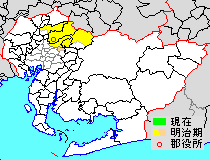
was a district located on the northeastern Owari Region in Aichi, Japan. History Historically the district formerly included most of the current cities of Komaki, Kasugai, Seto, and Owariasahi. District Timeline * February 5, 1880 - Kasugai District was split off into Higashikasugai and Nishikasugai Districts during the early Meiji period establishment of the municipalities system, which initially consisted of 109 villages. Its district headquarters was located at the village of Kachigawa (Katsukawa). * October 1, 1889 - With the establishment of the municipalities system in effect, Higashikasugai District consisted of one town and 40 villages. * April 1, 1891 - The establishment of the district/county system was implemented. * January 29, 1892 - The village of Seto gained town status. (2 towns, 39 villages) * October 24, 1892 - Parts of the village of Kokorozashidan (Shidan) he section of Kamishidamisplit off to become the village of Kamishidami. (2 towns, 40 vil ... [...More Info...] [...Related Items...] OR: [Wikipedia] [Google] [Baidu] |
Districts Of Japan
In Japan, a is composed of one or more rural municipalities (Towns of Japan, towns or Villages of Japan, villages) within a Prefectures of Japan, prefecture. Districts have no governing function, and are only used for geographic or statistical purposes such as mailing addresses. Cities of Japan, Cities are not part of districts. Historically, districts have at times functioned as an administrative unit in Japan, administrative unit. From 1878 to 1921The governing law, the district code (''gunsei'', 郡制Entry for the 1890 originalanentry for the revised 1899 ''gunsei''in the National Diet Library ''Nihon hōrei sakuin''/"Index of Japanese laws and ordinances"), was abolished in 1921, but the district assemblies (''gunkai'', 郡会) existed until 1923, the district chiefs (''gunchō'', 郡長) and district offices (''gun-yakusho'', 郡役所) until 1926. district governments were roughly equivalent to a County (United States), county of the United States, ranking below Prefectu ... [...More Info...] [...Related Items...] OR: [Wikipedia] [Google] [Baidu] |
Owari Province
was a province of Japan in the area that today forms the western half of Aichi Prefecture, including the modern city of Nagoya. The province was created in 646. Owari bordered on Mikawa, Mino, and Ise Provinces. Owari and Mino provinces were separated by the Sakai River, which means "border river." The province's abbreviated name was . Owari is classified as one of the provinces of the Tōkaidō. Under the '' Engishiki'' classification system, Owari was ranked as a "superior country" (上国) and a "near country" (近国), in relation to its distance from the capital. History Owari is mentioned in records of the Nara period, including the '' Kujiki'', although the area has been settled since at least the Japanese Paleolithic period, as evidenced by numerous remains found by archaeologists. Early records mention a powerful “Owari clan”, vaguely related to, or allied with the Yamato clan, who built massive kofun burial mounds in several locations within the prov ... [...More Info...] [...Related Items...] OR: [Wikipedia] [Google] [Baidu] |
Aichi Prefecture
is a Prefectures of Japan, prefecture of Japan located in the Chūbu region of Honshū. Aichi Prefecture has a population of 7,461,111 () and a geographic area of with a population density of . Aichi Prefecture borders Mie Prefecture to the west, Gifu Prefecture and Nagano Prefecture to the north, and Shizuoka Prefecture to the east. Nagoya is the capital and largest city of the prefecture. Overview Nagoya is the capital and largest city of Aichi Prefecture, and the Largest cities in Japan by population by decade, fourth-largest city in Japan. Other major cities include Toyota, Aichi, Toyota, Okazaki, Aichi, Okazaki, and Ichinomiya, Aichi, Ichinomiya. Aichi Prefecture and Nagoya form the core of the Chūkyō metropolitan area, the List of metropolitan areas in Japan, third-largest metropolitan area in Japan and one of the largest metropolitan areas in the world. Aichi Prefecture is located on Japan's Pacific Ocean coast and forms part of the Tōkai region, a subregion of the ... [...More Info...] [...Related Items...] OR: [Wikipedia] [Google] [Baidu] |
Japan
Japan is an island country in East Asia. Located in the Pacific Ocean off the northeast coast of the Asia, Asian mainland, it is bordered on the west by the Sea of Japan and extends from the Sea of Okhotsk in the north to the East China Sea in the south. The Japanese archipelago consists of four major islands—Hokkaido, Honshu, Shikoku, and Kyushu—and List of islands of Japan, thousands of smaller islands, covering . Japan has a population of over 123 million as of 2025, making it the List of countries and dependencies by population, eleventh-most populous country. The capital of Japan and List of cities in Japan, its largest city is Tokyo; the Greater Tokyo Area is the List of largest cities, largest metropolitan area in the world, with more than 37 million inhabitants as of 2024. Japan is divided into 47 Prefectures of Japan, administrative prefectures and List of regions of Japan, eight traditional regions. About three-quarters of Geography of Japan, the countr ... [...More Info...] [...Related Items...] OR: [Wikipedia] [Google] [Baidu] |
Aichi HigashiKasugai-gun
is a prefecture of Japan located in the Chūbu region of Honshū. Aichi Prefecture has a population of 7,461,111 () and a geographic area of with a population density of . Aichi Prefecture borders Mie Prefecture to the west, Gifu Prefecture and Nagano Prefecture to the north, and Shizuoka Prefecture to the east. Nagoya is the capital and largest city of the prefecture. Overview Nagoya is the capital and largest city of Aichi Prefecture, and the fourth-largest city in Japan. Other major cities include Toyota, Okazaki, and Ichinomiya. Aichi Prefecture and Nagoya form the core of the Chūkyō metropolitan area, the third-largest metropolitan area in Japan and one of the largest metropolitan areas in the world. Aichi Prefecture is located on Japan's Pacific Ocean coast and forms part of the Tōkai region, a subregion of the Chūbu region and Kansai region. Aichi Prefecture is home to the Toyota Motor Corporation. Aichi Prefecture had many locations with the Higashiyama Zoo and ... [...More Info...] [...Related Items...] OR: [Wikipedia] [Google] [Baidu] |
Komaki, Aichi
is a city located in Aichi Prefecture, Japan. , the city had an estimated population of 148,872 in 68,174 households, and a population density of . The total area of the city was . Komaki is commonly associated with the former Komaki Airport, which is located on the border between Komaki and neighboring Kasugai. Geography Komaki is located in the middle of the Nōbi Plain, west-central Aichi Prefecture, north of the Nagoya metropolis. The city skyline is dominated by Mount Komaki, which is topped with Komaki Castle. Climate The city has a climate characterized by hot and humid summers, and relatively mild winters (Köppen climate classification ''Cfa''). The average annual temperature in Komaki is . The average annual rainfall is with September as the wettest month. The temperatures are highest on average in August, at around , and lowest in January, at around . Demographics Per Japanese census data, the population of Komaki has increased rapidly over the past 60 years. ... [...More Info...] [...Related Items...] OR: [Wikipedia] [Google] [Baidu] |
Kasugai, Aichi
is a city in Aichi Prefecture, Japan. , the city had an estimated population of 306,764, and a population density of 3,306 persons per km2. The total area of the city is . The city is sometimes called Owarikasugai to avoid confusion with other municipality of the same name, including Kasugai (now part of Fuefuki) in Yamanashi Prefecture. Geography Kasugai is located in northwest Aichi Prefecture, north of the Nagoya metropolis, in the northern Nōbi Plain. The Shōnai River flows through the southern portion of the city. Climate The city has a climate characterized by hot and humid summers, and relatively mild winters (Köppen climate classification ''Cfa''). The average annual temperature in Kasugai is 15.8 °C. The average annual rainfall is 1681 mm with September as the wettest month. The temperatures are highest on average in August, at around 28.2 °C, and lowest in January, at around 4.3 °C. Demographics Per Japanese census data, the population o ... [...More Info...] [...Related Items...] OR: [Wikipedia] [Google] [Baidu] |
Seto, Aichi
is a Cities of Japan, city in Aichi Prefecture, Japan. , the city had an estimated population of 127,659 in 56,573 households, and a population density of 1,146 persons per km2. The total area was . Geography Seto is located in the hilly northern region of Aichi Prefecture, bordering Gifu Prefecture, approximately 35 minutes from Nagoya by way of the Meitetsu Seto Line. In English, the name of "Seto" translates to "the place where the river runs quickly". However, while there is a river in Seto, it is neither significantly large nor quick-moving. The city of Seto is famous for its pottery and ceramics, so much so that the generic word for ceramics in Japanese is . The main street along the river is lined with dozens of pottery shops. Every third Saturday and Sunday in September, there is a very large pottery festival called Setomono Matsuri(瀬戸物祭り) This festival attracts about 20,000 visitors from around Japan and abroad every year. Climate The city has a climate charac ... [...More Info...] [...Related Items...] OR: [Wikipedia] [Google] [Baidu] |
Owariasahi, Aichi
is a city located in Aichi Prefecture, Japan. , the city had an estimated population of 81,954 in 35,583 households, and a population density of 3,897 persons per km². The total area of the city is . Geography Owariasahi is located in west-central Aichi Prefecture, north of the Nagoya metropolis. The Aichi Prefectural Forest Park covers approximately 15% of its area. Climate The city has a climate characterized by hot and humid summers, and relatively mild winters (Köppen climate classification ''Cfa''). The average annual temperature in Owariasahi is 15.5 °C. The average annual rainfall is 1665 mm with September as the wettest month. The temperatures are highest on average in August, at around 28.0 °C, and lowest in January, at around 4.0 °C. Demographics Per Japanese census data, the population of Owariasahi has been increasing rapidly over the past 50 years. Surrounding municipalities ;Aichi Prefecture * Nagakute *Nagoya ( Moriyama-ku) * Seto Hi ... [...More Info...] [...Related Items...] OR: [Wikipedia] [Google] [Baidu] |
Kasugai District, Owari
Kasugai may refer to: * Kasugai, Aichi is a city in Aichi Prefecture, Japan. , the city had an estimated population of 306,764, and a population density of 3,306 persons per km2. The total area of the city is . The city is sometimes called Owarikasugai to avoid confusion with other mu ..., a city in Japan * Kasugai, Yamanashi, a town in Japan * Kasugai (snack company), a Japanese snack company * Kasugai Station (other) * Nishikasugai {{disambiguation ... [...More Info...] [...Related Items...] OR: [Wikipedia] [Google] [Baidu] |
Nishikasugai District, Aichi
is a district located on the central Owari Region in Aichi Prefecture, Japan. As of October 1, 2019, the district has a population of 15,630 with a density of 2,529 per km2. The total area is 6.18 km2. Municipalities The district consists of one town: * Toyoyama ;Notes: Description During the old days, the district extended as far as Nagoya Castle, but since Taisho Era to the 1950s, most of the areas were merged into the city of Nagoya. As of the early 2000s, there were proposals to turn the entire district into a city but the merger was killed due to differences of opinion. History District Timeline * February 5, 1880 – Kasugai District was split off into Higashikasugai and Nishikasugai Districts during the early Meiji period establishment of the municipalities system, which initially consisted of 2 towns and 81 villages. Its district headquarters was located at the village of Shimootai. * October 1, 1889 – With the establishment of the municipalities sy ... [...More Info...] [...Related Items...] OR: [Wikipedia] [Google] [Baidu] |


