|
George Grenfell
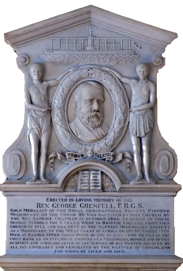
George Grenfell (21 August 1849, in Sancreed, Cornwall – 1 July 1906, in Basoko, Congo Free State (now the Democratic Republic of the Congo) was a Cornish missionary and explorer. Early years Grenfell was born at Sancreed, near Penzance, Cornwall. After the family moved to Birmingham he was educated at a branch of King Edward's school. Though his parents were Anglicans he soon joined Heneage Street Baptist Chapel, where he was admitted to membership by baptism on 7 Nov.1864. Influenced by the likes of David Livingstone, Grenfell's ambition was to become a missionary so in September 1873 he entered the Baptist College, Stokes Croft, Bristol. On 10 Nov. 1874 the Baptist Missionary Society accepted him for work in Africa. In 1875, he went as a Baptist missionary to Cameroon, West Africa, with Alfred Saker (1814–80). In 1877 he relocated to Victoria and explored the Wouri River and in the following year he ascended Mongo ma Loba Mountain. From 1880 onwards he did ... [...More Info...] [...Related Items...] OR: [Wikipedia] [Google] [Baidu] |
Sancreed
Sancreed (''Cornish: Eglossankres'') is a village and civil parish in Cornwall, England, approximately three miles (5 km) west of Penzance. Sancreed civil parish encompasses the settlements of Bejouans, Bosvennen, Botreah, Drift, Sancreed Churchtown, Trenuggo, and Tregonnebris. It is bounded by St Just parish to the west, Madron parish to the northeast, and St Buryan and Paul parishes to the south. The parish comprises of land including Drift Reservoir, which provides drinking water for the area. Geography Sancreed (Cornish: Eglossankres) is an inland parish in the former Hundred of Penwith, about three miles from Penzance. The civil parish encompasses the settlements of Bejouans, Bosvennen, Botreath, Drift, Sancreed Churchtown, Trenuggo and Tregonnebris. It is bounded by St Just to the west, Madron parish to the north-east and St Buryan and Paul parishes to the south. Within the parish is a noteworthy prehistoric settlement at Carn Euny. A few hundred metres west of ... [...More Info...] [...Related Items...] OR: [Wikipedia] [Google] [Baidu] |
Wouri River
The Wouri (also Vouri or Vuri) is a river in Cameroon. Cameroon has two major rivers, the Sanaga, the longest at about 525 km (325 miles) long and the Wouri, the largest. The Wouri forms at the confluence of the rivers Nkam and Makombé, northeast of the city of Yabassi. It then flows about southeast to the Wouri estuary at Douala, the chief port and industrial city in the southwestern part of Cameroon on the Gulf of Guinea. The river is navigable about upriver from Douala. Exploration The Portuguese navigator and explorer Fernão do Pó or Fernando Pó, is believed to be the first European to explore the estuary of the Wouri, around the year 1472. The explorers noted an abundance of the mud lobster ''Lepidophthalmus turneranus'' in the Wouri River and named it "''Rio dos Camarões"'', Portuguese for "River of Prawns", and the phrase from which the name Cameroon derived. The phrase "''Rio dos Camarões"'' later became Camarones when the Spanish arrived in the region. ... [...More Info...] [...Related Items...] OR: [Wikipedia] [Google] [Baidu] |
Kwango River
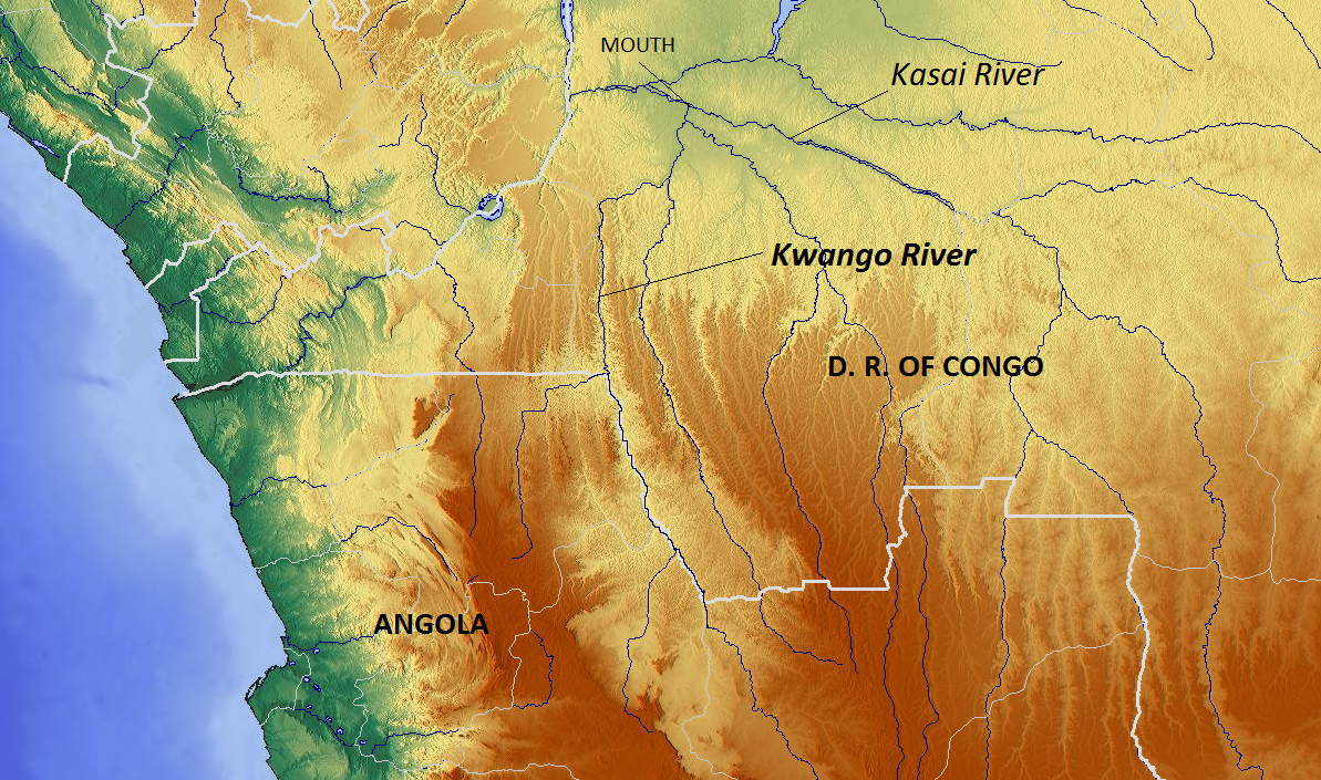
The Cuango or Kwango ( pt, Rio Cuango) is a transboundary river of Angola and Democratic Republic of Congo. It is the largest left bank tributary of the Kasai River in the Congo River basin. It flows through Malanje in Angola. The Kwango River basin has large resources of diamonds in the Chitamba-Lulo Kimberlite Cluster in Lunda Norte Province, discovered in the main river channel and on flats and terraces in its flood plains. History The Rund Kingdom, which expanded to become the Lunda Empire, encompassed territory stretching from Kwango River to the Luapula River. Its rulers partook in the slave trade. Lunda's expansion in the valley promoted a common political and cultural heritage while also promoting slave trading, accounting for the low population densities between the Kwango and Kwilu rivers.Ogot, p.607 The Portuguese colonized the Kwango River valley and usurped the Kingdom of Kasanje. The Kwango River was subject to a Portuguese treaty signing in Lisbon on May 25, 1 ... [...More Info...] [...Related Items...] OR: [Wikipedia] [Google] [Baidu] |
Kivu River
Kivu was the name for a large "region" in the Democratic Republic of the Congo under the rule of Mobutu Sese Seko that bordered Lake Kivu. It included three "Sub-Regions" ("Sous-Régions" in French): Nord-Kivu, Sud-Kivu and Maniema, corresponding to the three current provinces created in 1986. The capital of the Kivu Region was in Bukavu, and the capitals of the three Sub-Regions were in Goma, Uvira and Kindu. Kivu has been repeatedly subjected to major conflicts since the early 20th century. Under Belgian colonial rule, it was the site of several religious revolts such as the 1944 Kivu uprising. Following independence, it was a battleground of the Simba rebellion, First Congo War, and Second Congo War, and has been the site of an ongoing military conflict since the early 2000s. In addition, an Ebola epidemic affected the region from August 2018 to June 2020. Geography Kivu is also the name for the entire region surrounding Lake Kivu, including the portions in Rwanda which c ... [...More Info...] [...Related Items...] OR: [Wikipedia] [Google] [Baidu] |
Pool Malebo
The Pool Malebo, formerly Stanley Pool, also known as Mpumbu, Lake Nkunda or Lake Nkuna by local indigenous people in pre-colonial times, is a lake-like widening in the lower reaches of the Congo River."Malebo Pool" ''''. Accessed June 2011. The river serves as the border between the on the north and the Democratic Republic of the Congo
[...More Info...] [...Related Items...] OR: [Wikipedia] [Google] [Baidu] |
Kinshasa
Kinshasa (; ; ln, Kinsásá), formerly Léopoldville ( nl, Leopoldstad), is the capital and largest city of the Democratic Republic of the Congo. Once a site of fishing and trading villages situated along the Congo River, Kinshasa is now one of the world's fastest growing megacities. The city of Kinshasa is also one of the DRC's 26 provinces. Because the administrative boundaries of the city-province cover a vast area, over 90 percent of the city-province's land is rural in nature, and the urban area occupies a small but expanding section on the western side. Kinshasa is Africa's third-largest metropolitan area after Cairo and Lagos. It is also the world's largest nominally Francophone urban area, with French being the language of government, education, media, public services and high-end commerce in the city, while Lingala is used as a ''lingua franca'' in the street. Kinshasa hosted the 14th Francophonie Summit in October 2012. Residents of Kinshasa are known as ''Kinoi ... [...More Info...] [...Related Items...] OR: [Wikipedia] [Google] [Baidu] |
Equator
The equator is a circle of latitude, about in circumference, that divides Earth into the Northern and Southern hemispheres. It is an imaginary line located at 0 degrees latitude, halfway between the North and South poles. The term can also be used for any other celestial body that is roughly spherical. In spatial (3D) geometry, as applied in astronomy, the equator of a rotating spheroid (such as a planet) is the parallel (circle of latitude) at which latitude is defined to be 0°. It is an imaginary line on the spheroid, equidistant from its poles, dividing it into northern and southern hemispheres. In other words, it is the intersection of the spheroid with the plane perpendicular to its axis of rotation and midway between its geographical poles. On and near the equator (on Earth), noontime sunlight appears almost directly overhead (no more than about 23° from the zenith) every day, year-round. Consequently, the equator has a rather stable daytime temperature throug ... [...More Info...] [...Related Items...] OR: [Wikipedia] [Google] [Baidu] |
Congo River
The Congo River ( kg, Nzâdi Kôngo, french: Fleuve Congo, pt, Rio Congo), formerly also known as the Zaire River, is the second longest river in Africa, shorter only than the Nile, as well as the second largest river in the world by discharge volume, following only the Amazon. It is also the world's deepest recorded river, with measured depths around . The Congo- Lualaba- Chambeshi River system has an overall length of , which makes it the world's ninth- longest river. The Chambeshi is a tributary of the Lualaba River, and ''Lualaba'' is the name of the Congo River upstream of Boyoma Falls, extending for . Measured along with the Lualaba, the main tributary, the Congo River has a total length of . It is the only major river to cross the Equator twice. The Congo Basin has a total area of about , or 13% of the entire African landmass. Name The name ''Congo/Kongo'' originates from the Kingdom of Kongo once located on the southern bank of the river. The kingdom in turn was name ... [...More Info...] [...Related Items...] OR: [Wikipedia] [Google] [Baidu] |
Manyanga
Manyanga was a staging post on the route from the coast to Léopoldville during the days of the Congo Free State. It was at the upper end of a navigable reach of the Congo River from Isangila, further downstream to the west. Above Manyanga goods had to be carried by land round the falls and rapids to Stanley Pool. Location The lower part of the Congo River below Stanley Pool first descends through the Livingstone Falls and rapids, then has a navigable section from Manyanga to Isangila, and then has further rapids and cataracts down to Matadi, from where it is navigable to the Atlantic Ocean. History In February 1881 Henry Morton Stanley heard rumours that English missionaries were planning to build a post in the region, and asked Louis Valcke to establish an International African Association (AIA) post at Isanghila before they did so. While Valcke continued to develop the Isanghila post, Stanley took the steamers '' En Avant'' and ''Royal'' up the navigable stretch of the river ... [...More Info...] [...Related Items...] OR: [Wikipedia] [Google] [Baidu] |
Isangila
Isangila, formerly called Isanghila or Isanguila is the headquarters of a sector of the Seke-Banza territory in Kongo Central province of the Democratic Republic of the Congo. Location The lower part of the Congo River below Stanley Pool first descends through the Livingstone Falls and rapids, then has a navigable section from Manyanga to Isangile, and then has further rapids and cataracts down to Matadi, from where it is navigable to the Atlantic Ocean. Isangila is on the right bank of the Congo River, about north and upstream from Vivi. From there the river is navigable for small steamers and whaleboats for about upstream to Manyanga. It was an important post for portage operations to Léopoldville before the construction of the Matadi-Léopoldville Railway. History In 1880 Henry Morton Stanley established stations for the International African Association at Vivi, Isanghila, Lukungo, Manyanga South and Leopoldville below Stanley Pool. Stanley returned to Vivi on 4 July ... [...More Info...] [...Related Items...] OR: [Wikipedia] [Google] [Baidu] |
Vivi, Democratic Republic Of The Congo
Vivi is a village in the Bas-Congo province of the Democratic Republic of the Congo. It is located on the north side of the Congo River, opposite the provincial capital of Matadi. It was found in 1879 by Henry Morton Stanley. It served as the first capital of the Congo Free State ''(Work and Progress) , national_anthem = Vers l'avenir , capital = Vivi Boma , currency = Congo Free State franc , religion = Catholicism (''de facto'') , leader1 = Leopo ... from July, 1885 to May 1, 1886, when the capital was relocated to Boma. References Populated places in Kongo Central {{DRCongo-geo-stub ... [...More Info...] [...Related Items...] OR: [Wikipedia] [Google] [Baidu] |


