|
Facatativá
Facatativá is a city and municipality in the Cundinamarca Department, located about 18 miles (31 km) northwest of Bogotá, Colombia and 2,586 meters above sea level. The city is known for its Archaeological Park Piedras del Tunjo (Rocks of the Tunjo Indian) and best known in Colombia as ''Piedras del Tunjo'' (literally, Rocks of Tunjo), although locals call it ''Piedras de Tunja'' (Rocks of Tunja). It features large rock formations that were once the bottom of a lake. Etymology The word Facatativá comes from the indigenous Chibcha language spoken by the Muisca who inhabited the area of Facatativá before the Spanish conquest. It has been translated and interpreted differently over time. The historically accepted translation is "fenced fort at the end of the plains" (''Cercado fuerte al final de la llanura'') although it has also been translated as "fenced fort outside the farming soil" (''Cercado fuerte a las afueras de la labranza'') [...More Info...] [...Related Items...] OR: [Wikipedia] [Google] [Baidu] |
Archaeological Park Piedras Del Tunjo
Piedras del Tunjo (Spanish for "Tunjo Rocks") is an important archaeological park established on a natural rock shelter west of Bogotá in the municipality of Facatativá. Description In the Late Pleistocene, the site used to be the shore of a large lake flooding the Bogotá savanna; Lake Humboldt .8 It was used by the Muisca rulers as a refuge during the time of the Spanish conquest. The site is one of the possible places where the soldiers of Gonzalo Jiménez de Quesada killed the ruling ''zipa'' Tisquesusa in April 1537. The rocks are covered with pictographs made by Muisca artists on rocks of the Guadalupe Group.Plancha 227, 1998 Their age has not been confirmed. The area of the park used to be an hacienda, property of a wealthy family since colonial times. It was nationalized in 1946 to establish the park. Destruction of the ancient pictographs Decades of government negligence and lack of policies for the protection of archaeological heritage have resulted in the d ... [...More Info...] [...Related Items...] OR: [Wikipedia] [Google] [Baidu] |
Muisca Art
This article describes the art produced by the Muisca. The Muisca people, Muisca established one of the four grand civilisations of the pre-Columbian era, pre-Columbian Americas on the Altiplano Cundiboyacense in present-day central Colombia. Their various forms of art have been described in detail and include pottery, textiles, body art, hieroglyphs and rock art. While their architecture was modest compared to the Inca Empire, Inca, Aztec Empire, Aztec and Maya civilization, Maya civilisations, the Muisca are best known for their skilled goldworking. The Gold Museum, Bogotá, Museo del Oro in the Colombian capital Bogotá houses the biggest collection of golden objects in the world, from various Colombian cultures including the Muisca. The first art in the Cordillera Oriental (Colombia), Eastern Ranges of the Colombian Andes goes back several millennia. Although this predates the Muisca civilisation, whose onset is commonly set at 800 AD, nevertheless, some of these styles perse ... [...More Info...] [...Related Items...] OR: [Wikipedia] [Google] [Baidu] |
Spanish Conquest Of The Muisca
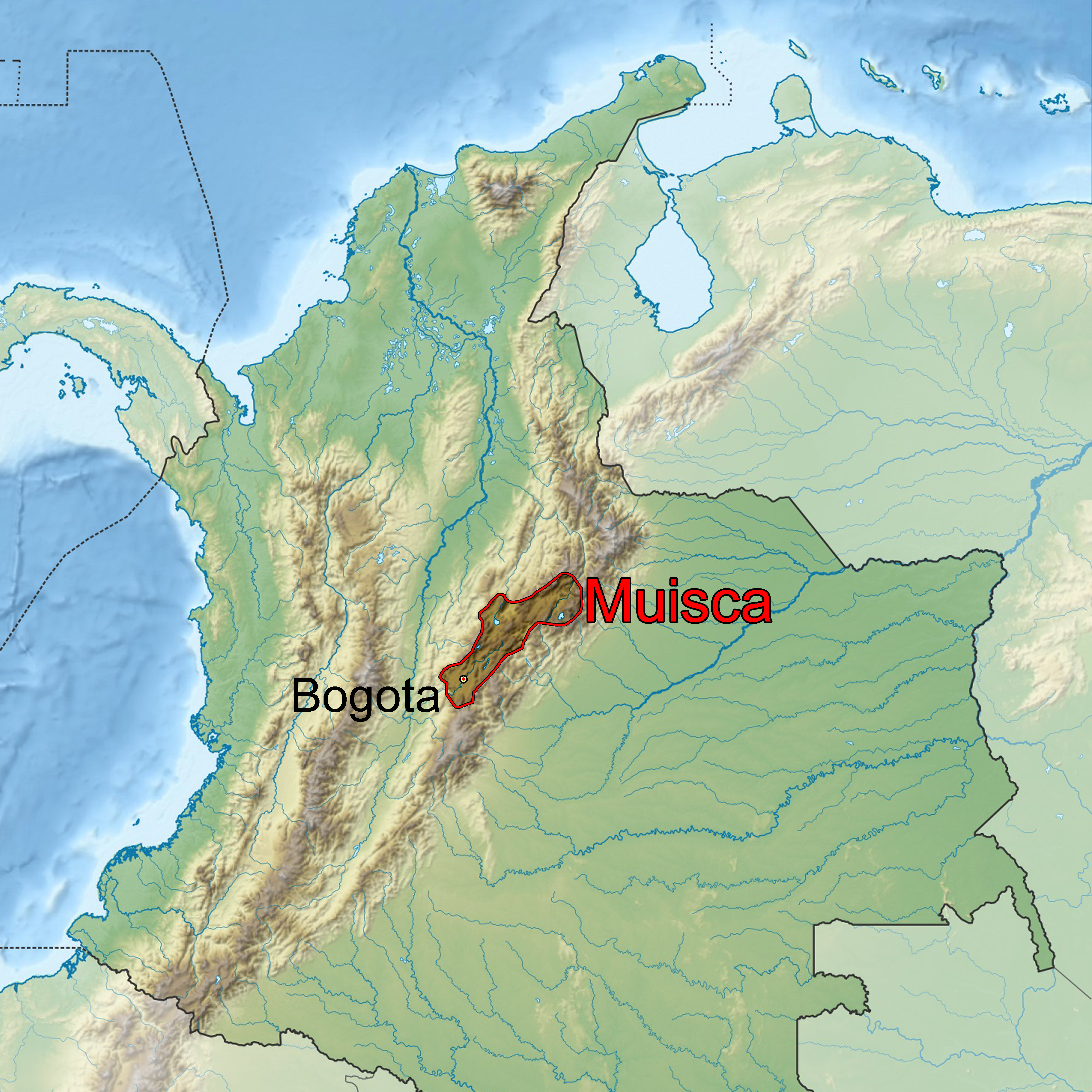
The Spanish conquest of the Muisca took place from 1537 to 1540. The Muisca people, Muisca were the inhabitants of the central Andes, Andean highlands of Colombia before the arrival of the Spanish conquistadors. They were organised in a loose Muisca Confederation, confederation of different Muisca rulers, rulers; the ''zipa, psihipqua'' of Bacatá, Muyquytá, with his headquarters in Funza, the ''zaque, hoa'' of Tunja, Hunza, the ''iraca'' of the sacred City of the Sun Sogamoso, Sugamuxi, the Tundama of Duitama, Tundama, and several other independent ''caciques''. The most important rulers at the time of the conquest were ''psihipqua'' Tisquesusa, ''hoa'' Quemuenchatocha, Eucaneme, ''iraca'' Sugamuxi and Tundama in the northernmost portion of their territories. The Muisca were organised in small communities of circular enclosures (''ca'' in their language Chibcha language, Muysccubbun; literally "language of the people"), with a central square where the ''Muisca architecture, boh ... [...More Info...] [...Related Items...] OR: [Wikipedia] [Google] [Baidu] |
Bogotá Savanna
The Bogotá savanna is a savanna#Savanna ecoregions, montane savanna, located in the southwestern part of the Altiplano Cundiboyacense in the center of Colombia. The Bogotá savanna has an extent of and an average altitude of . The savanna is situated in the Cordillera Oriental (Colombia), Eastern Ranges of the Colombian Andes. The Bogotá savanna is crossed from northeast to southwest by the long Bogotá River, which at the southwestern edge of the plateau forms the Tequendama Falls (''Salto del Tequendama''). Other rivers, such as the Subachoque River, Subachoque, Bojacá River, Bojacá, Fucha River, Fucha, Soacha River, Soacha and Tunjuelo Rivers, tributaries of the Bogotá River, form smaller valleys with very fertile soils dedicated to agriculture and cattle-breeding. Before the Spanish conquest of the Muisca, Spanish conquest of the Bogotá savanna, the area was inhabited by the indigenous Muisca people, Muisca, who formed a loose confederation of various ''caciques'', na ... [...More Info...] [...Related Items...] OR: [Wikipedia] [Google] [Baidu] |
Cundinamarca Department
Department of Cundinamarca (, ) is one of the departments of Colombia. Its area covers (not including the Capital District) and it has a population of 2,919,060 as of 2018. It was created on August 5, 1886, under the constitutional terms presented on the same year. Cundinamarca is located in the center of Colombia. Cundinamarca's capital city is Bogotá, the capital of Colombia. This is a special case among Colombian departments, since List of capitals outside the territories they serve, Bogotá is not legally a part of Cundinamarca, yet it is the only department that has its capital designated by the Colombian Constitution of 1991, Constitution (if the capital were to be ever moved, it would take a constitutional reform to do so, instead of a simple ordinance passed by the Cundinamarca Assembly). In censuses, the populations for Bogotá and Cundinamarca are tabulated separately; otherwise, Cundinamarca's population would total over 11 million. Etymology The name of Cundin ... [...More Info...] [...Related Items...] OR: [Wikipedia] [Google] [Baidu] |
Western Savanna Province
Western Savanna Province is one of the 15 provinces in the Cundinamarca Department, Colombia Colombia, officially the Republic of Colombia, is a country primarily located in South America with Insular region of Colombia, insular regions in North America. The Colombian mainland is bordered by the Caribbean Sea to the north, Venezuel .... Subdivision The Western Savanna province is subdivided into 8 municipalities:Orden en las provincias de Cundinamarca - El Tiempo References Provinces of Cundinamarca Department {{Cundinamarca-geo-stub ...[...More Info...] [...Related Items...] OR: [Wikipedia] [Google] [Baidu] |
Tisquesusa
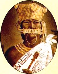
Tisquesusa, also spelled Thisquesuza, Thysquesuca or Thisquesusha (referred to in the earliest sources as Bogotá, the Elder) (died Facatativá, 1537) was the fourth and last independent ruler ('' psihipqua'') of Muyquytá, main settlement of the southern Muisca between 1514 and his death in 1537. The Spanish pronunciation of his name brought about the Colombian capital Bogotá. Tisquesusa was the ruler of the southern Muisca Confederation at the time of the Spanish conquest of the Muisca, when the troops led by Gonzalo Jiménez de Quesada and his brother entered the central Andean highlands. Biography Tisquesusa was ''cacique'' of Chía and following the Muisca heritage rules, he, as nephew of the previous ruler Nemequene, succeeded his uncle in 1514. At the start of his reign, Tisquesusa fought against the Panche in the west of the Muisca Confederation. The brother of Tisquesusa and later -according to Muisca heritage rule illegal- successor Sagipa was the general in ... [...More Info...] [...Related Items...] OR: [Wikipedia] [Google] [Baidu] |
Herrera Period
The Herrera Period is a phase in the history of Colombia. It is part of the Andean preceramic and ceramic, time equivalent of the North American pre-Columbian era, pre-Columbian Formative stage, formative and classic stages and age dated by various archaeologists. The Herrera Period predates the age of the Muisca people, Muisca, who inhabited the Altiplano Cundiboyacense before the Spanish conquest of the Muisca and postdates the Muisca Confederation#Prehistory, prehistory of the region in Colombia. The Herrera Period is usually defined as ranging from 800 BCE to 800 CE, although some scholars date it as early as 1500 BCE. Ample evidence of the Herrera Period has been uncovered on the Altiplano Cundiboyacense. The main archaeologists contributing to the present knowledge about the Herrera Period are the List of Muisca scholars, scholars Ana María Groot, Gonzalo Correal Urrego, Thomas van der Hammen, Carl Henrik Langebaek Rueda, Sylvia M. Broadbent, and Marianne Cardale de Schri ... [...More Info...] [...Related Items...] OR: [Wikipedia] [Google] [Baidu] |
Muisca People
The Muisca (also called the Chibcha) are indigenous peoples in Colombia and were a Pre-Columbian culture of the Altiplano Cundiboyacense that formed the Muisca Confederation before the Spanish colonization of the Americas. The Muisca speak Muysccubun, a language of the Chibchan language family, also called ''Muysca'' and ''Mosca''. The first known contact with Europeans in the region was in 1537 during the Spanish conquest of New Granada. In New Spain, Spanish clerics and civil officials had a major impact on the Muisca, attempting to Christianize and incorporate them into the Spanish Empire as subjects. Postconquest Muisca culture underwent significant changes due to the establishment of the New Kingdom of Granada. Sources for the Muisca are far less abundant than for the Aztec Empire of Mesoamerica or the Inca Empire and their incorporation to the Spanish Empire during the colonial era. In the New Kingdom of Granada and into the colonial era, the Muisca became " ... [...More Info...] [...Related Items...] OR: [Wikipedia] [Google] [Baidu] |
Municipalities Of Colombia
The municipalities of Colombia are decentralized subdivisions of the Colombia, Republic of Colombia. Municipalities make up most of the departments of Colombia, with 1,104 municipality, municipalities (''municipios''). Each one of them is led by a mayor (''alcalde'') elected by popular vote and represents the maximum executive government official at a municipality level under the mandate of the governor of their department which is a representative of all municipalities in the department; municipalities are grouped to form departments. The municipalities of Colombia are also grouped in an association called the ''Federación Colombiana de Municipios'' (Colombian Federation of Municipalities), which functions as a union under the private law and under the Colombian Constitution of 1991, constitutional Freedom of association, right to free association to defend their common interests. Categories Conforming to the law 1551/12 that modified the sixth article of the law 136/94 Art ... [...More Info...] [...Related Items...] OR: [Wikipedia] [Google] [Baidu] |
Earthquake
An earthquakealso called a quake, tremor, or tembloris the shaking of the Earth's surface resulting from a sudden release of energy in the lithosphere that creates seismic waves. Earthquakes can range in intensity, from those so weak they cannot be felt, to those violent enough to propel objects and people into the air, damage critical infrastructure, and wreak destruction across entire cities. The seismic activity of an area is the frequency, type, and size of earthquakes experienced over a particular time. The seismicity at a particular location in the Earth is the average rate of seismic energy release per unit volume. In its most general sense, the word ''earthquake'' is used to describe any seismic event that generates seismic waves. Earthquakes can occur naturally or be induced by human activities, such as mining, fracking, and nuclear weapons testing. The initial point of rupture is called the hypocenter or focus, while the ground level directly above it is the ... [...More Info...] [...Related Items...] OR: [Wikipedia] [Google] [Baidu] |


