|
Eyewall
The eye is a region of mostly calm weather at the center of a tropical cyclone. The eye of a storm is a roughly circular area, typically in diameter. It is surrounded by the eyewall, a ring of towering thunderstorms where the most severe weather and highest winds of the cyclone occur. The cyclone's lowest barometric pressure occurs in the eye and can be as much as 15 percent lower than the pressure outside the storm. In strong tropical cyclones, the eye is characterized by light winds and clear skies, surrounded on all sides by a towering, symmetric eyewall. In weaker tropical cyclones, the eye is less well defined and can be covered by the central dense overcast, an area of high, thick clouds that show up brightly on satellite imagery. Weaker or disorganized storms may also feature an eyewall that does not completely encircle the eye or have an eye that features heavy rain. In all storms, however, the eye is where the barometer reading is lowest. Structure A typical tropic ... [...More Info...] [...Related Items...] OR: [Wikipedia] [Google] [Baidu] |
Tropical Cyclone
A tropical cyclone is a rapidly rotating storm system with a low-pressure area, a closed low-level atmospheric circulation, strong winds, and a spiral arrangement of thunderstorms that produce heavy rain and squalls. Depending on its location and strength, a tropical cyclone is called a hurricane (), typhoon (), tropical storm, cyclonic storm, tropical depression, or simply cyclone. A hurricane is a strong tropical cyclone that occurs in the Atlantic Ocean or northeastern Pacific Ocean. A typhoon is the same thing which occurs in the northwestern Pacific Ocean. In the Indian Ocean and South Pacific, comparable storms are referred to as "tropical cyclones". In modern times, on average around 80 to 90 named tropical cyclones form each year around the world, over half of which develop hurricane-force winds of or more. Tropical cyclones tropical cyclogenesis, typically form over large bodies of relatively warm water. They derive their energy through the evaporation of water ... [...More Info...] [...Related Items...] OR: [Wikipedia] [Google] [Baidu] |
Annular Hurricane
An annular tropical cyclone is a tropical cyclone that features a normal to large, symmetric eye surrounded by a thick and uniform ring of intense convection, often having a relative lack of discrete rainbands, and bearing a symmetric appearance in general. As a result, the appearance of an annular tropical cyclone can be referred to as akin to a tire or doughnut. Annular characteristics can be attained as tropical cyclones intensify; however, outside the processes that drive the transition from asymmetric systems to annular systems and the abnormal resistance to negative environmental factors found in storms with annular features, annular tropical cyclones behave similarly to asymmetric storms. Most research related to annular tropical cyclones is limited to satellite imagery and aircraft reconnaissance as the conditions thought to give rise to annular characteristics normally occur over open water, well removed from landmasses where surface observations are possible. Ch ... [...More Info...] [...Related Items...] OR: [Wikipedia] [Google] [Baidu] |
Hurricane Isabel
Hurricane Isabel was a Category 5 Atlantic hurricane that struck the east coast of the United States in September 2003. The ninth named storm, fifth hurricane, and second major hurricane of the season, Isabel formed in the eastern Atlantic Ocean on September 6 from a tropical wave. It moved northwestward through an area with light wind shear and warm waters, resulting in strengthening. Isabel reached peak winds of on September 11. After fluctuating in intensity for four days, Isabel gradually weakened and made landfall on the Outer Banks of North Carolina, with winds of on September 18, or a Category 2 on the Saffir-Simpson scale. Isabel quickly weakened over land and became extratropical over western Pennsylvania on the next day. On September 20, the extratropical remnants of Isabel were absorbed into another system over Eastern Canada. In North Carolina, the storm surge from Isabel washed out a portion of Hatteras Island to form what was unofficially known ... [...More Info...] [...Related Items...] OR: [Wikipedia] [Google] [Baidu] |
Central Dense Overcast
The central dense overcast, or CDO, of a tropical cyclone or strong subtropical cyclone is the large central area of thunderstorms surrounding its circulation center, caused by the formation of its eyewall. It can be round, angular, oval, or irregular in shape. This feature shows up in tropical cyclones of tropical storm or hurricane strength. How far the center is embedded within the CDO, and the temperature difference between the cloud tops within the CDO and the cyclone's eye, can help determine a tropical cyclone's intensity with the Dvorak technique. Locating the center within the CDO can be a problem with strong tropical storms and minimal hurricanes as its location can be obscured by the CDO's high cloud canopy. This center location problem can be resolved through the use of microwave satellite imagery. After a cyclone strengthens to around hurricane intensity, an eye appears at the center of the CDO, defining its center of low pressure and its cyclonic wind field. Tropi ... [...More Info...] [...Related Items...] OR: [Wikipedia] [Google] [Baidu] |
Hurricane Hunters
Hurricane hunters, typhoon hunters, or cyclone hunters are aircrews that fly into tropical cyclones to gather weather data. In the United States, the organizations that fly these missions are the United States Air Force Reserve's 53rd Weather Reconnaissance Squadron and the National Oceanic and Atmospheric Administration's Hurricane Hunters. Such missions have also been flown by Navy units and other Air Force and NOAA units. Other organizations also fly these missions, such as Government Flying Service Hong Kong. The first crewed flight into a hurricane happened in 1943 when a pilot-trainer flew into a Category 1 hurricane near Galveston, Texas on a bet. In the past, before satellites were used to find tropical storms, military aircraft flew routine weather reconnaissance tracks to detect formation of tropical cyclones. While modern satellites have improved the ability of meteorologists to detect cyclones before they form, only aircraft are able to measure the interior ba ... [...More Info...] [...Related Items...] OR: [Wikipedia] [Google] [Baidu] |
Dvorak Technique
The Dvorak technique (developed between 1969 and 1984 by Vernon Dvorak) is a widely used system to estimate tropical cyclone intensity (which includes tropical depression, tropical storm, and hurricane/typhoon/intense tropical cyclone intensities) based solely on visible and infrared Weather satellite, satellite images. Within the Dvorak satellite strength estimate for tropical cyclones, there are several Pattern recognition, visual patterns that a cyclone may take on which define the upper and lower bounds on its intensity. The primary patterns used are curved rainband, band pattern (T1.0-T4.5), Wind shear#Effects on tropical cyclones, shear pattern (T1.5–T3.5), central dense overcast (CDO) pattern (T2.5–T5.0), central cold cover (CCC) pattern, banding eye pattern (T4.0–T4.5), and Eye (cyclone), eye pattern (T4.5–T8.0). Both the central dense overcast and embedded eye pattern use the size of the CDO. The CDO pattern intensities start at T2.5, equivalent to minimal trop ... [...More Info...] [...Related Items...] OR: [Wikipedia] [Google] [Baidu] |
1960 Pacific Typhoon Season
The 1960 Pacific typhoon season had no official bounds; it ran year-round in 1960, but most tropical cyclones tend to form in the northwestern Pacific Ocean between June and December. These dates conventionally delimit the period of each year when most tropical cyclones form in the northwestern Pacific Ocean. The scope of this article is limited to the Pacific Ocean, north of the equator, and west of the International Date Line. Storms that form east of the dateline and north of the equator are called hurricanes; see 1960 Pacific hurricane season. Tropical storms formed in the entire west Pacific basin were assigned a name by the Joint Typhoon Warning Center. Tropical depressions in this basin had the "W" suffix added to their number. Systems ImageSize = width:950 height:290 PlotArea = top:10 bottom:80 right:25 left:20 Legend = columns:3 left:30 top:58 columnwidth:270 AlignBars = early DateFormat = dd/mm/yyyy Period = from:01/01/1960 till:01/01/1961 TimeAxis = orientation:ho ... [...More Info...] [...Related Items...] OR: [Wikipedia] [Google] [Baidu] |
Hurricane Wilma
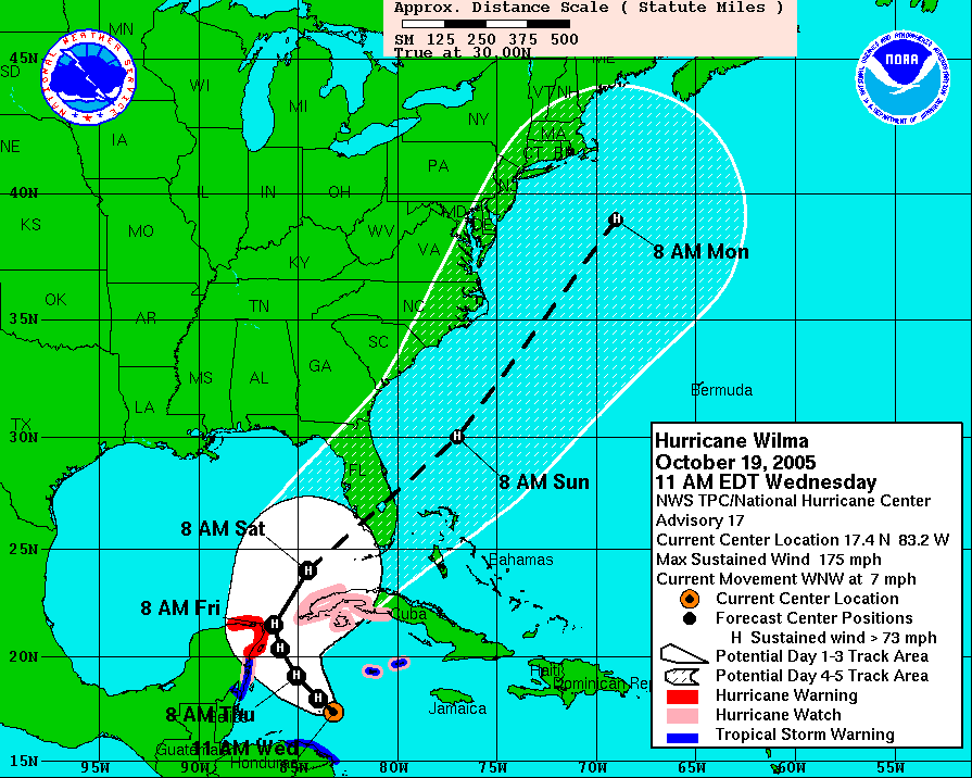
Hurricane Wilma was the most intense tropical cyclone in the Atlantic basin and the second-most intense tropical cyclone in the Western Hemisphere, both based on barometric pressure, after Hurricane Patricia in 2015. Wilma's rapid intensification led to a 24-hour pressure drop of , setting a new basin record. At its peak, Hurricane Wilma's Eye (cyclone), eye contracted to a record minimum diameter of . In the record-breaking 2005 Atlantic hurricane season, Wilma was the twenty-second storm, thirteenth hurricane, sixth major hurricane, fourth Category 5 hurricane, and the second costliest in Mexican history. Its origins came from a tropical depression that formed in the Caribbean Sea near Jamaica on October 15, headed westward, and intensified into a tropical storm two days later, which abruptly turned southward and was named Wilma. Continuing to strengthen, Wilma eventually became a hurricane on October 18. Shortly thereafter, explosive intensification occurre ... [...More Info...] [...Related Items...] OR: [Wikipedia] [Google] [Baidu] |
Weather Satellite
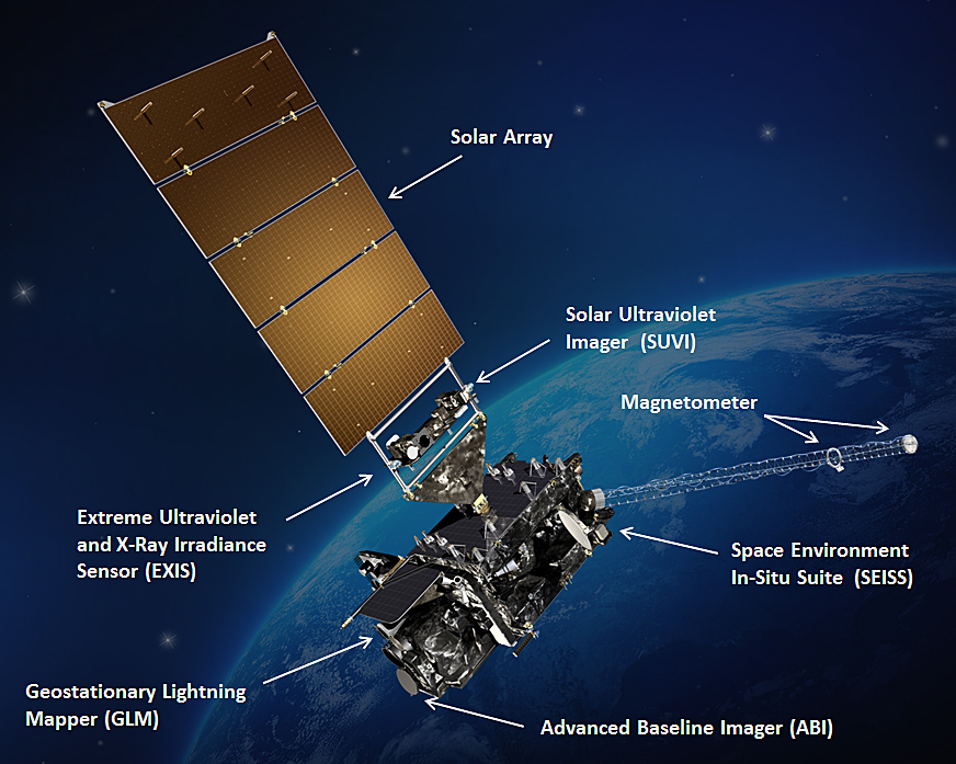
A weather satellite or meteorological satellite is a type of Earth observation satellite that is primarily used to monitor the weather and climate of the Earth. Satellites are mainly of two types: polar orbiting (covering the entire Earth asynchronously) or geostationary (hovering over the same spot on the equator). While primarily used to detect the development and movement of storm systems and other cloud patterns, meteorological satellites can also detect other phenomena such as city lights, fires, effects of pollution, auroras, sand and dust storms, snow cover, ice mapping, boundaries of ocean currents, and energy flows. Other types of environmental information are collected using weather satellites. Weather satellite images helped in monitoring the volcanic ash cloud from Mount St. Helens and activity from other volcanoes such as Mount Etna. Smoke from fires in the western United States such as Colorado and Utah have also been monitored. El Niño and its effects on wea ... [...More Info...] [...Related Items...] OR: [Wikipedia] [Google] [Baidu] |
Positive Feedback Loop
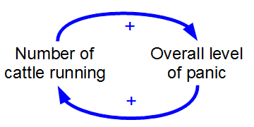
Positive feedback (exacerbating feedback, self-reinforcing feedback) is a process that occurs in a feedback loop where the outcome of a process reinforces the inciting process to build momentum. As such, these forces can exacerbate the effects of a small disturbance. That is, the effects of a perturbation on a system include an increase in the magnitude of the perturbation. That is, ''A produces more of B which in turn produces more of A''.Keesing, R.M. (1981). Cultural anthropology: A contemporary perspective (2nd ed.) p.149. Sydney: Holt, Rinehard & Winston, Inc. In contrast, a system in which the results of a change act to reduce or counteract it has negative feedback. Both concepts play an important role in science and engineering, including biology, chemistry, and cybernetics. Mathematically, positive feedback is defined as a positive loop gain around a closed loop of cause and effect. That is, positive feedback is in phase with the input, in the sense that it adds to m ... [...More Info...] [...Related Items...] OR: [Wikipedia] [Google] [Baidu] |


