|
Esguerra-Bárcenas Treaty
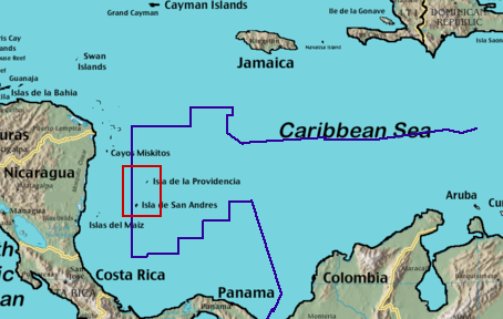
The Esguerra-Bárcenas Treaty was signed between Colombia and Nicaragua on 24 March 1928. Under the terms of the treaty, Nicaragua recognized Colombia's sovereignty over the Archipelago of San Andrés, Providencia and Santa Catalina. Colombia recognized Nicaragua's sovereignty over the Coast of Mosquitos. This treaty is heavily criticized by the Nicaraguan government as it was signed during the United States occupation of Nicaragua. In 2001, Nicaragua declared that they disputed the agreement and filed a formal complaint before the International Court of Justice in The Hague, claiming maritime boundaries east of longitude 82 of Greenwich, whilst disputing sovereignty over parts of the archipelago of San Andrés. On December 13, 2007, the International Court of Justice recognized the full sovereignty of Colombia over the islands of San Andrés, Providencia and Santa Catalina, and recognized Colombian sovereignty over the cays of Serranilla, Quitasueño, Serrana, Roncador and Ba ... [...More Info...] [...Related Items...] OR: [Wikipedia] [Google] [Baidu] |
Colombia
Colombia, officially the Republic of Colombia, is a country primarily located in South America with Insular region of Colombia, insular regions in North America. The Colombian mainland is bordered by the Caribbean Sea to the north, Venezuela to the east and northeast, Brazil to the southeast, Peru and Ecuador to the south and southwest, the Pacific Ocean to the west, and Panama to the northwest. Colombia is divided into 32 Departments of Colombia, departments. The Capital District of Bogotá is also the List of cities in Colombia by population, country's largest city hosting the main financial and cultural hub. Other major urban areas include Medellín, Cali, Barranquilla, Cartagena, Colombia, Cartagena, Santa Marta, Cúcuta, Ibagué, Villavicencio and Bucaramanga. It covers an area of 1,141,748 square kilometers (440,831 sq mi) and has a population of around 52 million. Its rich cultural heritage—including language, religion, cuisine, and art—reflects its history as a co ... [...More Info...] [...Related Items...] OR: [Wikipedia] [Google] [Baidu] |
Bajo Nuevo
Bajo Nuevo Bank, also known as the Petrel Islands (), is a small, uninhabited reef with some small grass-covered islets, located in the western Caribbean Sea at , with a lighthouse on Low Cay at . The closest neighboring land feature is Serranilla Bank, located to the west. The reef was first shown on Dutch maps dating to 1634 but was given its present name in 1654. Bajo Nuevo was rediscovered by the English pirate John Glover in 1660. The reef is now subject to a sovereignty dispute involving Colombia and the United States. On 19 November 2012, regarding Nicaraguan claims to the islands, the International Court of Justice (ICJ) found, unanimously, that the Republic of Colombia has sovereignty over both Bajo Nuevo and Serranilla Banks, although the judgment does not analyze or mention the competing claims of Honduras or the United States. Geography Bajo Nuevo Bank is about long and wide. The satellite image shows two distinct atoll-like structures separated by a deep channel ... [...More Info...] [...Related Items...] OR: [Wikipedia] [Google] [Baidu] |
Territorial Disputes Of Nicaragua
Territorial disputes of Nicaragua include the territorial dispute with Colombia over the Archipelago of San Andrés, Providencia and Santa Catalina and Quita Sueño Bank. Nicaragua also has a maritime boundary dispute with Honduras in the Caribbean Sea and a Costa Rica–Nicaragua San Juan River border dispute, boundary dispute over the San Juan River (Nicaragua), Rio San Juan with Costa Rica. Colombia San Andres y Providencia In 1670 the English Privateer, corsair Henry Morgan took over the islands until 1689. In 1803, after Spain's Viceroyalty of New Granada had been re-established in 1739, the archipelago and the province of Veraguas – covering the western territory of Panama and the eastern coast of Nicaragua – were added to its area of jurisdiction. In the later colonial era the territory was administered from the province of Cartagena, Colombia, Cartagena. After the Republic of Gran Colombia gained independence in 1822, the inhabitants of the islands – wh ... [...More Info...] [...Related Items...] OR: [Wikipedia] [Google] [Baidu] |
Territorial Disputes Of Colombia
A territory is an area of land, sea, or space, belonging or connected to a particular country, person, or animal. In international politics, a territory is usually a geographic area which has not been granted the powers of self-government, i.e. an area that is under the jurisdiction of a sovereign state. As a subdivision, a territory in most countries is an organized division of an area that is controlled by a country but is not formally developed into, or incorporated into, a political unit of that country, which political units are of equal status to one another and are often referred to by words such as "provinces", "regions", or "states". In its narrower sense, it is "a geographic region, such as a colonial possession, that is dependent on an external government." Etymology The origins of the word "territory" begin with the Proto-Indo-European root ''ters'' ('to dry'). From this emerged the Latin word ''terra'' ('earth, land') and later the Latin word ''territorium'' ( ... [...More Info...] [...Related Items...] OR: [Wikipedia] [Google] [Baidu] |
Colombia–Nicaragua Relations
The relationship between the Colombia and Nicaragua has evolved amid conflicts over the San Andrés y Providencia Islands located in the Caribbean Sea close to the Nicaraguan shoreline and the maritime boundaries covering 150,000 km2 that included the islands of San Andrés, Providencia and Santa Catalina and the banks of Roncador, Serrana, Serranilla and Quitasueño as well as the 82nd meridian west which Colombia claims as a border but which the International Court has sided with Nicaragua in disavowing. The sea around the archipelago has been under Colombian control since 1931 when a treaty was signed during US occupation of Nicaragua, giving Colombia control over the area. Both nations are members of the Association of Caribbean States, Community of Latin American and Caribbean States, Organization of American States, Organization of Ibero-American States and the United Nations. History War in Central America In 1985 during the Sandinista revolution in Nicaragua ... [...More Info...] [...Related Items...] OR: [Wikipedia] [Google] [Baidu] |
Treaties Concluded In 1928
A treaty is a formal, legally binding written agreement between sovereign states and/or international organizations that is governed by international law. A treaty may also be known as an international agreement, protocol, covenant, convention, pact, or exchange of letters, among other terms; however, only documents that are legally binding on the parties are considered treaties under international law. Treaties may be bilateral (between two countries) or multilateral (involving more than two countries). Treaties are among the earliest manifestations of international relations; the first known example is a border agreement between the Sumerian city-states of Lagash and Umma around 3100 BC. International agreements were used in some form by most major civilizations and became increasingly common and more sophisticated during the early modern era. The early 19th century saw developments in diplomacy, foreign policy, and international law reflected by the widespread use of treat ... [...More Info...] [...Related Items...] OR: [Wikipedia] [Google] [Baidu] |
Roncador
Roncador Bank is a mostly-submerged atoll with several sandy cays. It lies in the west Caribbean Sea off the coast of Central America. Geography It is about 15 by 6 kilometers in size, with an area of 65 km2 composed mostly of lagoon. It is in the northern area lies Roncador Cay. It also has a small coral reef. History Initially claimed by the United States under the Guano Islands Act of 1856, the atoll was ceded by the United States to Colombia on September 17, 1981, as the result of the Vásquez-Saccio Treaty (signed in 1972). There are several dilapidated houses on it built by American troops during the Cuban Missile Crisis. In 1894, the USS ''Kearsarge'' was shipwrecked on Roncador Bank. Lighthouse An old, disused lighthouse is at its northern end. A new lighthouse has been operating since 1977. See also * List of Guano Island claims A number of islands were claimed as insular areas on behalf of the United States under the Guano Islands Act of 185 ... [...More Info...] [...Related Items...] OR: [Wikipedia] [Google] [Baidu] |
Nicaragua
Nicaragua, officially the Republic of Nicaragua, is the geographically largest Sovereign state, country in Central America, comprising . With a population of 7,142,529 as of 2024, it is the third-most populous country in Central America after Guatemala and Honduras. Nicaragua is bordered by Honduras to the north, the Caribbean Sea to the east, Costa Rica to the south, and the Pacific Ocean and shares maritime borders with El Salvador to the west and Colombia to the east. The country's largest city and national capital is Managua, the List of largest cities in Central America#Largest cities proper, fourth-largest city in Central America, with a population of 1,055,247 as of 2020. Nicaragua is known as "the breadbasket of Central America" due to having the most fertile soil and arable land in all of Central America. Nicaragua's multiethnic population includes people of mestizo, indigenous, European, and African heritage. The country's most spoken language is Spanish language, ... [...More Info...] [...Related Items...] OR: [Wikipedia] [Google] [Baidu] |
Serrana Bank
Serrana Bank is a Colombian-administered atoll in the western Caribbean Sea. It is a mostly underwater reef about 50 km long and 13 km wide and has six cays, or islets, the largest of which is Southwest Cay. Geography The cays from south to north are: * Southwest Cay (500 by 200 meters) * South Cay (150 by 25 meters) * Little Cay (less than 100 meters in diameter) * East Cay (80 by 40 meters) * Narrow Cay * North Cay History Serrana Bank is believed to be named after the Spanish castaway Pedro Serrano. It was first shown on a Dutch map in 1545 with this name. They were mapped more extensively by the English in 1660. A former base for the US military, it is now mostly visited by lobster fishermen. It is now Colombian territory, though it was formerly claimed by the United States. On September 8, 1972, the two countries signed a treaty recognizing Colombia's sovereignty over Roncador Cay and Serrana Bank and abandoning American sovereignty ov ... [...More Info...] [...Related Items...] OR: [Wikipedia] [Google] [Baidu] |


