|
Enguri
The Enguri ( ka, ენგური, tr , , , ''Egry'') is a river in western Georgia (country), Georgia. It is long, and has a drainage basin of . National Statistics Office of Georgia, Tbilisi, 2020, p. 12. It originates near Ushguli in northeastern Svaneti and plays an important role in providing hydroelectric power to the area and the country.  The river emerges from the high Caucasus near the highest mountain in Georgia, Shkhara, and winds through the mountain valleys to the northwest before turning southwest to empty into the Black Sea near Anaklia. ...
[...More Info...] [...Related Items...] OR: [Wikipedia] [Google] [Baidu] |
Enguri Dam
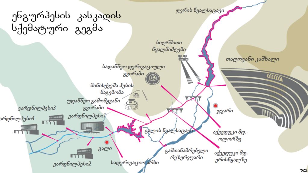
The Enguri Dam is a hydroelectric dam on the Enguri River in Tsalenjikha Municipality, Tsalenjikha, Georgia (country), Georgia. Currently, it is the world's second highest concrete arch dam, with a height of . It is located north of the town of Jvari (town), Jvari. It is part of the Enguri hydroelectric power station (HES) which is partially located in Abkhazia. History General Secretary of the Communist Party of the Soviet Union, Soviet First Secretary Nikita Khrushchev initially proposed a major dam and hydroelectric power scheme on the Bzyb River as his favourite resort was located near the mouth of the river at Pitsunda. However, his experts informed him that a dam built on the Bzyb River would have catastrophic effects in causing coastal erosion, beach erosion at Pitsunda, so in the end the dam was built on the Enguri River instead, where the impact upon the coastline was assessed to be considerably less pronounced. Construction of the Enguri dam began in 1961. The dam ... [...More Info...] [...Related Items...] OR: [Wikipedia] [Google] [Baidu] |
Enguri River With Bridge
The Enguri ( ka, ენგური, tr , , , ''Egry'') is a river in western Georgia. It is long, and has a drainage basin of . National Statistics Office of Georgia, Tbilisi, 2020, p. 12. It originates near in northeastern and plays an important role in providing power to the area and the country. [...More Info...] [...Related Items...] OR: [Wikipedia] [Google] [Baidu] |
Anaklia
Anaklia () is a town and seaside resort in western Georgia. It is located in the Samegrelo-Zemo Svaneti region, at the place where the Enguri River flows into the Black Sea. History The earliest settlement on Anaklia's territory dates back to the mid-Bronze Age and is typical to the Colchian culture. It is the Classical ''Heraclea'' of Colchis, ''Anaclia'' of later authors, and ''Anarghia'' of Archangelo Lamberti and Jean Chardin (both the 17th-century travelers). After the fragmentation of the Kingdom of Georgia in the 15th century, it was an important fortified town, sea port and fishing station within the Principality of Mingrelia. In 1723, the town was captured by the Ottoman Empire and converted into its maritime outpost and slave-trading locale. Western Georgian kingdom of Imereti regained control over Anaklia in 1770, seizing the opportunity of Ottoman Empire being at war with Russia (Russo-Turkish War (1768–1774)). Solomon I, the king of Imereti, was supposed to ... [...More Info...] [...Related Items...] OR: [Wikipedia] [Google] [Baidu] |
Mulkhura
The Mulkhra or Mulkhura ( ka, მულხრა, მულხურა) is a river in Mestia Municipality, Georgia, right tributary of the Enguri. It is located in the region Samegrelo-Zemo Svaneti, in the northwestern part of the country, northwest of the capital Tbilisi Tbilisi ( ; ka, თბილისი, ), in some languages still known by its pre-1936 name Tiflis ( ), ( ka, ტფილისი, tr ) is the Capital city, capital and List of cities and towns in Georgia (country), largest city of Georgia ( .... Length , basin area . It originates on the southern slope of the Svaneti Caucasus main ridge, on the Tviberi Glacier and joins the Enguri River near the village Kvanchianari. Mulkhura feeds on glaciers, snow, rain and groundwater.Levan Tielidze, Roman Kumlaze, Lasha AsanidzGlaciers Reduction and Climate Change Impact over the Last One Century in the Mulkhura River Basin, Caucasus Mountains, Georgia International Journal of Geosciences, 2015, 6, 465-472 Floo ... [...More Info...] [...Related Items...] OR: [Wikipedia] [Google] [Baidu] |
Black Sea
The Black Sea is a marginal sea, marginal Mediterranean sea (oceanography), mediterranean sea lying between Europe and Asia, east of the Balkans, south of the East European Plain, west of the Caucasus, and north of Anatolia. It is bounded by Bulgaria, Georgia (country), Georgia, Romania, Russia, Turkey, and Ukraine. The Black Sea is Inflow (hydrology), supplied by major rivers, principally the Danube, Dnieper and Dniester. Consequently, while six countries have a coastline on the sea, its drainage basin includes parts of 24 countries in Europe. The Black Sea, not including the Sea of Azov, covers , has a maximum depth of , and a volume of . Most of its coasts ascend rapidly. These rises are the Pontic Mountains to the south, bar the southwest-facing peninsulas, the Caucasus Mountains to the east, and the Crimean Mountains to the mid-north. In the west, the coast is generally small floodplains below foothills such as the Strandzha; Cape Emine, a dwindling of the east end ... [...More Info...] [...Related Items...] OR: [Wikipedia] [Google] [Baidu] |
Abkhaz–Georgian Conflict
The Abkhazia conflict is a territorial dispute over Abkhazia, a region on the eastern coast of the Black Sea in the South Caucasus, at the intersection of Eastern Europe and Western Asia. The conflict involves Georgia, the Russian Federation and the Russian-backed self-proclaimed Republic of Abkhazia, which is internationally recognised only by Russia, Venezuela, Nicaragua, Nauru, and Syria; Georgia and all other United Nations members consider Abkhazia a sovereign territory of Georgia.Olga Oliker, Thomas S. Szayna. Faultlines of Conflict in Central Asia and the South Caucasus: Implications for the U.S. Army. Rand Corporation, 2003, .Emmanuel Karagiannis. Energy and Security in the Caucasus. Routledge, 2002. . However, as of 2025, Georgia lacks ''de facto'' control over the territory. The beginning of the conflict dates back to the dissolution of the Soviet Union in 1991; however, the dispute can be traced to 1918—1919 Abkhazia conflict over '' Sukhumi okrug'' (which corre ... [...More Info...] [...Related Items...] OR: [Wikipedia] [Google] [Baidu] |
Ushguli
Ushguli ( ka, უშგული ) is a community of five medieval villages located at the head of the Enguri gorge in Svaneti, Georgia. Ushguli is one of the highest continuously inhabited settlements in Europe. Compared to somewhat more developed towns like Mestia, Ushguli is not in an accessible location, which has preserved many of the villages' medieval characteristics, including unique defensive tower houses called Svan towers. Anthony Bourdain: Parts Unknown9 reasons to visit Georgia now CNN, 17 May 2016 Because of their preservation and traditional architecture, Ushguli, Mestia, and the surrounding area was recognized as the ''Upper Svaneti'' UNESCO World Heritage Site in 1996. Location and features Ushguli is located at an altitude of near the foot of Shkhara, one of the highest summits of the Greater Caucasus mountains. About 70 families (about 200 people) live in the area, enough to support a small school. The area is snow-covered for 6 months of the year, and oft ... [...More Info...] [...Related Items...] OR: [Wikipedia] [Google] [Baidu] |
Main Caucasian Range
The Main Caucasian Range; is a mountain range in the Russian Federation, Georgia (country), Georgia and Azerbaijan. It is the dividing range of the Greater Caucasus. The protected areas of the range are the Teberda Nature Reserve, Kabardino-Balkaria Nature Reserve and the North Ossetia Nature Reserve. Geography The Main Caucasian Range marks the divide between the North Caucasus to the north and the South Caucasus to the south. It stretches from Mount Chugush near the Black Sea, to the Khizi District of Azerbaijan near the Caspian Sea. The main range runs parallel to the southern side of the Lateral Range, along Abkhazia, Adygea, the Krasnodar Territory, Karachay-Cherkessia, Kabardino-Balkaria, North Ossetia, Ingushetia, Chechnya and Dagestan federal subjects of Russia, as well as the countries of Georgia and Azerbaijan. The range is characterized by numerous alpine landforms and, unlike its parallel ranges to the north, it forms a continuous, uninterrupted, system of mountain r ... [...More Info...] [...Related Items...] OR: [Wikipedia] [Google] [Baidu] |
Rivers Of Georgia (country)
List of rivers of Georgia may refer to: * List of rivers of Georgia (country), a list of rivers of the country of Georgia * List of rivers of Georgia (U.S. state), a list of rivers of the American state of Georgia {{geodis ... [...More Info...] [...Related Items...] OR: [Wikipedia] [Google] [Baidu] |
Rivers Of Abkhazia
A river is a natural stream of fresh water that flows on land or inside Subterranean river, caves towards another body of water at a lower elevation, such as an ocean, lake, or another river. A river may run dry before reaching the end of its course if it runs out of water, or only flow during certain seasons. Rivers are regulated by the water cycle, the processes by which water moves around the Earth. Water first enters rivers through precipitation, whether from rainfall, the Runoff (hydrology), runoff of water down a slope, the melting of glaciers or snow, or seepage from aquifers beneath the surface of the Earth. Rivers flow in channeled watercourses and merge in confluences to form drainage basins, or catchments, areas where surface water eventually flows to a common outlet. Rivers have a great effect on the landscape around them. They may regularly overflow their Bank (geography), banks and flood the surrounding area, spreading nutrients to the surrounding area. Sedime ... [...More Info...] [...Related Items...] OR: [Wikipedia] [Google] [Baidu] |


