|
Downham Estate
The Downham Estate is a London County Council cottage estate in Downham, south east London. It is mainly in the London Borough of Lewisham and partly in the London Borough of Bromley. The Downham Estate provides an example of the programme of building council housing occurring in Britain between the First and Second World Wars. The estate was constructed between 1924 and 1930 to plans by the LCC architect George Topham Forrest. One of the first houses to be completed was ceremonially opened in 1927 by King George V. Among other similar developments around London (for example Becontree), it was developed to help alleviate the chronic shortage of housing in London, partly brought about by the complete cessation of building during World War I. It was intended to show what could be achieved by public-sector house-building: particularly in order to provide better housing for those who had lived in the slums of the city. The building of the Estate attracted subsidies from central gove ... [...More Info...] [...Related Items...] OR: [Wikipedia] [Google] [Baidu] |
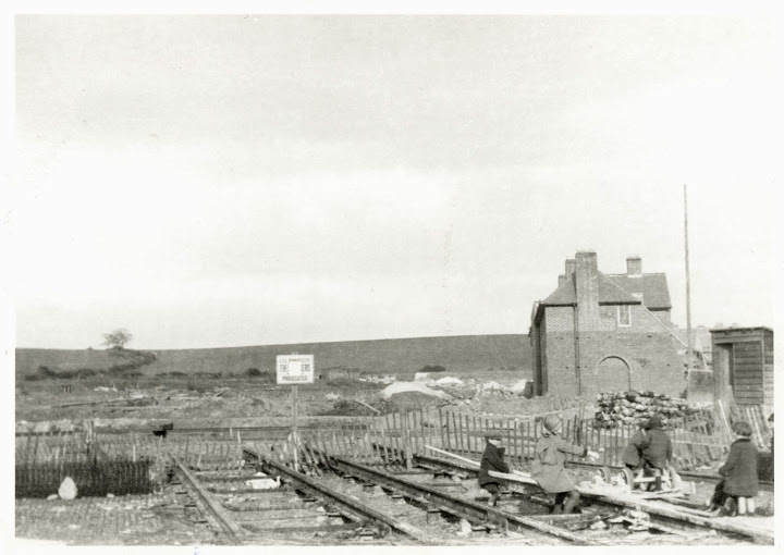
Downham Estate, Under Construction In 1926
Downham is a district of south-east London, England, within the London Borough of Lewisham. It borders the London Borough of Bromley, and is located north of Bromley and south of Catford. Downham was named in honour of Hayes Fisher, 1st Baron Downham, Lord Downham, who was chairman of the London County Council between 1919 and 1920. The Prime Meridian passes just to the west of Downham. History Origins of Downham estate Before 1920, the area had no houses, apart from a shooting range close to Rangefield Road and areas of farmland in the period around 1890. Some belonged to Holloway Farm and others to Shroffolds Farm. Following the First World War, local boroughs like Metropolitan Borough of Deptford, Deptford and Metropolitan Borough of Bermondsey, Bermondsey as well as the London County Council [LCC] felt it was essential to reduce overcrowding by erecting more residential property and exceed that which was provided by private landlords. The final spur for the LCC to comme ... [...More Info...] [...Related Items...] OR: [Wikipedia] [Google] [Baidu] |
Downham
Downham is a district of south-east London, England, within the London Borough of Lewisham. It borders the London Borough of Bromley, and is located north of Bromley and south of Catford. Downham was named in honour of Lord Downham, who was chairman of the London County Council between 1919 and 1920. The Prime Meridian passes just to the west of Downham. History Origins of Downham estate Before 1920, the area had no houses, apart from a shooting range close to Rangefield Road and areas of farmland in the period around 1890. Some belonged to Holloway Farm and others to Shroffolds Farm. Following the First World War, local boroughs like Deptford and Bermondsey as well as the London County Council CCfelt it was essential to reduce overcrowding by erecting more residential property and exceed that which was provided by private landlords. The final spur for the LCC to commence works in the area was the new law of 1923 that provided government funding to enable residential deve ... [...More Info...] [...Related Items...] OR: [Wikipedia] [Google] [Baidu] |
Bromley
Bromley is a large town in Greater London, England, within the London Borough of Bromley. It is south-east of Charing Cross, and had an estimated population of 87,889 as of 2011. Originally part of Kent, Bromley became a market town, chartered in 1158. Its location on a coaching route and the opening of a railway station in 1858 were key to its development and the shift from an agrarian village to an urban town. As part of the suburban growth of London in the 20th century, Bromley significantly increased in population and was Municipal Borough of Bromley, incorporated as a municipal borough in 1903 and became part of the London Borough of Bromley in 1965. Bromley today forms a major retail and commercial centre. It is identified in the London Plan as one of the 13 metropolitan centres of Greater London. History Bromley is first recorded in an Anglo-Saxon charter of 862 as ''Bromleag'' and means 'woodland clearing where Cytisus scoparius, broom grows'. It shares this Old ... [...More Info...] [...Related Items...] OR: [Wikipedia] [Google] [Baidu] |
Metropolitan Borough Of Lewisham
The Metropolitan Borough of Lewisham was a Metropolitan borough in the County of London between 1900 and 1965, when it became part of the London Borough of Lewisham along with the Metropolitan Borough of Deptford. History The borough was formed by the London Government Act 1899 from the civil parishes of Lee from the Lee District and Lewisham from the Lewisham District. The borough also took in a small area formerly administered by Camberwell Vestry on the western slopes of Forest Hill. While there had been minor industry along the River Ravensbourne for centuries and the extension of the railways had seen suburban development, there were still large areas of farmland at the time of the borough's formation. The next London property boom in the 1930s saw much of that farmland built upon with both private estates, and the final gaps on the roads to Kent were filled in later on with London County Council built social housing, particularly in Downham and Bellingham. Geography T ... [...More Info...] [...Related Items...] OR: [Wikipedia] [Google] [Baidu] |
Districts Of The London Borough Of Lewisham
A district is a type of administrative division that, in some countries, is managed by the local government. Across the world, areas known as "districts" vary greatly in size, spanning regions or county, counties, several municipality, municipalities, subdivisions of municipalities, school district, or political district. By country/region Afghanistan In Afghanistan, a district (Persian language, Persian ps, ولسوالۍ ) is a subdivision of a province. There are almost 400 districts in the country. Australia Electoral districts are used in state elections. Districts were also used in several states as cadastral units for land titles. Some were used as squatting districts. Cadastral divisions of New South Wales, New South Wales had several different types of districts used in the 21st century. Austria In Austria, the word is used with different meanings in three different contexts: * Some of the tasks of the administrative branch of the national and regional governme ... [...More Info...] [...Related Items...] OR: [Wikipedia] [Google] [Baidu] |
Buildings And Structures In The London Borough Of Bromley
A building, or edifice, is an enclosed structure with a roof and walls standing more or less permanently in one place, such as a house or factory (although there's also portable buildings). Buildings come in a variety of sizes, shapes, and functions, and have been adapted throughout history for a wide number of factors, from building materials available, to weather conditions, land prices, ground conditions, specific uses, prestige, and aesthetic reasons. To better understand the term ''building'' compare the list of nonbuilding structures. Buildings serve several societal needs – primarily as shelter from weather, security, living space, privacy, to store belongings, and to comfortably live and work. A building as a shelter represents a physical division of the human habitat (a place of comfort and safety) and the ''outside'' (a place that at times may be harsh and harmful). Ever since the first cave paintings, buildings have also become objects or canvasses of much artis ... [...More Info...] [...Related Items...] OR: [Wikipedia] [Google] [Baidu] |
Buildings And Structures In The London Borough Of Lewisham
A building, or edifice, is an enclosed structure with a roof and walls standing more or less permanently in one place, such as a house or factory (although there's also portable buildings). Buildings come in a variety of sizes, shapes, and functions, and have been adapted throughout history for a wide number of factors, from building materials available, to weather conditions, land prices, ground conditions, specific uses, prestige, and aesthetic reasons. To better understand the term ''building'' compare the list of nonbuilding structures. Buildings serve several societal needs – primarily as shelter from weather, security, living space, privacy, to store belongings, and to comfortably live and work. A building as a shelter represents a physical division of the human habitat (a place of comfort and safety) and the ''outside'' (a place that at times may be harsh and harmful). Ever since the first cave paintings, buildings have also become objects or canvasses of much artistic ... [...More Info...] [...Related Items...] OR: [Wikipedia] [Google] [Baidu] |
Housing Estates In London
Housing, or more generally, living spaces, refers to the construction and assigned usage of houses or buildings individually or collectively, for the purpose of shelter. Housing ensures that members of society have a place to live, whether it is a home or some other kind of dwelling, lodging or shelter. Many governments have one or more housing authorities, sometimes also called a housing ministry or housing department. Housing in many different areas consists of public, social and private housing. In the United States, it was not until the 19th and 20th century that there was a lot more government involvement in housing. It was mainly aimed at helping those who were poor in the community. Public housing provides help and assistance to those who are poor and mainly low-income earners. A study report shows that there are many individuals living in public housing. There are over 1.2 million families or households. These types of housing were built mainly to provide people, main ... [...More Info...] [...Related Items...] OR: [Wikipedia] [Google] [Baidu] |
Rotherhithe
Rotherhithe () is a district of south-east London, England, and part of the London Borough of Southwark. It is on a peninsula on the south bank of the Thames, facing Wapping, Shadwell and Limehouse on the north bank, as well as the Isle of Dogs to the east of the Thames and is a part of the London Docklands, Docklands area. It borders Bermondsey to the west and Deptford to the south east. Rotherhithe has a long history as a port, with Elizabethan era, Elizabethan shipyards and working docks until the 1970s. In the 1980s, the area along the river was redeveloped as housing through a mix of warehouse conversions and new-build developments. Following the arrival of the Jubilee line in 1999 (giving quick connections to the West End of London, West End and to Canary Wharf) and the London Overground in 2010 (providing a quick route to the City of London), the rest of Rotherhithe is now a gentrification, gentrifying residential and commuter area, with urban regeneration progressing arou ... [...More Info...] [...Related Items...] OR: [Wikipedia] [Google] [Baidu] |
List Of Chairmen Of The London County Council
This is a list of persons who held the offices of chairman, vice chairman and deputy chairman of the London County Council. All three offices existed from 1889 to 1965. Background The chairmanship and vice chairmanship were statutory offices created by the Local Government Act 1888. Both of these positions were generally filled by members of the majority party. The chairman chaired meetings of the council, and was the county's civic leader, filling a similar role to the mayor of a borough or city. The vice chairman performed these functions in his or her absence. As part of the celebrations of the silver jubilee of George V in 1935 it was announced that the chairman would in future be entitled to use the style "right honourable", an honour already enjoyed by the Lord Mayor of London. The council's standing orders also provided for the post of deputy chairman. This was initially a salaried position created to supervise the administration of the local authority. In 1894 the Roya ... [...More Info...] [...Related Items...] OR: [Wikipedia] [Google] [Baidu] |
William Hayes Fisher, 1st Baron Downham
William Hayes Fisher, 1st Baron Downham, PC, KStJ (1853 – 2 July 1920) was a British Conservative Party politician. He held office as President of the Local Government Board and Minister of Information in David Lloyd George's First World War coalition government. Background and education Born at Downham, (known now as 'Little Downham') in the Isle of Ely, Fisher was the son of Reverend Frederick Fisher, rector of that parish, and Mary, daughter of William Hayes. He was educated at Haileybury and University College, Oxford, and was called to the Bar, Inner Temple, in 1879. Political career Fisher was elected to the House of Commons for Fulham in 1885, a seat he held until 1906. He was private secretary Sir Michael Hicks Beach between 1886 and 1887 and to Arthur Balfour between 1887 and 1892 (who both served as Chief Secretary for Ireland at the time). In 1896 he was appointed a Junior Lord of the Treasury (government whip) in the Conservative administration of Lord Salis ... [...More Info...] [...Related Items...] OR: [Wikipedia] [Google] [Baidu] |
Grove Park Railway Station
Grove Park is a railway station in southeast London, England. It is located on Baring Road (the A2212) within Travelcard Zone 4, and serves the areas of Grove Park and Downham in the London Borough of Lewisham. It is down the line from . It serves as an interchange between local South Eastern Main Line services & the Bromley North Line shuttle. Prior to 1952 there was also a connection to trams. The station was opened in 1871. Platforms Currently there are five platforms. Platform 1 serves Bromley North branch line, which is detached from the rest of the station, while platforms 2 to 5 are on the South Eastern Main Line which runs from Charing Cross to Hastings. The adjacent stations are Elmstead Woods to the south, Hither Green to the north, and Sundridge Park on the Bromley North branch line. There are regular services to London Charing Cross and London Cannon Street. Services All services at Grove Park are operated by Southeastern using , , and EMUs. The typi ... [...More Info...] [...Related Items...] OR: [Wikipedia] [Google] [Baidu] |


.jpg)


