|
Dunragit
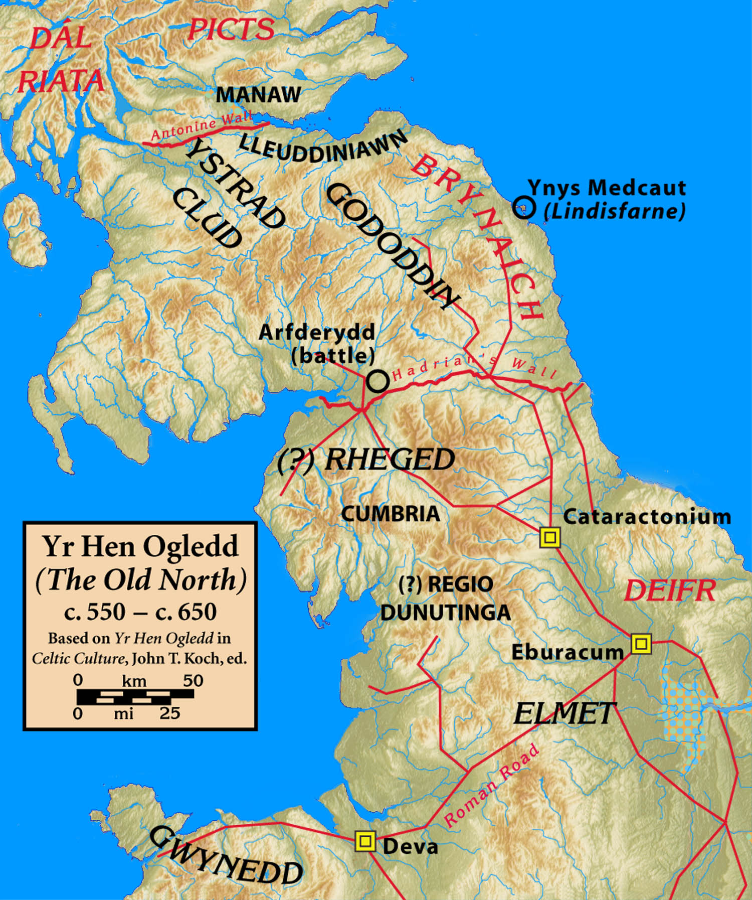
Dunragit ( gd, Dùn Reicheit) is a village on the A75, between Stranraer and Glenluce in Dumfries and Galloway, south-west Scotland. Dunragit is within the parish of Old Luce, in the traditional county of Wigtownshire. The modern village grew up around the west gate of Dunragit House, an 18th-century country house, though there is evidence of Neolithic settlement in the area. Toponymy The place-name Dunragit is said to derive from ''Din Rheged'' meaning "Fort of Rheged", referring to the Brythonic kingdom of Rheged which existed in northern Britain between the 5th and 8th centuries. RE Dunragit monument complex Between 1999 and 2002, archeological excavations have explored the Dunragit area, and a complex of Neolithic monuments has been uncovered. Nothing can now be seen above ground, but aerial photography and excavation has revealed an early Neolithic cursus monument, and the remains of three later Neolithic concentric timber circles, dating to around 2500 BC; the outer circl ... [...More Info...] [...Related Items...] OR: [Wikipedia] [Google] [Baidu] |
Droughdool Mote
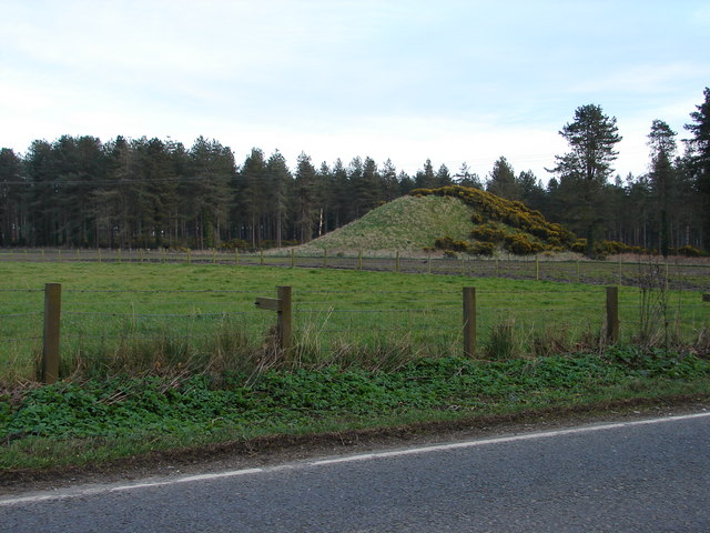
Droughdool Mote (also spelled Droughduil) () is a Neolithic round mound in the parish of Old Luce, Wigtownshire, Dumfries and Galloway. The mound is oval in plan, measuring 60m by 50m at its base and rises to 10m in height. It is located 400m south of the late neolithic palisaded enclosure at Dunragit. It has been suggested that the mound may have been used as a viewing platform for activities at Dunragit complex of monuments. The most well known parallel the site has is Silbury Hill in Wiltshire, but is closer in size to the less well known sites at Conquer Barrow, Willy Howe and Wold Newton. The mound was originally built with stepped sides on top of a sand dune. Excavation between 1999-2002 revealed a round cairn at the top of the mound, similar to the nearby Mid Gleniron A. The mound was assumed to be a medieval mote for a castle, but is different in structure and location to the motes in the surrounding area. In 2002, excavation and optically stimulated luminescence dating s ... [...More Info...] [...Related Items...] OR: [Wikipedia] [Google] [Baidu] |
Old Luce
Old Luce is a civil parish in Dumfries and Galloway, Scotland. It lies in the Machars peninsula, in the traditional county of Wigtownshire. The parish is around long and broad, and contains . It was anciently named Glenluce which was divided in 1646 into two parts, the northern one named New Luce, and the southern one named Old Luce. In 1661 the two parishes of Old and New Luce were reunited for a time, and when the 1684 Wigtownshire Parish List was recorded, it listed both Old Luce and New Luce under “Glenluce Parish”. In 1688, after the Glorious Revolution, the separation of Old Luce and New Luce became permanent. Old Luce has a Community Council. Villages and places in Old Luce The town of Glenluce and Glenluce Church are in Old Luce Parish, as is Glenluce Abbey. In 1846 in the Topographical Dictionary of Scotland, Samuel Lewis wrote that the village of Glenluce was situated upon the road leading from Newton Stewart to Stranraer. "The church, erected in 1814, ... [...More Info...] [...Related Items...] OR: [Wikipedia] [Google] [Baidu] |
A75 Road
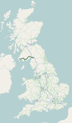
The A75 is a primary trunk road in Scotland, linking Stranraer and its ferry ports at Cairnryan with the A74(M) at Gretna, close to the border with England and the M6 motorway. Route Heading west along the south coast of Scotland from its junction with the A74(M) motorway at Gretna it continues past Eastriggs, Annan, Dumfries, Castle Douglas, Gatehouse of Fleet, Newton Stewart, Kirkcowan and Glenluce before ending at Stranraer. The majority of the road is of single-carriageway standard, although a few short dual carriageway sections exist, including a one-mile section past Gretna, a section past Collin (just east of Dumfries,) a two-mile section just west of Dumfries and a 1-mile section at Barlae (Between Glenluce and Newton Stewart). The road is widely felt to be unfit for the current large volumes of freight using it, but successive Westminster and laterly Scottish Governments have repeatedly shelved previously planned substantive upgrades, and delayed much needed ... [...More Info...] [...Related Items...] OR: [Wikipedia] [Google] [Baidu] |
Wigtownshire
Wigtownshire or the County of Wigtown (, ) is one of the historic counties of Scotland, covering an area in the south-west of the country. Until 1975, Wigtownshire was an administrative county used for local government. Since 1975 the area has formed part of Dumfries and Galloway for local government purposes. Wigtownshire continues to be used as a territory for land registration, being a registration county. The historic county is all within the slightly larger Wigtown Area, which is one of the lieutenancy areas of Scotland and was used in local government as the Wigtown District from 1975 to 1996. Wigtownshire forms the western part of the medieval lordship of Galloway, which retained a degree of autonomy until it was fully absorbed by Scotland in the 13th century. In 1369, the part of Galloway east of the River Cree was placed under the control of a steward and so became known as the Stewartry of Kirkcudbright. The rest of Galloway remained under the authority of a sherif ... [...More Info...] [...Related Items...] OR: [Wikipedia] [Google] [Baidu] |
Rheged
Rheged () was one of the kingdoms of the ''Hen Ogledd'' ("Old North"), the Brittonic-speaking region of what is now Northern England and southern Scotland, during the post-Roman era and Early Middle Ages. It is recorded in several poetic and bardic sources, although its borders are not described in any of them. A recent archaeological discovery suggests that its stronghold was located in what is now Galloway in Scotland rather than, as was previously speculated, being in Cumbria. Rheged possibly extended into Lancashire and other parts of northern England. In some sources, Rheged is intimately associated with the king Urien Rheged and his family. Its inhabitants spoke Cumbric, a Brittonic dialect closely related to Old Welsh. Etymology The origin of the name ''Rheged'' has been described as "problematic". One Brittonic-language solution is that the name may be a compound of ''rö-'', a prefix meaning "great", and ''cę:d'' meaning "wood, forest" (c.f. Welsh ''coed'') alt ... [...More Info...] [...Related Items...] OR: [Wikipedia] [Google] [Baidu] |
Stranraer
Stranraer ( , in Scotland also ; gd, An t-Sròn Reamhar ), also known as The Toon, is a town in Dumfries and Galloway, Scotland. It is located in the historical parish of Inch in the historic county of Wigtownshire. It lies on the shores of Loch Ryan, on the northern side of the isthmus joining the Rhins of Galloway to the mainland. Stranraer is Dumfries and Galloway's second-largest town, with a population including the immediate surrounding area of nearly 13,000 inhabitants. Stranraer is an administrative centre for the West Galloway Wigtownshire area of Dumfries and Galloway. It was formerly a ferry port, connecting Scotland with Belfast and Larne in Northern Ireland; the last service was transferred to nearby Cairnryan in November 2011. It lies by road southwest of Glasgow, miles southwest of Ayr and to the west of Dumfries. The name comes from Scottish Gaelic '' An t-Sròn Reamhar'' meaning "the broad headland" or "the fat nose". History The Battle of Loch Ry ... [...More Info...] [...Related Items...] OR: [Wikipedia] [Google] [Baidu] |
Glenluce
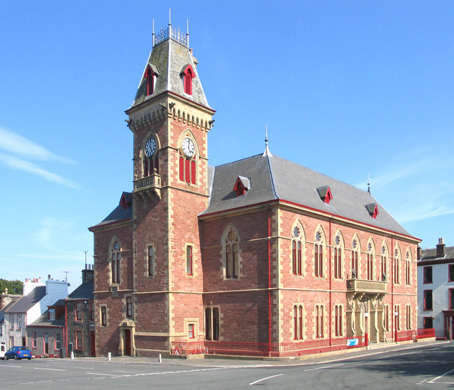
Glenluce ( gd, Clachan Ghlinn Lus) is a small village in the parish of Old Luce in Wigtownshire, Scotland. It contains a village shop,a caravan park and a town hall, as well as the parish church. Location Glenluce on the A75 road between Stranraer () and Newton Stewart (). It's south of Glasgow, west of Dumfries and south west of Edinburgh. The Church The Parish Church of Glenluce, with the two chapels, was vested by the king in 1587. In 1646 the parish of Glenluce was split in two to form Old Luce Parish Church and New Luce Parish Church. However, in 2016 the parishes churches were reunited to form Luce Valley Church, which covers Auchenmalg, Dunragit, Glenluce and New Luce, as well as the surrounding area. They meet at 11am every Sunday in the church in Glenluce and the current minister is Rev Stephen Ogston. Castle of Park The Castle of Park is an L-plan tower house near the village. It was built in 1596 by Thomas Hay, upon the lands given to him by his father, who ... [...More Info...] [...Related Items...] OR: [Wikipedia] [Google] [Baidu] |
Dumfries And Galloway
Dumfries and Galloway ( sco, Dumfries an Gallowa; gd, Dùn Phrìs is Gall-Ghaidhealaibh) is one of 32 unitary council areas of Scotland and is located in the western Southern Uplands. It covers the historic counties of Dumfriesshire, Kirkcudbrightshire, and Wigtownshire, the latter two of which are collectively known as Galloway. The administrative centre and largest settlement is the town of Dumfries. The second largest town is Stranraer, on the North Channel coast, some to the west of Dumfries. Following the 1975 reorganisation of local government in Scotland, the three counties were joined to form a single region of Dumfries and Galloway, with four districts within it. The districts were abolished in 1996, since when Dumfries and Galloway has been a unitary local authority. For lieutenancy purposes, the area is divided into three lieutenancy areas called Dumfries, Wigtown and the Stewartry of Kirkcudbright, broadly corresponding to the three historic counties. ... [...More Info...] [...Related Items...] OR: [Wikipedia] [Google] [Baidu] |
Nestlé
Nestlé S.A. (; ; ) is a Swiss multinational food and drink processing conglomerate corporation headquartered in Vevey, Vaud, Switzerland. It is the largest publicly held food company in the world, measured by revenue and other metrics, since 2014."Nestlé's Brabeck: We have a "huge advantage" over big pharma in creating medical foods" , ''CNN Money'', 1 April 2011 It ranked No. 64 on the ''Fortune'' Global 500 in 2017 and No. 33 in the 2016 edition of the '' Forbes'' Global 2000 list of largest public companies. Nestlé's p ... [...More Info...] [...Related Items...] OR: [Wikipedia] [Google] [Baidu] |
Tresco, Isles Of Scilly
Tresco ( kw, Enys Skaw, meaning "island of elder-trees") is the second-biggest island of the Isles of Scilly in Cornwall, England. It is in size, measuring about by . History In early times one group of islands was in the possession of a confederacy of hermits. King Henry I gave it to Tavistock Abbey which established a priory on Tresco; it was abolished during the Dissolution of the Monasteries. The priory was given the care of souls in the secular islands by the lord of the fief. In 1233, a prior here, known as Alan of Cornwall, was made Abbot of Tavistock. The original name for the island (including Bryher) was the kw, Ryn Tewyn, meaning "promontory of sand-dunes". In 1193, when the island was granted to the Abbot of Tavistock by Pope Celestine III, the island was known as ''St. Nicholas's island'', and by 1305 it is called ''Trescau'' (farm of elder-trees). By 1540 this has changed to ''Iniscaw'' (island of elder-trees). The island was named as ''Trescaw'' in an 18 ... [...More Info...] [...Related Items...] OR: [Wikipedia] [Google] [Baidu] |
Isles Of Scilly
The Isles of Scilly (; kw, Syllan, ', or ) is an archipelago off the southwestern tip of Cornwall, England. One of the islands, St Agnes, is the most southerly point in Britain, being over further south than the most southerly point of the British mainland at Lizard Point. The total population of the islands at the 2011 United Kingdom census was 2,203. Scilly forms part of the ceremonial county of Cornwall, and some services are combined with those of Cornwall. However, since 1890, the islands have had a separate local authority. Since the passing of the Isles of Scilly Order 1930, this authority has had the status of a county council and today is known as the Council of the Isles of Scilly. The adjective "Scillonian" is sometimes used for people or things related to the archipelago. The Duchy of Cornwall owns most of the freehold land on the islands. Tourism is a major part of the local economy, along with agriculture—particularly the production of cut flower ... [...More Info...] [...Related Items...] OR: [Wikipedia] [Google] [Baidu] |
Bronze Age
The Bronze Age is a historic period, lasting approximately from 3300 BC to 1200 BC, characterized by the use of bronze, the presence of writing in some areas, and other early features of urban civilization. The Bronze Age is the second principal period of the three-age system proposed in 1836 by Christian Jürgensen Thomsen for classifying and studying ancient societies and history. An ancient civilization is deemed to be part of the Bronze Age because it either produced bronze by smelting its own copper and alloying it with tin, arsenic, or other metals, or traded other items for bronze from production areas elsewhere. Bronze is harder and more durable than the other metals available at the time, allowing Bronze Age civilizations to gain a technological advantage. While terrestrial iron is naturally abundant, the higher temperature required for smelting, , in addition to the greater difficulty of working with the metal, placed it out of reach of common use until th ... [...More Info...] [...Related Items...] OR: [Wikipedia] [Google] [Baidu] |
.jpg)
