|
Dettighofen, Baden-Württemberg
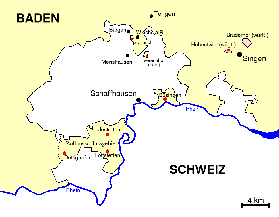
Dettighofen is a village and municipality in the district of Waldshut in Baden-Württemberg in Germany. History From 1840 until 1935, the original territory of Dettighofen, along with Jestetten, Lottstetten and Altenburg, was part of the region which formed a customs exclusion zone and was not part of the German customs area. Inhabitants were able to offer their produce to the rest of Germany as well as to Switzerland. This situation brought about a higher standard of living and prosperity compared to the rest of Germany. In 1927 the hamlet Häuserhof which had been part of neighbouring Weisweil, became part of Dettighofen as did the hamlet Eichberg which until that year had been part of Bühl. On 1 April 1936 the hamlet Albführen became part of the municipality of Dettighofen. On 1 January 1974 the municipalities of Berwangen and Baltersweil merged to become part of Dettighofen. Geography Dettighofen is located close to the Swiss border. Switzerland lies both to the ... [...More Info...] [...Related Items...] OR: [Wikipedia] [Google] [Baidu] |
Waldshut (district)
Waldshut () is a ''Landkreis'' (district) in the south of Baden-Württemberg, Germany. Neighbouring districts are (clockwise from the west) Lörrach, Breisgau-Hochschwarzwald and Schwarzwald-Baar; followed in the south by the Swiss cantons of Schaffhausen, Zürich and Aargau. History The district dates to the ''Oberamt Waldshut'', which was created when the area became part of the state of Baden in the beginning of the 19th century. After some changes it was converted to a district in 1938. In 1973 the districts Säckingen and Hochschwarzwald were dissolved and were partially added to the district Waldshut, which then grew to its current size. Geography The district covers the southern part of the Black Forest. The river Rhine The Rhine ( ) is one of the List of rivers of Europe, major rivers in Europe. The river begins in the Swiss canton of Graubünden in the southeastern Swiss Alps. It forms part of the Swiss-Liechtenstein border, then part of the Austria–Swit ... fo ... [...More Info...] [...Related Items...] OR: [Wikipedia] [Google] [Baidu] |
Baden-Württemberg
Baden-Württemberg ( ; ), commonly shortened to BW or BaWü, is a states of Germany, German state () in Southwest Germany, east of the Rhine, which forms the southern part of Germany's western border with France. With more than 11.07 million inhabitants across a total area of nearly , it is the third-largest German state by both List of German states by area, area (behind Bavaria and Lower Saxony) and List of German states by population, population (behind North Rhine-Westphalia and Bavaria). The List of cities in Baden-Württemberg by population, largest city in Baden-Württemberg is the state capital of Stuttgart, followed by Mannheim and Karlsruhe. Other major cities are Freiburg im Breisgau, Heidelberg, Heilbronn, Konstanz, Pforzheim, Reutlingen, Tübingen, and Ulm. Modern Baden-Württemberg includes the historical territories of Baden, Prussian Province of Hohenzollern, Hohenzollern, and Württemberg. Baden-Württemberg became a state of West Germany in April 1952 through ... [...More Info...] [...Related Items...] OR: [Wikipedia] [Google] [Baidu] |
Germany
Germany, officially the Federal Republic of Germany, is a country in Central Europe. It lies between the Baltic Sea and the North Sea to the north and the Alps to the south. Its sixteen States of Germany, constituent states have a total population of over 84 million in an area of , making it the most populous member state of the European Union. It borders Denmark to the north, Poland and the Czech Republic to the east, Austria and Switzerland to the south, and France, Luxembourg, Belgium, and the Netherlands to the west. The Capital of Germany, nation's capital and List of cities in Germany by population, most populous city is Berlin and its main financial centre is Frankfurt; the largest urban area is the Ruhr. Settlement in the territory of modern Germany began in the Lower Paleolithic, with various tribes inhabiting it from the Neolithic onward, chiefly the Celts. Various Germanic peoples, Germanic tribes have inhabited the northern parts of modern Germany since classical ... [...More Info...] [...Related Items...] OR: [Wikipedia] [Google] [Baidu] |
Jestetten
Jestetten is a municipality in the district of Waldshut (district), Waldshut in Baden-Württemberg in Germany. History In 1806 Jestetten became part of Baden. From 1840 until 1935, the territory of Jestetten together with Altenburg, Lottstetten and what was then Dettighofen, Baden-Württemberg, Dettighofen, was part of the region which formed a customs exclusion zone and was not part of the German customs area. Inhabitants were able to offer their produce to the rest of Germany as well as to Switzerland. This situation brought about a higher standard of living and prosperity compared to the rest of Germany. Geography The border crossing into Switzerland is located to the east of town along Schaffhauserstraße leading to Neuhausen am Rheinfall. Another border crossing in the municipality is located south west of town along Osterfingerstraße, towards the villager of Osterfingen in Wilchingen municipality, Schaffhausen (canton), Schaffhausen canton. Transport Jestetten railway ... [...More Info...] [...Related Items...] OR: [Wikipedia] [Google] [Baidu] |
Lottstetten
Lottstetten is a municipality in the district of Waldshut (district), Waldshut in Baden-Württemberg in Germany. History In 1806 Lottstetten became part of Baden. From 1840 until 1935, the territory of Lottstetten together with Altenburg, Jestetten and what was then Dettighofen, Baden-Württemberg, Dettighofen, was part of the region which formed a customs exclusion zone and was not part of the German customs area. Inhabitants were able to offer their produce to the rest of Germany as well as to Switzerland. This situation brought about a higher standard of living and prosperity compared to the rest of Germany. Geography Lottstetten is surrounded on three sides by the international and customs Germany–Switzerland border, border with Switzerland. To the west, south and east of the village lies the Rhine and Swiss territory. Road border crossings into Switzerland are located near Lottstetten with Rafz in Zurich (canton), canton Zurich, with Solgen part of Rafz and the Nack to Is ... [...More Info...] [...Related Items...] OR: [Wikipedia] [Google] [Baidu] |
Dettighofen In WT , Germany
{{geodis ...
Dettighofen may refer to: * Dettighofen, Switzerland *Dettighofen, Baden-Württemberg Dettighofen is a village and municipality in the district of Waldshut in Baden-Württemberg in Germany. History From 1840 until 1935, the original territory of Dettighofen, along with Jestetten, Lottstetten and Altenburg, was part of the reg ... [...More Info...] [...Related Items...] OR: [Wikipedia] [Google] [Baidu] |
Canton Of Schaffhausen
The canton of Schaffhausen, also canton of Schaffhouse (; ; ; ), is the northernmost Cantons of Switzerland, canton of Switzerland. The principal city and capital of the canton is Schaffhausen. The canton's territory is divided into three non-contiguous segments, where German territory reaches the Rhine. The large central part, which includes the capital, in turn separates the German exclave of Büsingen am Hochrhein from the rest of Germany. History Schaffhausen was a city-state in the Middle Ages; it is documented that it struck its own coins starting in 1045. It was then documented as ''Villa Scafhusun''. Around 1049, Count Eberhard von Nellenburg founded a Benedictine monastery which led to the development of a community. This community achieved independence in 1190. In 1330, the town lost not only all its lands but also its independence to the Habsburgs. In 1415, the Habsburg Duke Frederick IV, Duke of Austria, Frederick IV of Austria sided with the Antipope John XXIII at ... [...More Info...] [...Related Items...] OR: [Wikipedia] [Google] [Baidu] |
Canton Zurich
The canton of Zurich is an administrative unit ( canton) of Switzerland, situated in the northeastern part of the country. With a population of (as of ), it is the most populous canton of Switzerland. Zurich is the ''de facto'' capital of the canton, but is not specifically mentioned in the constitution. The official language is German. The local Swiss German dialect, called ''Züritüütsch'', is commonly spoken. The canton has the highest Human Development Index score (0.994) out of 1,790 subnational regions as of 2022. It is also a global financial center and has the fourth-highest GRP in Switzerland behind Basel-Stadt, Zug and Geneva by GDP per capita. History Early history The prehistoric pile dwellings around Lake Zurich, which are located around Lake Zurich in the cantons of Schwyz, St. Gallen and Zurich, make up a considerable portion of the 56 sites in Switzerland that are included in the UNESCO World Heritage Prehistoric pile dwellings around the Alps. Nine o ... [...More Info...] [...Related Items...] OR: [Wikipedia] [Google] [Baidu] |


