|
Mauritania–Senegal Border
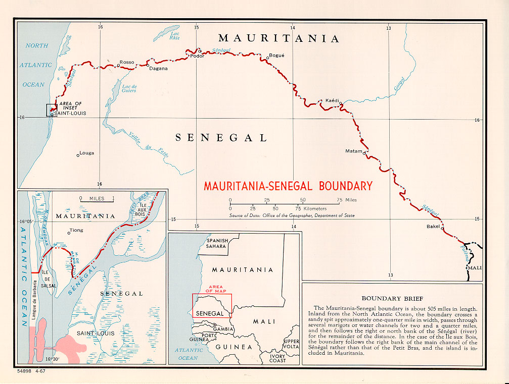
The Mauritania–Senegal border is in length and runs from the Atlantic Ocean in the west along the Senegal River to the tripoint with Mali in the east. Description The border starts in the west at the Atlantic coast and then goes east, crossing the Langue de Barbarie spit, and then veers north, utilizing the ''Marigot de Mambatio'', before reaching the Senegal river. The border then follows this river eastwards in a broad arc, terminating at the Mali tripoint at the Senegal/ Falémé confluence. History France had begun settling on the coasts of modern Mauritania and Senegal in the 17th-18th centuries, gradually extended their rule further inland as far as modern Mali during the 1850s-80s. As a result of the ‘Scramble for Africa’ in the 1880s, France gained control the upper valley of the Niger River (roughly equivalent to the areas of modern Mali and Niger). France occupied this area in 1900, followed by Mauritania in 1903–04. Mali (then referred to as French Sudan) ... [...More Info...] [...Related Items...] OR: [Wikipedia] [Google] [Baidu] |
Mauritania Senegal Border
Mauritania, officially the Islamic Republic of Mauritania, is a sovereign country in Northwest Africa. It is bordered by the Atlantic Ocean to the west, Western Sahara to the north and northwest, Algeria to the northeast, Mali to the east and southeast, and Senegal to the southwest. By land area Mauritania is the 11th-largest country in Africa and 28th-largest in the world; 90% of its territory is in the Sahara. Most of its population of some 4.3 million lives in the temperate south of the country; roughly a third of the population is concentrated in the capital and largest city, Nouakchott, on the Atlantic coast. The country's name derives from Mauretania, the Latin name for a region in the ancient Maghreb. It extended from central present-day Algeria to the Atlantic. Berbers occupied what is now Mauritania by the beginning of the third century AD. Groups of Arab tribes migrated to this area in the late seventh century, bringing with them Islam, Arab culture, and t ... [...More Info...] [...Related Items...] OR: [Wikipedia] [Google] [Baidu] |
French Community
The French Community () was the constitutional organization set up in October 1958 between France and its remaining African colonies, then in the process of decolonization. It replaced the French Union, which had reorganized the colonial empire in 1946. While the Community remained formally in existence until 1995, when the French Parliament officially abolished it, it had effectively ceased to exist and function by the end of 1960, by which time all the African members had declared their independence and left it. The Community had a short lifespan because, while the African members did not refuse it, they refrained from real involvement. Under the appearance of equality, the constitution of the Community restricted the sovereignty of the twelve African states, and reaffirmed the preeminence of France, by placing in the ''domaine commun'' (exercised in common) critical functions such as foreign affairs, defence, the currency, economic policies and control of raw materials. ... [...More Info...] [...Related Items...] OR: [Wikipedia] [Google] [Baidu] |
Podor
Podor ( Wolof: Podoor) is the northernmost town in Senegal, lying on Morfil Island between the Sénégal River and Doué River on the border with Mauritania. It was the location of the ancient state Takrur. It is home to a ruined French colonial fort, built in 1854 as a centre for gold trading, and is the birthplace of fashion designer Oumou Sy, as well as musicians Baaba Maal and Mansour Seck. At the 2013 census the population of the town was 11,608. According to the 2023 census, it had grown to 12,512. It is 99% Muslim. Climate Podor has a Sahel The Sahel region (; ), or Sahelian acacia savanna, is a Biogeography, biogeographical region in Africa. It is the Ecotone, transition zone between the more humid Sudanian savannas to its south and the drier Sahara to the north. The Sahel has a ...ian climate, with extremely hot summers with some rain and very warm, almost rainless winters. References Populated places in Saint-Louis region Communes of Senegal [...More Info...] [...Related Items...] OR: [Wikipedia] [Google] [Baidu] |
Dagana, Senegal
Dagana is a town and urban commune situated in the Saint-Louis Region of Senegal and it is the capital of the Dagana Department, Senegal, Dagana Department. Dagana Mauritania–Senegal border, borders Mauritania across the Senegal river. The different ethnic groups in Dagana include Wolof people, Wolof, Fula people, Fula (; ''or'' Peulh), and Moors, Moor. History The village was founded in the 14th century. In 1820 the French installed a fort in Dagana, which was expanded over time. On June 18th 1833, Njembot Mbodj, lingeer of Waalo, married the Trarza Moorish leader Mohamed El Habib in Dagana. In March 1908 the French fort was unsuccessfully attacked by the marabout Aly Yoro Dia, who was killed in the attempt. In popular culture In List of The Grand Tour episodes#Series 5 (2022–present), Season 5, Episode 3 of The Grand Tour, presenters Jeremy Clarkson, Richard Hammond and James May use discarded plastic bottles to float cars across the Senegal River at Dagana, as part of ... [...More Info...] [...Related Items...] OR: [Wikipedia] [Google] [Baidu] |
Saint-Louis, Senegal
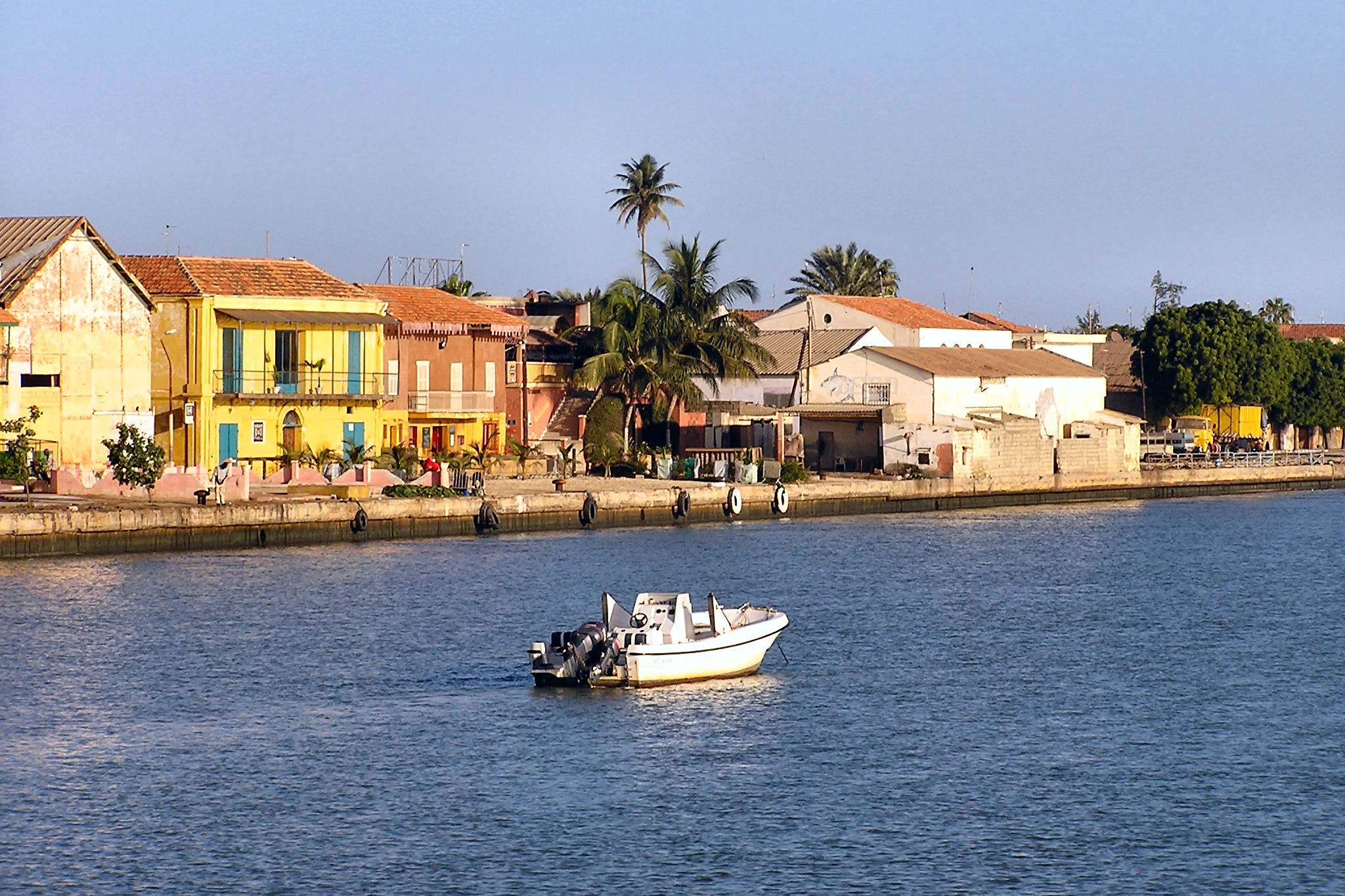
Saint-Louis () or Saint Louis (), is the capital of Senegal's Saint-Louis Region. Located in the northwest of Senegal, near the mouth of the Senegal River, and north of Senegal's capital city Dakar. It had a population of 254,171 in 2023. Saint-Louis was the capital of the French colony of Senegal from 1673 until 1902 and French West Africa from 1895 until 1902, when the capital was moved to Dakar. From 1920 to 1957, it also served as the capital of the neighboring colony of Mauritania. The town was an important economic center during the period of French West Africa, but it is less important now. Nonetheless, it still has important industries, including tourism, a commercial center, sugar production, and fishing. The tourism industry is in part due to the city being listed as a UNESCO World Heritage Site in 2000. However, the city is also Climate change vulnerability, vulnerable to climate change—where sea level rise is expected to threaten the city center and potentially damag ... [...More Info...] [...Related Items...] OR: [Wikipedia] [Google] [Baidu] |
Sagne, Mauritania
Sagne is a village and rural commune in Mauritania, located on the border with Senegal Senegal, officially the Republic of Senegal, is the westernmost country in West Africa, situated on the Atlantic Ocean coastline. It borders Mauritania to Mauritania–Senegal border, the north, Mali to Mali–Senegal border, the east, Guinea t .... Communes of Mauritania {{Mauritania-geo-stub ... [...More Info...] [...Related Items...] OR: [Wikipedia] [Google] [Baidu] |
Kaédi
Kaédi () is the largest city and administrative center of the Gorgol Region of Southern Mauritania, located on the Mauritania–Senegal border, border with Senegal. It is approximately 435 km from Mauritania's capital, Nouakchott. Overview The city sits within the "Chemama" Riverine zone along the north bank of the Senegal River, River Senegal where it connects with the Gorgol River. This region is one of the few areas of settled agriculture in the country. Culturally, the city is among the most diverse in Mauritania, consisting of ethnic "White Moors" (Arabic: البيضان) and "Haratin, Black Moors" (Arabic: السودان), as well as Pulaar, and Soninke people, Soninke communities. It is known as a market town, a medical center, and a center for local farmers. The market reflects the Sub-Saharan Africa, sub-Saharan culture of neighboring Senegal somewhat more than the Moorish-Arabic culture found further north in the country. Most of the African architecture, archi ... [...More Info...] [...Related Items...] OR: [Wikipedia] [Google] [Baidu] |
Mbagne
Mbagne is a town and commune in the Brakna Region of southern Mauritania on the border with Senegal. Mbagne has a high unemployment rate and an unstable agriculture system, according to the OECD The Organisation for Economic Co-operation and Development (OECD; , OCDE) is an international organization, intergovernmental organization with 38 member countries, founded in 1961 to stimulate economic progress and international trade, wor .... In 2013, it had a population of 11,859. References Communes of Brakna region {{Mauritania-geo-stub ... [...More Info...] [...Related Items...] OR: [Wikipedia] [Google] [Baidu] |
Bababé
Bababé is a town and commune in the Brakna Region of southern Mauritania, located on the border with Senegal Senegal, officially the Republic of Senegal, is the westernmost country in West Africa, situated on the Atlantic Ocean coastline. It borders Mauritania to Mauritania–Senegal border, the north, Mali to Mali–Senegal border, the east, Guinea t .... In 2013, it had a population of 12,883. References Communes of Brakna region {{Mauritania-geo-stub ... [...More Info...] [...Related Items...] OR: [Wikipedia] [Google] [Baidu] |
Boghé
Boghé (also Bogué) is a town and commune in the Brakna Region of southern Mauritania, located on the border with Senegal Senegal, officially the Republic of Senegal, is the westernmost country in West Africa, situated on the Atlantic Ocean coastline. It borders Mauritania to Mauritania–Senegal border, the north, Mali to Mali–Senegal border, the east, Guinea t .... In 2013, it had a census population of 40,341. The city has a high school but no university. Efforts are under way to build a hospital to serve the city and its region. Climate In Boghé, the climate is characterized as warm and temperate with minimal rainfall. According to the Köppen-Geiger climate classification, it falls under the BSh category. The average yearly temperature in Boghé is 29.0 °C (84.2 °F), and the area receives approximately 244 mm (9.61 in) of precipitation annually. References Communes of Brakna region {{Mauritania-geo-stub ... [...More Info...] [...Related Items...] OR: [Wikipedia] [Google] [Baidu] |
Rosso
Rosso is the major city of south-western Mauritania and capital of Trarza Region, Trarza region. It is situated on the Senegal River at the head of the river zone allowing year-round navigation. The town is 204 km south of the capital Nouakchott. History Rosso was once the capital of the Emirate of Trarza, a Precolonial Sahrawi State. Under Colonial Mauritania, French colonial rule Senegal and Mauritania were administered as a single entity. When Independence came, the new frontier was drawn along the Senegal River, splitting the small town of Rosso in two. This article refers to Mauritanian Rosso, on the northern bank of the river. Originally a staging-post for the gum arabic trade, Rosso has grown rapidly since independence. In 1986, the town was elevated to the status of urban commune. The commune's population was 50,560 in 2013, with 33,518 living in the city of Rosso itself. Having grown from a mere 2,300 in 1960, it has now overtaken Kaédi to beco ... [...More Info...] [...Related Items...] OR: [Wikipedia] [Google] [Baidu] |
Keur-Macene
Keur-Macene or Keurmacen is a town and urban commune in the Trarza Region of south-western Mauritania, located on the border with Senegal Senegal, officially the Republic of Senegal, is the westernmost country in West Africa, situated on the Atlantic Ocean coastline. It borders Mauritania to Mauritania–Senegal border, the north, Mali to Mali–Senegal border, the east, Guinea t .... In 2000, it had a population of 6,408. References Communes of Trarza region {{Mauritania-geo-stub ... [...More Info...] [...Related Items...] OR: [Wikipedia] [Google] [Baidu] |


